Polish historian Bernard Wapowski was the first to create modern "maps of Poland and Lithuania (or Southern Sarmatia), includ[ing] Ukraine as far east as the Dnieper River and the Black Sea", in 1526 and 1528.[1]Battista Agnese's 1548 map was the first to include Ukrainian territory east of the Dnipro, and south of the Black Sea and Sea of Azov.[1] Especially the Black Sea region was well-mapped due to its strategic and economic importance as the Ottoman Empire rose as a regional power.[1]
During the Turkish wars between 1568 and 1918, high-quality French maps were kept[by whom?] as state secrets amid diplomatic negotiations, while 20th-century maps have reflected the region's multiple changes of government.
Ukraine is largely absent from the maps of the Turkish manuscript mapping-tradition that flourished during the reign of the Ottoman SultanMehmed II the Conqueror (r.1444–1446,1451–1481); the Mediterranean received its own section in world maps,[2]:5 but typical Turkish maps of the period omitted the Black Sea, and the entire region of the Rus' appeared as just a small portion of Asia between the Caspian and the Mediterranean.[2]:7
Two centuries later Guillaume le Vasseur, sieur de Beauplan became one of the more prominent cartographers working with Ukrainian data. His 1639 descriptive map of the region was the first such one produced, and after he published a pair of Ukraine maps of different scale in 1660, his drawings were republished[by whom?] throughout much of Europe.[3] A copy of de Beauplan's maps played a crucial role in negotiations between the Polish-Lithuanian Commonwealth and the Ottoman Empire in 1640; its depiction of the disputed Kodak Fortress was of such quality that the head Polish ambassador, Wojciech Miaskowski, deemed it dangerous to exhibit it to his Turkish counterparts.[4]
English-language maps of 1769 depicted the Crimean Khanate as part of its suzerain, the Ottoman Empire, with clear boundaries between the Muslim-ruled states in the south and the Christian-ruled states to the north. Another map from the eighteenth century, inscribed in Latin, was careful to depict a small buffer zone between Kiev and the Polish border.[6][need quotation to verify]
Modern maps
This section is missing information about nineteenth-century and post-Crimean crisis maps. Please expand the section to include this information. Further details may exist on the talk page.(August 2014)
In more recent history, maps of the country have reflected its tumultuous political status and relations with Russia; for example, the city known as "Lvov" (Russian: Львов) during the Soviet era (until 1991) was depicted as "Leopol" or "Lemberg" during its time (1772–1918) in the Habsburg realms, while post-Soviet maps produced in Ukraine have referred to it by its endonym of "Lviv"[6] (Ukrainian: Львів). (Under Polish rule (1272–1772) it went by the Polish name of Lwów).
The map of al-Idrisi in 1154 shows not only the territorial placement of Ukraine, but also for the first time the name "Rusia" (meaning Kievan Rus'). The inscriptions on the map include "Ard al Rusia" - the land of Rus' (the territory of Right-bank and Left-bank Ukraine), "muttasil ard al Rusia" - the connected land of Rus', "minal Rusia al tuani" - dependent on Rus'. The rivers - Dnipro, Dniester, Danube - are marked and labeled, as well as Kyiv (Kiau) and other Ukrainian cities.
Together with Beauplan's Description of Ukraine (1651, 1660), this General Map of Ukraine and its later derivatives (numerous reprints, editions, copies, translations, adaptations) played a major role in raising knowledge of Ukraine in Western Europe.[11][12]
1649
Typus Generalis Ukrainæ sive Palatinatuum Podoliæ, Kioviensis et Braczlaviensis terras nova delineatione exhibens
General Image of Ukraine or the Palatinates [Voivodeships] of Podolia [Podillia], Kiov [Kyiv] and Braczlav [Bracław], showing the lands with a new map
Dnieper Ukraine marked as "Ukraine or the land of the Zaporozhian Cossacks" (Vkraina o Paese de Cossachi di Zaporowa). To the east of it is another Ukraine - "Ukraine or the land of the Don Cossacks, dependent on Moscow" (Vkraina ouero Paese de Cossachi Tanaiti Soggetti al Moscouita).
1705
Королевства Польского и Великого княжества Литовского чертеж
Plan of the Kingdom of Poland and Grand Duchy of Lithuania
Peter Picart
The map depicts the territories of the Grand Duchy of Lithuania. There are also markings for Ukraine (Ꙋkraіna) and Part of Moscow State.
Map of Kiev Voivodeship. Published by Hendrik Florisz Scheurleer in a book Théatre complet et particularisé de la guerre du nort (1724–1768) Wydawca pbl (table 9). In the book also published overview map of Black Sea region (table 17), map of Crimea and Taurida (table 15), and parts of Ukraine territory on neighbour regions maps.
Map "Ukraine or Cossack land with neighboring provinces of Wallachia, Moldavia, and Little Tartary" by Johann Baptist Homann, Nuremberg, 1716. Western and central parts of Ukraine are shown. Near UKRANIA is marked as RUSSIA RUBRA. According to one version, the man sitting and smoking a pipe surrounded by associates depicted on the cartouche is Ivan Mazepa.
1723
Unnamed map in Travels through Europe, Asia and into parts of Africa
The author served king Charles XII of Sweden, staying with his army in Bender, Moldova during 1709–1713 after their retreat from the 1709 Battle of Poltava. Most details concern western Black Sea coastal towns between Bender on the Dniester and Constantinople (modern Istanbul), with few details on the area he called "UCKRANIA" except "Pultava" (Poltava, marked with crossed swords) on the left bank and a few towns including "Kiow" (modern Kyiv) on the right bank. Mottraye published Travels through Europe, Asia and into parts of Africa in London in 1723 (dedicated to George I), including this map with (dedicated probably to Robert Sutton (diplomat)).
A German map of the Ukrainian People's Republic, probably from early 1918, to familiarise the general public with this newly independent country, which the Central Powers of Germany, Austria-Hungary, Bulgaria and the Ottoman Empire had formally recognised at Brest with the Bread Peace of 9 February 1918. It makes some general observations about the size of Ukraine's territory and population, comparing it to other European countries, while its economy is compared to the rest of the former Russian Empire, claiming that "Ukraine was the economic backbone of Russian power", dwarfing "the rest of Russia" in peacetime production of grain, sugar, iron, coal, anthracite, and coke.[b]
Contemporary Division of Eastern Slavs by Language
Modern division of Eastern Slavs by language
Kudryashov K. V.
A map published in the "Russian Historical Atlas" in Moscow, which received the first prize of the TsEKUB and the Central Executive Committee of the USSR.
"Includes Soviet Union location inset." The map shows Ukraine just before the Declaration of Independence of Ukraine on 24 August 1991. All toponyms within Ukraine were derived from Russian endonyms.
Basic map of Ukraine (with a world location inset), featuring some of its most populous cities with Ukrainian-derived endonyms, including Kyiv, and Odesa with one s. Only the river Dnieper was still based on a Russian-derived English exonym.
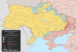
A map of southeastern Ukraine (with a Europe location inset) made by the Wikimedia community in September/October 2014 to depict the Russian annexation of Crimea and the War in Donbas.
Map of Ukraine on a coin. Minted as a part of the Oblasts of Ukraine (coins serie)(uk). Crimea name title text placed on top, and Ukraine title text placed below the map.
2021
The World Turned Upside Down (It's No Game)
Mark Wallinger
Map of Ukraine on the upside down terrestrial globe. (preview image cropped from a full globe photo)
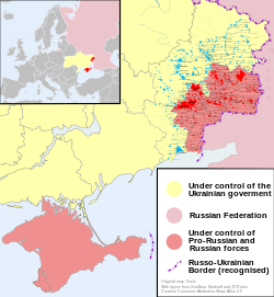
A map of southeastern Ukraine (with a Europe location inset) made by the Wikimedia community in September/October 2014 to depict the Russian annexation of Crimea and the War in Donbas.
The Black Sea Globe 3D model and rendered as a part of EU4EMBLAS project for the educational winter school «The Globe of The Black Sea», resulted in creation of artistic portolans for the «Black Sea Globe» exhibitions in Ukraine.
Live online map of the critical breaking news of Ukraine and world news releated to Ukraine, with geolocated source or place of news. Mostly focused on Russo-Ukrainian War. Also, there are regional version of the map for the Middle East, Africa, etc.
Live online map to disseminate air raid alerts and other sort of danger warnings in Ukraine. Shows live notifications and provides access to archived data. There are timelines and tools to analyze the data, visualize it on map and create statisticcharts.
↑The overall Tendenz of the caption is negative towards Ukrainian independence; at the time, the United States and other Allies of World War I were trying to assist the Whites to restore the Russian Empire (which had been "dismembered" into "fragments", suggesting it should be put back together), and engaged in direct combat with the Central Powers, which had just (depending on one's point of view) invaded/liberated Ukraine. On the other hand, the Allies did favour an independent Polish state, primarily as an ally against Germany and Austria-Hungary. Reflecting a pro-Polish perspective, the caption states that the transfer of Kholm to Ukraine was done "on the basis of the extreme claims of the Ukrainians", while pointing out "Ukraine gets no Austro-Hungarian territory"; UPR diplomats had indeed sought the inclusion of Eastern Galicia. Perhaps somewhat ironically, right next to this map, The New York Times reprinted "Ukraine's Struggle for Self-Government", an article written just before the war by Mykhailo Hrushevsky (president of the Ukrainian People's Republic, 28 March–29 April 1918), with a very positive attitude towards Ukrainian independence.
↑Ukraine has long been known as "the Breadbasket of Europe"; the map states In der Ukraine liegt das berühmte Schwarzerdegebiet. Dieses erzeugte fast das ganze Ausfuhrgetreide Rußlands. ("Ukraine is home to the famous black earth region. This produced almost all of Russia's export grain.") It was especially the unfolding food crisis and famine in Austria in late 1917 and early 1918 which pushed diplomats of Austria-Hungary to conclude a separate peace with the Ukrainian People's Republic, recognising its independence on the basis of national self-determination, knowing this would embolden ethnic separatism within their own multi-ethnic empire; because without access to Ukrainian foodstuffs to feed its starving military and civilians, a domestic revolution was expected to topple the Habsburg monarchy within weeks. (This is why the Treaty of 9 February 1918 was labelled a "Bread Peace". In the end, the foodstuffs from Ukraine only bought Austria-Hungary several more months of time, before the emboldened separatists indeed pushed for independence, and caused the Dissolution of Austria-Hungary in late 1918).[15] The map goes on to summarise how Ukraine's mineral industry might benefit the Central Powers: "The economic production of Ukraine in peacetime could secure the need of the Central Powers, its rich deposits of coal, iron ore, salt and petroleum would leave a surplus for Central Europe."
12Pinto, Karen. "The Maps are the Message: Mehmet II's Patronage of an 'Ottoman Cluster'". Imago Mundi 63.2 (2011): 155-179. DOI: 10.1080/03085694.2011.568703.
↑Pernal, Andrew B. "Two Newly-Discovered Seventeenth-Century Manuscript Maps of Ukraine". Od Kijowa do Rzymu. Białystok: Instytut Badań nad Dziedzictwem Kulturowym Europy, 2012, 188.
↑"Panel IV". The Cresques Project. Retrieved 2 August 2025. The city of Leopolis [Lviv]. Some merchants arrive at this city heading to the Levant via the Sea of La Mancha [North Sea/Baltic Sea] in Flanders.
This page is based on this Wikipedia article Text is available under the CC BY-SA 4.0 license; additional terms may apply. Images, videos and audio are available under their respective licenses.


