Cartography of Palestine

Last updated

The cartography of the region of Palestine, also known as cartography of the Holy Land and cartography of the Land of Israel, [1] is the creation, editing, processing and printing of maps of the region of Palestine from ancient times until the rise of modern surveying techniques. For several centuries during the Middle Ages it was the most prominent subject in all of cartography, [2] and it has been described as an "obsessive subject of map art". [3]

Contents

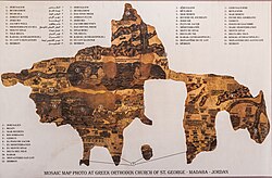
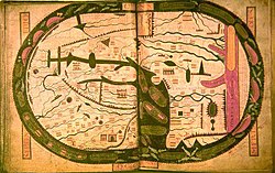
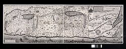
The history of the mapping of Palestine is dominated by two cartographic traditions: the biblical school and the classical school. [4] The earliest surviving maps of the biblical tradition derive from the attempts of the early Church Fathers to identify and illustrate the primary locations mentioned in the Bible, and to provide maps for Christian pilgrimage. [4] The earliest surviving maps of the classical tradition derive from the scientific and historical works of the Greco-Roman world; [4] the European rediscovery of Ptolemy's works in the 1400s ended the domination of the biblical tradition. [5] Many Graeco-Roman geographers described the Palestine region in their writings; however, there are no surviving pre-modern originals or copies of these maps – illustrations today of maps according to geographers such as Hecataeus, Herodotus or Eratosthenes are modern reconstructions. The earliest surviving classical maps of the region are Byzantine versions of Ptolemy's 4th Asia map. [6] [7] Cartographic history of Palestine thus begins with Ptolemy, whose work was based on that of the local geographer Marinus of Tyre. [5]

The first lists of maps of the region were made in the late 19th century, by Titus Tobler in his 1867 Geographical Bibliography of Palestine and subsequently by Reinhold Röhricht in his 1890 Geographical Library of Palestine. [8] [9] In a series of articles in the Journal of the German Association for the Study of Palestine between 1891 and 1895, Röhricht presented the first detailed analysis of maps of the region in the middle- and the late Middle Ages. [8] [10] They were followed in 1939-40 by Hans Fischer's History of the Cartography of Palestine. [11] This article lists maps that progressed the cartography of region before the rise of modern surveying techniques, showing how mapmaking and surveying improved and helped outsiders to better understand the geography of the area. Imaginary maps and copies of existing maps are excluded.

Notable maps of Palestine

Early maps (2nd–10th centuries)

DateTitle Cartographer CommentsRegion name givenImage
150Ptolemy's 4th Asia map Ptolemy and Marinus of Tyre Considered the "prototype delineation" of the region, Ptolemy's map was based on a lost work by Marinus, born in neighboring Tyre. The earliest known copy, pictured here, is the Codex Vaticanus Urbinas Graecus 82, thought to be from a manuscript of Ptolemy's Geography assembled by Maximus Planudes in Constantinople c. 1300. [4] The large red letters in the center say in Greek : Παλαιστινης or Palaistinis. Oldest surviving Ptolemaic map of Palestine, from Ptolemy's fourth map of Asia.png
385Jerome map Jerome and Eusebius The earliest known copy is from 1150, [12] the "Tournai map of Asia", shown here. The map comes from a manuscript of Jerome's De situ et nominibus locorum Hebraeorum, which Jerome states is a copy of Eusebius's Onomasticon. [12] Jerome also explains that Eusebius composed a map which showed the divisions of the Twelve Tribes; no copy of this division has survived. [12] no regional name shown Tournai map of Palestine and Syria, after Eusebius and Jerome 01.jpg
410 Notitia Dignitatum unknown Notitia Dignitatum of c. 410 AD showing Dux Palestinae, [13] a military region of the Byzantine Empire. [14] This 1436 manuscript by Peronet Lamy is the earliest known copy to survive complete; it was modelled after the lost "Codex Spirensis". [15] Dux Palastinae Notitia Dignitatum - Dux Palestinae.jpg
450 Tabula Peutingeriana unknownThought to be the only surviving map of the Roman cursus publicus , the state-run road network; the surviving map was created by a monk in Colmar in eastern France in 1265, is named after German antiquarian Konrad Peutinger, and is conserved at the Austrian National Library in Vienna. [16] Palestina Palestine in the TabulaPeutingeriana (cropped).jpg
c.560–565 Madaba Map unknownThe earliest map of Palestine surviving in its original form, [17] [18] and the oldest known geographic floor mosaic in art history. The mosaic was discovered in 1884, but no research was carried out until 1896. [19] [20] It has been heavily used for the localisation and verification of sites in Byzantine Palaestina Prima. It is the earliest surviving map showing the divisions of the Twelve Tribes. [21] Labels Greek : οροι Αιγυπτου και Παλαιστινης, oroi Aigyptou kai Palaistinis, the "border of Egypt and Palestine". Madaba Map reproduction.jpg
776 Beatus map Beatus of Liébana The first medieval Christian world map of relevance to the cartography of Palestine. [22] This copy from 1060 is thought to be the closest to the original out the 14 surviving manuscripts. [22] no regional name shown Beatus map.jpg
952Istakhri map Istakhri Drawn in 952 AD, copy from 1298. [23] no regional name shown Palestine in the 952 CE map of ash-Sham by Ibrahim ibn Muhammad Istakhri (cropped).jpg
995Cotton mapunknownKnown as the "Anglo-Saxon" world map. The earliest known map of the world (rather than just the region) showing the divisions of the Twelve Tribes. Thought to be based on the map of Orosius, which is no longer extant. [24] no regional name shown Cotton world map.jpg

Crusader maps (12th–14th centuries)

DateTitle Cartographer CommentsRegion name givenImage
1154 Tabula Rogeriana Muhammad al-Idrisi The Tabula Rogeriana was created in 1154AD; copy from 1533. [25] The middle of the right hand page label Arabic : فلسطين, romanized: Filasṭīn, lit. 'Palestine' Tabula Rogeriana Muhammad al-Idrisi map of Syria, Palestine, Sinai.png
1100sAshburnham Libri mapunknownEurope’s oldest surviving sheet map after the ninth-century Plan of Saint Gall. [26] no regional name shown Twelfth century map of Palestine, Biblioteca Medicea Laurenziana, Ashburnham Libri MS 1882.png
1100sTournai mapunknown12th century copy of a map of Asia may which accompanied a manuscript of De situ et nominibus locorum Hebraeorum, a 4th-5th century work of Jerome. [27] no regional name shown Tournai map of Asia.jpg
1250Oxford Outremer map Matthew Paris Created in c.1250, thought to be by Matthew Paris [28] The Kishon River has the following text along it: Latin : Iste torrens q[ui] parvus est, dividit Siriam a palestinam, i[d est] terram sactam q[ue] est versus austrum et palestinam que est versus aquilonem, lit. 'This river, which is small, divides Syria from Palestine, that is, the Holy Land, which is to the south, and Palestine, which is to the North.' Oxford Outremer Map of Matthew Paris.jpg
1300Earliest Burchard map Burchard of Mount Sion Considered to be the oldest known Burchard map. [29] [30] no regional name shown Burchard map of Palestine from the Archivio di Stato di Firenze.png
1300sLater Burchard map Burchard of Mount Sion A later map attributed to Burchard. [31] [30] no regional name shown Burchard map of Palestine from the Biblioteca Medicea Laurenziana.png
1321 Sanudo-Vesconte map Pietro Vesconte Described by Adolf Erik Nordenskiöld as "the first non-Ptolemaic map of a definite country". [32] Published in Liber Secretorum Fidelium Crucis , a work intended to rekindle the spirit of the crusades. Considered the "first 'modern map' of Palestine" and "served as the basis for most maps of 'Modern Palestine'" throughout the following centuries. [33] Terra Sancta The map of the Holy Land by Marino Sanudo (drawn in 1320).jpg

Notable 15th–18th century maps

DateTitle Cartographer CommentsRegion name givenImage
1459 Fra Mauro map Fra Mauro 1459 world map, considered the most accurate of its age. Fra Mauro had become familiar with the Near East in his travels as s soldier. [34] Shows the region of "Palestina" FraMauroMapMiddleEast.jpg
1475Berlinghieri map Francesco Berlinghieri Published in the Rudimentum Novitorium it was a version of Ptolemy's map, brought up to date. [35] Together with three updated maps of European countries, Adolf Erik Nordenskiöld described it as the "first germ of modern cartography" [32] Named "Palestina Moderna et Terra Sancta" (Modern Palestine and the Holy Land) Present-Day Palestine and the Holy Land - 1400s.png
1532Ziegler map Jacob Ziegler 1532 map by Jacob Ziegler [36] [37] The map is important to the development of the cartography of Palestine as it represents an early synthesis of multiple sources, including Burchard of Mount Sion, Sanuto, Ptolemy, Strabo, Pliny the Elder, the Antonine Itinerary, Jerome and Eusebius. [38] "Universalis Palaestinae, continens superiores partuculares tabulas" [39] 1532 map of Palestine by Jacob Ziegler.jpg
1537Mercator map Gerardus Mercator 1537 map by Gerardus Mercator, three decades before he published his famous Mercator projection. This map was Mercator's first published map, and was based on the map of Jacob Ziegler. [36] The caption "Candido lectori s[alus]. Palestinam hanc..." translates as: "Fair reader, greeting! We have drawn this map of Palestine, and the Hebrews' route into it from Egypt through the stony regions of Arabia" [40] 1537 Mercator map of Palestine (Candido lectori S. Palestinam hanc).jpg
1570Ortelius map Abraham Ortelius 1570 map in Theatrum Orbis Terrarum. [41] Ortelius's depiction of a biblical Palestine in his otherwise contemporary atlas has been criticized; Matari described it as an act "loaded with theological, eschatological, and, ultimately, para-colonial Restorationism". [42] Captioned "Palaestinae Sive Totius Terrae Promissionis Nova Descriptio" ("Palestine, the whole of the Promised Land, a new description") 1570 Palestinae Hondius.jpg
1590van Adrichem map Christian van Adrichem van Adrichem was a Dutch priest; his maps were published in his Theatrum Terrae Sanctae et Biblicarum Historiarum. [43] Terra Promissionis Christian van Adrichem 1590 map Situs Terrae Promissionis SS bibliorum intelligentiam exacte aperiens.jpg
1620Zaddik map Jacob ben Abraham Zaddiq A translation into Hebrew of van Adrichem's 1590 map, it is the oldest known printed map in Hebrew. [44] The first line of the framed colophon includes the description: Hebrew : ציור מצב ארצות כנען, lit. 'A Drawing of the Situation of the Lands of Canaan' JacobBenAvraham1621.jpg
1648–1657Celebi map Kâtip Çelebi This 1732 copy of the map by Ottoman geographer Kâtip Çelebi (1609–57) is from the first printed atlas in the Ottoman Empire, and represented the first detailed mapping of the Asian provinces of the empire. [45] Shows the term ارض فلسطين ("Land of Palestine") extending vertically down the length of the Jordan River. Houghton Typ 794.34.475 - Katip Celebi, Kitab-i cihannuma.jpg
1651De la Rue map Philippe de La Rue From the 1651 six-map atlas La Terre sainte en six cartes géographiques. It was the first published historical atlas in world cartography, in systematically chronological order. The other five maps covered land of Canaan and the Exodus, the Promised Land, Solomon's kingdom, the land of the Jews at the time of Christ, and the Christian Patriarchate of Jerusalem. [46] Sourie and Terre Saincte. Sourie Ou Terre Saincte Moderne, Philippe de La Rue.jpg
1655Heidmann map Christoph Heidmann Published almost three decades after his death, this map accompanied his Palestina siue Terra SanctaPalestina and Terre Sanctae Christophori Heidmanni Palaestina.jpg
1714Reland map Adriaan Reland 1714 mapPalaestinae Reland map of Palestine.jpg
1745Pococke map Richard Pococke 1745 mapHoly Land and Syria A Map of the Holy Land and Syria - Pococke Richard - 1745.jpg
1769Bachiene and Maas mapBachiene and Maas1769 mapPalaestina Bachiene and Mass Charte von Palaestina 1769.jpg
1794d'Anville map Jean Baptiste Bourguignon d'Anville Published 1794, almost thirty years after his 1767 map of Biblical Palestine. [47] [48] Palestina Anville, Jean Baptiste Bourguignon. Turkey in Asia. 1794.jpg

Notable 19th century maps

DateTitle Cartographer CommentsRegion name givenImage
1799 Carte de l'Égypte (Description de l'Égypte) Pierre Jacotin Originally prepared during the French campaign in Egypt and Syria; 47 sheets were prepared, with the Palestine area being covered by sheets 43-47. The first triangulation-based map of Palestine, it was used as the basis for many most maps of the region until the PEF Survey in the 1870s. [49] [50] It is considered flawed, primarily since it included a significant number of incorrect or imagined details, which had been “added to the map ad libitum where the French had not been able to survey.” [50] Palestine Jacotin's 1799 survey, extract showing Palestine.png
1803 Cedid Atlas Müderris Abdurrahman Efendii The first modern printed atlas in the Ottoman Empire, part of the Nizam-I Cedid reforms of Sultan Selim III, showing Ottoman Syria in the 1803. [45] Considered to be based on the d'Anville 1794 map (published in William Faden's General Atlas), it contained important adaptations to represent Ottoman geographic representations of the provinces. [45] Shows the term "ارض فلاستان" ("Land of Palestine") in large script on the bottom left. Cedid Atlas (Middle East) 1803.jpg
1815Arrowsmith map Aaron Arrowsmith The title "A Sketch of the Countries between Jerusalem and Aleppo" is likely a reference to Henry Maundrell's Journey from Aleppo to Jerusalem published in 1703; the map's description of Jacob's Well is a direct quote from Maundrell. The map also quotes Ulrich Jasper Seetzen, whose Brief Account of the Countries Adjoining the Lake of Tiberias, the Jordan and the Dead Sea was published in 1809. [51] The map is a combination of a modern map and a biblical map (showing the Twelve Tribes) [51] Pashalic of Acre Composite, A Sketch of the Countries between Jerusalem and Aleppo.jpg
1822Burckhardt map Johann Ludwig Burckhardt Map accompanying Burckhardt's Travels in Syria and the Holy Land, published in 1822, five years after his travels in the region.Syria and the Holy Land Burckhardt's map of Syria and Holy Land, showing Palestine and Egypt and the Ottoman Pashaliks.jpg
1830Hall map Sidney Hall 1830 map shows the Ottoman divisionsPalestine Sidney Hall 1830 map of Palestine showing Ottoman divisions.jpg
1840 Royal Engineers map Charles Rochfort Scott The first British army survey, carried out during the Oriental Crisis of 1840. It represented the second modern, triangulation-based, attempt at surveying Palestine. [50] It was not published at the time; although a private printing for the British Foreign Office was produced in 1846, and it was used in the creation of Van de Velde's map. [50] none 1840 map of Palestine, sheet 3 of 3 from Map of Syria, constructed from the surveys and sketches of the undermentioned officers in that country in 1840-1841, by Major R. Rochfort Scott, R. Staff-Corps.jpg
1841 Kiepert map Heinrich Kiepert Published in 1841 to accompany the first edition of Biblical Researches in Palestine by Edward Robinson, known as the "Father of Biblical Geography", and again in 1856 to accompany the second edition. [52] Palestine Heinrich Kiepert 1841 map of Palestine (combined).jpg
1843Hughes map William Hughes Shows the Ottoman administrative districts in detail, made for the Society for the Diffusion of Useful Knowledge. Hughes had been producing popular maps of Palestine for almost a decade, notably in his 1840 Illuminated Atlas of Scripture geography. [53] Palestine Palestine with the Hauran and the adjacent districts, William Hughes 1843.jpg
1849Lynch map William F. Lynch Prepared on behalf of the United States Hydrographic Office. Published in Narrative of the United States' Expedition to the River Jordan and the Dead Sea.The Dead Sea and River Jordan Map of the River Jordan and Dead Sea by W. F. Lynch.png
1850Zimmermann mapCarl ZimmermannThe Atlas von Palaestina und der Sinai Halbinsel, in 15 sectional sheets. Part of a wider Atlas of Asia, published as a supplement to Carl Ritter's ErdkundePalaestina Index Map and Sectional Title Page, Atlas of Palestine and the Sinai Peninsula (cropped).jpg
1858 Van de Velde map Charles William Meredith van de Velde Published in 1858. One of the most accurate maps published prior to the PEF Survey. [54] The Holy Land 1858 Map of the Holy Land by C.W.M. Van de Velde... from his own surveys in 1851 & 1852, from those made in 1841 by Majors Robe and Rochfort Scott, Lieut. Symonds... and from the Results of the Researches made by Lynch, Robinson, Wi.jpg
1870Leves en GalileeJean-Joseph Mieulet and Isidore DerrienA follow-up to a map of Lebanon. It was intended to be the first part of a complete coverage of Palestine, but the expedition was recalled to France at the outbreak of the Franco-Prussian war. It was published in 1873. [55] Galilee MieuletDerrienMap-Gallica.jpg
1872-1880 PEF Survey Charles Wilson and othersCarried out by the Palestine Exploration Fund, with support from the War Office. [56] Represented the peak of the cartographic work in Palestine in the nineteenth century. [57] 26 sheets of "Western Palestine" and 1 sheet of "Eastern Palestine". PEF Survey of Western Palestine composite.jpg

Modern cartography

Biblical / imaginary maps

See also

Related Research Articles

<span class="mw-page-title-main">Qalandia</span> Municipality type D in Jerusalem, State of Palestine

Qalandia, also Kalandiya, is a Palestinian village located in the West Bank, between Jerusalem and Ramallah, just west from the Jerusalem municipality boundary. The village had a population of 572 residents in 2017. Qalandia is also the name of a refugee camp, established by UNRWA in 1949. It is located just east from Jerusalem municipality. Qalandia refugee camp was built for Palestinians refugees from Lydda, Ramle and Jerusalem of the 1948 Palestinian expulsion and flight.

<span class="mw-page-title-main">Suba, Jerusalem</span> Place in Jerusalem, Mandatory Palestine

Suba was a Palestinian Arab village west of Jerusalem that was depopulated and destroyed in 1948. The site of the village lies on the summit of a conical hill called Tel Tzova, or Jabal Suba, rising 769 meters above sea level, and it was built on the ruins of a Crusader castle.

<span class="mw-page-title-main">Turmus Ayya</span> Palestinian village in Ramallah and al-Bireh, West Bank, State of Palestine

Turmus Ayya is a Palestinian town located in the Ramallah and al-Bireh Governorate in the West Bank, in Palestine. According to the Palestinian Central Bureau of Statistics (PCBS), it had a population of 2,464 in 2017. An estimated 80% of the residents are Palestinian binationals with US citizenship.

<span class="mw-page-title-main">Gustaf Dalman</span> German writer and explorer of Palestine

Gustaf Hermann Dalman was a German Lutheran theologian and orientalist. He did extensive field work in Palestine before the First World War, collecting inscriptions, poetry, and proverbs. He also collected physical articles illustrative of the life of the indigenous farmers and herders of the country, including rock and plant samples, house and farm tools, small archaeological finds, and ceramics. He pioneered the study of biblical and early post-biblical Aramaic, publishing an authoritative grammar (1894) and dictionary (1901), as well as other works. His collection of 15,000 historic photographs and 5,000 books, including rare 16th century prints, and maps formed the basis of the Gustaf Dalman Institute at the Ernst Moritz Arndt University, Greifswald, which commemorates and continues his work.

<span class="mw-page-title-main">Rantiya</span> Place in Jaffa, Mandatory Palestine

Rantiya was a Palestinian village, located 16 kilometers east of Jaffa. During the British Mandate in Palestine, in 1945 it had a population of 590 inhabitants.

<span class="mw-page-title-main">Beitunia</span> Municipality type B in Ramallah and al-Bireh, State of Palestine

Beitunia, also Bitunya, is a Palestinian city located 3 kilometers (1.9 mi) west of Ramallah and 14 kilometers (8.7 mi) north of Jerusalem, in the Ramallah and al-Bireh Governorate of Palestine, in the central West Bank. According to the Palestinian Central Bureau of Statistics, the city had a population of 26,604 in 2017, making it the third largest locality in its governorate after al-Bireh and Ramallah.

<span class="mw-page-title-main">Abwein</span> Village in the West Bank, State of Palestine

Abwein is a Palestinian village in the Ramallah and al-Bireh Governorate of the State of Palestine, located about 37 kilometers north of Ramallah, in the northern West Bank. According to the Palestinian Central Bureau of Statistics, Abwein's population was 3,496 in 2017.

Ajjul is a Palestinian village in the Ramallah and al-Bireh Governorate in the northern West Bank, located north of Ramallah. There are two archaeological sites or khirbets to the east of the village. One of the khirbets is dedicated to a former resident of Ajjul, Sheikh Abdul. Ajjul is governed by a village council of three members.

<span class="mw-page-title-main">Saffa, Ramallah</span> Town in the West Bank, State of Palestine

Saffa is a Palestinian town in the Ramallah and al-Bireh Governorate, located west of Ramallah in the northern West Bank. According to the Palestinian Central Bureau of Statistics (PCBS), the town had a population of 4,374 inhabitants in 2017.

<span class="mw-page-title-main">Al-Mazra'a ash-Sharqiya</span> Municipality type C in Ramallah and al-Bireh, State of Palestine

al-Mazra'a ash-Sharqiya is a Palestinian town in the Ramallah and al-Bireh Governorate, located northeast of Ramallah in the northern West Bank. According to the Palestinian Central Bureau of Statistics (PCBS), the town had a population of 4,063 inhabitants in 2017.

<span class="mw-page-title-main">Ein Qiniya</span> Local Development Committee in Ramallah and al-Bireh, State of Palestine

Ein Qiniya or 'Ayn Kiniya is a Palestinian village in the northern West Bank, located 7 kilometers (4.3 mi) northwest of Ramallah and is a part of the Ramallah and al-Bireh Governorate. Ein Qiniya has existed since the Roman-era of rule in Palestine. The village is very small with no public structures or institutions and is governed by a local development committee. Ein Qiniya is regionally notable for being a spring and autumn time picnic resort.

<span class="mw-page-title-main">Ein Siniya</span> Local Development Committee in Ramallah and al-Bireh, State of Palestine

Ein Siniya is a small Palestinian village in the Ramallah and al-Bireh Governorate, 10 kilometers (6.2 mi) north of Ramallah, and approximately 1km northeast from Jifna. It lies in a valley surrounded with olive and fig-terraces.

<span class="mw-page-title-main">Bir Ma'in</span> Place in Ramle, Mandatory Palestine

Bir Ma'in was a Palestinian Arab village in the Ramle Subdistrict. It was depopulated during the 1948 Arab-Israeli War on July 15, 1948 during the second phase of Operation Danny by the First and Second Battalions of the Yiftach Brigade. It was located 14 km east of Ramla. The village was defended by the Jordanian Army.

Jibiya is a Palestinian village in the Ramallah and al-Bireh Governorate.

<span class="mw-page-title-main">Cartography of Jerusalem</span> Map printing of Jerusalem spanning from ancient times

The cartography of Jerusalem is the creation, editing, processing and printing of maps of Jerusalem from ancient times until the rise of modern surveying techniques. Most extant maps known to scholars from the pre-modern era were prepared by Christian mapmakers for a Christian European audience.

<span class="mw-page-title-main">Ordnance Survey of Jerusalem</span> 1864–65 mapping of Jerusalem

The Ordnance Survey of Jerusalem of 1864–65 was the first scientific mapping of Jerusalem, and the first Ordnance Survey to take place outside the United Kingdom. It was undertaken by Charles William Wilson, a 28-year-old officer in the Royal Engineers corps of the British Army, under the authority of Sir Henry James, as Superintendent of the Ordnance Survey, and with the sanction of George Robinson, 1st Marquess of Ripon as Secretary of State for War. The team of six Royal Engineers began their work on 3 October 1864. The work was completed on 16 June 1865, and the report was published on 29 March 1866.

<span class="mw-page-title-main">1858 Van de Velde maps of Palestine and Jerusalem</span>

The Van de Velde maps of Palestine and Jerusalem were an important scientific mapping of the region of Palestine and mapping of Jerusalem, published in 1858 by Dutch cartographer Charles William Meredith van de Velde.

<span class="mw-page-title-main">1840–41 Royal Engineers maps of Palestine, Lebanon and Syria</span>

The 1840–41 Royal Engineers maps of Palestine, Lebanon and Syria was an early scientific mapping of Palestine, Lebanon and Syria.

<i>Carte de lÉgypte</i> (Description de lÉgypte) 19th century map

The Carte de l'Égypte, from the Description de l'Égypte, was the first triangulation-based map of Egypt, Syria and Palestine. The mapmaking expedition was led by Pierre Jacotin. It was used as the basis for many most maps of the region for much of the nineteenth century.

<span class="mw-page-title-main">Kiepert maps of Palestine and Jerusalem</span>

The Kiepert maps of Palestine and Jerusalem were important scientific mappings of the region of Palestine and mappings of Jerusalem, initially published in 1841 by German cartographer Heinrich Kiepert as the maps accompanying Biblical Researches in Palestine, the magnum opus of the "Father of Biblical Geography", Edward Robinson.

References

  1. Rubin 2018, p. 287-288: "Holy Land cartography reached its zenith with the publication of Heinrich Kiepert's maps and the highly accurate survey of the Palestine Exploration Fund (PEF)."
  2. Laor 1986, p. XI quote: "Cartography in the Middle Ages was generally of poor quality, with the exception of the cartography of the Holy Land, which reached a peak both in quality and quantity. For several centuries, the Holy Land was the most important and prominent subject of mapmaking.
  3. Wood 2010, p. 232: "In fact, the mapping of Palestine is a paradigm of the history of mapmaking; but since it’s also the object of counter-mapping and counter-counter-mapping, and an obsessive subject of map art, it makes a uniquely trenchant example around which to review the arguments of this book."
  4. 1 2 3 4 Nebenzahl 1986, p. 8.
  5. 1 2 Nebenzahl 1986 , p. 8: "Cartography as we know it today begins with this spectacular map of the world at the time of Claudius Ptolemy. It sets the stage for the history of mapping the Holy Land... his work was to become the model for scientific cartography during the great revivals of mapmaking: the tenth-century Golden Age of Islam and the European Renaissance. The rediscovery of Ptolemy in the fifteenth century was particularly important for maps of the Holy Land; it ended the almost complete domination of mapmaking by Church dogma throughout the Middle Ages... Around AD 150 he produced his Geographia, the earliest known atlas of the world.".
  6. Wilson, Nigel Guy (2006). "Cartography". Encyclopedia of Ancient Greece. Psychology Press. p. 145. ISBN   978-0-415-97334-2. As geographical knowledge improved, various writers recorded what they believed to be the spatial relationships of territories and peoples to each other, and it is from this information that many modern historical atlases present items such as the world according to Hecataeus or Herodotus or Eratosthenes: actual ancient versions of these maps do not survive (indeed, modern versions seem to originate in the 1883 volumes of Bunbury), although there do exist Byzantine versions of Ptolemy's maps.
  7. Leo Bagrow, “The Origin of Ptolemy's Geographia.” Geografiska Annaler, vol. 27, 1945, pp. 318–387. JSTOR, www.jstor.org/stable/520071; p.331, “Hecataeus of Milet… Herodotus… Dicaearchus of Messina… Crates of Mallos… Hipparchus… Posidonius of Apamea… Marinus of Thyre… All these maps before Ptolemy have, naturally, not come down to us.”
  8. 1 2 Goren 2001, p. 98.
  9. Tobler 1867 , pp. 232–246: "Karten" and Röhricht 1890 , pp. 598–662
  10. Röhricht 1891 , pp. 8–11, 87–92, 137–141; Röhricht 1892 , pp. 34–39 and 185–188; and Röhricht 1895 , pp. 173–182
  11. Fischer 1939 and Fischer 1940
  12. 1 2 3 Nebenzahl 1986, p. 18.
  13. Röhricht 1890, p. 7.
  14. Masalha 2019, p. 98.
  15. Preciado 1989, p. 66.
  16. Laor 1986, p. XI.
  17. Nebenzahl 1986, p. 2: "The Madaba mosaic, the earliest surviving original map of the area and the first to show the Twelve Tribes of Israel"
  18. North 1979, p. 85: "Certainly it is the oldest map of Palestine now existing in the form in which it was first produced"
  19. Piccirillo, Michele (September 21, 1995). "A Centenary to be celebrated". Jordan Times. Franciscan Archaeology Institute. Retrieved 18 January 2019. It was only Abuna Kleofas Kikilides who realised the true significance, for the history of the region, that the map had while visiting Madaba in December 1896. A Franciscan friar of ltalian-Croatian origin born in Constantinople, Fr. Girolamo Golubovich, helped Abuna Kleofas to print a booklet in Greek about the map at the Franciscan printing press of Jerusalem. Immediately afterwards, the Revue Biblique published a long and detailed historic-geographic study of the map by the Dominican fathers M.J. Lagrange and H. Vincent after visiting the site themselves. At the same time. Father J. Germer-Durand of the Assumptionist Fathers published a photographic album with his own pictures of the map. In Paris, C. Clermont-Gannau, a well known oriental scholar, announced the discovery at the Académie des Sciences et belles Lettres.
  20. Levy-Rubin & Rubin 1996, p. 352–353.
  21. Nebenzahl 1986, p. 18a"The Madaba Mosaic is the earliest surviving map to show the tribal divisions, and its text is almost identical with the surviving Greek manuscript of Eusebius's Onomastikon"
  22. 1 2 Nebenzahl 1986, p. 26-27.
  23. Tishby 2001, p. 128.
  24. Nebenzahl 1986, p. 30-31.
  25. Tishby 2001, p. 132.
  26. Harvey 2012, p. 31-39.
  27. Harvey 2012, p. 40-59.
  28. Harvey 2012, p. 60-73.
  29. Harvey 2012, p. 94-106.
  30. 1 2 Baumgärtner, Ingrid. "Burchard of Mount Sion and the Holy Land," Peregrinations: Journal of Medieval Art and Architecture 4, 1 (2013): 5-41. : "Burchard’s description, although little studied even today, is considered a key document that influenced the perception of Palestine in both text and image, in travel accounts and maps until far into the sixteenth century."
  31. Harvey 2012, p. 128-140.
  32. 1 2 Nordenskiöld 1889, p. 51, 64.
  33. Laor 1986, p. XII.
  34. Masalha 2019, p. 189,191.
  35. Laor 1986, p. 86-87.
  36. 1 2 Bartlett 2009, p. 191.
  37. Nissen 1956, p. 45.
  38. Bartlett 2009, p. 192-197.
  39. Rubin 2018, p. 173, footnote 7.
  40. Bartlett 2017, p. 52.
  41. Tishby 2001, p. 94.
  42. Matar 2011, p. 76.
  43. Tishby 2001, p. 96.
  44. Wajntraub & Wajntraub 1992, p. 45.
  45. 1 2 3 Tamari 2017, pp. 27–29.
  46. Goffart, W. (2011). Historical Atlases: The First Three Hundred Years, 1570-1870. University of Chicago Press. p. 108-110. ISBN   978-0-226-30072-6. La Ruë was a Holy Land specialist associated with the mapmaking enterprise of Nicolas Sanson, patriarch of French cartography. Hardly anything is known of La Ruë. His small atlas, La Terre sainte en six cartes géographiques (Paris, 1651), is the first collection of maps laid out "from the origins to the present," in a systematically chronological order. This sequence, now commonplace, was so far from customary in La Ruë's time that no one imitated it for about fifty years.
  47. Laor 1986, p. 6,7.
  48. Goren 2002, p. 87-88.
  49. Karmon 1960, p. 155.
  50. 1 2 3 4 Schelhaas, Faehndrich & Goren 2017, p. 66.
  51. 1 2 Composite: A Sketch of the Countries between Jerusalem and Aleppo, David Rumsey Collection, see "Note"
  52. Schelhaas, Faehndrich & Goren 2017, p. 52.
  53. Schelhaas, Faehndrich & Goren 2017, p. 124.
  54. Moscrop 2000, p. 22.
  55. Dov Gavish (1994) French Cartography of the Holy Land in the Nineteenth Century, Palestine Exploration Quarterly, 126:1, 24-31, DOI: 10.1179/peq.1994.126.1.24
  56. Moscrop 2000, p. 135.
  57. Masalha 2019, p. 256a: "The systematic mapping, surveying and place‐naming projects ... reached their peak with the British Ordnance Survey of Western Palestine between 1871 and 1877."

Bibliography