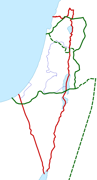
Defining borders of present day Israel
Prior to the declaration of Israel in 1948, the UN proposed a United Nations Partition Plan for Palestine based on the location of land legally purchased [2] and used to create Jewish Settlements in the area.


The cartography of Israel is the history of mapping and map creation of modern Israel as well as the historic Kingdom of Israel (Samaria) and Land of Israel. [1]
Prior to the declaration of Israel in 1948, the UN proposed a United Nations Partition Plan for Palestine based on the location of land legally purchased [2] and used to create Jewish Settlements in the area.
In October 2023, internet users noticed "the name Israel no longer appears on leading local digital maps services such as Baidu or Alibaba". [3] Sources report that major cities are still defined as well as the borders that define present-day Israel and Palestinian territories, but not the name itself. [4] WION (World Is One News) reported that it is because 'Chinese internet is getting inundated with antisemitism following the Israel-Hamas war'. [5]

Samaria, the Hellenized form of the Hebrew name Shomron, is used as a historical and biblical name for the central region of the Land of Israel. It is bordered by Judea to the south and Galilee to the north. The region is known to the Palestinians in Arabic under two names, Samirah, and Mount Nablus.
The Judea and Samaria Area is an administrative division used by the State of Israel to refer to the entire West Bank, which has been occupied by Israel since 1967, but excludes East Jerusalem. Its area is split into 165 Palestinian "islands" that are under total or partial civil administration by the Palestinian National Authority (PNA), and a contiguous area containing 230 Israeli settlements into which Israeli law is "pipelined".
Umm Khalid, also called Mukhalid, was a Palestinian village in the Tulkarm Subdistrict, 15 kilometers (9.3 mi) west of Tulkarm. It was an ancient site in the central coastline of what is now the city of Netanya, Israel.
Greater Israel is an expression with several different biblical and political meanings over time. It is often used, in an irredentist fashion, to refer to the historic or desired borders of Israel.

The Peel Commission, formally known as the Palestine Royal Commission, was a British Royal Commission of Inquiry, headed by Lord Peel, appointed in 1936 to investigate the causes of conflict in Mandatory Palestine, which was administered by the United Kingdom, following a six-month-long Arab general strike.
The region of Palestine, also known as historic Palestine, is a geographical area in West Asia. It includes modern-day Israel and the State of Palestine, as well as parts of northwestern Jordan in some definitions. Other names for the region include Canaan, the Promised Land, the Land of Israel, or the Holy Land.

The Palestine Exploration Fund is a British society based in London. It was founded in 1865, shortly after the completion of the Ordnance Survey of Jerusalem by Royal Engineers of the War Department. The Fund is the oldest known organization in the world created specifically for the study of the Levant region, also known as Palestine. Often simply known as the PEF, its initial objective was to carry out surveys of the topography and ethnography of Ottoman Palestine – producing the PEF Survey of Palestine. Its remit was considered to fall between an expeditionary survey and military intelligence gathering. There was also strong religious interest from Christians; William Thomson, Archbishop of York, was the first president of the PEF.

A historical atlas is a collection of maps and possibly illustrations that depict the historical geography of a particular region at a defined time period. These atlases typically include maps that show the political and cultural boundaries of different states as well as other data, and in some cases illustrations that provide information about important historical events and figures. They may also include timelines, charts, and other information to help readers understand the historical context of the maps. Historical atlases are used by scholars, students, and general readers to study and learn about the past.
The International Cartographic Association (ICA) is an organization formed of national member organizations, to provide a forum for issues and techniques in cartography and geographic information science (GIScience). ICA was founded on June 9, 1959, in Bern, Switzerland. The first General Assembly was held in Paris in 1961. The mission of the International Cartographic Association is to promote the disciplines and professions of cartography and GIScience in an international context. To achieve these aims, the ICA works with national and international governmental and commercial bodies, and with other international scientific societies.

Sebastia is a Palestinian village of about 3,205 inhabitants, located in the Nablus Governorate of the State of Palestine, some 12 kilometers northwest of the city of Nablus.
Surif is a Palestinian City in the Hebron Governorate located 25 km northwest of the city of Hebron. According to the Palestinian Central Bureau of Statistics census, Surif had a population of 17,287 in 2017. The population is entirely Muslim.

Jit is a Palestinian town in the northern West Bank, located 10 kilometers (6.2 mi) west of Nablus. According to the Palestinian Central Bureau of Statistics, the village had a population of 2,405 inhabitants in 2017.

An-Naqura is a Palestinian village in the Nablus Governorate in northern West Bank, located 10 kilometers northwest of Nablus and adjacent to the Israeli settlement of Shavei Shomron. According to the Palestinian Central Bureau of Statistics (PCBS) census, the village had a population of 1,545 in 2007 and 1,786 in 2017. An-Naqura is administered by a ten-member village council headed by Muhammad Hashish.

Kharas is a Palestinian town in the southern State of Palestine, located twelve kilometers northwest of Hebron, part of the Hebron Governorate. According to the Palestinian Central Bureau of Statistics, the town had a population of 9,139 inhabitants in 2017. It is situated at the northern mouth of the Wadi ’Arab near the ruins of 'Elah. Nearby towns include Nuba and Beit Ula to the south, Surif to the north and Halhul to the east. It has a total land area of 6,781 dunams.

Judea or Judaea is a mountainous region of the Levant. Traditionally dominated by the city of Jerusalem, it is now part of Palestine and Israel. The name's usage is historic, having been used in antiquity and still into the present day; it originates from Yehudah, a Hebrew name. Yehudah was a son of Jacob, who was later given the name "Israel" and whose sons collectively headed the Twelve Tribes of Israel. Yehudah's progeny among the Israelites formed the Tribe of Judah, with whom the Kingdom of Judah is associated. Related nomenclature continued to be used under the rule of the Babylonians, the Persians, the Greeks, and the Romans. Under the Hasmoneans, the Herodians, and the Romans, the term was applied to an area larger than Judea of earlier periods. In 132 CE, the Roman province of Judaea was merged with Galilee to form the enlarged province of Syria Palaestina.

Nitaf was a small, short-lived Palestinian Arab village in the Jerusalem Subdistrict. It was established in the early 20th century. It was forcefully depopulated during the 1947–1948 Civil War in Mandatory Palestine on April 15, 1948, during the second stage of Operation Dani. It was located 17 km west of Jerusalem, just north of Bayt Thul.
Survey of Israel - SOI is the survey and mapping department of the Israeli Ministry of Housing and Construction. It is the successor of the Survey Department of Palestine, which existed in Mandatory Palestine between 1920 and 1948.

The Land of Israel is the traditional Jewish name for an area of the Southern Levant. Related biblical, religious and historical English terms include the Land of Canaan, the Promised Land, the Holy Land, and Palestine. The definitions of the limits of this territory vary between passages in the Hebrew Bible, with specific mentions in Genesis 15, Exodus 23, Numbers 34 and Ezekiel 47. Nine times elsewhere in the Bible, the settled land is referred as "from Dan to Beersheba", and three times it is referred as "from the entrance of Hamath unto the brook of Egypt".
The cartography of the region of Palestine, also known as cartography of the Holy Land and cartography of the Land of Israel, is the creation, editing, processing and printing of maps of the region of Palestine from ancient times until the rise of modern surveying techniques. For several centuries during the Middle Ages it was the most prominent subject in all of cartography, and it has been described as an "obsessive subject of map art".
The Survey of Palestine was the government department responsible for the survey and mapping of Palestine during the British mandate period.