Cartography of Jamaica

Last updated

The Cartography of Jamaica is the history of surveying and creation of maps of Jamaica. A list of maps of Jamaica in chronological order is shown below.

Contents

1494–1949

Sortable table
K# [1] DateTitle Carto-
grapher
DescriptionImage
11528Map of Jamaica Benedetto Bordone A very simple map of Jamaica from Bordone's Isolario (The Book of Islands), printed in Venice in 1528. Jamaica 1528.png
21562Isola Cuba Nova Girolamo Ruscelli Fragment showing Jamaica from an early map of Cuba in Ruscelli's Atlas, probably the 1562 edition, published in Italy. [2] Jamaica 1562 (Girolamo Ruscelli).png
41572Jamaica Tomaso Porcacchi Early map of Jamaica (and part of Cuba) engraved by Girolamo Porro for Porcacchi's book L'Isole piu Famose del Mondo, first published in Venice in 1572. [3] Jamaica 1572 (Tomaso Porcacchi).jpg
81631Map of the Caribbean Gerardus Mercator(?)Fragment showing Jamaica from map of Cuba, Puerto Rico, Jamaica, Hispaniola and S Margarita Island (off the coast of Venezuela) in the first Cloppenburgh edition of the large-format Mercator-Hondius Atlas Minor, published in Amsterdam, 1630. [4] Jamaica 1631 (Mercator-Hondius).png
131671Novissima et Accura-tissima Jamaicae Descriptio John Ogilby Engraved by F Lamb, includes a table showing plantations, precincts and settlements on the island. [5]
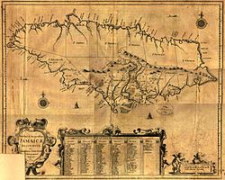
 Jamaica1671ogilby.jpg
171671A new and exact map of the isle of Jamaica Richard Bloome Survey carried out on the instructions of the Governor Thomas Modyford divided into precincts and parishes Map Jamaica 1671.jpg
221676Jamaica and Barbados John Speed Top half of a hand tinted map of Jamaica and Barbados printed by Thomas Basset and Richard Chiswell, London, England. On the reverse there is a description of the two islands. [6] Jamaica 1676 (John Speed).jpg
261680Jamaica Nicolaes Visscher II Jamaica 1680 (Nicolaum Visscher).jpg
1683de Cuba et de Iamaica Alain Manesson Mallet An extract showing Jamaica from an engraving in Mallet's Description de L'Univers published by Thierry, Paris, 1683. [7] Jamaica 1683 (Allain Mallet).svg
1684A New and Exact Mapp of the Island of Jamaica Charles Bochart and Humphrey Knollis [8] A new & exact mapp of the island of Jamaica - with ye true and iust scituation of ye severall townes & churches ... LOC 99463761.tif
241688Insula Jamaica Robert Morden
491710Neiuwe Kaart van het Eyland Jamaica Hermann Moll
1711Jamaica
1715A New Map of the English Empire in the Ocean of America
or West Indies
John Senex
1717A New Map of the Island of Jamaica Herman Moll
541720The island of Jamaica divided into its principal parishes... Herman Moll The island of Jamaica, divided into its principal parishes, with the roads &c. (4578781549).jpg
1728The Island of Jamaica Herman Moll
1730Dominia Anglorum præcipuis in Insulis Americæ Homann's Heirs
651744A New and Accurate Map of the Island of Jamaica Emanuel Bowen A new & accurate map of the island of Jamaica. Divided into its principal parishes. LOC 74693274.jpg
641746La Jamaique Georges-Louis Le Rouge
661753Carte de l'Isle de Jamaique Jacques-Nicolas Bellin
711755A new map of Jamaica ... from actual surveys made ... from the year 1730 to 1749 [8] Patrick Browne
1757A Correct Map of Jamaica Georg Dionysius Ehret
771758Carte de l'Isle de Jamaique Jacques-Nicolas Bellin
761758Carte Particularie De L’ Isle De La Jamaique Jacques-Nicolas Bellin
1760A Correct Map of Jamaica
831762A Correct Map of the Island of Jamaica John Gibson
891765A New Map of the Island of Jamaica Thomas Kitchin
1011775Jamaica Thomas Jeffreys
1041779La Giammaica Antonio Zatta
1051780Carte de l'Isle de la Jamaique Rigobert Bonne
1311794A Map of the Island of Jamaica Bryan Edwards
1411805Charte von Jamaica Jean Baptiste Marie George Bory
de Saint Vincent
1812Isle de la Jamaique Arrowsmith
1451814Jamaica John Thomson
1501822
Geographical, Statistical, and Historical Map of Jamaica
Carrey & Lea
1511823Jamaica Fielding Lucas
1521825Jamaique J A Buchon
1835The British Island in the West Indies Society for the Diffusion of Useful Knowledge
1836Jamaica J & C Walker
1850Tourist Map of the Island of Jamaica Edward Vincent D'Invilliers
1851Jamaica J Rapkin / J Tallis
1854Jamaica Harvey Newcomb
1859Map of Haiti and Jamaica Edward Weller
1860Island of Jamaica Fullarton
1880General Chart of the Island of JamaicaJohn Purdy
1882Outline Map of JamaicaDangerfield
1892Cuba and Jamaica D Appleton & Co
1903Jamaica Dodd, Mead and Company
1908Jamaica Earthquake Vaughn Cornish
1910Jamaica Cram

1950–1979

The 1:50,000 series

Between the early 1950s and the late 1970s the UK Directorate of Overseas Surveys published several editions of a series of maps of Jamaica at the scale of 1:50,000. The following table summarises the known publication dates. Online copies can be found on Commons or at the University of Texas Libraries.

SheetFirst EditionSecond EditionThird EditionCommonsUniversity of Texas
Sheet A1959 First edition First edition
Sheet B1958 First edition First edition
Sheet C1959 (reprinted 1973) First edition First edition
Sheet D1959 (reprinted 1974) First edition First edition
Sheet E1958 (reprinted 1974) First edition First edition
Sheet F1958 (reprinted 1974) First edition First edition
Sheet G19581973 First edition
Sheet H19581973 (reprinted 1974) First edition
Sheet K1970 (reprinted 1974) Third edition
Sheet L19541966 (reprinted 1970 & 1973) Third edition
Sheet M19541967 (reprinted 1973) Third edition
Sheet N19541967 (reprinted 1971) Third edition
Index to the 1:50,000 maps of Jamaica published by the UK Directorate of Overseas Surveys from the early 1950s on. Index to Jamaica 50K maps.png
Index to the 1:50,000 maps of Jamaica published by the UK Directorate of Overseas Surveys from the early 1950s on.

Others

Sortable table
K# [1] DateTitle Cartographer Description
1967Jamaica Road Map Esso
1972Jamaica Road Map Texaco

1979–present

Town plans

Kingston

The 1:10,000 series

Between the early 1950s and the early 1970s the UK Directorate of Overseas Surveys published several editions of a series of maps of Kingston at the scale of 1:50,000. The following table summarises the known publication dates. Online copies can be found at the University of Texas Libraries.

SheetFirst EditionSecond EditionThird EditionUniversity of Texas
Central sheet1962 First edition
Sheet 119651972 First edition
Sheet 219651972 First edition
Sheet 319631972 First edition
Sheet 419641972 First edition
Sheet 519641972 First edition
Sheet 619641972 First edition

Others

Sortable table
DateTitle Carto-
grapher
Description
1702A Plan of Kingston Christian Lilly Map which may have been the combined work of John Goffe and Christian Lilly to provide a plan for the newly founded city. [9] [10]
1740-45Plan of KingstonMichael HayMap dedicated to Jamaica's governor Edward Trelawny. Several possible dates are given for its publication. [11] [12]
1764Plan de la Ville de KingstonJacques Nicolas BellinFrom the author's Le Petit Atlas Maritime, published in Paris, France in 1764. [13]
1891-06Kingston and environs War Office A lithograph published by Edward Stanford for the Intelligence Division of the War Office. It was based on earlier maps and Admiralty charts, updated with the observations of five army officers. The illustration shows an extract depicting Kingston Harbour. [14] Kingston Harbour (cropped).png
1897The City of KingstonJames H. StarkFrom the author's Stark's Jamaica Guide. [15]

Montego Bay

Petrol company road maps

Spanish Town

Petrol company road maps

Mandeville

Petrol company road maps

Bibliography

Related Research Articles

Sabina Park is a cricket ground and the home of the Kingston Cricket Club, and is the only Test cricket ground in Kingston, Jamaica.

<span class="mw-page-title-main">Los Angeles Metro Bus</span> Bus system in Los Angeles County, California

Los Angeles Metro Bus is the transit bus service in Los Angeles County, California operated by the Los Angeles County Metropolitan Transportation Authority (Metro). In 2023, the system had a ridership of 222,919,700, or about 723,100 per weekday as of the fourth quarter of 2023.

<span class="mw-page-title-main">Tamarindo, Costa Rica</span> District in Santa Cruz canton, Guanacaste province, Costa Rica

Tamarindo is a district of the Santa Cruz canton, in the Guanacaste province of Costa Rica, located on the Nicoya Peninsula.

The Arlington Central School District is one of thirteen public school districts serving residents of Dutchess County, New York.

<span class="mw-page-title-main">Chinese passport</span> Passport issued to Chinese mainland nationals

The People's Republic of China passport is a passport issued to citizens of the People's Republic of China for the purpose of international travel, and entitles its bearer to the protection of China's consular officials overseas.

This table contains international rankings of Finland, including previous years when available.

Pashtun Zarghun District, formerly known as Posht-e Zirghān or Posht-e Zirghūn, is situated in the central part of Herat Province, Afghanistan in the valley of the Hari River. The district center is Pashtun Zarghun.

<span class="mw-page-title-main">Michelin Pilot Challenge</span> Car racing competition held in Canada and the USA

The Michelin Pilot Challenge is a grand touring and touring car racing series run by the International Motor Sports Association. Originating from the Canadian Motorola Cup, the series was taken over by Grand-Am in 2001 to become the Grand-Am Cup following the demise of rival IMSA's Firehawk series of similar rules in the US. KONI became series sponsor for the start of the 2007 season when the series became known as the KONI Challenge Series, before renaming once more prior to the start of the 2009 season as the KONI Sports Car Challenge. The series name was once again changed for the 2010 season to Continental Tire Sports Car Challenge. In 2019, the series rebranded again after Michelin was selected to become the new official tire supplier of the series.

The roads in Jamaica allow people and goods to traverse the island of Jamaica, which is the third largest in the Caribbean. As of 2011, Jamaica has road network 22,121 kilometres in length.

<span class="mw-page-title-main">Center for Business and Economic Research</span>

The Center for Business and Economic Research (CBER), formerly the Bureau of Business Research, is an economic policy and forecasting research center housed within the Miller College of Business at Ball State University in Muncie, Indiana, USA. CBER research encompasses health care, public finance, regional economics, transportation, and energy sector studies. In addition to research, CBER serves as the forecasting element in the Muncie area – hosting five state and federal economic forecasting roundtables.

Visitors to Israel must obtain a visa from one of the Israeli diplomatic missions unless they come from one of the visa exempt countries.
All visitors must hold a passport that is valid for 6 months after the date of departure from Israel.

<span class="mw-page-title-main">Jamaica Urban Transit Company</span>

The Jamaica Urban Transit Company (JUTC) is the government-owned public transport service operating within the Kingston Metropolitan Transport Region (KMTR), Spanish Town and Portmore.

<span class="mw-page-title-main">Sonari Assembly constituency</span> Constituency of the Assam legislative assembly in India

Sonari Assembly constituency is one of the 126 assembly constituencies of Assam Legislative Assembly. Sonari forms part of the Jorhat Lok Sabha constituency.

References

  1. 1 2 Kapp, Captain Kit S (1968). "The Printed Maps of Jamaica up to 1825". Map Collectors' Circle . 5 (42). Retrieved 2013-10-30.
  2. "Archived copy". Archived from the original on 2009-10-01. Retrieved 2009-09-26.{{cite web}}: CS1 maint: archived copy as title (link)
  3. "Archived copy". Archived from the original on 2009-10-01. Retrieved 2009-09-22.{{cite web}}: CS1 maint: archived copy as title (link)
  4. "Archived copy". Archived from the original on 2009-10-01. Retrieved 2009-09-26.{{cite web}}: CS1 maint: archived copy as title (link)
  5. "Archived copy". Archived from the original on 2012-02-22. Retrieved 2015-05-21.{{cite web}}: CS1 maint: archived copy as title (link)
  6. "Archived copy". Archived from the original on 2009-10-01. Retrieved 2009-10-24.{{cite web}}: CS1 maint: archived copy as title (link)
  7. "Archived copy". Archived from the original on 2009-10-01. Retrieved 2009-10-24.{{cite web}}: CS1 maint: archived copy as title (link)
  8. 1 2 Higman & Hudson 2009 , p. 279
  9. "jamaica: kingston - Patricia E. Green Architects". sites.google.com. Retrieved 2021-03-14.
  10. Mann, Emily (2016-03-24). "Story of cities #9: Kingston, Jamaica – a city born of 'wickedness' and disaster". the Guardian. Retrieved 2021-03-14.
  11. Mann, Emily (2016-03-24). "Story of cities #9: Kingston, Jamaica – a city born of 'wickedness' and disaster". The Guardian. ISSN   0261-3077 . Retrieved 2021-03-14.
  12. "[Plan of Kingston]". Library of Congress. Retrieved 2021-03-14.
  13. "Plan de la ville de Kingston;". Library of Congress. Retrieved 2021-03-14.
  14. "Jonathan Potter" . Retrieved 18 October 2014.
  15. "1897". Kingston, Jamaica. 2012-08-18. Retrieved 2021-03-14.