
The geography of Israel is very diverse, with desert conditions in the south, and snow-capped mountains in the north. Israel is located at the eastern end of the Mediterranean Sea in West Asia. It is bounded to the north by Lebanon, the northeast by Syria, the east by Jordan and the West Bank, and to the southwest by Egypt. To the west of Israel is the Mediterranean Sea, which makes up the majority of Israel's 273 km (170 mi) coastline, and the Gaza Strip. Israel has a small coastline on the Red Sea in the south.
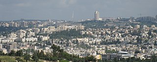
Jerusalem is a city in Western Asia, on a plateau in the Judaean Mountains between the Mediterranean and the Dead Sea. It is one of the oldest cities in the world, and is considered holy to the three major Abrahamic religions—Judaism, Christianity, and Islam. Both Israelis and Palestinians claim Jerusalem as their capital; Israel maintains its primary governmental institutions there, and the State of Palestine ultimately foresees it as its seat of power. Neither claim, however, is widely recognized internationally.
The Holy Land is an area roughly located between the Mediterranean Sea and the Eastern Bank of the Jordan River, traditionally synonymous both with the biblical Land of Israel and with the region of Palestine. The term "Holy Land" usually refers to a territory roughly corresponding to the modern State of Israel and the Palestinian territories. Jews, Christians, and Muslims regard it as holy.

The 2000 Camp David Summit was a summit meeting at Camp David between United States president Bill Clinton, Israeli prime minister Ehud Barak and Palestinian Authority chairman Yasser Arafat. The summit took place between 11 and 25 July 2000 and was an effort to end the Israeli–Palestinian conflict. The summit ended without an agreement.

The Old City of Jerusalem is a 0.9-square-kilometre (0.35 sq mi) walled area in East Jerusalem.

Mount Scopus is a mountain in northeast Jerusalem.

Tel Dor or Tell el-Burj, also Khirbet el-Burj in Arabic, is an archaeological site located on the Israeli coastal plain of the Mediterranean Sea next to modern moshav Dor, about 30 kilometers (19 mi) south of Haifa, and 2.5 kilometers (1.6 mi) west of Hadera. Lying on a small headland at the north side of a protected inlet, it is identified with D-jr of Egyptian sources, Biblical Dor, and with Dor/Dora of Greek and Roman sources.
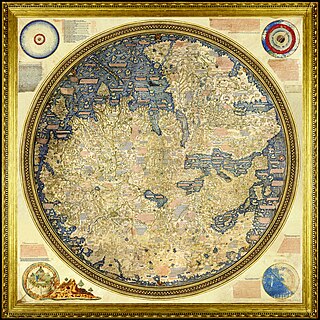
The Fra Mauro map is a map of the world made around 1450 by the Italian (Venetian) cartographer Fra Mauro, which is “considered the greatest memorial of medieval cartography." It is a circular planisphere drawn on parchment and set in a wooden frame that measures over two by two meters. Including Asia, the Indian Ocean, Africa, Europe, and the Atlantic, it is oriented with south at the top. The map is usually on display in the Biblioteca Nazionale Marciana in Venice in Italy.

Jaffa Gate is one of the seven main open gates of the Old City of Jerusalem.

The Israel National Trail is a hiking trail that crosses the entire length of the country of Israel, with its northern end at Kibbutz Kfar Giladi, near the Lebanese border in the far north of the country, extending to Eilat at the southernmost tip of Israel on the Red Sea, with a total length of 1,040 km (650 mi). The trail was inaugurated in 1995.

Tourism in Israel is one of the country's major sources of income, with a record 4.55 million tourist arrivals in 2019. Tourism contributed NIS 20 billion to the Israeli economy in 2017, making it an all-time record. Israel offers a plethora of historical and religious sites, beach resorts, natural sites, archaeological tourism, heritage tourism, adventure tourism, and ecotourism. For practical reasons, this article also covers tourism in the Israeli-occupied West Bank and the occupied Golan Heights, since it is closely interconnected with the mass tourism in Israel.

Mampsis or Memphis, today Mamshit, Arabic Kurnub, is a former Nabataean caravan stop and Byzantine city. In the Nabataean period, Mampsis was an important station on the Incense Road, connecting Southern Arabia through Edom, the Arabah and Ma'ale Akrabim, to the Mediterranean ports, as well as to Jerusalem via Beersheba and Hebron. The city covers 10 acres (40,000 m2) and is the smallest but best restored ancient city in the Negev Desert. The once-luxurious houses feature unusual architecture not found in any other Nabataean city.
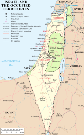
The modern borders of Israel exist as the result both of past wars and of diplomatic agreements between the State of Israel and its neighbours, as well as an effect of the agreements among colonial powers ruling in the region before Israel's creation. Only two of Israel's five total potential land borders are internationally recognized and uncontested, while the other three remain disputed; the majority of its border disputes are rooted in territorial changes that came about as a result of the 1967 Arab–Israeli War, which saw Israel occupy large swathes of territory from its rivals. Israel's two formally recognized and confirmed borders exist with Egypt and Jordan since the 1979 Egypt–Israel peace treaty and the 1994 Israel–Jordan peace treaty, while its borders with Syria, Lebanon and the Palestinian territories remain internationally recognized as contested.
The Clinton Parameters were guidelines for a permanent status agreement to resolve the Israeli–Palestinian conflict, proposed during the final weeks of the Presidential transition from Bill Clinton to George W. Bush.
The Land of Israel is the traditional Jewish name for an area of the Southern Levant. Related biblical, religious and historical English terms include the Land of Canaan, the Promised Land, the Holy Land, and Palestine. The definitions of the limits of this territory vary between passages in the Hebrew Bible, with specific mentions in Genesis 15, Exodus 23, Numbers 34 and Ezekiel 47. Nine times elsewhere in the Bible, the settled land is referred as "from Dan to Beersheba", and three times it is referred as "from the entrance of Hamath unto the brook of Egypt".
De-Pierre Map is an ancient map of the city of Jerusalem which was drawn by and signed in Latin : De Pierre Eques SSmi Sepulchri in 1728. De Pierre a French pilgrim an Equestrian Knight of the Holy Sepulchre.

The John Speed map of Canaan, formally titled "Canaan as it was possessed both in Abraham and Israels dayes with the stations and bordering nations," is an ancient wall map of the Land of Israel drawn by the English historian and cartographer John Speed in 1595. It is the first map to be drawn by Speed. Today the only copy of the map is found within the Eran Laor maps collection in the National Library of Israel in Jerusalem.

The Bünting Clover Leaf Map, also known as The World in a Cloverleaf, is a historic mappa mundi drawn by the German Protestant pastor, theologian, and cartographer Heinrich Bünting. The map was published in his book Itinerarium Sacrae Scripturae in 1581.
