Podolia

Last updated
Podolia
Поділля
Podillia
Stara fortetsia.jpg
Vinnitsia, Monastir kaputsiniv.jpg
Vid na Zalishchiki ta riku Dnister.jpg
Palac tu 07.jpg
Alex K Podolia.svg
Ukraine-Podiliya.png
Podolia (yellow) in modern Ukraine
Country Ukraine, Moldova
Region West Ukraine, Central Ukraine
Historical capital Kamianets-Podilskyi
Largest city Vinnytsia
Parts Ternopil Oblast, Khmelnytskyi Oblast, Vinnytsia Oblast, Odesa Oblast, Cherkasy Oblast
Time zone UTC+2 (EET)
  Summer (DST) UTC+3 (EEST)

Podolia or Podillia [lower-alpha 1] is a historic region in Eastern Europe, located in the west-central and south-western parts of Ukraine and in northeastern Moldova (i.e. northern Transnistria).

Contents

Podolia is bordered by the Dniester River and the Eastern Bug River. Covering an area of 40,000 square kilometres (15,000 sq mi), it features an elongated plateau and fertile agricultural land. Its main rivers are the Dniester and the Southern Bug, which serve as important trade channels. Podolia is known for its cherries, mulberries, melons, gourds, and cucumbers.

The region has a rich history, dating back to the Neolithic period, with various tribes and civilizations occupying it over time. It became part of the Kingdom of Galicia–Volhynia, the Golden Horde, the Kingdom of Poland, the Grand Duchy of Lithuania, the Ottoman Empire, the Austrian Habsburg monarchy, and the Russian Empire. In the 20th century, Podolia underwent various political changes, with both Poland and the Soviet Union controlling parts of it at different times.

Podolian culture is renowned for its folk icon-painting tradition, with red, green, and yellow colors dominating the art. Collections of these iconic works can be found in the Vinnytsya Art Museum and the Museum of Ukrainian Home Icons in Radomysl Castle.

Etymology

Maps title reads Podolian Voivodeship, part of Ukraine Ukraine. Podolia Palatinatus 1648.jpg
Maps title reads Podolian Voivodeship, part of Ukraine

The name derives from Proto-Slavic po 'by, next to, along' and dolъ 'valley, lowland' [1] [2] (cf. English dale, German Tal). [3]

Geography

The area is part of the vast East European Plain, confined by the Dniester River and the Carpathian arc in the southwest. It comprises an area of about 40,000 km2 (15,000 sq mi), extending for 320 km (200 mi) from northwest to southeast on the left bank of the Dniester. In the same direction run two ranges of relatively low hills, separated by the Southern Bug. The Podolian Upland, an elongated, up to 472 ft (144 m) high plateau stretches from the Western and Southern Bug rivers to the Dniester, and includes mountainous regions with canyon-like fluvial valleys.

Podolia lies east of historic Red Ruthenia, i.e. the eastern half of Galicia, beyond the Seret River, a tributary of the Dniester. In the northwest, it borders on Volhynia. It is largely made up of the present-day Ukrainian Vinnytsia Oblast and southern and central Khmelnytskyi Oblast. The Podolian lands also include parts of the adjacent Ternopil Oblast in the west and Kyiv Oblast in the northeast. In the east it consists of the neighbouring parts of Cherkasy, Kirovohrad and Odesa Oblasts, as well as the northern half of Transnistria.

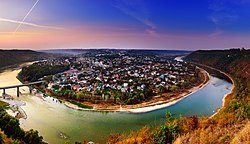
Two large rivers, with numerous tributaries, drain the region: the Dniester, which forms its boundary with Moldova and is navigable throughout its length, and the Southern Bug, which flows almost parallel to the former in a higher, sometimes swampy, valley, interrupted in several places by rapids. The Dniester forms an important channel for trade in the areas of Mohyliv-Podilskyi, Zhvanets, and other Podolian river ports.

In Podolia, 'black earth' ( chernozem ) soil predominates, making it a very fertile agricultural area. Marshes occur only beside the Bug. A moderate climate predominates, with average temperatures at Kamianets-Podilskyi of 9 °C (−4 °C in January, 20 °C in July).

Russian-ruled Podolia in 1906 had an estimated population of 3,543,700, consisting chiefly of Ukrainians. Significant minorities included Poles and Jews, as well as 50,000 Romanians, some Germans, and some Armenians.

The chief settlements include Kamianets-Podilskyi, the traditional capital, Vinnytsia, Khmelnytskyi, Rîbnița, Mohyliv-Podilskyi, Haisyn, Balta, Bar, Camenca, Yampil, Bratslav, and Letychiv.

Podolia is known for its cherries, mulberries, melons, gourds, and cucumbers.

History

Early history

The region has had human inhabitants since at least the beginning of the Neolithic period. Herodotus mentions it as the seat of the Graeco-Scythian Alazones and possibly the Neuri. Subsequently, the Dacians and the Getae arrived. The Romans left traces of their rule in Trajan's Wall, which stretches through the modern districts of Kamianets-Podilskyi, Nova Ushytsia, and Khmelnytskyi.

During the Migration Period, many peoples passed through this territory or settled within it for some time, leaving numerous traces in archaeological remains. Nestor in the Primary Chronicle mentions four apparently Slavic tribes: the Buzhans and Dulebes along the Southern Bug River, and the Tivertsi and Ulichs along the Dniester. The Avars invaded in the 7th century. Later. the Bolokhoveni occupied the same territory in the 13th century.

Prince Oleg extended his rule over this territory known as the Ponizie, or "lowlands". These lowlands later became a part of the principalities of Volhynia, Kiev, and Galicia. In the 13th century, Bakota served as its political and administrative centre.

Lithuanian and Polish rule

During the 13th century, the Mongols plundered Ponizie; Algirdas, Grand Duke of Lithuania, freed it from their rule following his victory against the Golden Horde in the Battle of Blue Waters of 1362, annexing it to Lithuania under the name of Podolia, which has the same meaning as Ponizie, and in 1366 western Podolia with Kamieniec Podolski passed under Polish sovereignty. In 1375, the Roman Catholic Diocese of Kamianets-Podilskyi was founded. Polish colonisation began in the 14th century.[ citation needed ]

Map of Podolia from 1769 Podole.jpg
Map of Podolia from 1769

After the death of the Grand Duke of Lithuania Vytautas in 1430, Podolia was incorporated into Podolian Voivodeship of the Kingdom of Poland, with the exception of its eastern part, the Bracław Voivodeship, which remained with Lithuania, both forming part of the Polish–Lithuanian union. With the Union of Lublin of 1569, eastern Podolia passed from Lithuania to Poland with the Polish–Lithuanian Commonwealth. The Kamieniec Podolski Fortress was nicknamed the "gateway to Poland", [4] whereas the city of Kamieniec Podolski itself as one of Poland's major cities enjoyed voting rights during the royal election period. [5] Podolia was invaded several times by the Crimean Tatars and Turks, and during the Deluge, also by Transylvanians and Russians, with notable Polish victories at Udycz (1606), Czarny Ostrów (1657), Uścieczko (1694).

From 1672, Podolia became part of the Ottoman Empire, when and where it was known as Podolia Eyalet. During this time, it was a province, with its center being Kamaniçe, and was divided into the sanjaks of Kamaniçe, Bar, Mejibuji and Yazlovets (Yazlofça). It returned to Poland in 1699 with the Treaty of Karlowitz.

The region was the site of two notorious massacres, the Batoh massacre of 1652, in which several thousand Poles were murdered by the Cossacks, and the Massacre of Uman of 1768, in which several thousand Poles, Jews and Uniates were murdered by haidamaks.

In 1768, the Bar Confederation was formed by the Poles, including Casimir Pulaski in Bar in Podolia. Podolia remained part of the Polish–Lithuanian Commonwealth until its Partitions of Poland in 1772 and 1793, when the Austrian and Russian Empires annexed the western and eastern parts respectively.

Russian and Austrian rule

Podolians, before 1878 J.H. 1 Podolia.jpg
Podolians, before 1878

From 1793 to 1917, part of the region was the Podolia Governorate in southwestern Russia bordering with Austria across the Zbruch River and with Bessarabia across the Dniester. Its area was 36,910 km2 (14,251 sq mi).

In 1772 First Partition of Poland, the Austrian Habsburgs had taken control of a small part of Podolia west of the Zbruch River (sometimes also called "Southern Podolia") around Borschiv, in what is today Ternopil Oblast. At this time, Emperor Joseph II toured the area, was impressed by the fertility of the soil, and was optimistic about its future prospects. Poland disappeared as a state in a third partition in 1795 but the Polish gentry continued to maintain local control in both eastern and western Podolia over a peasant population which was primarily ethnically Ukrainian whose similarity to the other East Slavs already subject to the Habsburg monarchy was showcased in a 1772 book by Adam F. Kollár and was used as an argument in favor of annexation by the Habsburgs. [6] The Ternopil (Tarnopol) region of western Podolia was briefly taken by Russia in 1809 but reverted to Austrian rule in 1815. Within the Austrian Empire, western Podolia was part of the Kingdom of Galicia and Lodomeria which, in 1867 with the formation of Austria-Hungary, became an ethnic Pole-administered autonomous unit under the Austrian crown. At the end of the nineteenth century and the beginning of the twentieth, Austrian Podolia witnessed a large-scale emigration of its peasant population to western Canada.

Several battles of the Polish uprisings of 1809, 1830–1831 and 1863–1864 were fought in Podolia.

Medieval fortress in Letychiv Letychiv 6.jpg
Medieval fortress in Letychiv

As to the Jewish community in Podolia, the Haskalah or Jewish Enlightenment reached it in the 19th century, introduced by Jews from Western Europe. Says I A. Bar-Levy (Weissman), author of the "Yizkor Book" for Podolia: "It brought an end to the cultural separation of Jews from the surrounding world. Jews began to learn modern sciences and languages, read world literature and participate in the cultural life of the nations among whom they lived." [7] Just as was the case in other areas of former Poland, Jews started to learn the language of the country they lived in and to write about secular subjects. The writers of the Haskalah in Podolia included: the forerunner Isaac Satanow (1733–1805), Menachim Mendel Lapin, author and translator, Ben-Ami (Mordecai Rabinowitz), who wrote in Russian, and many others. [7]

Between Poland and the Soviet Union

Zaleszczyki in then Polish western Podolia before 1939 Zaleszczyki. Widok ogolny.jpg
Zaleszczyki in then Polish western Podolia before 1939

With the collapse of Austria-Hungary following World War I in November 1918, western Podolia was included in the West Ukrainian People's Republic, but came under Polish control in 1919 which was confirmed in the Poland–Ukrainian People's Republic agreement in April 1920. Podolia was briefly occupied in 1920 by Soviets during the course of the Polish–Soviet War. At same war, Poland briefly occupied eastern Podolia in 1919 and again in 1920. After the Peace of Riga the Polish control of western Podolia was recognized by the USSR. USSR retained eastern Podalia. There were pogroms during this period.

In Poland from 1921 to 1939, western Podolia was part of the Tarnopol Voivodeship. Eastern Podolia remained in the Ukrainian SSR and between 1922 and 1940, in the southwestern part, the Moldavian Autonomous Soviet Socialist Republic was created.

In 1927 there was a massive uprising of peasants and factory workers in Mohyliv-Podilskyi, Kamianets-Podilskyi, Tiraspol and other cities of southern Ukrainian SSR against Soviet authorities. Troops from Moscow were sent to the region and suppressed the unrest, causing around 4000 deaths, according to US correspondents sent to report about the insurrection, which was at the time completely denied by the Kremlin official press. [8]

In 1939 after the signing of the Molotov–Ribbentrop Pact between Nazi Germany and the Soviet Union and the Soviet invasion of Poland on September 17, 1939, the area became part of Soviet Ukraine. Many local inhabitants were deported to labour camps.[ citation needed ] In January 1940, the Czortków uprising, an unsuccessful Polish uprising against Soviet occupiers, took place in pre-war Polish Podolia. Following German invasion of the Soviet Union in 1941, most of Podolia was occupied by Nazi Germany and incorporated into the Reichskommissariat Ukraine. The area of Podolia between the Southern Bug below Vinnytsia and the Dniester was occupied by Axis Romania as part of Transnistria.

Starting in July 1941, the Jewish inhabitants were subjected to mass extermination by shooting in a German campaign carried out by four Einsatzgruppen ("operational groups") specially organized for the purpose. Reliable estimates including German, Soviet, and local records indicate that upwards of 1.6 million, perhaps as many as 2 million, Jews were murdered in this fashion. Most were buried in mass graves,[ citation needed ] but there were also instances of communities being forced en masse into community buildings or synagogues that were then burnt,[ citation needed ] or herded into local mines that were subsequently dynamited.[ citation needed ]

The Germans operated the Stalag 310, Stalag 329, Stalag 349 and Stalag 355 prisoner-of-war camps in Podolia. [9]

In 1944 the Soviets re-occupied Podolia and in 1945, when Poland's eastern border was formally realigned along the Curzon line, the whole of Podolia remained in the Ukrainian and Moldavian Soviet Socialist Republics. Most remaining Poles and Jews fled or were expelled to the People's Republic of Poland.

Culture

The Podillia's folk icon-painting tradition is well known in Ukraine. Its manifestation is long home iconostases painted on canvas at the end of the 19th to the beginning of the 20th centuries. Red, green and yellow colours prevail, the faces of the saints are a little bit longer, their eyes almond-like. On these iconostases, the most venerated family saints were painted. The collections of Podillya's folk iconostases are possessed by Vinnytsya Art Museum and The Museum of Ukrainian Home Icons in the Radomysl Castle. [10]

Notable people

Notes

  1. Ukrainian: Поділля, romanized: Podillia, IPA: [poˈd⁽ʲ⁾ilʲːɐ] ; Romanian: Podolia; Russian: Подолье, romanized: Podolye; Polish: Podole; German: Podolien; Lithuanian: Podolė; Belarusian: Падолле, romanized: Padollie; Yiddish: פּאָדאָליע, romanized: Podolie.

Related Research Articles

<span class="mw-page-title-main">Tourism in Ukraine</span>

Ukraine used to attract more than 20 million foreign citizens every year. But since 2014 this has lowered to about 10 million. Visitors primarily come from Eastern Europe, but also from Western Europe, as well as Turkey and Israel.

<span class="mw-page-title-main">Volhynia</span> Historical region in Central and Eastern Europe

Volhynia is a historic region in Central and Eastern Europe, between southeastern Poland, southwestern Belarus, and northwestern Ukraine. The borders of the region are not clearly defined, but in Ukraine it is roughly equivalent to Volyn and Rivne Oblasts; the territory that still carries the name is Volyn Oblast.

<span class="mw-page-title-main">Khmelnytskyi Oblast</span> Oblast (region) of Ukraine

Khmelnytskyi Oblast, also known as Khmelnychchyna, is an oblast (province) in western Ukraine covering portions of the historical regions of western Podolia and southern Volhynia. The administrative center of the oblast is the city of Khmelnytskyi.

<span class="mw-page-title-main">Ternopil Oblast</span> Region of Ukraine

Ternopil Oblast, also referred to as Ternopilshchyna or Ternopillia, is an oblast (province) of Ukraine. Its administrative center is Ternopil, through which flows the Seret, a tributary of the Dniester. Population: 1,021,713.

<span class="mw-page-title-main">Vinnytsia Oblast</span> Oblast (region) of Ukraine

Vinnytsia Oblast, also referred to as Vinnychchyna, is an oblast in central Ukraine. Its administrative center is Vinnytsia. The oblast has a population of 1,509,515.

<span class="mw-page-title-main">Khmelnytskyi</span> City and administrative center of Khmelnytskyi Oblast, Ukraine

Khmelnytskyi is a city in western Ukraine. Located on the Southern Bug, it serves as the administrative centre of Khmelnytskyi Oblast as well as Khmelnytskyi Raion within the oblast. With a population of 274,452, Khmelnytskyi is the second-largest city in the historical region of Podolia, after Vinnytsia.

<span class="mw-page-title-main">Kamianets-Podilskyi</span> City in Khmelnytskyi Oblast, Ukraine

Kamianets-Podilskyi is a city on the Smotrych River in western Ukraine, to the north-east of Chernivtsi. Formerly the administrative center of Khmelnytskyi Oblast, the city is now the administrative center of Kamianets-Podilskyi Raion within the oblast. It hosts the administration of Kamianets-Podilskyi urban hromada. Population: 96,896.

<span class="mw-page-title-main">Shepetivka</span> City in Khmelnytskyi Oblast, Ukraine

Shepetivka is a city located on the Huska River in Khmelnytskyi Oblast (province) in western Ukraine. Shepetivka is the administrative center of Shepetivka Raion (district). It hosts the administration of Shepetivka urban hromada, one of the hromadas of Ukraine. Population: 40,299.

<span class="mw-page-title-main">Zbruch</span> River in Ukraine

The Zbruch is a river in Western Ukraine, a left tributary of the Dniester.

<span class="mw-page-title-main">Western Ukraine</span> Western territories of Ukraine

Western Ukraine or West Ukraine refers to the western territories of Ukraine. There is no universally accepted definition of the territory's boundaries, but the contemporary Ukrainian administrative regions (oblasts) of Chernivtsi, Ivano-Frankivsk, Lviv, Ternopil and Zakarpattia are typically included. In addition, Volyn and Rivne oblasts are also usually included. It is less common to include Zhytomyr Oblast and Podolia. It includes several historical regions such as Carpathian Ruthenia, Halychyna including Pokuttia, most of Volhynia, northern Bukovina and the Hertsa region, and Podolia. Western Ukraine is sometimes considered to include areas of eastern Volhynia, Podolia, and the small northern portion of Bessarabia.

<span class="mw-page-title-main">Podolia Governorate</span> 1793–1925 unit of Russia

Podolia Governorate was an administrative-territorial unit (guberniya) of the Southwestern Krai of the Russian Empire. It bordered Volhynian Governorate to the north, Kiev Governorate to the east, Kherson Governorate to the southeast, Bessarabia Governorate to the south, and Austria to the west. Its administrative centre was Kamenets-Podolsky (Kamianets-Podilskyi), which later moved to Vinnitsa (Vinnytsia). The governorate covered areas of Ukraine's partially Khmelnytskyi and most of Vinnytsia Oblasts, along with the fractionally recognised state of Transnistria.

<span class="mw-page-title-main">Mohyliv-Podilskyi</span> City in Vinnytsia Oblast, Ukraine

Mohyliv-Podilskyi is a city in Vinnytsia Oblast, Ukraine. It serves as the administrative center of Mohyliv-Podilskyi Raion within the oblast. It is located in the historic region of Podolia, on the border with Bessarabia, Moldova, along the left bank of the Dniester River. On the opposite side of the river lies the Moldovan town of Otaci, and the two municipalities are connected to each other by a bridge. Population: 29,925.

<span class="mw-page-title-main">Dunaivtsi</span> City in Khmelnytskyi Oblast, Ukraine

Dunaivtsi is a city in Kamianets-Podilskyi Raion, Khmelnytskyi Oblast, Ukraine. It is located on the river Ternavka, 22 km away from the railway station Dunaivtsi and 68 km from the Khmelnytskyi. Reinforcement plant, repair and engineering works and butter-processing plant are located in the city. The city also houses a control center of the State Space Agency of Ukraine. Dunaivtsi hosts the administration of Dunaivtsi urban hromada, one of the hromadas of Ukraine. Current population is 15,707.

Tomashpil is a rural settlement in the eastern Podolia, specifically in Tulchyn Raion of Vinnytsia Oblast in central Ukraine. Tomashpil is situated on the banks of the Rusava River. Tomashpil is the administrative district of Tomashpil Raion (780 km2), home to 40.608 people scattered over the town and 30 villages around. Population: 5,276

<span class="mw-page-title-main">Kamianets-Podilskyi Castle</span> Castle and fortress in Kamianets-Podilskyi, Ukraine

Kamianets-Podilskyi Castle is a former Ruthenian-Lithuanian castle and a later three-part Polish fortress located in the historic city of Kamianets-Podilskyi, Ukraine, in the historic region of Podilia in the western part of the country. Its name is attributed to the root word 'kamin', from the Slavic word for 'stone'.

Dzyhivka is one of the oldest villages in central Ukraine, of Mohyliv-Podilskyi Raion, Vinnytsia Oblast. It is located in the historical region of Podolia, on the Korytna Stream that flows into the Rusava River, a tributary of the Dniester River.

<span class="mw-page-title-main">Kamianets-Podilskyi Raion</span> Subdivision of Khmelnytskyi Oblast, Ukraine

Kamianets-Podilskyi Raion is one of the three administrative raions (district) of Khmelnytskyi Oblast in western Ukraine. Its administrative center is located in the city of Kamianets-Podilskyi. Population: 279,789.

Kamianets Okruha was one of the administrative units of the Ukrainian Soviet Socialist Republic from 1923–1930 and again from 1935–1937.

<span class="mw-page-title-main">Nova Ushytsia</span> Rural locality in Khmelnytskyi Oblast, Ukraine

Nova Ushytsia is a rural settlement in Kamianets-Podilskyi Raion, Khmelnytskyi Oblast, western Ukraine. It hosts the administration of Nova Ushytsia settlement hromada, one of the hromadas of Ukraine. The settlement's population was 4,557 as of the 2001 Ukrainian Census. Current population: 3,880.

<span class="mw-page-title-main">Murovani Kurylivtsi</span> Rural locality in Vinnytsia Oblast, Ukraine

Murovani Kurylivtsi is a rural settlement in the southwestern part of Vinnytsia Oblast, Ukraine. It was formerly the administrative center of Murovani Kurylivtsi Raion, but is now administered within Mohyliv-Podilskyi Raion. Murovani Kurylivtsi is located on the banks of the Zhvan River, a left tributary of the Dniester River, in the historic region of Podolia. Population: 5,632

References

  1. Кобилянський, Броніслав Володимирович (1960). Діалект і літературна мова: східнокарпатський і покутський діалекти, їх походження і відношення до української літературної мови. Київ: Радянська школа. p. 154.
  2. Ярослав Романович Дашкевич (1990). "Поділля: виникнення і значення назви". VIII Подільська історико-краєзнавча конференція: Тези доповідей: Секція історії дожовтневого періоду. Кам'янець-Подільський. pp. 58–60.{{cite book}}: CS1 maint: location missing publisher (link)
  3. Трубачев, Олег Николаевич (1978). Этимологический словарь славянских языков. Праславянский лексический фонд. Выпуск 5 (*dělo—*deržьlь) (PDF). Москва: Наука. p. 50. Retrieved September 1, 2024.
  4. Słownik geograficzny Królestwa Polskiego i innych krajów słowiańskich, Tom III (in Polish). Warszawa. 1882. p. 748.{{cite book}}: CS1 maint: location missing publisher (link)
  5. Polska encyklopedja szlachecka, Tom I (in Polish). Warszawa: Wydawnictwo Instytutu Kultury Historycznej. 1935. p. 42.
  6. Joachim Bahlcke, Ungarischer Episkopat und österreichische Monarchie: Von einer Partnerschaft zur Konfrontation (1686–1790). 2005.
  7. 1 2 Bar-Levy, I. A. (1966). Blatman, Leon S. (ed.). 'Kamenetz-Podolsk': A Memorial to a Jewish Community Annihilated by the Nazis in 1941. New York: The Sponsors of the Kamenetz-Podolsk Memorial Book. p. 14 via Princeton University Press.
  8. Disorder in the Ukraine?, Time , December 12, 1927
  9. Megargee, Geoffrey P.; Overmans, Rüdiger; Vogt, Wolfgang (2022). The United States Holocaust Memorial Museum Encyclopedia of Camps and Ghettos 1933–1945. Volume IV. Indiana University Press, United States Holocaust Memorial Museum. pp. 297–298, 325, 350, 358. ISBN   978-0-253-06089-1.
  10. Богомолець. О. "Замок-музей Радомисль на Шляху Королів Via Regia". — Київ, 2013