Yekaterinoslav Governorate

Last updated

Yekaterinoslav Governorate
Екатеринославская губерния
Coats of arms of Yekaterinoslav Governorate.svg
Yekaterinoslav in Russian Empire (1914).svg
Location in the Russian Empire
Country Russian Empire
Established1802
Abolished1925
Capital Yekaterinoslav
Area
  Total63,391.61 km2 (24,475.64 sq mi)
Population
 (1897)
  Total2,113,674 [1] [2]
   Urban
11.40%
   Rural
88.60%

Yekaterinoslav Governorate [lower-alpha 1] was an administrative-territorial unit ( guberniya ) of the Russian Empire, with its capital in Yekaterinoslav. It bordered Poltava Governorate to the north, Don Host Oblast to the east, Sea of Azov to the southeast, Taurida Governorate to the south, and Kherson Governorate to the east, and covered the area of the Luhansk, Donetsk, Dnipropetrovsk, and Zaporizhzhia Oblasts of modern Ukraine.

Contents

Yekaterinoslav Governorate in 1913 Yekaterinoslav Governorate.gif
Yekaterinoslav Governorate in 1913

Location

The government was created in 1802 out of the Yekaterinoslav vice-regency. The governorate bordered to the north with the Kharkov Governorate and Poltava Governorate, to the west and southwest with the Kherson Governorate, to the south with the Taurida Governorate and Sea of Azov, and to the east with Don Host Oblast.

Administrative divisions

The governorate was created in place of Novorossiysk Governorate in 1802 and encompassed a huge area of the southern Ukraine. Officially, the new governorate was created as Ekaterinoslav Governorate in 1802 and subdivided into the following uyezds with centres in:

County County TownArms of County TownAreaPopulation
(1897 census)
Transliteration name Russian Cyrillic
Aleksandrovsky Александровскій Aleksandrovsk
Coat of arms of Aleksandrovsk (1811).svg
10,015.8 km2
(3,867.1 sq mi)
271,678
Bakhmutsky Бахмутскій Bakhmut
Old Coat of Arms of Artemivsk (Donetsk Oblast).svg
9,224.8 km2
(3,561.7 sq mi)
332,478
Verkhnedneprovsky Верхнеднѣпровскій Verkhnedniprovsk
Coat of Arms of Verkhnodniprovsk.svg
6,862.3 km2
(2,649.5 sq mi)
211,674
Yekaterinoslavsky Екатеринославскій Yekaterinoslav
Coat of arms of Yekaterinoslav 1859.svg
7,858 km2
(3,034 sq mi)
357,207
Mariupolsky Маріупольскій Mariupol
Coat of arms of Mariupol 1866.svg
8,989.2 km2
(3,470.7 sq mi)
254,056
Novomoskovsky Невомосковскій Novomoskovsk
Coat of arms Novomoskovsk Kene.png
6,532 km2
(2,522 sq mi)
260,368
Pavlogradsky Павлоградскій Pavlograd
Pavlgrad-1862-Kene.gif
8,815.7 km2
(3,403.8 sq mi)
251,460
Slavyanoserbsky Славяносербскій Lugansk
Coat of arms of Luhansk 1903.svg
5,089 km2
(1,965 sq mi)
174,753
  1. Taganrog city (Таганрог) 1802–1887
  2. Rostov upon Don city 1802–1887
Ukraine's modern border superimposed on the administrative division of 1900 for both the Russian and the Austro-Hungarian Empires. The borders of the uyezds can be seen from this map 1900 Ukr adm podil.png
Ukraine's modern border superimposed on the administrative division of 1900 for both the Russian and the Austro-Hungarian Empires. The borders of the uyezds can be seen from this map

Changes in Russian Empire

Ukraine

South Russia

Soviet Ukraine

Okrugs

List of okruhas of Ukraine upon the dissolution of the Governorate:

  1. Yekaterinoslav
  2. Zaporizhia
  3. Kryvyi Rih
  4. Melitopol
  5. Pavlohrad

Demographics

The governorate's population, a majority of peasants, was 662,000 in 1811, 902,400 in 1851, 1,204,800 in 1863, and 1,792,800 in 1885. From the second half of the 19th century, with the founding of Yuzovka (Donetsk), the governorate became the coal-mining and metallurgical center of the then Ukraine, incorporating the Dnieper Industrial Region and the Donbass (Donets Basin).

Its population increased to 2,113,674 by 1897. The nationalities within the governorate were Ukrainians68.9%, Russians17.3%, Jews (4.7%), Germans (3.8%), Greeks (2.3%), and Tatars (0.8%). In 1924, the governorate had 3,424,100 (13.6% urban) inhabitants, living in 5,165 settlements, 36 of them being cities and urban-type settlements. The largest social class was that of workers (about 25%).

Principal cities

An old postcard depicting Yekaterinoslav, the governorate's capital at the time. Ekaterinoslav.PNG
An old postcard depicting Yekaterinoslav, the governorate's capital at the time.

The data is taken from demoscope.ru. Here is also the most common language composition.

From the turn of the 19th century until 1887 city of Rostov-na-Donu and all the Taganrog uyezd were part of the governorate, but before the census of 1897 took place they were transferred to the Don oblast. Note that the biggest city of the guberniya was the city of Rostov-na-Donu while Taganrog was not much smaller and the third in size. Here is the data on them:

Language

Native languageYekaterinoslav Governorate
Екатеринославская губерния [2]
For each uyezd (district)
Yekaterinoslav
Екатеринославский уезд [4]
Pavlograd
Павлоградский уезд [5]
Bakhmut
Бахмутский уезд [6]
Novomoskovsk
Новомосковский уезд [7]
Mariupol
Мариупольский уезд [8]
Alexandrovsk
Александровский уезд [9]
Slavyanoserbsk
Славяносербский уезд [10]
Verkhnedneprovsk
Верхнеднепровский уезд [11]
Number%NumberNumberNumberNumberNumberNumberNumberNumber
Total2,113,674100%357,207251,460332,478260,368254,056271,678174,753211,674
Great Russian (Russian) 364,97417.27%75,19036,164103,7029,62835,69115,44579,2819,873
Little Russian (Ukrainian) 1,456,26968.90%198,982200,434193,510242,737117,206224,12288,218191,160
White Russian (Belarusian) 14,0520.66%4,0335052,4681961,6973,3531,564236
Polish 12,3650.59%7,9335532,000316528293511231
German 80,9793.83%20,6095,80612,6463,45219,10414,0148964,452
French 9080.04%197845150461812216
Italian 1460.01%2113703914259
Romanian and Moldovan 9,1750.43%1,771296,371095283968
English 3690.02%14128404121314
Greek 48,7402.31%19338142948,29045149
Jewish 99,1524.69%46,4417,3639,4573,63510,29113,8862,6315,448
Tatar 17,2530.82%868255346715,47212815126
Turkish 5,5550.26%168152095,3171448
Roma (Gypsy) 1,2930.06%1031722552722120317790
Other1,8880.09%51971655281647725123
Unidentified5560.03%165451342954625611

Religion

Governors

General-Governors
Governors

Chairmen of the Governorate

Revkoms
Ispolkom

Chekists

As an independent governmental organization
Membership ticket of Committees of Poor Peasants, Oleksandriia district, 1924 (for Kyrylo Ivanovych Turbaivskyi) Chlens'kii kvitok organizatsiyi nezamozhnikh selian 02.jpg
Membership ticket of Committees of Poor Peasants, Oleksandriia district, 1924 (for Kyrylo Ivanovych Turbaivskyi)
As part of the State Political Directorate (GPU)

Notable people

See also

Notes

    • Russian: Екатериносла́вская губе́рния, pre-1918: Екатериносла́вская губе́рнія, romanized: Yekaterinoslávskaya gubérniya
    • Ukrainian: Катериносла́вська губе́рнія, romanized: Katerynoslávsʼka hubérniia
    • Sometimes in English as well: Ekaterinoslav Governorate
    • Also known as Katerynoslavshchyna, (Ukrainian: Катеринославщина; Russian: Екатеринославщина, romanized: Yekaterinoslavshchina)

Related Research Articles

<span class="mw-page-title-main">Minsk Governorate</span> 1793–1921 unit of Russia

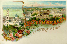
Minsk Governorate was an administrative-territorial unit (guberniya) of the Russian Empire, with its capital in Minsk. It was created from the land acquired in the partitions of Poland and existed from 1793 until 1921. Its territory covered the majority of modern-day Belarus.

<span class="mw-page-title-main">Narew, Podlaskie Voivodeship</span> Village in Podlaskie Voivodeship, Poland

Narew is a village in Hajnówka County, Podlaskie Voivodeship, in north-eastern Poland. It is the seat of the gmina called Gmina Narew. It lies approximately 21 kilometres (13 mi) north of Hajnówka and 33 km (21 mi) south-east of the regional capital Białystok.

<span class="mw-page-title-main">Wierland County</span> Uyezd in Estonia Governorate, Russian Empire

The 
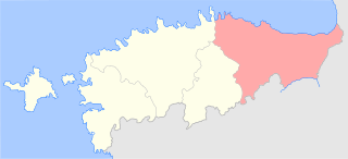
Wierland County was one of the four counties of the Russian Empire located in the Governorate of Estonia. It was situated in the eastern part of the governorate. Its capital was Rakvere (Wesenberg). The territory of Kreis Wierland corresponds to most parts of the present-day Ida-Viru and Lääne-Viru counties and a small part of Jõgeva County.

<span class="mw-page-title-main">Wiek County</span> Uyezd in Estonia Governorate, Russian Empire

The 
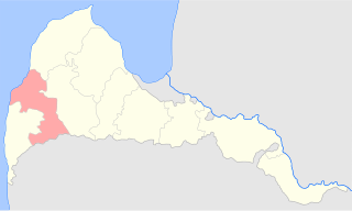
Wiek County was one of the four counties of the Russian Empire located in the Governorate of Estonia. It was situated in the western part of the governorate. Its capital was Haapsalu (Hapsal). The territory of Wiek County corresponds to the present-day Lääne and Hiiu counties, the westernmost part of Rapla County, and a small part of Pärnu County.

<span class="mw-page-title-main">Jerwen County</span> Uyezd in Estonia Governorate, Russian Empire

The Jerwen County was one of the four counties of the Russian Empire located in the Governorate of Estonia. It was situated in the central part of the governorate. Its capital was Paide (Weissenstein). The territory of Kreis Jerwen corresponds to most of the present-day Järva County and small parts of Lääne-Viru and Rapla counties.

<span class="mw-page-title-main">Harrien County</span> Uyezd in Estonia Governorate, Russian Empire

The Harrien County was one of the four counties of the Governorate of Estonia. It was situated in the central part of the governorate. Its capital was Reval (Tallinn), which was the capital of the governorate as well. The territory of Kreis Harrien corresponds to the present-day Harju County and most parts of Rapla County.

<span class="mw-page-title-main">Dobeles apriņķis</span> County of Latvia

Dobeles apriņķis was a historic county of the Courland Governorate and of the Republic of Latvia. Its capital was Dobele (Doblen).

<span class="mw-page-title-main">Bauskas apriņķis</span> County of Latvia

Bauskas apriņķis was a historic county of the Courland Governorate and of the Republic of Latvia. Its capital was Bauska (Bauske).

<span class="mw-page-title-main">Aizputes apriņķis</span> County of Latvia

Aizpute County was a historic county of the Courland Governorate and of the Republic of Latvia. Its capital was Aizpute (Hasenpoth).

<span class="mw-page-title-main">Kuldīgas apriņķis</span> County of Latvia

Kuldīgas apriņķis was a historic county of the Courland Governorate and of the Republic of Latvia. Its capital was Kuldīga (Goldingen).

<span class="mw-page-title-main">Grobiņas apriņķis</span> County of Latvia

Grobiņas apriņķis was a historic county of the Courland Governorate and shortly of the Republic of Latvia. Its capital was Grobiņa (Grobin).

<span class="mw-page-title-main">Talsu apriņķis</span>

Talsu apriņķis was a historic county of the Courland Governorate and of the Republic of Latvia. Its capital was Talsi (Talsen).

<span class="mw-page-title-main">Tukuma apriņķis</span>

Tukuma apriņķis was a historic county of the Courland Governorate and of the Republic of Latvia. Its capital was Tukums (Tuckum).

<span class="mw-page-title-main">Jaunjelgavas apriņķis</span> Uyezd of the Russian Empire

Jaunjelgavas apriņķis was a historic county of the Courland Governorate and of the Republic of Latvia. Its capital was Jaunjelgava (Friedrichstadt).

<span class="mw-page-title-main">Ilūkstes apriņķis</span> County of Latvia

Ilūkstes apriņķis was a historic county of the Courland Governorate and of the Republic of Latvia. Its capital was Ilūkste (Illuxt), but the most populous settlement was Grīva (Griwa-Semgallen) immediately south of Daugavpils (Dünaburg).

<span class="mw-page-title-main">Ventspils apriņķis</span> Historic county of Latvia

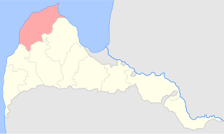
Ventspils County was a historic county of the Courland Governorate and of the Republic of Latvia. Its capital was Ventspils (Windau).

Javad <i>uezd</i> Uezd in Caucasus, Russian Empire

The Javad uezd, known after 1921 as the Salyan uezd, was a county (uezd) within the Baku Governorate of the Russian Empire and then of the Azerbaijan Democratic Republic and Azerbaijan SSR until its formal abolishment in 1929 by the Soviet authorities. The uezd was located in the central part of the governorate, bordering the Geokchay, Shemakha, and Baku uezds to the north, Caspian sea to the east, Lenkoran uezd to the south and Iran to the west. The administrative center of the uezd was the city of Salyan.

<span class="mw-page-title-main">Pavlovsky Uyezd, Voronezh Governorate</span> Subdivision of Voronezh Governorate, Russian Empire

Pavlovsky Uyezd was an uyezd of Voronezh Governorate in the Russian Empire. It was situated in the central part of the governorate. Its administrative centre was Pavlovsk.

Berdyansky Uyezd was one of the subdivisions of the Taurida Governorate of the Russian Empire. Its administrative centre was Berdiansk. Other populous places in the uyezd were Dmytrivka and Tokmak.

<span class="mw-page-title-main">Sudzhansky Uyezd</span> Subdivision of Kursk Governorate, Russian Empire

Sudzhansky Uyezd was one of the subdivisions of Kursk Governorate of the Russian Empire. It was situated in the western part of the governorate. Its administrative centre was Sudzha.

References

  1. Troynitsky, Nikolay (1904). Первая всеобщая перепись населения Российской империи 1897 г. XIII. Екатеринославская губерния [The first general census of the population of the Russian Empire in 1897. 13. Ekaterinoslav Province] (6th ed.). Izdanie Tsentral'nogo statisticheskogo komiteta Ministerstva vnutrennikh del. Archived from the original on 1 December 2022.
  2. 1 2 Екатеринославская губерния – вся[Yekaterinoslav Governorate, all], Первая всеобщая перепись населения Российской Империи 1897 г. Распределение населения по родному языку и уездам 50 губерний Европейской России [The first national census of the Russian Empire in 1897. Distribution of the population by mother tongue and uyezd of 50 provinces of European Russia.], Демоскоп Weekly
  3. Population of Yekaterinoslav
  4. Екатеринославский уезд – весь[Yekaterinoslav Uyezd, all], Первая всеобщая перепись населения Российской Империи 1897 г. Распределение населения по родному языку и уездам 50 губерний Европейской России [The first national census of the Russian Empire in 1897. Distribution of the population by mother tongue and uyezd of 50 provinces of European Russia.], Демоскоп Weekly
  5. Павлоградский уезд – весь[Pavlograd Uyezd, all], Первая всеобщая перепись населения Российской Империи 1897 г. Распределение населения по родному языку и уездам 50 губерний Европейской России [The first national census of the Russian Empire in 1897. Distribution of the population by mother tongue and uyezd of 50 provinces of European Russia.], Демоскоп Weekly
  6. Бахмутский уезд- весь[Bakhmut Uyezd, all], Первая всеобщая перепись населения Российской Империи 1897 г. Распределение населения по родному языку и уездам 50 губерний Европейской России [The first national census of the Russian Empire in 1897. Distribution of the population by mother tongue and uyezd of 50 provinces of European Russia.], Демоскоп Weekly
  7. Новомосковский уезд – весь[Novomoskovsk Uyezd, all], Первая всеобщая перепись населения Российской Империи 1897 г. Распределение населения по родному языку и уездам 50 губерний Европейской России [The first national census of the Russian Empire in 1897. Distribution of the population by mother tongue and uyezd of 50 provinces of European Russia.], Демоскоп Weekly
  8. Мариупольский уезд – весь[Mariupol Uyezd, all], Первая всеобщая перепись населения Российской Империи 1897 г. Распределение населения по родному языку и уездам 50 губерний Европейской России [The first national census of the Russian Empire in 1897. Distribution of the population by mother tongue and uyezd of 50 provinces of European Russia.], Демоскоп Weekly
  9. Александровский уезд – весь[Alexandrovsk Uyezd, all], Первая всеобщая перепись населения Российской Империи 1897 г. Распределение населения по родному языку и уездам 50 губерний Европейской России [The first national census of the Russian Empire in 1897. Distribution of the population by mother tongue and uyezd of 50 provinces of European Russia.], Демоскоп Weekly
  10. Славяносербский уезд – весь[Slavyanoserbsk Uyezd, all], Первая всеобщая перепись населения Российской Империи 1897 г. Распределение населения по родному языку и уездам 50 губерний Европейской России [The first national census of the Russian Empire in 1897. Distribution of the population by mother tongue and uyezd of 50 provinces of European Russia.], Демоскоп Weekly
  11. Верхнеднепровский уезд – весь[Verkhnedneprovsk Uyezd, all], Первая всеобщая перепись населения Российской Империи 1897 г. Распределение населения по родному языку и уездам 50 губерний Европейской России [The first national census of the Russian Empire in 1897. Distribution of the population by mother tongue and uyezd of 50 provinces of European Russia.], Демоскоп Weekly
  12. The first national census of the Russian Empire in 1897, Ed. N.A.Troynitskogo. t.I. The total body of the Empire's first general census of population development results produced by 28 January 1897. St. Petersburg, 1905. Table XII. Population by religions.
    Religion Statistics of 1897 Yekaterinoslav (in Russian)
    Religion Statistics of 1897 Yekaterinoslav in the cities (in Russian)

48°27′00″N34°59′00″E / 48.4500°N 34.9833°E / 48.4500; 34.9833