Kharkov Governorate

Last updated
Kharkov Governorate
Харьковская губерния
Coat of arms of Kharkov Governorate 1887.svg
Kharkov in Russian Empire (1914).svg
Location in the Russian Empire
Country Russian Empire
Established1835
Abolished1925
Capital Kharkov
Area
  Total54,493 km2 (21,040 sq mi)
Population
 (1897)
  Total2,492,316
  Density46/km2 (120/sq mi)
   Urban
14.74%
   Rural
85.26%

Kharkov Governorate [lower-alpha 1] was an administrative-territorial unit ( guberniya ) of the Russian Empire founded in 1835. It embraced the historical region of Sloboda Ukraine. From 1765 to 1780 and from 1796 to 1835 the governorate was called Sloboda Ukraine Governorate. In 1780-1796 there existed the Kharkov Viceroyalty.

Contents

From 1765 to 1780, the Sloboda Ukraine Governorate existed. In 1780, the Kharkov Viceroyalty was established and lasted until 1796. In 1835, the Viceroyalty was again reorganized into the Sloboda-Ukrainian Governorate, and from 1835 onwards, the Kharkov Governorate was formed, which existed until 1925. With each reorganization, the boundaries and administrative structure change significantly. The main state tax implementation, processing, and publishing of statistical information for the Kharkov governorate was the Kharkov Governorate Statistical Committee.

Kharkov Governorate administrative divisions in 1913 Kharkov Governorate (1913).png
Kharkov Governorate administrative divisions in 1913

History

Sloboda Ukraine Governorate (1765–1780)

After the abolition of the Cossack system in Sloboda Ukraine, Sloboda Ukraine Governorate was set up in 1765 on the former territory of the Sloboda Cossack regiments, with its capital in Kharkiv (historically known as Kharkov). The dissolved regiments were Kharkiv Regiment, Sumy Regiment, Okhtyrka Regiment, Izium Regiment, and Ostrogozhsk Regiment. [1]

Kharkov Viceroyalty (1780–1796)

In 1780, Sloboda Ukraine Governorate was dissolved and reorganized into the Kharkov Viceroyalty [1] in accordance with an April 25, 1780 decree signed by Catherine the Great. It was formed of the uezds of Akhtyrsky Uyezd, Belopolsky, Bogodukhovsky Uyezd, Valkovsky, Volchansky Uyezd, Zolochevsky, Izyumsky Uyezd, Krasnokutsky, Lebedinsky Uyezd, Miropolsky, Nedrigailovsky, Sumsky Uyezd, Kharkovsky Uyezd, Khotmyzhsky, and Chuguevsky.

Sloboda Ukraine Governorate (1796–1835)

All viceroyalties of the Russian Empire were abolished in 1797, and replaced again by governorates. [2] As part of this reform, the Kharkov Viceroyalty was abolished in 1797, and the Sloboda Ukraine Governorate was re-established. It contained the former Kharkov Viceroyalty's territory, as well as several uyezds from Voronezh Governorate. [1] It was divided into 10 uezds: Akhtyrsky Uyezd, Bogodukhovsky, Valkovsky, Volchansky Uyezd, Zmievsky, Izyumsky Uyezd, Kupyansky Uyezd, Lebedinsky Uyezd, Sumsky Uyezd, and Kharkovsky Uyezd.

Kharkov Governorate (1835–1925)

Map of Kharkov Governorate in between 1890 and 1906 Kharkov guberniya.jpg
Map of Kharkov Governorate in between 1890 and 1906

In 1835, Sloboda Ukraine Governorate was renamed to Kharkov Governorate. It consisted of eleven uyezds. [3] In the same year, the Kharkov Governorate was incorporated to the Little Russian Governor-General. The Governor-residence General was originally in Poltava but has been in Kharkov since 1837. By 1856, the governorate had grown to 13 counties, and the final administrative division had been established. Kharkov was the seat of the Orthodox Kharkov Diocese and the Kharkov Educational District, as well as the judicial authority for the governorates of Kharkov, Kursk, Voronezh, Oryol, Yekaterinoslav, and Tambov, and the Kharkov Military District administration from 1864 to 1888.[ citation needed ] The governorate's territory was excluded from the Pale of Settlement. Nevertheless, Jews were permitted to visit Kharkov during the fairs. [4]

The newspaper Kharkovskie Gubernskie Vedomosti was first published in 1838. The Zemstvo was founded as part of the Zemstvo reform. On February 21 [ O.S. February 9] 1879, the terrorist Grigory Goldenberg assassinated Governor D. N. Kropotkin. General M. T. Loris-Melikov was appointed temporary governor-general of the Kharkov Governorate on April 7, 1879, and commanding officer of the Kharkov Military District on April 17, the same year.

Kharkov Governorate in 1917 Khar gub 1917 karta.jpg
Kharkov Governorate in 1917

The Izyumsky and Starobelsky uezds of Kharkov Governorate were transferred to the newly established Donetsk Governorate in 1920. Zmiev uezd was split into Zmiev and Chuguevsky uezds in December 1919. The government of the Ukrainian SSR adopted a new system of administrative division of the republic's territory on March 7, 1923, by Decree of the Presidium of the All-Ukrainian Central Executive Committee No. 315 of March 7, 1923. Okrugs and raions replaced uyezds and volosts. Instead of 10 uezds, the governorate was divided into 5 okrugs, as well as 227 volosts divided into 77 raions. Kharkov Governorate was divided into okrugs, according to the new administrative-territorial division system, RaionOkrugGovernorate–Capital: Kharkov (24 raions), Bogodukhovsky (12 raions), Izyumsky (11 raions), Kupyansky (12 raions), and Sumy (16 raions).

In 1924, it had a population of 2,728,400, of whom 20% lived in cities, and only 55% were Ukrainians. [3]

Abolition (1925)

All of the Ukrainian SSR's governorates, including Kharkov, were abolished in June 1925, and the governorate's okrugs were transferred to the Ukrainian SSR's direct subordination (with its capital in Kharkiv). Based on a decision of the 9th All-Ukrainian Congress of Soviets, the All-Ukrainian Central Executive Committee signed a decree on June 3, 1925, establishing a new territorial division throughout the Ukrainian SSR based on the principle of a three-stage system of government (without governorates): OkrugRaion–Capital. [5] Kharkiv Oblast, which contains most of the territory of the former governorate, was formed in 1932. [3]

Demographics

1897 Russian Census

Uyezds of Kharkov Governorate

County County TownArms of County TownAreaPopulation
(1897 census)
Transliteration name Russian Cyrillic
Akhtyrsky Ахтырский Akhtyrka
Akhtyrka COA (Kharkov Governorate) (1781).png
2,778.69 km2
(1,072.86 sq mi)
161,243
Bogodukhovsky Богодуховский Bogodukhov
Bogodukhov COA (Kharkov Governorate) (1781).gif
3,224.32 km2
(1,244.92 sq mi)
159,806
Valkovsky Валковский Valki
Gerb goroda Valki (1781).png
2,842.87 km2
(1,097.64 sq mi)
144,322
Volchansky Волчанский Volchansk
Volchansk COA (Kharkov Governorate) (1781).gif
3,961.59 km2
(1,529.58 sq mi)
166,787
Zmiev Змиевской Zmiev
Gerb Zmieva (1803).png
5,690.31 km2
(2,197.04 sq mi)
231,491
Izyumsky Изюмский Izyum
Gerb Iziuma.png
7,315.16 km2
(2,824.40 sq mi)
280,474
Kupyansky Купянский Kupyansk
Kupyansk COA (Kharkov Governorate) (1781).gif
6,908.03 km2
(2,667.21 sq mi)
234,182
Lebedinsky Лебединский Lebedin
Lebedyn-COA.PNG
3,098.94 km2
(1,196.51 sq mi)
178,144
Starobelsky Старобельский Starobelsk
Starobel 1804.gif
12,343.65 km2
(4,765.91 sq mi)
359,285
Sumsky Сумской Sumy
Sumy COA (Kharkov Governorate) (1781).gif
3,187.71 km2
(1,230.78 sq mi)
228,094
Kharkovsky Харьковский Kharkov
Kharkov COA (Kharkov Governorate) (1781).gif
3,306.07 km2
(1,276.48 sq mi)
348,488

Notes

    • Russian: Харьковская губерния, pre-1918: Харьковская губернія, romanized: Khar'kovskaya guberniya
    • Ukrainian: Харківська губернія, romanized: Kharkivsʼka huberniia
  1. Languages, number of speakers which in all gubernia were less than 1000

Related Research Articles

A governorate was a major and principal administrative subdivision of the Russian Empire. After the Bolshevik Revolution in 1917, governorates remained as subdivisions in the Byelorussian, Russian and Ukrainian Soviet republics, and in the Soviet Union from its formation in 1922 until 1929. The term is also translated as government or province. A governorate was headed by a governor, a word borrowed from Latin gubernator, in turn from Greek κυβερνήτης.

<span class="mw-page-title-main">Sloboda Ukraine</span> Historical region in Ukraine and Russia

Sloboda Ukraine, usually referred to locally as Slobozhanshchyna, is a historical region located in northeastern Ukraine and southwestern Russia. It developed and flourished in the 17th and 18th centuries on the southwestern frontier of the Tsardom of Russia. In 1765, it was converted into the Sloboda Ukraine Governorate.

<span class="mw-page-title-main">Izium</span> City in Kharkiv Oblast, Ukraine

Izium or Izyum is a city on the Donets River in Kharkiv Oblast, eastern Ukraine. It serves as the administrative center of Izium Raion. Izium hosts the administration of Izium urban hromada, one of the hromadas of Ukraine. It is about 120 kilometres (75 mi) southeast of the administrative center of the oblast, Kharkiv.

Derhachi is a city in Kharkiv Raion, Kharkiv Oblast, eastern Ukraine. The town is 12 km (7 mi) northwest of the administrative center of the oblast, Kharkiv. The settlement was founded in the second half of the 17th century as a sloboda. It hosts the administration of Derhachi urban hromada, one of the hromadas of Ukraine. Population: 17,139.

<span class="mw-page-title-main">Kherson Governorate</span> 1803–1920 unit of Russia

Kherson Governorate, known until 1803 as Nikolayev Governorate, was an administrative-territorial unit (guberniya) of the Russian Empire, with its capital in Kherson. It encompassed 71,936 square kilometres (27,775 sq mi) in area and had a population of 2,733,612 inhabitants. At the time of the census in 1897, it bordered Podolia Governorate to the northwest, Kiev Governorate to the north, Poltava Governorate to the northeast, Yekaterinoslav Governorate to the east, Taurida Governorate to the southeast, Black Sea to the south, and Bessarabia Governorate to the west. It roughly corresponds to what is now most of Mykolaiv, Kirovohrad and Odesa Oblasts in Ukraine and some parts of Kherson and Dnipropetrovsk Oblasts.

<span class="mw-page-title-main">Yekaterinoslav Governorate</span> 1802–1925 unit of Russia

Yekaterinoslav Governorate was an administrative-territorial unit (guberniya) of the Russian Empire, with its capital in Yekaterinoslav. It bordered Poltava Governorate to the north, Don Host Oblast to the east, Sea of Azov to the southeast, Taurida Governorate to the south, and Kherson Governorate to the east, and covered the area of the Luhansk, Donetsk, Dnipropetrovsk, and Zaporizhzhia Oblasts of modern Ukraine.

<span class="mw-page-title-main">Poltava Governorate</span> 1802–1925 unit of Russia

Poltava Governorate was an administrative-territorial unit (guberniya) of the Russian Empire. It included the territory of left-bank Ukraine and was officially created in 1802 from the disbanded Little Russia Governorate, which was split between Chernigov and Poltava Governorates with its capital in Poltava.

<span class="mw-page-title-main">Tiflis Governorate</span> Governorate of the Russian Empire

Tiflis Governorate was an administrative-territorial unit (guberniya) of the Caucasus Viceroyalty of the Russian Empire with its capital in Tiflis (Tbilisi). In 1897, it constituted 44,607 square kilometres (17,223 sq mi) in area and had a population of 1,051,032 inhabitants. Tiflis Governorate bordered Elizavetpol Governorate to the southeast, Erivan Governorate to the south, Kars Oblast to the southwest, Batum Oblast to the west, Kutaisi Governorate to the northwest, Terek Oblast to the north, Dagestan Oblast to the northeast, and after 1905, the Zakatal Okrug to the east. Governorate covered areas of central and southeastern Georgia, the partially recognised state of South Ossetia, most of the Lori Province of Armenia, small parts of northwestern Azerbaijan, and a minuscule southern part of Ingushetia of Russia.

<span class="mw-page-title-main">Kiev Governorate</span> 1802–1925 unit of Russia

Kiev Governorate was an administrative-territorial unit (guberniya) of the Russian Empire from 1796 to 1919 and the Ukrainian Soviet Socialist Republic from 1919 to 1925. It included the territory of the right-bank Ukraine and was formed after a division of the Kiev Viceroyalty into Kiev and Little Russia Governorates in 1796. Its capital was in Kiev. By the early 20th century, it consisted of 12 uyezds, 12 cities, 111 miasteczkos and 7344 other settlements. After the October Revolution, it became part of the administrative division of the Ukrainian SSR. In 1923 it was divided into several okrugs and on 6 June 1925 it was abolished by the Soviet administrative reforms.

<span class="mw-page-title-main">Administrative divisions of the Ukrainian Soviet Socialist Republic</span>

During its existence from 1919 to 1991, the Ukrainian Soviet Socialist Republic consisted of many administrative divisions. Itself part of the highly centralized Soviet Union, sub-national divisions in the Ukrainian SSR were subordinate to higher executive authorities and derived their power from them. Throughout the Ukrainian SSR's history, other national subdivisions were established in the republic, including guberniyas and okrugs, before finally being reorganized into their present structure as oblasts. At the time of the Ukrainian SSR's independence from the Soviet Union, the country was composed of 25 oblasts (provinces) and two cities with special status, Kiev, the capital, and Sevastopol, respectively.

<span class="mw-page-title-main">Kharkiv Governorate</span>

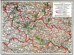
Kharkiv Governorate was a governorate of Ukraine from 1918 to 1925.

<span class="mw-page-title-main">Chernihiv Governorate</span> 1802–1925 unit of Russia and Ukraine

Chernihiv Governorate was an administrative-territorial unit of the Ukrainian State and the Ukrainian SSR, existing from 1918 to 1925. It was inherited from the Russian system of territorial subdivisions that existed prior to World War I. Specifically, Chernigov Governorate, also known as the Government of Chernigov, was an administrative-territorial unit (guberniya) of the Russian Empire. It included the territory of the left-bank Ukraine and was officially created in 1802 from Malorossiya Governorate with its capital in Chernigov (Chernihiv). Little Russian Governorate was transformed into the General Government of Little Russia and consisted of Chernigov Governorate, Poltava Governorate, and later Kharkov Governorate.

<span class="mw-page-title-main">Voronezh Governorate</span> 1725–1928 unit of Russia

Voronezh Governorate was an administrative-territorial unit (guberniya) of the Tsardom of Russia, the Russian Empire, and the Russian SFSR, which existed from 1708 to 1779 and again from 1796 to 1928. Its capital was located in Voronezh since 1725.

<span class="mw-page-title-main">Nizhny Novgorod Governorate</span> 1714–1929 unit of Russia

Nizhny Novgorod Governorate was an administrative-territorial unit (guberniya) of the Russian Empire, Russian Republic, and the Russian SFSR, roughly corresponding to the Upper and Middle Volga region and what is now most of the Nizhny Novgorod Oblast. In the early of 20th Century, Nizhny Novgorod Governorate bordered Kostroma and Vyatka governorates to the north, Vladimir Governorate to the west, Kazan and Simbirsk governorates to the east, and Penza with Tambov governorates to the south.

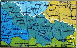
Bogodukhovsky Uyezd was an uyezd (district) in the Kharkov Governorate of the Russian Empire.

Lebedinsky Uyezd was an uyezd (district) in the Kharkov Governorate of the Russian Empire.

Akhtyrsky Uyezd was an uyezd (district) in the Kharkov Governorate of the Russian Empire, Ukrainian State and Soviet Ukraine

Kharkovsky Uyezd was an uyezd (district) in the Kharkov Governorate of the Russian Empire.

Zmiev uyezd was an uezd (district) in the Kharkov Governorate of the Russian Empire.

<span class="mw-page-title-main">Abolition of the Cossack system in Sloboda Ukraine</span>

The abolition of the Cossack system in Sloboda Ukraine was an administrative and military reform of the government of the Russian Empire, carried out in 1763-1765 and aimed at eliminating the autonomy of the Sloboda Cossack regiments. As a result of the reform, Russian state institutions began to operate on the territory of Sloboda Ukraine, and the Cossack regiments were reformed into Hussar regiments. The Kharkov Governorate with its center in Kharkiv was formed on the territory of the Sloboda regiments.

References

  1. 1 2 3 "Slobidska Ukraine gubernia". www.encyclopediaofukraine.com. Retrieved 2023-10-26.
  2. "Vicegerency". www.encyclopediaofukraine.com. Retrieved 2023-10-26.
  3. 1 2 3 "Kharkiv gubernia". www.encyclopediaofukraine.com. Retrieved 2023-10-26.
  4. "Pales of Settlement". Shorter Jewish Encyclopedia. Retrieved 2022-04-13.
  5. История Харьковской епархии (1850-2013) (2-е ed.). Харьков: "Константа", ФЛП Панов. прот. Матвеенко М. 2020. p. 23. ISBN   978-617-77-22-81-5.
  6. Language Statistics of 1897 Archived 2011-06-22 at the Wayback Machine (in Russian)

Further reading

50°00′00″N36°13′45″E / 50.0000°N 36.2292°E / 50.0000; 36.2292