
Semey ), formerly known as Semipalatinsk until 2007 and as Alash-Qala from 1917 to 1920, is a city in eastern Kazakhstan, in the Kazakh part of Siberia. When Abai Region was created in 2022, Semey became its administrative centre. It lies along the Irtysh River near the border with Russia, 1,000 kilometers (620 mi) north of Almaty and 700 kilometers (430 mi) southeast of the Russian city of Omsk. Its population is 350,967.

Kazakhstan is divided into 17 regions. The regions are further subdivided into districts. Three cities, Almaty, Shymkent, and the capital city Astana, do not belong to their surrounding regions.

The Semipalatinsk Test Site or Semipalatinsk-21, also known as "The Polygon", was the primary testing venue for the Soviet Union's nuclear weapons. It is located in Zhanasemey District, Abai Region, Kazakhstan, south of the valley of the Irtysh River. The test site was part of the former Kazakh SSR. The scientific buildings for the test site were located around 150 km (93 mi) west of the town of Semipalatinsk, later renamed Semey, near the border of East Kazakhstan Region and Pavlodar Region. Most of the nuclear tests taking place at various sites further to the west and the south, some as far as into Karagandy Region.

Jetisu or Semirechye is a historical region in Central Asia corresponding to the southeastern part of modern Kazakhstan.

The Turkestan–Siberian Railway is a 1,520 mm broad gauge railway that connects Central Asia with Siberia. It starts north of Tashkent in Uzbekistan at Arys, where it branches off from the Trans-Aral Railway. It heads roughly northeast through Shymkent, Taraz, Bishkek to the former Kazakh capital of Almaty. There it turns northward to Semey before crossing the Russian border. It passes through Barnaul before ending at Novosibirsk, where it meets the West Siberian portion of the Trans-Siberian Railway. The bulk of construction work was undertaken between 1926 and 1931.
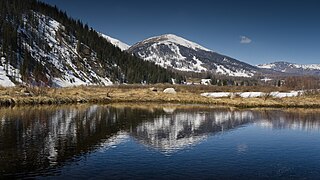
East Kazakhstan Region is a region of Kazakhstan. It occupies the easternmost part of Kazakhstan, and includes parts of the Irtysh River, Lake Markakol, and Lake Zaysan. Its administrative center is Öskemen. The region borders Altai Krai and Altai republic in Russia in the north and northeast and the People's Republic of China, via Xinjiang, in the south and southeast. The easternmost point of the Oblast is within about 50 kilometres of the westernmost tip of Mongolia; however, Kazakhstan and Mongolia do not share a common border, the two countries being separated by a small part of Russia and China.

The Kazakh Autonomous Socialist Soviet Republic, abbreviated as Kazak ASSR and simply Kazakhstan, was an autonomous republic of the Russian Soviet Federative Socialist Republic (RSFSR) within the Soviet Union which existed from 1920 until 1936.

There has been a substantial population of Russian Kazakhstanis, or simply Russian Kazakhs, which are ethnic Russians living in Kazakhstan as their citizen, since the 19th century. Although their numbers have been reduced since the breakup of the Soviet Union, they remain prominent in Kazakh society today. Russians formed a plurality of the Kazakh SSR's population for several decades.

The Emblem of Kazakhstan was adopted on 4 June 1992. The designers of the emblem are Jandarbek Melibekov and Shot-Aman Ualikhan. About 245 projects and 67 description designs of the future arms took part in the final competition. Like other post-Soviet republics whose symbols do not predate the October Revolution, the current emblem retains some components of the Soviet one, in this case, rising sun rays and star. Prior to 1992, Kazakhstan had an emblem similar to all other Soviet Republics.

Shokan Shyngysuly Walikhanov, given name Mukhammed Kanafiya was a Kazakh scholar, ethnographer, historian and participant in the Great Game. His reputation "as the father of modern Kazakh history and ethnography" is recorded in the Historical Dictionary of Kazakhstan. The Kazakh Academy of Sciences became the Ch.Ch. Valikhanov Kazakh Academy of Sciences in 1960. English-language texts sometimes give his name as "Chokan Valikhanov", based on a transliteration of the Russian spelling that he used himself.

Kurchatov is a town in Abai Region in north-east Kazakhstan. Named after Soviet nuclear physicist Igor Kurchatov, the town was once the centre of operations for the adjoining Semipalatinsk Test Site. With the cessation of nuclear testing and the decommissioning of the test site, Kurchatov's population has fallen from over 20,000 to around 8,000. In its heyday, Kurchatov was a closed city, one of the most secretive and restricted places in the Soviet Union. The nuclear facilities at Kurchatov are managed by the Kazakhstan Institute of Atomic Energy, a division of the country's National Nuclear Center.

The Semirechyenskaya Oblast was an oblast (province) of the Russian Empire. It corresponded approximately to most of present-day southeastern Kazakhstan and northeastern Kyrgyzstan. It was created out of the territories of the northern part of the Khanate of Kokand that had been part of the Kazakh Khanate. The name "Semirechye" itself is the direct Russian translation of the historical region of Jetysu. Its site of government was Verniy.

Akmolinsk Oblast was an Oblast (province) of the Russian Empire. It roughly corresponded to most of present-day northern Kazakhstan and the southern part of Omsk Oblast in Russia. It was formerly part of Kazakh khanate. It was created after the division of the Siberian Kirghiz into the oblasts Akmolinsk and Semirechensk on 21 October 1868. Its center was Omsk and consisted of uezds of Akmolinsk, Atbasar, Kokchetav, Omsk and Petropavlovsk. It bordered Tobolsk Governorate to the north, Semipalatinsk Oblast to the east, Semirechye Oblast to the northeast, Syr-Darya Oblast to the south, Turgay Oblast to the southwest and Orenburg Governorate to the northwest.
Charsk or Shar is a town in Zharma District in Abai Region of eastern Kazakhstan.
Semipalatinsk Oblast may refer to:

Semipalatinsk Oblast was an administrative division of the Kazakh Soviet Socialist Republic in the Soviet Union, established on October 14, 1939 from parts of East Kazakhstan and Alma-Ata Oblasts. Upon Kazakhstan's independence in 1991, the oblast continued to exist until 1997, when it was merged back into East Kazakhstan Oblast. In 2022, the region was reconstituted as the Abai Region, with its administrative centre still located in Semey.
The Kazakh Air Defense Forces is the aviation warfare branch of the Armed Forces of the Republic of Kazakhstan. Their responsibilities include protecting Kazakh airspace, as well as combat missions in support of other branches of the armed forces. The official holiday of the air forces is Aviation Day on August 18.
Shakarim Qudaiberdiuly (Kazakh: Шәкәрім Құдайбердіұлы, who was born 23 July [O.S. 11 July] 1858 in Ken-Bulak, Semipalatinsk Oblast and died 2 October 1931 in the Chinghistau tract, Soviet Union, was a Kazakh poet, Hanafi Maturidi theologian philosopher, historian, translator and composer. He is known for being a disciple and nephew of Abai Qunanbaiuly.
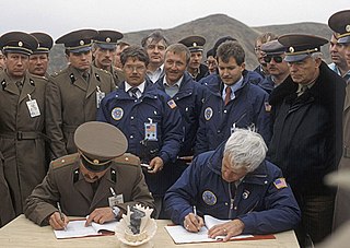
The Republic of Kazakhstan, once a republic of the Soviet Union, was a primary venue for Soviet nuclear weapon testing from 1949 until 1989. Following the collapse of the Union of Soviet Socialist Republics (USSR) in 1991, Kazakhstan became the fourth-largest nuclear power in the world and hosted a considerably large weapon support infrastructure due to its reliance on the Soviet nuclear program as a means to develop its own local economy. Besides the nuclear program, Kazakhstan was also a prominent site of Soviet programs of biological and chemical weapons.

Zhanasemey District is a district of Abai Region in eastern Kazakhstan. The administrative center is Semey city, although it is not part of the district.

