
Lake Ladoga is a freshwater lake located in the Republic of Karelia and Leningrad Oblast in northwestern Russia, in the vicinity of Saint Petersburg.

The Republic of Karelia, Karjala or Karelia is a republic of Russia situated in the northwest of the country. The republic is a part of the Northwestern Federal District, and covers an area of 172,400 square kilometres, with a population of 533,121 residents. Its capital is Petrozavodsk.
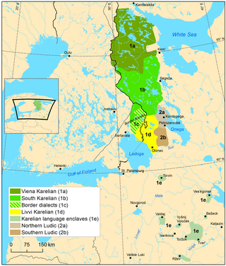
Karelian is a Finnic language spoken mainly in the Russian Republic of Karelia. Linguistically, Karelian is closely related to the Finnish dialects spoken in eastern Finland, and some Finnish linguists have even classified Karelian as a dialect of Finnish, but nowadays it is widely considered a separate language. Karelian is not to be confused with the Southeastern dialects of Finnish, sometimes referred to as karjalaismurteet in Finland. In the Russian 2020–2021 census, around 9,000 people spoke Karelian natively, but around 14,000 said they were able to speak the language. There are around 11,000 speakers of Karelian in Finland. And around 30,000 people in Finland have at least some knowledge of Karelian.

Petrozavodsk is the capital city of the Republic of Karelia, Russia, which stretches along the western shore of Lake Onega for some 27 kilometers (17 mi). The population of the city is 280,890 as of 2022.

Lake Onega is a lake in northwestern Russia, on the territory of the Republic of Karelia, Leningrad Oblast and Vologda Oblast. It belongs to the basin of the Baltic Sea, and is the second-largest lake in Europe after Lake Ladoga, slightly smaller than Lebanon. The lake is fed by about 50 rivers and is drained by the Svir.

Leningrad Oblast is a federal subject of Russia. The oblast has an area of 84,500 square kilometres (32,600 sq mi) and a population of 2,000,997 ; up from 1,716,868 recorded in the 2010 Census. Leningrad Oblast is highly industrialized. Its administrative center and largest city is Gatchina.

The Svir is a river in Podporozhsky, Lodeynopolsky, and Volkhovsky districts in the north-east of Leningrad Oblast, Russia. It flows westwards from Lake Onega to Lake Ladoga, thus connecting the two largest lakes of Europe. It is the largest river flowing into Lake Ladoga. The length of the Svir is 224 kilometres (139 mi), whereas the area of its drainage basin is 84,400 square kilometres (32,600 sq mi). The towns of Podporozhye and Lodeynoye Pole, as well as urban-type settlements Voznesenye, Nikolsky, Vazhiny, and Svirstroy are located at the banks of the Svir.

Karelia is an area in Northern Europe of historical significance for Russia, Finland, and Sweden. It is currently divided between northwestern Russia and Finland.

Olonets Karelia is a historical and cultural region and the southern portion of East Karelia, which is part of Russia. Olonets Karelia is located between the other historical regions of Ladoga Karelia, to its west, White Karelia, to its north, the River Svir, to its south and Lake Onega on its eastern side. Olonets Karelia is home to its own dialect of the Karelian language, which is known as Livvi Karelian or sometimes as 'Olonets Karelian'.

Ladoga Karelia is a historical region of Karelia, currently largely in Russia. Today, the term refers to the part of the Republic of Karelia in the Russian Federation comprising the south-west part of the Republic, specifically Lakhdenpokhsky District, Pitkyarantsky District and Sortavala District. This region is on the northern littoral of Lake Ladoga, which borders Olonets Karelia to the East, Leningrad Oblast to the south-west and the North Karelia region of Finland to the west.
Vytegra is a town and the administrative center of Vytegorsky District in Vologda Oblast, Russia, located along the shores of the Vytegra River on Volga–Baltic Waterway, 315 kilometers (196 mi) northwest of Vologda, the administrative center of the oblast. Population: 10,488 (2010 Census); 11,400 (2002 Census); 12,905 (1989 Soviet census).

The Finnish invasion of East Karelia was a military campaign in 1941. It was part of the Continuation War. Finnish troops occupied East Karelia and held it until 1944. For over a month after the outbreak of the Continuation War, the Karelian Army reinforced and prepared to resume its earlier offensive while waiting for the recapture of the Karelian Isthmus. The Soviets had prepared fortifications and brought troops to the front. When encirclements on the western shore of Lake Ladoga were resolved, the Finnish 7th Division was transferred to the junction of VI and VII Corps.

The administrative division of Novgorod Republic is not definitely known; the country was divided into several tysyachas and volosts. The city of Novgorod with its vicinity, as well as a few other towns, were not part of any of those. Pskov achieved an autonomy from Novgorod in the 13th century; its independence was confirmed by the Treaty of Bolotovo in 1348.

Novgorod Governorate was an administrative-territorial unit (guberniya) of the Russian Empire and the Russian SFSR, which existed from 1727 to 1776 and from 1796 to 1927. Its administrative center was in the city of Novgorod. The governorate was located in the northwest of the European part of the Russian Empire.
Northwest Russia, or the Russian North is the northern part of western Russia. It is bounded by Norway, Finland, the Arctic Ocean, the Ural Mountains and the east-flowing part of the Volga. The area is roughly coterminous with the Northwestern Federal District, which it is administered as part of. Historically, it was the area of the Novgorod and Pskov merchant republics.

Lodeynopolsky District is an administrative and municipal district (raion), one of the seventeen in Leningrad Oblast, Russia. It is located in the northeast of the oblast and borders with Olonetsky District of the Republic of Karelia in the north, Podporozhsky District in the east, Tikhvinsky District in the south, and Volkhovsky District in the west. The area of the district is 4,900 square kilometers (1,900 sq mi). Its administrative center is the town of Lodeynoye Pole. Population : 9,795 (2010 Census); 12,185 ; 13,426 (1989 Soviet census).

Podporozhsky District is an administrative and municipal district (raion), one of the seventeen in Leningrad Oblast, Russia. It is located in the northeast of the oblast and borders with Prionezhsky District of the Republic of Karelia in the north, Vytegorsky District of Vologda Oblast in the east, Babayevsky District of Vologda Oblast in the southeast, Tikhvinsky District in the south, Lodeynopolsky District in the southwest, and Olonetsky and Pryazhinsky Districts of the Republic of Karelia in the northwest. In the northeast, the district is bounded by Lake Onega. The area of the district is 7,679 square kilometers (2,965 sq mi), which makes it the largest district in Leningrad Oblast. Its administrative center is the town of Podporozhye. Population : 13,000 (2010 Census); 14,845 ; 18,075 (1989 Soviet census).
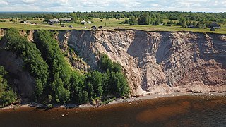
Vytegorsky District is an administrative and municipal district (raion), one of the twenty-six in Vologda Oblast, Russia. It is located in the northwest of the oblast and borders with Pudozhsky District of the Republic of Karelia in the north, Kargopolsky District of Arkhangelsk Oblast in the east, Kirillovsky, Vashkinsky, and Belozersky Districts in the southeast, Vologodsky District in the southeast, Babayevsky District in the southwest, and with Podporozhsky District of Leningrad Oblast in the west. The area of the district is 13,100 square kilometers (5,100 sq mi), making it the largest district in Vologda Oblast. Its administrative center is the town of Vytegra. Population: 27,139 (2010 Census); 31,757 ; 37,792 (1989 Soviet census). The population of Vytegra accounts for 38.6% of the district's total population.
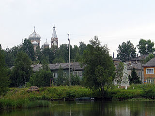
Olonets is a town in the Republic of Karelia, Russia
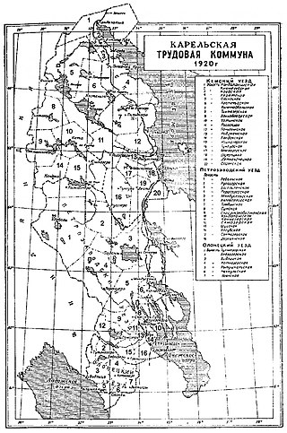
The Karelian Labor Commune was an autonomous region established in 1920 following the successes of the Red Army's incursion into the Republic of Uhtua, to undermine and discredit the separatist movements and to make Finland give up on attempting to liberate East Karelia shortly before the beginning of negotiations for the Treaty of Tartu and during the Heimosodat. Edvard Gylling and Yrjö Sirola, former members of the government of the Finnish Socialist Workers' Republic, met with Vladimir Lenin in the Kremlin to propose autonomy for Karelia within the Russian Soviet Federative Socialist Republic. The Commune was founded on 8 June 1920 and was disestablished on 25 July 1923 and succeeded by the Karelian ASSR, following the end of the Heimosodat.

