Minsk Governorate

Last updated
Minsk Governorate
Минская губерния
Governorate of the Russian Empire
1793–1921
Coat of arms of Minsk Governorate 1878.svg
Coat of arms
Minsk in Russian Empire (1914).svg
Location in the Russian Empire
Capital Minsk
Area 
 
91,213 km2 (35,218 sq mi)
Population 
 
2,539,100
History 
 Established
23 March 1793
 Disestablished
1921
Preceded by
Succeeded by
Herbarz Kaspra Niesieckiego Minskoe.svg Minsk Voivodeship
Minsk Okrug Blank.png
Slutsk Okrug Blank.png
Bobruysk Okrug Blank.png
Polissia Okruha Blank.png
Borisov Okrug Blank.png
Gomel Governorate Blank.png
Polesie Voivodeship Blank.png
Today part of Belarus

Minsk Governorate [lower-alpha 1] was an administrative-territorial unit ( guberniya ) of the Russian Empire, with its capital in Minsk. It was created from the land acquired in the partitions of Poland and existed from 1793 until 1921. Its territory covered the majority of modern-day Belarus.

Contents

Administrative divisions

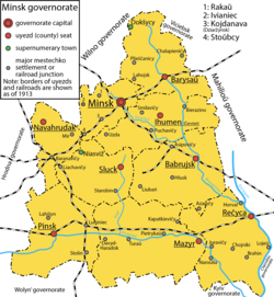
Uyezds of Minsk Governorate in 1913 1913 - Minsk governorate.png
Uyezds of Minsk Governorate in 1913

Vileysky and Disnensky Uyezds passed to the Vilna Governorate in 1843. In 1919, Baranovichsky Uyezd was created from Novogorodoksky Uyezd and Nesvizhsky Uyezd was created from Slutsky Uyezd. In 1920, Novogrudoksky, Pinsky, Baranovichsky, and Nesvizhsky Uyezds were controlled by Poland.

Demographics

According to the 1897 imperial census, Minsk Governorate had a population of 2,147,621. The ethnic makeup (based on native language) was as follows: [1]

County Belarusians Jews Russians Poles Ukrainians
(total)76,0 %16,0 %3,9 %3,0 %
Bobruysky Uyezd 67,4 %19,4 %10,0 %2,0 %
Borisovsky Uyezd 80,9 %11,2 %3,1 %4,1 %
Igumensky Uyezd 82,6 %12,3 %1,8 %2,9 %
Minsky Uyezd 59,2 %23,1 %9,5 %7,1 %
Mozyrsky Uyezd 79,5 %16,3 %1,5 %2,1 %
Novogrudsky Uyezd 83,7 %12,3 %1,6 %1,7 %
Pinsky Uyezd 74,3 %19,5 %2,6 %2,6 %
Rechitsky Uyezd 82,5 %12,8 %1,4 %1,1 %1,7 %
Slutsky Uyezd 78,5 %15,7 %1,8 %2,8 %

Industry

Minsk province has mostly swampy terrain and clay soil, but the climate is favorable for agriculture. [2] Flax and hemp were planted for home use.

Horticulture is common everywhere, primarily in the form of subsistence farming. In the city of Minsk, horticulture is mainly done by Tatars, in Bobruysk by Old Believers. Horticulture spread everywhere, but it was not lacking in industrial character, it is a special property of every household, starting with a peasant and ending with a rich landowner. One feature of horticulture in the Minsk provinces was that each gardener tried to grow as many different fruit trees as possible. Since horticulture was not of an industrial nature, fruits were imported from Little Russia.

Beekeeping was spread throughout the province, although it was not of an industrial nature. In 1897, there were 11,740 beekeepers.

Forestry, which was exclusively practiced by Jews, played a significant role.

Cattle breeding and sheep breeding was widespread throughout the province.

Factory and similar industry is limited only to the needs of its own province. In 1860, there were 594 factories and plants; in 1879 — 623; [3] in 1895 — 378; [4] in 1912 — 493.

In 1912, there were 61,485 artisans, 20,842 of them in cities.

Governors

NAME.Title, rank, rank.Time of holding office
1808—21.05.1812
21.05.1812—1815
1818-1831
16.03.1831—26.04.1831
26.04.1831—12.01.1835
12.01.1835—1838
16.12.1838—1841
1841—19.11.1842
19.11.1842—02.05.1844
02.05.1844—26.01.1850
27.01.1850—21.04.1850
21.04.1850—18.10.1857
18.10.1857—03.02.1858
08.02.1858—27.05.1861
14.11.1861—13.06.1862
15.06.1862—03.04.1864
24.05.1864—19.05.1868
19.05.1868—21.08.1869
privy councilor02.11.1869—24.10.1875
05.12.1875—30.08.1879
30.08.1879—30.01.1886
11.02.1886—20.07.1902
13.08.1902—16.05.1905
16.05.1905—15.07.1906
15.07.1906—26.11.1912
26.11.1912—1915
30.10.1915—15.08.1916
08.1916—1917

Related Research Articles

<span class="mw-page-title-main">Saint Petersburg Governorate</span> 1708–1927 unit of Russia

The Saint Petersburg Governorate was a province (guberniya) of the Russian Empire, with its capital in Saint Petersburg. The governorate was composed of 44,613 square kilometres (17,225 sq mi) of area and 2,112,033 inhabitants. It was bordered by Estonian and Livonian Governorates to the west, Pskov Governorate to the south, Novgorod Governorate to the east, Olonets Governorate to the northeast, and Vyborg Governorate of the Grand Duchy of Finland to the north. The governorate covered most of the areas of modern Leningrad Oblast and Ida-Viru, Jõgeva, Tartu, Põlva, and Võru counties of Estonia.

<span class="mw-page-title-main">Mga</span> Urban-type settlement in Leningrad Oblast, Russia

Mga is an urban locality in Kirovsky District of Leningrad Oblast, Russia. Population: 10,212 (2010 Census); 9,613 (2002 Census); 9,852 (1989 Soviet census).

<span class="mw-page-title-main">Yekaterinoslav Governorate</span> 1802–1925 unit of Russia

Yekaterinoslav Governorate was an administrative-territorial unit (guberniya) of the Russian Empire, with its capital in Yekaterinoslav. It bordered Poltava Governorate to the north, Don Host Oblast to the east, Sea of Azov to the southeast, Taurida Governorate to the south, and Kherson Governorate to the east, and covered the area of the Luhansk, Donetsk, Dnipropetrovsk, and Zaporizhzhia Oblasts of modern Ukraine.

Krasny Kholm is a town and the administrative center of Krasnokholmsky District in Tver Oblast, Russia. Population: 5,608 (2010 Census); 6,396 (2002 Census); 7,875 (1989 Soviet census).

Within the framework of administrative divisions, Arkhangelsk Oblast is divided into six cities and towns of oblast significance, twenty-one districts, and two island territories. Besides, Mirny is a town under the federal government management.

<span class="mw-page-title-main">Siversky</span> Urban-type settlement in Leningrad Oblast, Russia

Siversky is an urban locality in Gatchinsky District of Leningrad Oblast, Russia, on the bank of the Oredezh River. Its population was 12,216 (2010 Census); 12,137 (2002 Census); 11,885 (1989 Soviet census).

<span class="mw-page-title-main">Vsevolozhsky District</span> District in Leningrad Oblast, Russia

Vsevolozhsky District is an administrative and municipal district (raion), one of the seventeen in Leningrad Oblast, Russia. It is located in the central northwestern part of the oblast on the Karelian Isthmus and borders with Priozersky District in the north, Kirovsky District in the south, Vyborgsky District in the northwest, Nevsky, Krasnogvardeysky, Kalininsky, Vyborgsky, and Kurortny Districts of the federal city of St. Petersburg in the west, and is washed by Lake Ladoga in the east. The area of the district is 3,036.4 square kilometers (1,172.4 sq mi). Its administrative center is the town of Vsevolozhsk. Population : 153,045 (2010 Census); 131,233 ; 135,318 (1989 Soviet census).

<span class="mw-page-title-main">Vilna Governorate</span> 1795–1918 unit of Russia

The Vilna Governorate was a province (guberniya) of the Northwestern Krai of the Russian Empire. In 1897, the governorate covered an area of 41,907.9 square kilometres (16,180.7 sq mi) and had a population of 1,591,207 inhabitants. The governorate was defined by the Minsk Governorate to the south, the Grodno Governorate to the southwest, the Suwałki Governorate to the west, the Kovno and Courland Governorates to the north, and the Vitebsk Governorate to the east. The capital was located in Vilna (Vilnius). The city also served as the capital of Vilna Governorate-General, which existed until 1912. The area roughly corresponded to the Vilnius Region, which was later occupied by Germany, Bolsheviks, and Poland.

<span class="mw-page-title-main">Shemakha Governorate</span> 1846–1859 unit of Russia

Shemakha Governorate was an administrative-territorial unit (guberniya) of the Caucasus Viceroyalty of the Russian Empire, with its administrative center in Shemakha (Shamakhi). Following the earthquake of 1859, the capital was transferred and the province became known as the Baku Governorate.

<span class="mw-page-title-main">Vyatka Governorate</span> 1796–1929 unit of Russia

Vyatka Governorate was an administrative-territorial unit (guberniya) of the Russian Empire and the Russian SFSR from 1796 to 1929, with its capital in Vyatka. The area of the governorate roughly corresponds to modern-day Kirov Oblast and Udmurtia.

<span class="mw-page-title-main">Kaduy, Vologda Oblast</span> Urban-type settlement in Vologda Oblast, Russia

Kaduy is an urban locality and the administrative center of Kaduysky District of Vologda Oblast, Russia, located on the Voron River at the confluence with the Sivets River, 56 kilometers (35 mi) west of the city of Cherepovets. Municipally, it is incorporated as Kaduyskoye Urban Settlement, one of the two urban settlements in the district. Population: 11,284 (2010 Census); 11,798 (2002 Census); 11,153 (1989 Soviet census).

<span class="mw-page-title-main">Vladimir Governorate</span> 1796–1929 unit of Russia

Vladimir Governorate was an administrative-territorial unit (guberniya) of the Russian Empire, the Russian Republic and the Russian SFSR, which existed in 1796–1929.

<span class="mw-page-title-main">Vitebsk Governorate</span> 1802–1924 unit of Russia

Vitebsk Governorate was an administrative-territorial unit (guberniya) of the Russian Empire, with the seat of governorship in Vitebsk. It was established in 1802 by splitting Belarusian Governorate and existed until 1924. Today most of the area belongs to Belarus, the northwestern part to Latvia and the northeastern part to Pskov and Smolensk Oblasts of Russia.Together with the Vilna, Kovno, Grodno, Minsk, and Mogilev Governorates, it formed the Northwestern Krai. The provincial city was Vitebsk, the largest city was Dvinsk.

Caucasus Governorate was an administrative division (guberniya) of the Russian Empire, which existed from 1802 until 1822. Its seat was located in Georgiyevsk. The governorate was located in the south of the European part of the Russian Empire. In 1822, the governorate was abolished and transformed into Caucasus Oblast, with the administrative center in Stavropol. In terms of modern administrative divisions of Russia, the area of Caucasus Governorate is currently split between Stavropol and Krasnodar Krais, Rostov Oblast, and the Republics of Kabardino-Balkaria, North Ossetia–Alania, Ingushetia, Chechnya, Dagestan, and Kalmykia, with the major part of it being located in Stavropol Krai.

<span class="mw-page-title-main">Kiev Governorate (1708–1764)</span> 1708–1764 unit of Russia

Kiev Governorate was an administrative-territorial unit (guberniya) of the Tsardom of Russia and the Russian Empire. It was established in December 1708 as one of the eight guberniyas first created during the reforms of Peter the Great.

<span class="mw-page-title-main">Imeni Sverdlova, Russia</span> Urban-type settlement in Leningrad Oblast, Russia

Imeni Sverdlova is an urban locality in Vsevolozhsky District of Leningrad Oblast, Russia, located on the right bank of the Neva River, southeast of the center of Saint Petersburg and opposite to Ust-Izhora. Municipally it is incorporated as Sverdlovskoye Urban Settlement, one of the eight urban settlements in the district. Population: 9,260 (2010 Census); 9,197 (2002 Census); 8,905 (1989 Soviet census).

<span class="mw-page-title-main">Tver Governorate</span> 1796–1929 unit of Russia

Tver Governorate was an administrative-territorial unit (guberniya) of the Russian Empire and the Russian SFSR, which existed from 1796 until 1929. Its seat was in Tver. The governorate was located in the north of the European part of the Russian Empire and bordered Novgorod Governorate in the north, Yaroslavl Governorate in the east, Vladimir Governorate in the southeast, Moscow Governorate in the south, Smolensk Governorate in the southwest, and Pskov Governorate in the west.

<span class="mw-page-title-main">Simbirsk Governorate</span> 1796–1928 unit of Russia

Simbirsk Governorate was an administrative-territorial unit (guberniya) of the Russian Empire and the Russian SFSR, which existed from 1796 to 1928. Its administrative center was in the city of Simbirsk, renamed Ulyanovsk in 1924.

<span class="mw-page-title-main">Tomsk Governorate</span> 1804–1925 unit of Russia

Tomsk Governorate was an administrative-territorial unit (guberniya) of the Russian Empire, the Russian Republic, and the Russian SFSR, which existed from 1804 to 1925 as part of Siberian Governorate-General (1804–1822) and West Siberian Governorate-General (1822–1882). Its capital was in Tomsk.

<span class="mw-page-title-main">Kolyvan Viceroyalty</span> 1783–1796 unit of Russia

Kolyvan Viceroyalty, later Kolyvan Governorate, was an administrative-territorial unit of the Russian Empire, which existed in 1783–1796.

References

  1. "Первая всеобщая перепись населения Российской Империи 1897 г. Распределение населения по родному языку и уездам 50 губерний Европейской России". demoscope.ru. Демоскоп Weekly. Archived from the original on 4 February 2023. Retrieved 15 March 2024.
  2. Панченко, Алексей Борисович (2018). "Д.А. КЛЕМЕНЦ И ПРОИЗВОДСТВО ЗНАНИЯ О НАРОДАХ В РОССИЙСКОЙ ИМПЕРИИ, "Этнографическое обозрение"". Этнографическое обозрение (2): 122–136. doi:10.7868/s0869541518020094. ISSN   0869-5415.
  3. Панченко, Алексей Борисович (2018). "Д.А. КЛЕМЕНЦ И ПРОИЗВОДСТВО ЗНАНИЯ О НАРОДАХ В РОССИЙСКОЙ ИМПЕРИИ, "Этнографическое обозрение"". Этнографическое обозрение (2): 122–136. doi:10.7868/s0869541518020094. ISSN   0869-5415.
  4. Панченко, Алексей Борисович (2018). "Д.А. КЛЕМЕНЦ И ПРОИЗВОДСТВО ЗНАНИЯ О НАРОДАХ В РОССИЙСКОЙ ИМПЕРИИ, "Этнографическое обозрение"". Этнографическое обозрение (2): 122–136. doi:10.7868/s0869541518020094. ISSN   0869-5415.

Further reading

53°54′08″N27°33′42″E / 53.9022°N 27.5618°E / 53.9022; 27.5618