A Historical Atlas of South Asia is a historical chronology of the region of South Asia from prehistoric times through the present. It was edited and largely authored by Joseph E. Schwartzberg, professor emeritus of South Asian Studies at the University of Minnesota. It is highly regarded by scholars of South Asian history for its vast amount of detail and coverage of the region's lengthy and complex history. The atlas is divided into two main sections: maps and photographs, and prose which corresponds to and explains the maps.
The initial assembly of the Atlas began in 1964 with many authors, historians, cartographers and researchers contributing over a fourteen-year period. Although many consider the atlas to be the ultimate resource for students and scholars alike, the authors stress that "it is intended to supplement existing histories of South Asia...not to be used in place of them."
The atlas was first published in 1978 by the University of Chicago Press. About 3,300 total copies were produced and all of them sold, which caused the atlas to become out of print. In 1992, Schwartzberg and a new team of historians released a slightly updated second edition titled Second Impression, with Additional Material and published by Oxford University Press. This edition is now also out of print.
In 1980 the American Historical Association bestowed the Watumull Prize on the Atlas.
Amerigo Vespucci was an Italian explorer and navigator from the Republic of Florence for whom "America" is named.

Martin Waldseemüller was a German cartographer and humanist scholar. Sometimes known by the Latinized form of his name, Hylacomylus, his work was influential among contemporary cartographers. His collaborator Matthias Ringmann and he are credited with the first recorded usage of the word America to name a portion of the New World in honour of Italian explorer Amerigo Vespucci in a world map they delineated in 1507. Waldseemüller was also the first to map South America as a continent separate from Asia, the first to produce a printed globe, and the first to create a printed wall map of Europe. A set of his maps printed as an appendix to the 1513 edition of Ptolemy's Geography is considered to be the first example of a modern atlas.

John Speed was an English cartographer, chronologer and historian of Cheshire origins. The son of a citizen and Merchant Taylor in London, he rose from his family occupation to accept the task of drawing together and revising the histories, topographies and maps of the Kingdoms of Great Britain as an exposition of the union of their monarchies in the person of King James I and VI. He accomplished this with remarkable success, with the support and assistance of the leading antiquarian scholars of his generation. He drew upon and improved the shire maps of Christopher Saxton, John Norden and others, being the first to incorporate the hundred-boundaries into them, and he was the surveyor and originator of many of the town or city plans inset within them. His work helped to define early modern concepts of British national identity. His Biblical genealogies were also formally associated with the first edition of the King James Bible. He is among the most famous of English mapmakers.

A gazetteer is a geographical dictionary or directory used in conjunction with a map or atlas. It typically contains information concerning the geographical makeup, social statistics and physical features of a country, region, or continent. Content of a gazetteer can include a subject's location, dimensions of peaks and waterways, population, gross domestic product and literacy rate. This information is generally divided into topics with entries listed in alphabetical order.

John King Fairbank was an American historian of China and United States–China relations. He taught at Harvard University from 1936 until his retirement in 1977. He is credited with building the field of China studies in the United States after World War II with his organizational ability, his mentorship of students, support of fellow scholars, and formulation of basic concepts to be tested.
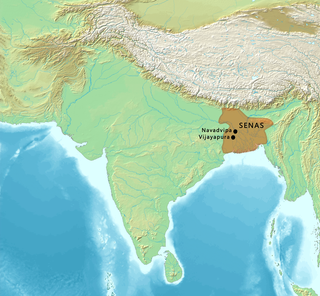
The Sena dynasty was a Hindu dynasty during the early medieval period on the Indian subcontinent, that ruled from Bengal through the 11th and 12th centuries. The empire at its peak covered much of the north-eastern region of the Indian subcontinent. The rulers of the Sena Dynasty traced their origin to the south Indian region of Karnataka.

Medieval India refers to a long period of post-classical history of the Indian subcontinent between the "ancient period" and "modern period". It is usually regarded as running approximately from the break-up of the Gupta Empire in the 6th century CE to the start of the early modern period in 1526 with the start of the Mughal Empire, although some historians regard it as both starting and finishing later than these points. The medieval period is itself subdivided into the early medieval and late medieval eras.
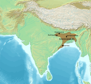
Shashanka was the first independent king of a unified polity in the Bengal region, called the Gauda Kingdom. He reigned in the 7th century, some historians place his rule between c. 600 and 636/7 CE, whereas other sources place his reign between 590 and 625 CE.
The earliest known world maps date to classical antiquity, the oldest examples of the 6th to 5th centuries BCE still based on the flat Earth paradigm. World maps assuming a spherical Earth first appear in the Hellenistic period. The developments of Greek geography during this time, notably by Eratosthenes and Posidonius culminated in the Roman era, with Ptolemy's world map, which would remain authoritative throughout the Middle Ages. Since Ptolemy, knowledge of the approximate size of the Earth allowed cartographers to estimate the extent of their geographical knowledge, and to indicate parts of the planet known to exist but not yet explored as terra incognita.
Joseph E. Schwartzberg was an American writer, peace activist, and a world federalist, who was a tenured professor at the University of Minnesota. Author of numerous books, he was the editor and principal author of the Historical Atlas of South Asia, which in 1980 won the Watumull Prize of the American Historical Association. In 1984 the American Association of Geographers honored him with their annual award. His several substantial chapters in Book One of Volume Two of The History of Cartography were instrumental in that work receiving the R. R. Hawkins Award for Best Scholarly Book for 1992 from the Association of American Publishers. He served on the board of directors of the World Federalist Association, has chaired its Policy and Issues Commission, and is President of the Minnesota chapter of Citizens for Global Solutions.

The Kalabhra dynasty, also called Kaḷabrar, Kaḷappirar, Kallupura or Kalvar, were rulers of all or parts of Tamil region sometime between the 3rd century and 6th century CE, after the ancient dynasties of the early Cholas, the early Pandyas and Chera. Information about the origin and reign of the Kalabhras is uncertain and scarce. It is believed by historians that the Kalabhras belonged to the Vellalar community of warriors who were possibly once the feudatories of the Cholas and the Pallavas. Their proposed roots vary from southeast region of modern Karnataka, Kalappalars of Vellalar community, to Kalavar chieftains. This age is generally called "The Augustan age of Tamil Literature", in a 1922 book by the name "Studies in South Indian Jainism" written by M. S. Ramaswami Ayyangar and B. Seshagiri Rao. The Kalabhra era is sometimes referred to as the "dark period" of Tamil history, and information about it is generally inferred from any mentions in the literature and inscriptions that are dated many centuries after their era ended.

The history of cartography refers to the development and consequences of cartography, or mapmaking technology, throughout human history. Maps have been one of the most important human inventions for millennia, allowing humans to explain and navigate their way through the world.

A historical atlas is a collection of maps and possibly illustrations that depict the historical geography of a particular region at a defined time period. These atlases typically include maps that show the political and cultural boundaries of different states as well as other data, and in some cases illustrations that provide information about important historical events and figures. They may also include timelines, charts, and other information to help readers understand the historical context of the maps. Historical atlases are used by scholars, students, and general readers to study and learn about the past.
The Malavas or Malwas were an ancient Indian tribe. They are believed to be the Mallian people (Malloi) who were settled in the Punjab region at the time of Alexander's invasion in the 4th century BCE. Later, the Malavas migrated southwards to present-day Rajasthan, and ultimately to Madhya Pradesh and Gujarat. Their power gradually declined as a result of defeats against the Western Satraps, the Gupta emperor Samudragupta, and the Chalukya emperor Pulakeshin II.
Aparanta, or Aparantaka was a geographical region of ancient India. It corresponded to the northern part of the Konkan region on the western coast of India. English civil servant-turned-historian J. F. Fleet believed that the Aparanta region included Kathiawad, Kutch, and Sindh, beside Konkan. However, historical records make it clear that the extent of Aparanta was much smaller.
The cartography of India begins with early charts for navigation and constructional plans for buildings. Indian traditions influenced Tibetan and Islamic traditions, and in turn, were influenced by the British cartographers who solidified modern concepts into India's map making.
Burton Stein was an American historian, whose area of specialization was India.

The Mahameghavahana dynasty was an ancient ruling dynasty of Kalinga after the decline of the Maurya Empire. In the first century B.C., Mahameghavahana, a king of Chedirastra conquered Kalinga and Kosala. During the reign of Kharavela, the third king of Mahameghavahana dynasty, South Kosala became an integral part of the kingdom. He patronised Jainism, but did not discriminate against other religions. He is known by his Hathigumpha inscription.
The Gauḍa kingdom was a kingdom during the Classical era in the Indian subcontinent, which originated in the Gauda region of Bengal in 4th century CE or possibly earlier.

The Chahamanas of Shakambhari, colloquially known as the Chauhans of Sambhar or Chauhans of Ajmer, were an Indian dynasty that ruled parts of present-day Rajasthan and neighbouring areas between the sixth and twelfth centuries in the Indian Subcontinent. The territory ruled by them was known as Sapadalaksha. They were the most prominent ruling family of the Chauhan Rajput clan.
