
The Great Game was a rivalry between the 19th-century British and Russian empires over influence in Central Asia, primarily in Afghanistan, Persia, and Tibet. The two colonial empires used military interventions and diplomatic negotiations to acquire and redefine territories in Central and South Asia. Russia conquered Turkestan, and Britain expanded and set the borders of British colonial India. By the early 20th century, a line of independent states, tribes, and monarchies from the shore of the Caspian Sea to the Eastern Himalayas were made into protectorates and territories of the two empires.
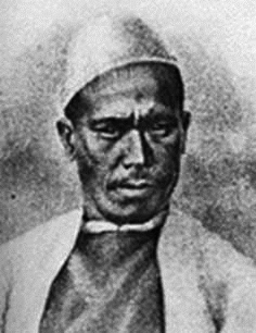
Nain Singh, also known as Nain Singh Rawat, was one of the first Indian explorers employed by the British to explore the Himalayas and Central Asia. He came from the Johar Valley in Kumaon. He surveyed the trade route through Ladakh to Tibet, determined the location and altitude of Lhasa in Tibet, and surveyed a large section of Brahmaputra. He walked "1,580 miles, or 3,160,000 paces, each counted."
Rai Bahadur Kishen Singh or Krishna was a native Indian explorer, termed a pundit by the British, who was employed by the Survey of India.

Major General Sir Alexander Cunningham was a British Army engineer with the Bengal Sappers who later took an interest in the history and archaeology of India. In 1861, he was appointed to the newly created position of archaeological surveyor to the government of India; and he founded and organised what later became the Archaeological Survey of India.
Indianisation of British colonial bureaucracy was a process introduced in the later period of British India whereby Indian officers were promoted to more senior positions in government services, formerly reserved for the British. In the Indian police, the rank of Deputy Superintendent was introduced to prepare Indian officers for promotion to higher rank. In the armed forces, the process referred to the replacement of British officers by Indians. The progress was slow and unsatisfactory to the Indian nationalist politicians, however events, mainly the Second World War and the partition and independence which followed it, overtook the programme.
The Geological Survey of India (GSI) is a scientific agency of India. It was founded in 1851, as a Government of India organization under the Ministry of Mines, one of the oldest of such organisations in the world and the second oldest survey in India after the Survey of India, for conducting geological surveys and studies of India, and also as the prime provider of basic earth science information to government, industry and general public, as well as the official participant in steel, coal, metals, cement, power industries and international geoscientific forums.

The Great Trigonometrical Survey of India was a project that aimed to carry out a survey across the Indian subcontinent with scientific precision. It was begun in 1802 by the British infantry officer William Lambton, under the auspices of the East India Company. Under the leadership of his successor, George Everest, the project was made the responsibility of the Survey of India. Everest was succeeded by Andrew Scott Waugh, and after 1861, the project was led by James Walker, who oversaw its completion in 1871.

Frederick Marshman Bailey was a British political officer and one of the last protagonists of The Great Game. His expeditions in Tibet and Assam Himalaya gave him many opportunities to pursue his hobbies of photography, butterfly collecting and trophy hunting in the high Tibetan region. Over 2000 of his bird specimens were presented to the Natural History Museum, although his personal collection is now held in the American Museum of Natural History, New York. His papers and extensive photograph collections are held in the British Library, London.

Lieutenant-Colonel Thomas George Montgomerie FRS (1830–1878) was a British surveyor who participated in the Great Trigonometric Survey of British India as a lieutenant in the 1850s. He was the person to label K2, the second highest mountain in the world, the K standing for Karakoram.
Milam is the last village situated in Johar valley of Pithoragarh district in the state of Uttarakhand, India. The river Gori Ganga originates from Milam Glacier and flows past the village to meet with Kali ganga at Jauljibi.

The location of Tibet, deep in the Himalaya mountains, made travel to Tibet extraordinarily difficult at any time, in addition to the fact that it traditionally was forbidden to all western foreigners. The internal and external politics of Tibet, China, Bhutan, Assam, and the northern Indian kingdoms combined rendered entry into Tibet politically difficult for all Europeans. The combination of inaccessibility and political sensitivity made Tibet a mystery and a challenge for Europeans well into the 20th century.
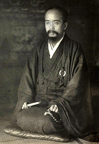
Ekai Kawaguchi was a Japanese Buddhist monk who was famed for his four journeys to Nepal and two to Tibet. He was the first recorded Japanese citizen to travel to either country.
The cartography of India begins with early charts for navigation and constructional plans for buildings. Indian traditions influenced Tibetan and Islamic traditions, and in turn, were influenced by the British cartographers who solidified modern concepts into India's map making.
Man Singh Rawat, commonly known as Mani Compassi, was one of the famous Indian explorers, who played a significant role in the exploration of Central Asia during the "Great Game" between the British and Russians in the second half of the 19th century. Mani Singh was the older brother of Krishna Singh Rawat and older cousin of Nain Singh Rawat, both famous explorers and cartographers, who worked in the Great Trigonometrical Survey of India. Man Singh was born to a trader named Deb Singh Rawat, in Milam village on India-China border now in present day Pithoragarh district.
Political warfare in British colonial India aided a British minority in maintaining control over large parts of present-day India, Bangladesh, Pakistan and Burma.
William H. Johnson was a British surveyor in the Great Trigonometric Survey of India. He is noted for the first definition of the eastern boundary of Ladakh along Aksai Chin in the princely state of Jammu and Kashmir, which has come to be called the 'Johnson Line'. After retiring from the Survey of India, Johnson was appointed as the Governor of Ladakh, in which position he served until his death.
The Bailey–Morshead exploration of the Tsangpo Gorge was an unauthorised expedition by Frederick Bailey and Henry Morshead in 1913 which for the first time established the definite route by which the Tsangpo River reaches the sea from north of Himalaya, through the Tsangpo Gorge.
Thok Jalung was a goldfield in Tibet that gained international attention upon its discovery by the west.
Arthur Douglas Carey was a British civil servant in India, now remembered as a traveller in Central Asia, and in particular for exploration in what is now Xinjiang.
Henry John Harman was a Royal Engineers officer who was involved in surveys in the Himalayas of northeastern India as part of the Great Trigonometrical Survey. He was involved in recruiting and organizing "pandit" explorers to trace out the upper Brahmaputra river and to discover if it was the same as the Tsang-Po. A pheasant species Crossoptilon harmani was named after him and was for sometime called as Harman's pheasant.

