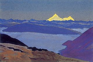
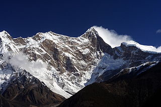
Kangchenjunga, also spelled Kanchenjunga, Kanchanjanghā and Khangchendzonga, is the third-highest mountain in the world. Its summit lies at 8,586 m (28,169 ft) in a section of the Himalayas, the Kangchenjunga Himal, which is bounded in the west by the Tamur River, in the north by the Lhonak River and Jongsang La, and in the east by the Teesta River. It lies in the border region between Koshi Province of Nepal and Sikkim state of India, with the two peaks West and Kangbachen in Nepal's Taplejung District and the other three peaks Main, Central and South directly on the border.

The Brahmaputra is a trans-boundary river which flows through Southwestern China, Northeastern India, and Bangladesh. It is known as Brahmaputra or Luit in Assamese, Yarlung Tsangpo in Tibetan, the Siang/Dihang River in Arunachali, and Jamuna River in Bengali. By itself, it is the 9th largest river in the world by discharge, and the 15th longest.
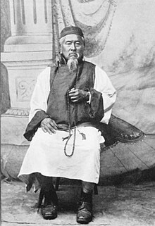
Nain Singh, also known as Nain Singh Rawat, was one of the first Indian explorers employed by the British to explore the Himalayas and Central Asia. He came from the Johar Valley in Kumaon. He surveyed the trade route through Ladakh to Tibet, determined the location and altitude of Lhasa in Tibet, and surveyed a large section of Brahmaputra. His reports were initially made under the code name Number 9. He walked "1,580 miles, or 3,160,000 paces, each counted."

The Yarlung Tsangpo Grand Canyon, also known as the Yarlung Zangbo Grand Canyon, the Tsangpo Canyon, the Brahmaputra Canyon or the Tsangpo Gorge, is a canyon along the Yarlung Tsangpo River in Tibet Autonomous Region, China. It is the deepest canyon in the world, and at 504.6 kilometres (313.5 mi) is slightly longer than the Grand Canyon in the United States, making it one of the world's largest. The Yarlung Tsangpo originates near Mount Kailash and runs east for about 1,700 kilometres (1,100 mi), draining a northern section of the Himalayas before it enters the gorge just downstream of Pei, Tibet, near the settlement of Zhibe. The canyon has a length of about 240 kilometres (150 mi) as the gorge bends around Mount Namcha Barwa and cuts its way through the eastern Himalayas. Its waters drop from about 2,900 metres (9,500 ft) near Pei to about 1,500 metres (4,900 ft) at the end of the Upper Gorge where the Po Tsangpo River enters. The river continues through the Lower Gorge to the Indian border at an elevation of 660 metres (2,170 ft). The river then enters Arunachal Pradesh and eventually becomes the Brahmaputra.
Jelep La elevation 14,390 feet (4,390 m), is a high mountain pass between Sikkim, India and Tibet Autonomous Region, China. It is on a route that connects Lhasa to India. The pass is about 4 km (2.5 mi) south of Nathu La and is slightly higher. It was frequently used for trade between Tibet and India during the British Raj, with Kalimpong serving as the contact point. The Menmecho Lake lies below the Jelep La.

The history of Sikkim begins with the indigenous Lepcha's contact with early Tibetan settlers. Historically, Sikkim was a sovereign Monarchical State in the eastern Himalayas. Later a protectorate of India followed by a merger with India and official recognition as a state of India. Lepchas were the main inhabitants as well as the Rulers of the land up to 1641. Lepchas are generally considered to be the first people, Indigenous to Sikkim also includes Darjeeling.
The term pundit was used in the second half of the 19th century to denote native Indian surveyors used by the British to secretly explore regions north of British India. The Pundit was the code-name for one of the first native explorers, Nain Singh, who was originally a schoolteacher. His accomplishments were so remarkable that the whole group of around twenty native explorers became known as the Pundits.

Frederick Marshman Bailey was a British political officer and one of the last protagonists of The Great Game. His expeditions in Tibet and Assam Himalaya gave him many opportunities to pursue his hobbies of photography, butterfly collecting and trophy hunting in the high Tibetan region. Over 2000 of his bird specimens were presented to the Natural History Museum, although his personal collection is now held in the American Museum of Natural History, New York. His papers and extensive photograph collections are held in the British Library, London.
Namcha Barwa or Namchabarwa is a mountain peak lying in Tibet in the region of Pemako. The traditional definition of the Himalaya extending from the Indus River to the Brahmaputra would make it the eastern anchor of the entire mountain chain, and it is the highest peak of its own section as well as Earth's easternmost peak over 7,600 metres (24,900 ft). It lies in the Nyingchi Prefecture of Tibet. It is the highest peak in the 180 km long Namcha Barwa Himal range, which is considered the easternmost syntaxis/section of the Himalaya in southeastern Tibet and northeastern India where the Himalaya are said to end, although high ranges actually continue another 300 km to the east.

The Yarlung Tsangpo, also called Yarlung Zangbo and Yalu Zangbu River is a river that flows through the Tibet Autonomous Region of China and Arunachal Pradesh of India. It is the longest river of Tibet and the fifth longest in China. The upper section is also called Dangque Zangbu meaning "Horse River".

Yatung or Yadong, also known as Shasima , is the principal town in the Chumbi Valley or Yadong County in the Tibet Autonomous Region of China. It is also its administrative headquarters.

The Eastern Himalayan alpine shrub and meadows is a montane grasslands and shrublands ecoregion of Bhutan, China, India, Myanmar, and Nepal, which lies between the tree line and snow line in the eastern portion of the Himalaya Range.

Henry Treise Morshead was an English surveyor, explorer and mountaineer. He is remembered for several achievements – with Frederick Bailey he explored the Tsangpo Gorge and finally confirmed that the Yarlung Tsangpo flows into the Brahmaputra River after cascading through Himalaya; also he was a member of the 1921 and 1922 British Mount Everest expeditions and in 1922 he climbed to a height of over 25,000 feet (7,600 m). His death was due to murder and the circumstances remain mysterious.

Alexander Macmillan Heron was a Scottish geologist who became Director of the Geological Survey of India. He participated in the 1921 British Mount Everest reconnaissance expedition following which he produced a geological map of the Everest region of Tibet.
John de Vars Hazard MC was a British Army officer and mountaineer who took part in the 1924 British Mount Everest expedition, most famous for the disappearance of the mountaineers George Mallory and Andrew "Sandy" Irvine.
The Bailey–Morshead exploration of the Tsangpo Gorge was an unauthorised expedition by Frederick Bailey and Henry Morshead in 1913 which for the first time established the definite route by which the Tsangpo River reaches the sea from north of Himalaya, through the Tsangpo Gorge.

The Affair of the Dancing Lamas was an Anglo–Tibetan diplomatic controversy stemming mainly from the visit to Britain in 1924–25 of a party of Tibetan monks as part of a publicity stunt for The Epic of Everest – the official film of the 1924 British Mount Everest Expedition.

Chumbi is a historic village in the Chumbi Valley or the Yadong County of the Tibet Autonomous Region of China. It is in the valley of the Amo Chu River, where the route from Sikkim's Cho La Pass meets the Amo Chu Valley. The "Chumbi Valley" of the European nomenclature derives its name from the village of Chumbi. It was the administrative center of the lower Chumbi Valley until the Chinese take-over of Tibet in 1950, after which Yatung became its headquarters. Chumbi is also associated with the Sikkim's royal family, which had a summer palace in the village.
The Nyamjang Chu, or Nyashang Chu (Tibetan: ཉ་བཤང་ཆུ, Wylie: nya bshang chu, THL: nya shang chu) is a cross-border perennial river that originates in the Shannan Prefecture of Tibet and flows into the Arunachal Pradesh state of India, joining the Tawang Chu river just before it enters Bhutan. The Nyamjang Chu valley has provided the traditional communication route between Tawang and Tibet. The valley near the town of Zemithang in the Tawang district, called the Pangchen Valley, is known for its serene beauty and forms one of the wintering locations for the black-necked crane.
Henry John Harman was a Royal Engineers officer who was involved in surveys in the Himalayas of northeastern India as part of the Great Trigonometrical Survey. He was involved in recruiting and organizing "pandit" explorers to trace out the upper Brahmaputra river and to discover if it was the same as the Tsang-Po. A pheasant species Crossoptilon harmani was named after him and was for sometime called as Harman's pheasant.