Henricus Martellus Germanus

Last updated
Map of the world by Henricus Martellus Germanus, preserved in the British Library World map by Martellus - Account of the Islands of the Mediterranean (1489), ff.68v-69 - BL Add MS 15760.jpg
Map of the world by Henricus Martellus Germanus, preserved in the British Library
Map of the world by Henricus Martellus Germanus, preserved at Yale University Martellus-Yale.jpg
Map of the world by Henricus Martellus Germanus, preserved at Yale University

Henricus Martellus Germanus (fl. 1480-1496) was a German cartographer active in Florence between 1480 and 1496. His surviving cartographic work includes manuscripts of Ptolemy's Geographia, manuscripts of Insularium illustratum (a descriptive atlas of island maps), and two world maps which were the first to show a passage around the southern tip of Africa into the Indian Ocean. His world maps summarize geographical knowledge at the outset of the Age of Discovery and "epitomize the best of European cartography at the end of the fifteenth century." [1]

Contents

Biography

Very little is known about the life of Henricus Martellus Germanus. Even his name and place of birth have been the subject of much speculation. In the fifteenth century it was common for scholars and artisans to adopt a Latinized version of their birth name. This was the case with Martellus. Germanus is the Latin word for Germany and it is the clearest indication of his origin. Some authors have assumed his birth name must have been "Heinrich Hammer" (the German translation of Henricus Martellus), but there is no documentary proof. It is possible that he was from Nuremberg, a center of the German Renaissance but, again, no direct evidence. [2]

At the time, Florence was home to a significant population of German immigrants working as craftsmen and artisans, so Martellus's presence in the city would not have been remarkable. He was active in Florence between 1480 and 1496, spending at least some of that time in the workshop of Francesco Rosselli. [3] [4]

Nothing is known of his education or experience, although his work shows some influence of Nicolaus Germanus, another German cartographer active in Florence. [5] His own assertion that he traveled extensively suggests that perhaps he was a merchant. [6]

Works

The surviving cartographic works attributed to Martellus include two world maps, manuscripts of Ptolemy's Geographia, and manuscripts of Insularium illustratum (a descriptive atlas of island maps). [7]

World maps

Between around 1489 and 1491, he produced at least one world map which is remarkably similar to the terrestrial globe produced by Martin Behaim around 1492, the Erdapfel . Both show novel adaptations of the existing Ptolemaic model, opening a passage south of Africa and creating an enormous new peninsula east of the Golden Chersonese (Malaysia). Both possibly derive from maps created around 1485 in Lisbon by Bartolomeo Columbus.[ citation needed ]

A manuscript world map, measuring 201 by 122 centimetres (79 in × 48 in) in size, was rediscovered in the 1960s [8] and donated to Yale's Beinecke Rare Book and Manuscript Library. [9] An inscription in the lower left corner states: "Although Strabo and Ptolemy and the majority of the ancients were most assiduous in describing the world we, however, bring together in this picture and carefully show in their true places the new knowledge that escaped their diligence and remained unknown to them". [10] Another world map by Henricus Martellus Germanus is in the British Library's collection. [11]

A 2014 multispectral imaging project led by Chet van Duzer revealed many previously illegible details of the map, including a depiction of a porcupine in northern Asia, references to mythological peoples such as the Hippopodes and the Panotti, and a surprising amount of information about the interior of Africa – knowledge that likely originated with the Ethiopian delegation to the 1441 Council of Florence. [12]

Ptolemy's Geographia

Around 1480, Martellus produced his earliest known work, a manuscript of Ptolemy's Geographia. This first version followed the standard Ptolemaic model, a traditional world map and twenty-six regional maps using a trapezoidal projection. A later version was produced for his patron, Camillo Maria Vitelli. In addition to the traditional maps, Martellus added a number of new maps (tabulae modernae) including maps of Mediterranean islands, Asia Minor, northern Europe, the British Isles and a nautical map of the north African coast. In a preface he claims his maps contain all the ports and coasts newly discovered by the Portuguese. [13]

Insularium illustratum

Martellus also produced an Insularium illustratum ("Illustrated Book of Islands") of which five manuscripts are extant, plus one working copy in the Biblioteca Laurentiana. It contains an illustrated description of islands of the Aegean Sea, mostly copied from a previous work by Cristoforo Buondelmonti. Buondelmonti's isolario (island book) had been copied many times during the 15th-century but Martellus added other Mediterranean islands such as Corsica, Sardinia and Sicily to his version, and he was the first to add islands outside of the Mediterranean, including Britain and Ireland. He was also the first to add several regional maps and a world map. In particular, the British Library manuscript contains his most important, detailed, and widely reproduced world map. [14] [15]

Influence

Martellus' map served as one source for the Waldseemüller map of 1507. The overall layout was similar, and Martin Waldseemüller used the same projection as Martellus, the pseudo-cordiform projection. Both cartographers added decorative wind-heads in the borders of their maps, and both also took advantage of the extra space in the lower corners of the maps created by the swooping lines of the projection to add text blocks in those corners. The shape of northern Africa is the same on both maps; that is, it is Ptolemaic with a sharp northwestern corner. The shape of eastern Asia is also similar on the two maps, with a huge peninsula jutting southwestward into the Indian Ocean, and Japan is in precisely the same position on the two maps, at the eastern edge. [16]

He has been identified with an Arrigho di Federigho who authored the first translation into German of Bocaccio's Decamerone . According to this theory, the surname Martellus comes from the Martelli family, to which Henricus/Arrigho was linked. [17]

Henricus Martellus, explanatory inscription on his world map of 1491 Martellus 1491 inscription.tif
Henricus Martellus, explanatory inscription on his world map of 1491

Notes

  1. Edson 2007, p. 219
  2. Van Duzer 2019, p. 3
  3. Van Duzer 2019, p. 3
  4. Edson 2007, pp. 215-220
  5. Van Duzer 2019, p. 3
  6. Edson 2007, pp. 215-220
  7. Van Duzer 2019, p. 4
  8. Urbanus, Jason (Jan–Feb 2016). "Reading the Invisible Ink". Archaeology. 69 (1): 9–10. ISSN   0003-8113 . Retrieved 11 January 2021.
  9. Hammer, Heinrich. "Map of the world of Christopher Columbus". Beinecke Rare Book & Manuscript Library. Yale University. Retrieved 31 August 2017.; Chet Van Duzer, Henricus Martellus's World Map at Yale (c. 1491): Multispectral Imaging, Sources, and Influence, Berlin, Springer International Publishing, 2018.
  10. ETSI STRABO AC PTOLEMEUS ET PLERIQUE VETERUM DESCRIBENDI ORBIS FUERE STUDIOSISSIMI NOVORUM TAMEN DILIGENTIA QUEDAM AB EIS TANQUAM INCOGNITA PRETERMISSA ADINVENIT QUE NOS HOC PICTURE AD VERAM LOCORUM SCIENTIAM EXPRIMENDAM STUDIOSE IUNXIMUS
  11. British Library
  12. Miller, Greg (8 October 2018). "A 500-year-old map used by Columbus reveals its secrets". National Geographic. Archived from the original on October 26, 2018. Retrieved 26 August 2019.
  13. Edson 2007, pp. 215-220
  14. Van Duzer 2019, pp. 9-18
  15. Bouloux, Nathalie (2012). "L'Insularium Illustratum d'Henricus Martellus". The Historical Review / La Revue Historique. IX: 77–94. Retrieved 30 September 2016.
  16. Chet Van Duzer, "Waldseemüller's World Maps of 1507 and 1516: Sources and Development", The Portolan, No.1, Winter 2012, p.12.
  17. Rezension von L. Böninger: Die deutsche Einwanderung nach Florenz (2006)

Related Research Articles

<span class="mw-page-title-main">Martin Waldseemüller</span> German cartographer and scholar

Martin Waldseemüller was a German cartographer and humanist scholar. Sometimes known by the Latinized form of his name, Hylacomylus, his work was influential among contemporary cartographers. His collaborator Matthias Ringmann and he are credited with the first recorded usage of the word America to name a portion of the New World in honour of Italian explorer Amerigo Vespucci in a world map they delineated in 1507. Waldseemüller was also the first to map South America as a continent separate from Asia, the first to produce a printed globe, and the first to create a printed wall map of Europe. A set of his maps printed as an appendix to the 1513 edition of Ptolemy's Geography is considered to be the first example of a modern atlas.

<span class="mw-page-title-main">Martin Behaim</span> German cartographer

Martin Behaim, also known as Martin von Behaim and by various forms of Martin of Bohemia, was a German textile merchant and cartographer. He served John II of Portugal as an adviser in matters of navigation and participated in a voyage to West Africa. He is now best known for his Erdapfel, the world's oldest known globe, which he produced for the Imperial City of Nuremberg in 1492.

<span class="mw-page-title-main">Claudius Clavus</span> Danish geographer

Claudius Clavus (Suartho) also known as Nicholas Niger,, , was a Danish geographer sometimes considered to be the first Nordic cartographer.

<i>Terra incognita</i> "Unknown land", area not mapped by cartographers

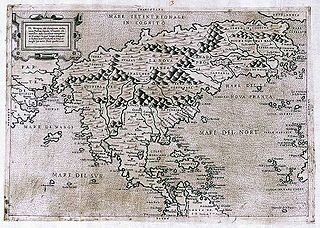
Terra incognita or terra ignota is a term used in cartography for regions that have not been mapped or documented. The expression is believed to be first seen in Ptolemy's Geography c. 150. The term was reintroduced in the 15th century from the rediscovery of Ptolemy's work during the Age of Discovery. The equivalent on French maps would be terres inconnues, and some English maps may show Parts Unknown.

<span class="mw-page-title-main">Here be dragons</span> Phrase used on maps to indicate uncharted areas

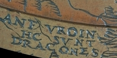
"Here be dragons" means dangerous or unexplored territories, in imitation of a medieval practice of putting illustrations of dragons, sea monsters and other mythological creatures on uncharted areas of maps where potential dangers were thought to exist.

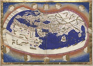
The earliest known world maps date to classical antiquity, the oldest examples of the 6th to 5th centuries BCE still based on the flat Earth paradigm. World maps assuming a spherical Earth first appear in the Hellenistic period. The developments of Greek geography during this time, notably by Eratosthenes and Posidonius culminated in the Roman era, with Ptolemy's world map, which would remain authoritative throughout the Middle Ages. Since Ptolemy, knowledge of the approximate size of the Earth allowed cartographers to estimate the extent of their geographical knowledge, and to indicate parts of the planet known to exist but not yet explored as terra incognita.

<i>Geography</i> (Ptolemy) Treatise on cartography by Claudius Ptolemaeus

The Geography, also known by its Latin names as the Geographia and the Cosmographia, is a gazetteer, an atlas, and a treatise on cartography, compiling the geographical knowledge of the 2nd-century Roman Empire. Originally written by Claudius Ptolemy in Greek at Alexandria around AD 150, the work was a revision of a now-lost atlas by Marinus of Tyre using additional Roman and Persian gazetteers and new principles. Its translation into Arabic in the 9th century was highly influential on the geographical knowledge and cartographic traditions of the Islamic world. Alongside the works of Islamic scholars - and the commentary containing revised and more accurate data by Alfraganus - Ptolemy's work was subsequently highly influential on Medieval and Renaissance Europe.

<span class="mw-page-title-main">Waldseemüller map</span> 1507 German world map

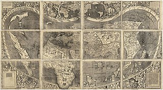
The Waldseemüller map or Universalis Cosmographia is a printed wall map of the world by German cartographer Martin Waldseemüller, originally published in April 1507. It is known as the first map to use the name "America". The name America is placed on South America on the main map. As explained in Cosmographiae Introductio, the name was bestowed in honor of the Italian Amerigo Vespucci.

The Johannes Schöner globes are a series of globes made by Johannes Schöner (1477–1547), the first being made in 1515. Schöner's globes are some of the oldest still in existence. Some of them are said by some authors to show parts of the world that were not yet known to Europeans, such as the Magellan Strait and the Antarctic.

<span class="mw-page-title-main">Francesco Berlinghieri</span>

Francesco Berlinghieri (1440–1501) was an Italian scholar and humanist who lived during the fifteenth century. He promoted the value of classical Greek learning and was one of the first to print a text based on Ptolemy's Geographica. Berlinghieri studied poetry under the tutelage of Cristoforo Landino.

<span class="mw-page-title-main">Francesco Rosselli</span> Italian painter

Francesco Rosselli was an Italian miniature painter, and engraver of maps and old master prints. He was described as a cartographer, although his contribution did not include any primary research and was probably limited to engraving, decorating and selling manuscript maps created by others. He created many maps, including one of the first printed maps of the world to incorporate the discoveries of Christopher Columbus in the Americas. The attribution of prints to him is the subject of debate, as different engraving styles are used. This may be the result of different artists in his workshop, or of his and his shop's ability to use different styles.

<span class="mw-page-title-main">Nicolaus Germanus</span> German cartographer

Nicolaus Germanus was a German cartographer who modernized Ptolemy's Geography by applying new projections, adding additional maps, and contributing other innovations that were influential in the development of Renaissance cartography.

<span class="mw-page-title-main">Globus Jagellonicus</span> French globe

The Jagiellonian globe, also known as the Globus Jagellonicus, is a mechanical armillary sphere made in France before 1510. It is an astronomical instrument and a universal clock tracking both local solar time and sidereal time. The central brass sphere is engraved with a map of Earth and contains the clock mechanism. It is the oldest extant globe to use the name America.

<span class="mw-page-title-main">Panotti</span> Mythical race of people

The Panotti were a mythical race of people, described as possessing large ears that covered their entire bodies.

Cartographic censorship is the deliberate modification of publicly available maps in order to disguise, remove, or obfuscate potentially strategic locations or buildings, such as military bases, power plants or transmitters. Sensitive objects and places have been removed from maps since historic times, sometimes as a disinformation tactic in times of war, and also to serve competitive political and economic interests, such as during the Age of Discovery when strategic geographic information was highly sought after. In modern times requests for censorship are sent to Google Earth for certain sites that are deemed to pose security risks for national governments.

Hippopodes, meaning "horse-footed," is an allegorical creature in Greek mythology that is often associated with greed. According to the myth, the Hippopodes were a tribe of beings with the lower bodies of horses and the upper bodies of men. They were said to have guarded a fabulous treasure, but their insatiable greed made them unwilling to share it with anyone. This greed ultimately led to their downfall. The allegory of the Hippopodes serves as a cautionary tale against the dangers of greed and avarice.

The Dragon's Tail is a modern name for the phantom peninsula in southeast Asia which appeared in medieval Arabian and Renaissance European world maps. It formed the eastern shore of the Great Gulf east of the Golden Chersonese, replacing the "unknown lands" which Ptolemy and others had thought surrounded the "Indian Sea".

Chet Van Duzer is an American historian of cartography.

Historia rerum ubique gestarum locorumque descriptio is an unfinished book written by Enea Silvio Piccolomini, who was later elected Pope Pius II in 1458. It was written originally in Latin, and the title roughly translates to "History of Achievements Everywhere." The original intent of the book was to record the history of human existence across the globe, as well as a historical and geographical cosmography. Piccolomini planned three sections, on Europe, Asia, and Africa. Only the sections on Europe and Asia were completed in 1458 and 1461, respectively. The incomplete book was published in Venice in 1477 after his death, as Historia rerum ubique gestarum. The published version of the book also told the work of Eratosthenes on the size of the earth and was very heavily read and annotated by Christopher Columbus on his voyages. Columbus used this as one of the many works from which he pulled his ideas about the Earth. The copy that was used by Columbus to prepare for his voyages, along with his annotations, is now kept in the Columbine Library in Seville Cathedral in Seville, Spain. Historia rerum ubique gestarum has been translated into many different languages today, and copies of the book can sell for up to $2,200 USD.

References