Martin Behaim

Last updated • 6 min readFrom Wikipedia, The Free Encyclopedia
Martin Behaim
Martin Behaim Winsor.jpg
Martin Behaim. Engraving from Narrative and Critical History of America, Volume 2 by Justin Winsor
Born6 October 1459  OOjs UI icon edit-ltr-progressive.svg
Nuremberg (Holy Roman Empire)  OOjs UI icon edit-ltr-progressive.svg
Died29 July 1507  OOjs UI icon edit-ltr-progressive.svg (aged 47)
Lisbon (Kingdom of Portugal)  OOjs UI icon edit-ltr-progressive.svg

Martin Behaim (6 October 1459 – 29 July 1507), also known as Martin von Behaim and by various forms of Martin of Bohemia, was a German textile merchant and cartographer. He served John II of Portugal as an adviser in matters of navigation and participated in a voyage to West Africa. He is now best known for his Erdapfel, the world's oldest known globe, which he produced for the Imperial City of Nuremberg in 1492.

Contents

Biography

Monument of Martin Behaim in the Theresienplatz, Nuremberg Nuernberg-behaim-denkmal-v-so.jpg
Monument of Martin Behaim in the Theresienplatz, Nuremberg

Behaim was born in Nuremberg on 6 October 1459, the oldest son of Martin Behaim and Agnes Schopper. The elder Martin was a merchant involved in long-distance trade within Europe, including Venice; in 1461 he was elected a senator of Nuremberg. Their son, as a member of a prominent and prosperous family, likely received a good education at one of the best grammar schools in the city. Contrary to later assertions, it is unlikely that he was ever a student of the famous Renaissance mathematician and astronomer, Regiomontanus. [1] [2]

When his father died in 1474, Martin's uncle Leonhard sent him at 15 to Mechelen, Flanders to gain experience as a textile merchant. There he joined the business of Jorius van Dorpp, a vendor of clothing. In 1477 they visited Antwerp where van Dorpp sold his wares to a German merchant; later that same year Behaim attended the Frankfurt fair with Bartels von Eyb, a friend of the family. Writing to his uncle in 1478, Behaim expressed a desire to improve his business prospects by moving to Antwerp, a leading center of the cloth trade. The following year he moved to Antwerp and joined the cloth dye house of Fritz Heberlein, a native of Nuremberg. [2]

In 1484 Behaim moved to Portugal and set up residence in Lisbon. The circumstances behind this move are unclear but Lisbon was the hub of a wide-ranging trade network that included spices, slaves, and gold from Africa and Behaim was likely looking for trading opportunities. [1] He quickly found favor as a counselor in the court of King John II where he supposedly provided advice on navigation and astronomy. However, despite assertions by his early biographers, there is no evidence that Behaim made any significant contributions in these areas. Claims that he taught celestial navigation or introduced the Portuguese to new navigational instruments are belied by the fact that these technologies were already known and used by Portuguese mariners. He may have acted as an importer of scientific instruments, the finest of which were produced at that time in his native town of Nuremberg. [1] [2]

On 18 February 1485 Behaim was knighted by John II, presumably for his contributions as adviser on navigation and astronomy but there is no record of the exact reasons for his honor. [2]

It appears that Behaim participated in a voyage to West Africa around 1485; however it is unlikely that he accompanied Diogo Cão on his second expedition as is sometimes claimed. [3] It is more likely that he participated in a trading voyage to Guinea led by João Afonso de Aveiro. [2]

Following his marriage to Joana de Macedo in 1486, he resided on the Portuguese island of Faial in the Azores, where his father-in-law, Josse van Huerter, was Captain-donatário and leader of the Flemish community. In 1490, Behaim returned to Nuremberg to settle a will case, and remained in the city for three years. He managed to convince leading members of the city council to finance the construction of his famous terrestrial globe under his direction. [1] He returned to Faial in 1493 by way of Flanders and Lisbon, and he remained there until 1506. [2]

Behaim died in the hospice of Saint Bartholomew on 29 July 1507 while visiting Lisbon for business. [1]

Unsubstantiated claims

Numerous assertions have been made regarding Behaim's accomplishments, some made by himself and others by his early biographers. Since the twentieth century, historians have taken a more critical look at these claims and have concluded that many of them are unsubstantiated by any documentary evidence, and in some cases flatly contradicted by existing documentation. [1] [2] [4]

Historian Johann Christoph Wagenseil claimed in 1682 that Behaim had discovered America before Columbus. Other authors say that Behaim at least gave Columbus the idea of sailing west. There is no evidence that Behaim ever sailed west on a voyage of discovery and although it is possible that Behaim and Columbus met in Lisbon, neither Behaim or Columbus ever referenced such a meeting. [4]

Behaim has been hailed as a great mathematician and astronomer but there is no evidence of a scientific education nor are there any extant scientific writings by him. Behaim claimed to be a disciple of the Renaissance mathematician and astronomer, Regiomontanus. Regiomontanus was a neighbor in Nuremberg when Behaim was a boy, but there is no evidence that they ever studied together.

Biographers have claimed that Behaim accompanied Diogo Cão on his second voyage of discovery. Behaim may have contributed to the misunderstanding by leaving a confused account of an African voyage he made in 1485. The fact is that Behaim's dates do not match the dates of this voyage and there is no independent evidence that Behaim sailed with Cão. [4]

Antonio Pigafetta, an Italian writer who accompanied Ferdinand Magellan alleges that Magellan had prior knowledge of a passage to the "Southern Sea" derived from a map made by Behaim. Historians now doubt that Behaim had any direct knowledge of such a passage but he may have depicted mysterious passages in an unknown land which Magellan interpreted as the strait he eventually discovered.

Behaim globe

Martin Behaim, eastern hemisphere of his globe made in Nuremberg in 1492. Friedrich Wilhlem Ghillany, Geschichte des Seefahrers Ritter Martin Behaim, Nurnberg, Bauer und Raspe, J. Merz, 1853. Behaim Eastern Hemisphere.jpg
Martin Behaim, eastern hemisphere of his globe made in Nuremberg in 1492. Friedrich Wilhlem Ghillany, Geschichte des Seefahrers Ritter Martin Behaim, Nürnberg, Bauer und Raspe, J. Merz, 1853.
The Nuremberg Globe of Martin Behaim Behaims Erdapfel.jpg
The Nuremberg Globe of Martin Behaim
Martin Behaim, western hemisphere of his globe made in Nuremberg in 1492. Friedrich Wilhlem Ghillany, Geschichte des Seefahrers Ritter Martin Behaim, Nurnberg, Bauer und Raspe, J. Merz, 1853. Behaim Western Hemisphere.jpg
Martin Behaim, western hemisphere of his globe made in Nuremberg in 1492. Friedrich Wilhlem Ghillany, Geschichte des Seefahrers Ritter Martin Behaim, Nürnberg, Bauer und Raspe, J. Merz, 1853.
Detail of the Atlantic Ocean envisioned by Martin Behaim Martin Behaim 1492 Ocean Map.png
Detail of the Atlantic Ocean envisioned by Martin Behaim

After Behaim returned to Nuremberg in 1490, leading members of the city council financed the construction of a terrestrial globe. Under the direction of Behaim, a team of artisans and craftsmen constructed what has become the oldest extant globe. Georg Glockendon was the artist who created the actual map drawings following Behaim's specifications. [2]

The globe is about 21 inches (51 cm) in diameter and was fashioned from a type of papier-mache and coated with gypsum. The ball was supported on a wooden tripod and secured by a pair of iron hoops. Glockendon's map drawings were painted onto parchment strips and pasted into position around the sphere. The globe contains more than 2,000 place names, 100 pictorial illustrations (plus 48 banners and 15 coats of arms), and more than 50 long legends. Many of the notations deal with fabulous monsters of foreign countries and their inhabitants, plants and animals. Many notes also deal with trade, explorations, and famous travelers like Marco Polo. [5]

The world map depicted on the Behaim globe is based primarily on the geography of the second-century geographer Ptolemy. It also combines geographical information from other sources, including Marco Polo, John Mandeville, and Portuguese explorer Diogo Gomes. It is notable for lacking more current Portuguese geographic data which should have been available to Behaim and it contains numerous errors that did not reflect contemporary geographical understanding. [1]

The completed globe, which came to be called Erdapfel (earth apple) by the townspeople, was originally housed in Nuremberg's city hall. In the 17th century the Behaim family took possession of the globe. It was inexpertly restored in 1823 and again in 1847, resulting in the corruption of many place-names and labels. The German National Museum in Nuremberg later took possession of the globe, which is commonly known as the Nuremberg Terrestrial Globe.

The antiquity of this globe and the year of its execution, on the eve of the discovery of the Americas, makes it not just the oldest globe but also represents an encyclopedia of Europe's knowledge of the known world in 1492.

Comparison of coastal outlines on maps of Juan de la Cosa and Martin Behaim with the true coastline Conceptions Colomb map-en.svg
Comparison of coastal outlines on maps of Juan de la Cosa and Martin Behaim with the true coastline

See also

Related Research Articles

<span class="mw-page-title-main">Amerigo Vespucci</span> Italian explorer and navigator (1454–1512)

Amerigo Vespucci was an Italian explorer and navigator from the Republic of Florence for whom "America" is named.

<span class="mw-page-title-main">Diogo Cão</span> Portuguese explorer (1452–1486)

Diogo Cão, also known as Diogo Cam, was a Portuguese mariner and one of the most notable explorers of the fifteenth century. He made two voyages along the west coast of Africa in the 1480s, exploring the Congo River and the coasts of present-day Angola and Namibia.

<span class="mw-page-title-main">Prince Henry the Navigator</span> Portuguese prince and governor (1394–1460)

Dom Henrique of Portugal, Duke of Viseu, better known as Prince Henry the Navigator, was a central figure in the early days of the Portuguese Empire and in the 15th-century European maritime discoveries and maritime expansion. Through his administrative direction, he is regarded as the main initiator of what would be known as the Age of Discovery. Henry was the fourth child of King John I of Portugal, who founded the House of Aviz.

<span class="mw-page-title-main">Globe</span> Scale model of a celestial body

A globe is a spherical model of Earth, of some other celestial body, or of the celestial sphere. Globes serve purposes similar to maps, but, unlike maps, they do not distort the surface that they portray except to scale it down. A model globe of Earth is called a terrestrial globe. A model globe of the celestial sphere is called a celestial globe.

<span class="mw-page-title-main">Age of Discovery</span> Period of European global exploration from the 15th century to the 17th century

The Age of Discovery, also known as the Age of Exploration, was part of the early modern period and largely overlapped with the Age of Sail. It was a period from approximately the late 15th century to the 17th century, during which seafarers from a number of European countries explored, colonized, and conquered regions across the globe. The Age of Discovery was a transformative period in world history when previously isolated parts of the world became connected to form the world-system and laid the groundwork for globalization. The extensive overseas exploration, particularly the opening of maritime routes to the Indies and the European colonization of the Americas by the Spanish and Portuguese, later joined by the English, French and Dutch, spurred in the International global trade. The interconnected global economy of the 21st century has its origins in the expansion of trade networks during this era.

<span class="mw-page-title-main">Antillia</span> 15th-century phantom island

Antillia is a phantom island that was reputed, during the 15th-century age of exploration, to lie in the Atlantic Ocean, far to the west of Portugal and Spain. The island also went by the name of Isle of Seven Cities.

<span class="mw-page-title-main">New World</span> Synonym for the Americas

The term "New World" is used to describe the majority of lands of Earth's Western Hemisphere, particularly the Americas. The term arose in the early 16th century during Europe's Age of Discovery, after Italian explorer Amerigo Vespucci published the Latin-language pamphlet Mundus Novus, presenting his conclusion that these lands constitute a new continent.

The earliest known world maps date to classical antiquity, the oldest examples of the 6th to 5th centuries BCE still based on the flat Earth paradigm. World maps assuming a spherical Earth first appear in the Hellenistic period. The developments of Greek geography during this time, notably by Eratosthenes and Posidonius culminated in the Roman era, with Ptolemy's world map, which would remain authoritative throughout the Middle Ages. Since Ptolemy, knowledge of the approximate size of the Earth allowed cartographers to estimate the extent of their geographical knowledge, and to indicate parts of the planet known to exist but not yet explored as terra incognita.

<span class="mw-page-title-main">Diogo Gomes</span> Portuguese navigator

Diogo Gomes was a Portuguese navigator, explorer and writer. Diogo Gomes was a servant and explorer of Portuguese prince, Henry the Navigator. His memoirs were dictated late in his life to Martin Behaim. They are an invaluable account of the Portuguese discoveries under Prince Henry the Navigator, and one of the principal sources upon which historians of the era have drawn. He explored and ascended up the Gambia River in West Africa and discovered some of the Cape Verde islands.

<span class="mw-page-title-main">Waldseemüller map</span> 1507 German world map

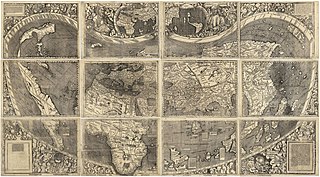
The Waldseemüller map or Universalis Cosmographia is a printed wall map of the world by German cartographer Martin Waldseemüller, originally published in April 1507. It is known as the first map to use the name "America". The name America is placed on South America on the main map. As explained in Cosmographiae Introductio, the name was bestowed in honor of the Italian Amerigo Vespucci.

The Johannes Schöner globes are a series of globes made by Johannes Schöner (1477–1547), the first being made in 1515. Schöner's globes are some of the oldest still in existence. Some of them are said by some authors to show parts of the world that were not yet known to Europeans, such as the Magellan Strait and the Antarctic.

<span class="mw-page-title-main">Henricus Martellus Germanus</span> German cartographer

Henricus Martellus Germanus was a German cartographer active in Florence between 1480 and 1496. His surviving cartographic work includes manuscripts of Ptolemy's Geographia, manuscripts of Insularium illustratum, and two world maps which were the first to show a passage around the southern tip of Africa into the Indian Ocean. His world maps summarize geographical knowledge at the outset of the Age of Discovery and "epitomize the best of European cartography at the end of the fifteenth century."

<span class="mw-page-title-main">Erdapfel</span> Oldest surviving terrestrial globe (1490~1492)

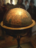
The Erdapfel is a terrestrial globe 51 cm (20 in) in diameter, produced by Martin Behaim from 1490 to 1492. The Erdapfel is the oldest surviving terrestrial globe. It is constructed of a laminated linen ball in two halves, reinforced with wood and overlaid with a map painted on gores by Georg Glockendon. These intricate details were based on navigational charts by Jorge de Aguiar, incorporating paper maps meticulously pasted onto a parchment layer encircling the globe.

Johannes Ruysch, a.k.a. Johann Ruijsch or Giovanni Ruisch was an explorer, cartographer, astronomer, manuscript illustrator and painter from the Low Countries who produced a famous map of the world: the second oldest known printed representation of the New World. This Ruysch map was published and widely distributed in 1507.

<span class="mw-page-title-main">Globus Jagellonicus</span> French globe

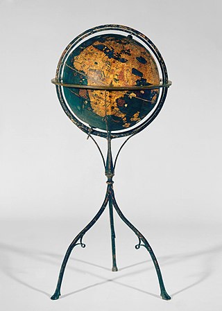
The Jagiellonian globe, also known as the Globus Jagellonicus, is a mechanical armillary sphere made in France before 1510. It is an astronomical instrument and a universal clock tracking both local solar time and sidereal time. The central brass sphere is engraved with a map of Earth and contains the clock mechanism. It is the oldest extant globe to use the name America.

<span class="mw-page-title-main">Erhard Etzlaub</span> German cartographer (c. 1455–1532)

Erhard Etzlaub was a German cartographer, astronomer, geodesist, instrument maker, and physician.

<span class="mw-page-title-main">History of the Azores</span>

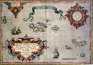
The following article describes the history of the Azores, an archipelago composed of nine volcanic islands in the Macaronesia region of the North Atlantic Ocean, about 1,400 km (870 mi) west of Lisbon, about 1,500 km (930 mi) northwest of Morocco, and about 1,930 km (1,200 mi) southeast of Newfoundland, Canada.

<span class="mw-page-title-main">Portuguese maritime exploration</span> Numerous territories and maritime routes recorded by the Portuguese

Portuguese maritime exploration resulted in the numerous territories and maritime routes recorded by the Portuguese as a result of their intensive maritime journeys during the 15th and 16th centuries. Portuguese sailors were at the vanguard of European exploration, chronicling and mapping the coasts of Africa and Asia, then known as the East Indies, and Canada and Brazil, in what came to be known as the Age of Discovery.

Hieronymus Münzer or Monetarius was a Renaissance humanist, physician and geographer who made a famous grand tour of the Iberian Peninsula in 1494–95. He was co-author of the Nuremberg Chronicle.

<span class="mw-page-title-main">Regio Patalis</span> Region in antiquity around the Indus River Delta

Regio Patalis is Latin for “the region of Patala”, that is the region around the ancient city of Patala at the mouth of the Indus River in Sindh, Pakistan. The historians of Alexander the Great state that the Indus parted into two branches at the city of Patala before reaching the sea, and the island thus formed was called Patalene, the district of Patala. Alexander constructed a harbour at Patala.

References

  1. 1 2 3 4 5 6 7 Görz, 2007
  2. 1 2 3 4 5 6 7 8 Ravenstein, 1908
  3. Diffie & Winius, 1977
  4. 1 2 3 Beazley 1911.
  5. Encyclopedia of World Biography, 1998

Bibliography

Further reading