
Cartography is the study and practice of making and using maps. Combining science, aesthetics and technique, cartography builds on the premise that reality can be modeled in ways that communicate spatial information effectively.

A map is a symbolic depiction emphasizing relationships between elements of some space, such as objects, regions, or themes.

The Atlas of Middle-earth by Karen Wynn Fonstad is an atlas of J. R. R. Tolkien's fictional realm of Middle-earth. It was published in 1981, following Tolkien's major works The Hobbit, The Lord of the Rings, and The Silmarillion. It provides many maps at different levels of detail, from whole lands to cities and individual buildings, and of major events like the Battle of the Pelennor Fields. The maps are grouped by period, namely the First, Second, and Third Ages of Middle-earth, with chapters on The Hobbit and The Lord of the Rings. A final chapter looks at geographic themes such as climate, vegetation, population, and languages around Middle-earth.

Levoča is a town in the Prešov Region of eastern Slovakia with a population of 14,700. The town has a historic center with a well-preserved town wall, a Gothic church with the highest wooden altar in the world, carved by Master Pavol of Levoča, and many other Renaissance buildings.
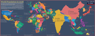
A cartogram is a thematic map of a set of features, in which their geographic size is altered to be directly proportional to a selected ratio-level variable, such as travel time, population, or GNP. Geographic space itself is thus warped, sometimes extremely, in order to visualize the distribution of the variable. It is one of the most abstract types of map; in fact, some forms may more properly be called diagrams. They are primarily used to display emphasis and for analysis as nomographs.
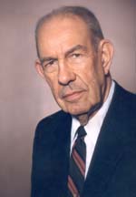
Arthur H. Robinson was an American geographer and cartographer, who was professor in the Geography Department at the University of Wisconsin–Madison from 1947 until he retired in 1980. He was a prolific writer and influential philosopher on cartography, and one of his most notable accomplishments is the Robinson projection of 1961.

Adolf Stieler was a German cartographer and lawyer who worked most of his life in the Justus Perthes Geographical Institute in Gotha. Although he studied law and would serve in government for his entire career, he maintained an interest in cartography and published many famous works. His Handatlas was the leading German world atlas until the middle of the 20th century.

John Bartholomew was a Scottish cartographer.

A thematic map is a type of map that portrays the geographic pattern of a particular subject matter (theme) in a geographic area. This usually involves the use of map symbols to visualize selected properties of geographic features that are not naturally visible, such as temperature, language, or population. In this, they contrast with general reference maps, which focus on the location of a diverse set of physical features, such as rivers, roads, and buildings. Alternative names have been suggested for this class, such as special-subject or special-purpose maps, statistical maps, or distribution maps, but these have generally fallen out of common usage. Thematic mapping is closely allied with the field of Geovisualization.
The history of cartography refers to the development and consequences of cartography, or mapmaking technology, throughout human history. Maps have been one of the most important human inventions for millennia, allowing humans to explain and navigate their way through the world.
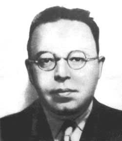
Alexander Radó, also: Alex, Alexander Radolfi, Sándor Kálmán Reich or Alexander Rado, was a Hungarian cartographer who later became a Soviet military intelligence-agent in World War II. Radó was also a member of the resistance to Nazi Germany, devoted to the service of the so-called Red Orchestra, the Soviet espionage and spy network in Western Europe between 1933 and 1945. Within the Red Orchestra he headed the Switzerland-based Red Three group, one of the most efficient components of the Soviet intelligence network.

Terrain cartography or relief mapping is the depiction of the shape of the surface of the Earth on a map, using one or more of several techniques that have been developed. Terrain or relief is an essential aspect of physical geography, and as such its portrayal presents a central problem in cartographic design, and more recently geographic information systems and geovisualization.
Physiographic regions are a means of defining Earth's landforms into distinct regions, based upon the classic three-tiered approach by Nevin M. Fenneman in 1916, that separates landforms into physiographic divisions, physiographic provinces, and physiographic sections. Originally used in North America, the model became the basis for similar classifications of other continents, and was still considered valid as of 1951.
Borden D. Dent (1938–2000) was an American geographer and cartographer who served as professor emeritus and chairman of the Department of Geography and Anthropology at Georgia State University. His textbook, Cartography: Thematic Map Design, is one of the seminal texts in the field, and its sixth edition was reissued in 2009.

Blasius Kozenn was a Slovenian geographer and cartographer. He has occasionally been misidentified as Slovak.
Armin Kohl Lobeck (1886-1958) was a noted American Cartographer, Geomorphologist and Landscape Artist. He was born in New York City on August 16, 1886, but his family moved to Haworth, New Jersey, three years later.

The armadillo projection is a map projection used for world maps. It is neither conformal nor equal-area but instead affords a view evoking a perspective projection while showing most of the globe instead of the half or less that a perspective would. The projection was presented in 1943 by Erwin Raisz (1893–1968) as part of a series of "orthoapsidal" projections, which are perspectives of the globe projected onto various surfaces. This meter of the series has the globe projected onto half a torus. Raisz singled it out and named it the "armadillo" projection.

A Chorochromatic map, also known as an area-class, qualitative area, or mosaic map, is a type of thematic map that portray regions of categorical or nominal data using variations in color symbols. Chorochromatic maps are typically used to represent discrete fields, also known as categorical coverages. Chorochromatic maps differ from choropleth maps in that chorochromatic maps are mapped according to data-driven boundaries instead of trying to make the data fit within existing, sometimes arbitrary units such as political boundaries.

Cartographic design or map design is the process of crafting the appearance of a map, applying the principles of design and knowledge of how maps are used to create a map that has both aesthetic appeal and practical function. It shares this dual goal with almost all forms of design; it also shares with other design, especially graphic design, the three skill sets of artistic talent, scientific reasoning, and technology. As a discipline, it integrates design, geography, and geographic information science.


