
The River Nith is a river in south-west Scotland. The Nith rises in the Carsphairn hills of East Ayrshire, more precisely between Prickeny Hill and Enoch Hill, 4.4 miles (7.1 km) east of Dalmellington. For the majority of its course it flows in a south-easterly direction through Dumfries and Galloway and then into the Solway Firth at Airds Point.

The Feather River is the principal tributary of the Sacramento River, in the Sacramento Valley of Northern California. The river's main stem is about 73 miles (117 km) long. Its length to its most distant headwater tributary is just over 210 miles (340 km). The main stem Feather River begins in Lake Oroville, where its four long tributary forks join—the South Fork, Middle Fork, North Fork, and West Branch Feather Rivers. These and other tributaries drain part of the northern Sierra Nevada, and the extreme southern Cascades, as well as a small portion of the Sacramento Valley. The total drainage basin is about 6,200 square miles (16,000 km2), with approximately 3,604 square miles (9,330 km2) above Lake Oroville.

This is a list of the extreme points of North America: the points that are highest and lowest, and farther north, south, east or west than any other location on the continent. Some of these points are debatable, given the varying definitions of North America.

Calderbank is a village outside the town of Airdrie, North Lanarkshire, Scotland. It lies west of the M73, on the west bank of the North Calder Water. The village lies 13 miles (21 km) east of Glasgow city centre and around 34 miles (55 km) west of Edinburgh. Other nearby towns include: Airdrie, Coatbridge, Bellshill and Motherwell. It has a population of about 1,560 (mid-2020 est.)
The Piscataquis River is a major tributary of the Penobscot River, found in Piscataquis County, Maine, United States. It starts from the confluence of its East Branch and West Branch in Blanchard. The river flows in a mostly eastern direction until it meets the Penobscot at Howland. It is approximately 65 miles (105 km) in length.
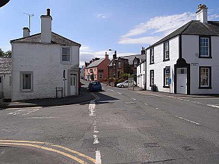
Penpont is a village about 2 miles (3 km) west of Thornhill in Dumfriesshire, in the Dumfries and Galloway region of Scotland. It is near the confluence of the Shinnel Water and Scaur Water rivers in the foothills of the Southern Uplands. It has a population of about 400 people.

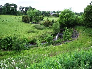
Scaur Water is a river which rises near Polskeoch in the Scaur hills in the region of Dumfries and Galloway, Scotland.

The Mianus River is a 20.3-mile-long (32.7 km) river in Westchester County, New York, and Fairfield County, Connecticut, in the United States. It begins in the town of North Castle, New York in a series of ponds at about 600 feet (180 m) altitude. Flowing northeast into the town of Bedford, it abruptly turns south and passes through the Mianus River Gorge, a nature preserve, before entering Stamford, Connecticut, where it is dammed into the Mianus Reservoir, officially known as the Samuel J. Bargh Reservoir of the Greenwich Water Company. From there, it flows south through Stamford and Greenwich into Long Island Sound, at sea level.
The River Hodder is in Lancashire, England. It is a County Biological Heritage Site.

The River Afton is a small river in Ayrshire, Scotland, which flows north from Alwhat Hill in the Carsphairn and Scaur Hills, through Afton Reservoir and then for eight miles down Glen Afton before joining the River Nith at New Cumnock.
The North Calder Water is a river in North Lanarkshire, Scotland. It flows for 12 miles (19 km) from the Black Loch via the Hillend Reservoir, Caldercruix, Plains, Airdrie, Calderbank, Carnbroe and Viewpark to the River Clyde at Daldowie, south-east of Glasgow. For the last 2 miles (3.2 km) of its course, it forms part of the boundary between North Lanarkshire and Glasgow. The name Calder is thought to be Brythonic and to mean 'hard cold flowing' water.

The River Lew can refer to either of two short rivers that lie close to each other in Devon, England.

The Bungay River is a short river in southeastern Massachusetts that is a tributary of the Ten Mile River.

Urr Water or River Urr is a river in which flows through the counties of Dumfriesshire and Kirkcudbrightshire in southwest Scotland.
German submarine U-217 was a Type VIID mine-laying U-boat of Nazi Germany's Kriegsmarine during World War II.

The Moorfoot Hills are a range of hills south of Edinburgh in east central Scotland, one of the ranges which collectively form the Southern Uplands.
The Croker River is a waterway above the Arctic Circle on the mainland of Northern Canada in the western Kitikmeot Region, Nunavut. It is the largest river between Darnley Bay and Coronation Gulf that flows into Amundsen Gulf. The Croker averages 55 metres (180 ft) in width.

Wetherby Ings are water meadows, by the River Wharfe now used as parkland in Wetherby, West Yorkshire, England. The ings on the north and south bank are used as parkland and for sports grounds for the town's football and rugby league teams. The area is liable to flooding during heavy rain and the river has broken its banks frequently.

The Carsphairn and Scaur Hills are the western and eastern hills respectively of a hill range in the Southern Uplands of Scotland. Ordnance Survey maps don't have a general name for the hill area as a whole. Also, Ordnance Survey use "Scar" rather than the local spelling of "Scaur" - the word is pronounced as "Scar" however. In their Landranger Series of maps, it requires four separate sheets to cover the area.
