The Lagafater Estate

Last updated

The Lagafater Estate
Coordinates: 55°02′39″N4°54′53″W / 55.044051°N 4.914675°W / 55.044051; -4.914675
Website www.lagafater.co.uk

Lagafater is a 7000-acre (2832.8 ha) former sporting estate near New Luce in Dumfries and Galloway, Scotland. Since 1910 it has been in the family of its present owner, Sir Nicholas Spicer, Bt.

Contents

History

Originally in the hands of the Earl of Cassillis, lands including Lagafater were gifted to Thomas Kennedy of Bargany in 1541 and 1550. The estate remained in the wider Kennedy family before being sold in 1822 to the Trustees of John, Earl of Stair. From there, it was sold to Robert Stewart of Corfin in 1847, to Sir George de la Poer Beresford in 1859, to the noted solicitor William White Millar SSC in 1863 and finally to the British Linen Company in 1887.

In 1894, White Millar re-purchased the Estate, and united it with the Dalnigap Estate which he had previously purchased in 1892. White Millar was subsequently imprisoned for embezzlement, and the estate was sold in 1910 to Cedric Randall Boult, father of the internationally noted conductor, Sir Adrian Boult. [1] Sir Adrian's musical commitments were such that he could not visit often, and the estate was inherited by his sister, Olive I E Boult, before passing to her step-great-nephew, Sir Nicholas Spicer Bt.

The Houses

The principal dwelling is Lagafater Lodge, a large Edwardian hunting lodge [2] that was built by Robert Stewart esq. in 1846 as a 'house for the accommodation of Sports Men'. [3] The estate crofts and cottages have comprised Lagafater Cottage, Strabracken (ruined), Barnvannoch and Shennas (now sold). Dalnigap House, originally the principal dwelling for the Dalnigap Estate, is now also in private hands.

The earliest habitations, however, are evidenced by the ancient Hut Circles that lie 800m south of Lagafater Lodge. These were recognized by the Royal Commission on the Ancient and Historical Monuments of Scotland (RCAHMS) in 1981. [4]

The Estate

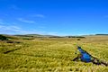
Originally a large heather moorland, the best preserved areas can be found in the Black Glen, to the north of the estate. The high point, Beneraird (439m) affords a view over four kingdoms (England, Scotland, Man, and Northern Ireland). [5] In addition, there are several large coniferous plantations throughout the estate.

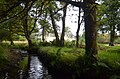
Alongside the Main Water of Luce, a category 3 Salmon River, the estate is home to many burns: Laggie, Scraby Lane, Lagganbeastie, Drummanmoan Loan, Pinwherran and the Loan of Turchloy. [6] There are a number of dramatic falls, notably at Whisky and Dungeon Glens and at Loups of Dalnigap.

A large part of the estate falls within the Glenapp and Galloway Moors Site of Special Scientific Interest (SSSI). [7]

Related Research Articles

<span class="mw-page-title-main">Balmoral Castle</span> Royal residence in Aberdeenshire, Scotland

Balmoral Castle is a large estate house in Aberdeenshire, Scotland, and a residence of the British royal family. It is near the village of Crathie, 9 miles (14 km) west of Ballater and 50 miles (80 km) west of Aberdeen.

<span class="mw-page-title-main">Fairlie, North Ayrshire</span> Human settlement in Scotland

Fairlie is a village in North Ayrshire, Scotland.

<span class="mw-page-title-main">Glen Affric</span> Valley in northern Scotland

Glen Affric is a glen south-west of the village of Cannich in the Highland region of Scotland, some 15 miles west of Loch Ness. The River Affric runs along its length, passing through Loch Affric and Loch Beinn a' Mheadhoin. A minor public road reaches as far as the end of Loch Beinn a' Mheadhoin, but beyond that point only rough tracks and footpaths continue along the glen.

<span class="mw-page-title-main">Water of Luce</span>

The Water of Luce is a river in Dumfries and Galloway, in south west Scotland.

<span class="mw-page-title-main">New Luce</span> Civil parish in south-west Scotland

New Luce is a civil parish in Dumfries and Galloway, south-west Scotland. It lies in the traditional county of Wigtownshire, and is about 10 miles (16 km) in length and 5 miles (8.0 km) in breath, being the upper part of the original Glenluce Parish. New Luce is shown as a civil parish on John Ainslie's county map of 1782.

Perceton is a medieval settlement and old country estate in North Ayrshire, Scotland, near the town of Irvine. The ruined church in Perceton is one of the oldest buildings in the Irvine district. The earliest legible gravestone dates from 1698, though older stone coffins will certainly still rest deep within the small hillock on which the chapel and graveyard sit.

<span class="mw-page-title-main">Dunlop, East Ayrshire</span> Human settlement in Scotland

Dunlop is a village and parish in East Ayrshire, Scotland. It lies on the A735, north-east of Stewarton, seven miles from Kilmarnock. The road runs on to Lugton and the B706 enters the village from Beith and Burnhouse.

<span class="mw-page-title-main">Eglinton Castle</span> Gothic castellated mansion in Kilwinning, Scotland

Eglinton Castle was a large Gothic castellated mansion in Kilwinning, North Ayrshire, Scotland.

<span class="mw-page-title-main">Montgreenan</span>

Montgreenan is an estate in North Ayrshire, Parish of Kilwinning, Scotland. The Lugton Water runs through the policies and farmland of Montgreenan. Nearby are the hamlets of Torranyard and Auchentiber.

<span class="mw-page-title-main">Kennox House</span> House in North Ayrshire, Scotland

Kennox House is situated on Kilwinning Road between Stewarton to Torranyard in North Ayrshire, Parish of Dunlop, Scotland. The house overlooks the Glazert Burn, which runs into the Annick Water at Watermeetings.

<span class="mw-page-title-main">Martnaham Loch</span> Freshwater loch in South Ayrshire, Scotland

Martnaham Loch is a freshwater loch lying across the border between East and South Ayrshire Council Areas, two kilometres from Coylton, in the parishes of Coylton and Dalrymple, three miles from Ayr. The loch lies along an axis from northeast to southwest. The remains of a castle lie on a possibly artificial islet within the loch. The Campbells of Loudoun once held the lands, followed by the Kennedys of Cassillis.

Old Luce is a civil parish in Dumfries and Galloway, Scotland. It lies in the Machars peninsula, in the traditional county of Wigtownshire. The parish is around 10 miles (16 km) long and 8 miles (13 km) broad, and contains 40,350 acres (16,330 ha).

<span class="mw-page-title-main">Shewalton House and estate</span> Human settlement in Scotland

Shewalton House and estate were composed of the 'Lands of Shewalton' and the laird's dwelling, originally a tower castle and later a mansion house on the River Irvine in the Shewalton area, two miles from Irvine and west of Drybridge village, East Ayrshire, Dundonald Parish, Scotland. In 1883 the Boyle's estate of Shewalton was 2,358 acres in extent in Ayrshire and was worth at that time £2,708 a year.

Swindridgemuir House and estate were composed of the 'Lands of Swindridgemuir' and the dwelling house about two miles north-east of Dalry in the old Barony of Kersland, about a mile and a half north of the Blair Estate, North Ayrshire, Scotland. The spelling on the family memorials at Ayr Auld Kirk is 'Swindrigemuir'.

<span class="mw-page-title-main">Ardverikie House</span> Historic site

Ardverikie House is a 19th-century Scottish baronial house in Kinloch Laggan, Newtonmore, Inverness-shire, Scottish Highlands. The house was made famous as the fictional Glenbogle estate in the BBC series Monarch of the Glen.

<span class="mw-page-title-main">Tiroran</span> Human settlement in Scotland

Tiroran is hamlet on the Isle of Mull in Argyll and Bute, Scotland.

<span class="mw-page-title-main">Glen Tanar</span> Glen of the Water of Tanar and national nature reserve in northeast Scotland

Glen Tanar is a glen in Aberdeenshire, eastern Scotland, through which the Water of Tanar flows. Near the mouth of the glen, at Tower o' Ess, the Water of Tanar flows into the River Dee. This flows through Deeside into the North Sea at Aberdeen. Glen Tanar contains the third largest area of Caledonian Forest in Scotland, and is of national and European importance. It is around 18 miles East from the King's private residence at Balmoral Castle.

<span class="mw-page-title-main">Lendalfoot</span> Human settlement in Scotland

Lendalfoot is a small village located on Carleton Bay, parish of Colmonell in the old district of Carrick, now South Ayrshire, about six miles south of Girvan, Scotland. This is mainly a farming district, lacking in woodland, with a low population density. The village sits astride the A77 that runs north to Girvan and south to Cairnryan and Stranraer. Carleton Hill rises to 520 feet or 158 metres from the road and is the site near its summit of earth banks, an ancient fort.

<span class="mw-page-title-main">Carleton Castle</span> Castle in South Ayrshire, Scotland

The ruins of the five storey high 15th century Carleton Castle lie in a prominent position above the village of Lendalfoot located on Carleton Bay, parish of Colmonell in the old district of Carrick, now South Ayrshire, about 6 miles south of Girvan, Scotland.

<span class="mw-page-title-main">Minishant</span> Human settlement in Scotland

Minishant is a village bordering the A77 in the old county of Carrick, South Ayrshire, Scotland. It is located in Maybole Parish, 3+12 miles from Maybole and standing close to the River Doon. The village was originally named Culroy after the Culroy Burn that runs through it.

References

  1. "Los Angeles Herald, Volume 37, Number 56, 26 November 1909". California Digital Newspaper Collection. Center for Bibliographic Studies and Research, University of California, Riverside. Retrieved 9 September 2016.
  2. "Lagafater". Large Holiday Houses. LHH Limited. Retrieved 9 September 2016.
  3. Ordinance Survey (1857). Ayrshire OS Name Books, 1855-1857. Vol. Ayrshire volume 06, part 1. Ordinance Survey. p. 93. Retrieved 3 August 2023.{{cite book}}: CS1 maint: date and year (link)
  4. "Lagafater Lodge". Canmore. Historic Environment Scotland. Retrieved 9 September 2016.
  5. "Beneraird". Hill Bagging. Retrieved 9 September 2016.
  6. "Luce District Salmon Fishery Board". Galloway Fisheries Trust. Retrieved 9 September 2016.
  7. "SSSI : Consolidated list of Sites notified under the Wildlife and Countryside Act 1981 as at 31 March 2002" (PDF). Scottish Natural Heritage. Retrieved 9 September 2016.