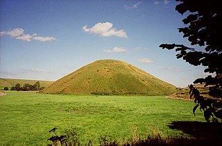
Day House Lane Stone Circle

Last updated

Day House Lane Stone Circle
Stone circle, Day House Lane, Swindon - geograph.org.uk - 432582.jpg
The five stones of the Day House Lane Stone Circle
Wiltshire UK location map.svg
Archaeological site icon (red).svg
Shown within Wiltshire
Alternative nameCoate Stone Circle
LocationNear Coate
Coordinates 51°32′24″N1°44′20″W / 51.540°N 1.739°W / 51.540; -1.739
Type Stone circle
History
Periods Neolithic / Bronze Age

Day House Lane Stone Circle, also known as Coate Stone Circle, is a stone circle near the hamlet of Coate, now on the southeastern edge of Swindon, in the English county of Wiltshire. The ring was part of a tradition of stone circle construction that spread throughout much of Britain, Ireland, and Brittany during the Late Neolithic and Early Bronze Age, over a period between 3300 and 900 BCE. The purpose of such monuments is unknown, although some archaeologists speculate that the stones represented supernatural entities for the circle's builders.

Contents

Five partly buried stones remain at the site. A circle of sarsen megaliths, Day House Lane Stone Circle probably had an original diameter of about 69 metres and possibly contained over thirty stones. It was one of at least seven stone circles that are known to have been erected in the area south of Swindon in northern Wiltshire. The earliest known reference to the site was made by the local writer Richard Jefferies in the 1860s. When the antiquarian A. D. Passmore investigated the site during the 1890s he found nine stones, mostly buried. He observed a line of five stones not far from the circle's northern end, suggesting that these were part of a prehistoric avenue connected to the circle; these too no longer existed by the 21st century.

Location

The stone circle is located immediately to the northeast of Day House Farm, [1] at the front of the building. [2] The land on which it is situated is a flat clay plain at the foot of the chalk escarpment. [1] It would have been intervisible with several other prehistoric monuments located on the Ridgeway. [1]

The circle is about a quarter of a mile from the former village of Coate and two miles southeast from the centre of the town of Swindon. [3] The site is about 9 miles (14 km) northeast of Avebury stone circle. [4] The circle is a Scheduled Ancient Monument under the Ancient Monuments and Archaeological Areas Act 1979. [1]

Context

While the transition from the Early Neolithic to the Late Neolithic in the fourth and third millennia BCE saw much economic and technological continuity, there was a considerable change in the style of monuments erected, particularly in what is now southern and eastern England. [5] By 3000 BCE, the long barrows, causewayed enclosures, and cursuses which had predominated in the Early Neolithic were no longer built, and had been replaced by circular monuments of various kinds. [5] These include earthen henges, timber circles, and stone circles. [6] Stone circles are found in most areas of Britain where stone is available, with the exception of the island's south-eastern corner. [7] They are most densely concentrated in south-western Britain and on the north-eastern horn of Scotland, near Aberdeen. [7] The tradition of their construction may have lasted for 2,400 years, from 3300 to 900 BCE, with the major phase of building taking place between 3000 and 1,300 BCE. [8]

Sheep grazing around some of the stones in the Day House Lane Circle Stone circle, Day House Lane, Swindon, Wiltshire - geograph.org.uk - 252504.jpg
Sheep grazing around some of the stones in the Day House Lane Circle

These stone circles typically show very little evidence of human visitation during the period immediately following their creation. [9] For this reason the historian Ronald Hutton suggested that the circles were not used for rituals that left archaeologically visible evidence, but may have been deliberately left as "silent and empty monuments". [10] The archaeologist Mike Parker Pearson argues that in Neolithic Britain, stone was associated with the dead, and wood with the living. [11] Other archaeologists have proposed that the stone might not represent ancestors, but rather other supernatural entities, such as deities. [10]

In the area of modern Wiltshire, various stone circles were erected, the best known of which are Avebury and Stonehenge. All of the other examples are ruined, and in some cases have been destroyed. [12] As noted by the archaeologist Aubrey Burl, these examples have left behind "only frustrating descriptions and vague positions". [12] Most of the known Wiltshire examples were erected on low-lying positions in the landscape. [12] In the area south of Swindon, a town in northern Wiltshire, at least seven stone circles are reported as having existed, often only a few miles distant from one another; [13] the Day House Lane Stone Circle is for instance 2 km north-east of the (now destroyed) Fir Clump Stone Circle. [14] Although the vestiges of the Day House Lane Stone Circle survive, all of the other known northern Wiltshire circles have been destroyed. [13]

Description

Diagram of the Day House Lane Stone Circle as recorded in 1980 Day House Lane Circle Diagram.png
Diagram of the Day House Lane Stone Circle as recorded in 1980

Based on his observations in the 1890s, the antiquarian A. D. Passmore estimated that the circle had originally been up to 69 metres (225 ft) in diameter. [16] He also thought that it would have been of a slightly irregular shape, with its diameter varying at different points. [17] Based on the surviving stones and their spacing, Passmore suggested that the circle would have once contained over thirty stones. [18] The surviving stones used were sarsen. [19] In the 1890s, Passmore recorded nine stones surviving as part of the circle, but by the early 21st century there were only five. [20] Passmore's investigation found that some of the stones were up to 3.0 metres (10 ft) in length. [16]

It is possible that there were stone rows or avenues connecting to the circle. [16] In the 1890s, Passmore recorded a line of five stones leading towards the north of the circle, which might have represented such an avenue, although by the 21st century these stones were also gone. [20] In March 2009, work overseen by the Highways Agency revealed two large sarsen boulders opposite Day House Farm. [21]

Commenting on the state of the circle in 1980, the archaeologist Aubrey Burl stated that the circle was "almost completely overgrown", [16] an assessment he repeated in 2000. [4] The Historic England listing for the site nevertheless considered it to be a "comparatively well preserved example of its class". [1]

Antiquarian and archaeological research

The earliest known antiquarian observation of Day House Lane Stone Circle came from about 1867 when the naturalist and writer Richard Jefferies described coming across it. [16] [22] He was familiar with the area, and his wife had spent some of her early years living at Day House Farm. [23] His comments on the circle would be published posthumously in the 1896 book Jefferies' Land: A History of Swindon and Its Environs. [24]

Jeffries related that he had found "five Sarsden [sic] stones much sunk into the ground, but forming a semi-circle of which the lane is the base-line or tangent. There was a sixth upon the edge of the lane, but it was blown up and removed, in order to make the road more serviceable, a few years ago." [25] He suggested that it looked like a "Druidical" circle and might have been made by the druids, but noted that whether this was the case or not "cannot now be determined". [26] Jefferies also observed that in an adjacent field, which was known as the Plain, could be found three more sarsens, one of which was much larger than the others. [26]

A. D. Passmore's investigation

The Day House Farm, in front of which the circle is located Day House Farmhouse, Day House Lane, Swindon - geograph.org.uk - 252490.jpg
The Day House Farm, in front of which the circle is located

The antiquarian A. D. Passmore outlined his investigation of the stone circle in an 1894 article for the Wiltshire Archaeological and Natural History Magazine . As part of this he thanked W. Handy, the tenant of Day House Farm, for "the kind way in which he has allowed me to explore his fields". [27] In his private notebooks he related that he first discovered them in January 1893. [19] Passmore related that at that time all of the stones in the circle were prostrate and largely buried beneath the ground. They were, he noted, "not at all conspicuous", with none protruding for more than 18 inches above the turf and some barely visible. [2]

Passmore probed the ground with an iron bar to ascertain the location and dimensions of various stones in the circle. [18] He also dug into the space between those stones he numbered four and five, discovering a piece of burnt sarsen and patch of white ash beneath the ground, evidence for the burning and cracking of sarsen on the site. [18] He observed that the western part of the circle was largely occupied by cow yards and rick yards and suggested that most of the stones in this area had been broken up or removed. [18] He commented on the presence of some "big fragments" of sarsen lying around the vicinity and an area of sarsen paving, suggesting that these stones had once been part of the circle before being removed and repurposed. [18]

Passmore noted that in a field to the southwest of the farmhouse stood three large sarsen boulders. [28] One, which was lying on its side, measured at least 0.91 metres (3 ft) and 2.1 metres (7 ft) long. The other two were smaller. [29] Passmore related that an old man had recollected seeing other stones in this field being broken up many decades previously. The old man thought that there had once been a full circle of stones in the field, although Passmore considered this testimony "not sufficiently strong to build upon". [29] Passmore also related finding flint tools and crude pieces of pottery in the field near these sarsens. [29]

Passmore also observed a third feature in the vicinity. This was a row of five stones beside the road in front of the farm; one was on the eastern side of the road, the other four being on the western side or in an adjacent ditch. [29] He noted that several of these stones were "of considerable size". [29] Passmore suggested that this may have once formed a prehistoric avenue which could have extended to meet the northern side of the Day House Lane Stone Circle. [29] Passmore rejected the idea that these stones had never formed a deliberate row and had simply been moved to the side of the road by farmers eager to get them out of their fields. If that were the case, he reasoned, there would not be such even spacing between the third and fourth, and then the fourth and fifth, of these stones. He also suggested that if farmers wished to remove the stones from their fields, they would break them up into smaller fragments rather than going to the effort of moving them whole. [29]

Cultural heritage

In the late 2000s, the Swindon Gateway Partnership put forward proposals to build 1,800 homes and a university campus near Coate Water. Local residents raised concerns that this development would harm the archaeology of the area and damage any opportunity to use it to encourage tourism. The Swindon Advertiser quoted Jean Saunders of the Jefferies Land Conservation Trust as saying that with sites like the Day House Farm Stone Circle, two round barrows, and a Bronze Age settlement in the area, Coate could "create almost a mini-Avebury" but that that possibility would be quashed if development went ahead. [21] Campaigners opposed to the residential development asked the government to designate the impacted locale as a conservation area to protect its heritage. [30] The anti-development campaign failed and after the authorities gave their backing to the construction project, the Swindon Civic Voice group organised a two-day event in April 2014 to celebrate Coate's heritage and encourage people to view the Day House Farm Stone Circle and other historic sites before the landscape was significantly altered. [31]

Related Research Articles

<span class="mw-page-title-main">Ring of Brodgar</span> A neolithic stone circle in Orkney, Scotland

The Ring of Brodgar is a Neolithic henge and stone circle about 6 miles north-east of Stromness on Mainland, the largest island in Orkney, Scotland. It is part of the UNESCO World Heritage Site known as the Heart of Neolithic Orkney.

<span class="mw-page-title-main">Avebury</span> Neolithic henge monument in Wiltshire, England

Avebury is a Neolithic henge monument containing three stone circles, around the village of Avebury in Wiltshire, in southwest England. One of the best known prehistoric sites in Britain, it contains the largest megalithic stone circle in the world. It is both a tourist attraction and a place of religious importance to contemporary pagans.

<span class="mw-page-title-main">West Kennet Long Barrow</span> Neolithic tomb or barrow in Wiltshire, England

The West Kennet Long Barrow, also known as South Long Barrow, is a chambered long barrow near the village of Avebury in the south-western English county of Wiltshire. Probably constructed in the thirty-seventh century BC, during Britain's Early Neolithic period, today it survives in a partially reconstructed state.

<span class="mw-page-title-main">The Sanctuary</span> Prehistoric site in Wiltshire, England

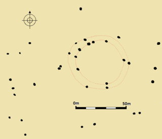
The Sanctuary was a stone and timber circle near the village of Avebury in the south-western English county of Wiltshire. Excavation has revealed the location of the 58 stone sockets and 62 post-holes. The ring was part of a tradition of stone circle construction that spread throughout much of Britain, Ireland, and Brittany during the Late Neolithic and Early Bronze Age, over a period between 3300 and 900 BCE. The purpose of such monuments is unknown, although archaeologists speculate that the stones represented supernatural entities for the circle's builders.

<span class="mw-page-title-main">Medway Megaliths</span> Group of long barrows in Kent, England

The Medway Megaliths, sometimes termed the Kentish Megaliths, are a group of Early Neolithic chambered long barrows and other megalithic monuments located in the lower valley of the River Medway in Kent, South-East England. Constructed from local sarsen stone and soil between the 4th and 3rd millennia BCE, they represent the only known prehistoric megalithic group in eastern England and the most south-easterly group in Britain.

<span class="mw-page-title-main">Addington Long Barrow</span> Chambered long barrow in Kent, England

Addington Long Barrow is a chambered long barrow located near the village of Addington in the southeastern English county of Kent. Probably constructed in the fourth millennium BCE, during Britain's Early Neolithic period, today it survives only in a ruined state. Built of earth and about fifty local sarsen megaliths, the long barrow consisted of a sub-rectangular earthen tumulus enclosed by kerb-stones. Collapsed stones on the northeastern end of the chamber probably once formed a stone chamber in which human remains might have been deposited, though none have been discovered.

<span class="mw-page-title-main">Coate Water Country Park</span>

Coate Water is a country park situated 5 km (3.1 mi) to the southeast of central Swindon, England, near junction 15 of the M4. It takes its name from its main feature, a reservoir originally built to provide water for the Wilts & Berks Canal. Now named 'Coate Water Country Park', the lake and its surroundings are both a leisure facility and a nature reserve.

<span class="mw-page-title-main">Hoarstones</span> Stone circle in Shropshire, England

The Hoarstones, or Hoar Stone Circle, is a stone circle in the civil parish of Chirbury with Brompton in the English county of Shropshire. The Hoarstones are part of a tradition of stone circle construction that spread throughout much of Britain, Ireland, and Brittany during the Late Neolithic and Early Bronze Ages, over a period between 3300 and 900 BCE. The purpose of such monuments is unknown.

<span class="mw-page-title-main">Stone circles in the British Isles and Brittany</span> Megalithic tradition of monuments

The stone circles in the British Isles and Brittany are a megalithic tradition of monuments consisting of standing stones arranged in rings. These were constructed from 3300 to 900 BCE in Britain, Ireland and Brittany. It has been estimated that around 4,000 of these monuments were originally constructed in this part of north-western Europe during this period. Around 1,300 of them are recorded, the others having been destroyed.

<span class="mw-page-title-main">Nine Stones Close</span> Stone circle in Derbyshire, England

Nine Stones Close, also known as the Grey Ladies, is a stone circle on Harthill Moor in Derbyshire in the English East Midlands. It is part of a tradition of stone circle construction that spread throughout much of Britain, Ireland, and Brittany during the Late Neolithic and Early Bronze Ages, over a period between 3300 and 900 BCE. The purpose of the monument is unknown.

<span class="mw-page-title-main">Nine Stones, Winterbourne Abbas</span> Stone circle in Dorset, England

The Nine Stones, also known as the Devil's Nine Stones, the Nine Ladies, or Lady Williams and her Dog, is a stone circle located near to the village of Winterbourne Abbas in the southwestern English county of Dorset. Archaeologists believe that it was likely erected during the Bronze Age.

<span class="mw-page-title-main">Kingston Russell Stone Circle</span> Stone circle in Dorset, England

Kingston Russell Stone Circle, also known as the Gorwell Circle, is a stone circle located between the villages of Abbotsbury and Littlebredy in the south-western English county of Dorset. Archaeologists believe that it was likely erected during the Bronze Age. The Kingston Russell ring is part of a tradition of stone circle construction that spread throughout much of Britain, Ireland, and Brittany during the Late Neolithic and Early Bronze Age, over a period between 3,300 and 900 BCE. The purpose of such monuments is unknown, although archaeologists speculate that they were likely religious sites, with the stones perhaps having supernatural associations for those who built the circles.

<span class="mw-page-title-main">Hampton Down Stone Circle</span> Bronze Age construction in Dorset, England

The Hampton Down Stone Circle is a stone circle located near to the village of Portesham in the south-western English county of Dorset. Archaeologists believe that it was likely erected during the Bronze Age. The Hampton Down ring is part of a tradition of stone circle construction that spread throughout much of Britain, Ireland, and Brittany during the Late Neolithic and Early Bronze Age, over a period between 3,300 and 900 BCE. The purpose of such monuments is unknown, although archaeologists speculate that they were likely religious sites, with the stones perhaps having supernatural associations for those who built the circles. However, it has been suggested that the site is not a stone circle at all, but is instead made up of kerbstones from a Bronze Age round barrow.

<span class="mw-page-title-main">Falkner's Circle</span> Neolithic stone circle in Wiltshire, England

Falkner's Circle was a stone circle near the village of Avebury in the south-western English county of Wiltshire. Built from twelve sarsen megaliths, it measured about 37 metres (121 ft) in diameter, although only one of these stones remains standing.

<span class="mw-page-title-main">Fir Clump Stone Circle</span> Neolithic stone circle in Wiltshire, England

Fir Clump Stone Circle was a stone circle in Burderop Wood near Wroughton, Wiltshire, in South West England. The ring was part of a tradition of stone circle construction that spread throughout much of Britain, Ireland, and Brittany during the Late Neolithic and Early Bronze Age, over a period between 3300 and 900 BCE. The purpose of such monuments is unknown, although some archaeologists speculate that the stones represented supernatural entities for the circle's builders.

Winterbourne Bassett Stone Circle is the remains of a stone circle near the village of Winterbourne Bassett in Wiltshire, South West England. Investigations in the 18th and 19th centuries found evidence of an outer and inner ring, and a single central stone; today six stones are visible although none remain upright.

Clatford Stone Circle, also known as The Broadstones, was a stone circle located in the village of Clatford in the south-western English county of Wiltshire.

Tisbury Stone Circle and Henge was a stone circle and henge in Tisbury, Wiltshire. Archaeologists believe that it was likely erected during the Bronze Age.

Broome Stone Circle was a stone circle located in the south-western English county of Wiltshire. The ring was part of a tradition of stone circle construction that spread throughout much of Britain, Ireland, and Brittany during the Late Neolithic and Early Bronze Age, over a period between 3300 and 900 BCE. The purpose of such monuments is unknown, although archaeologists speculate that the stones represented supernatural entities for the circle's builders.

Hodson Stone Circle was a stone circle in the village of Hodson in the south-western English county of Wiltshire. The ring was part of a tradition of stone circle construction that spread throughout much of Britain, Ireland, and Brittany during the Late Neolithic and Early Bronze Age, over a period between 3300 and 900 BCE. The purpose of such monuments is unknown, although some archaeologists speculate that the stones represented supernatural entities for the circle's builders.

References

Footnotes

  1. 1 2 3 4 5 Historic England 2020.
  2. 1 2 Passmore 1894, p. 171.
  3. Passmore 1894, p. 171; Thom, Thom & Burl 1980, p. 135.
  4. 1 2 Burl 2000, p. 311.
  5. 1 2 Hutton 2013, p. 81.
  6. Hutton 2013, pp. 91–94.
  7. 1 2 Hutton 2013, p. 94.
  8. Burl 2000, p. 13.
  9. Hutton 2013, p. 97.
  10. 1 2 Hutton 2013, p. 98.
  11. Hutton 2013, pp. 97–98.
  12. 1 2 3 Burl 2000, p. 310.
  13. 1 2 Burl 2004, p. 197.
  14. Field & McOmish 2017, pp. 78–79.
  15. Thom, Thom & Burl 1980, p. 134.
  16. 1 2 3 4 5 Thom, Thom & Burl 1980, p. 135.
  17. Passmore 1894, p. 172; Thom, Thom & Burl 1980, p. 135.
  18. 1 2 3 4 5 Passmore 1894, p. 172.
  19. 1 2 Burl 2004, p. 201.
  20. 1 2 Field & McOmish 2017, p. 79.
  21. 1 2 Wallin 2009.
  22. Ralph Bernard Pugh; Elizabeth Crittall; D. A. Crowley (1957). Volume 1: Archaeological Gazetteer. Wiltshire Victoria County History. Institute of Historical Research. p. 56. ISBN   978-0-19-722735-0.
  23. Jefferies 1896, p. 134.
  24. Jefferies 1896, pp. 134–135.
  25. Jefferies 1896, pp. 134–135; Thom, Thom & Burl 1980, p. 135.
  26. 1 2 Jefferies 1896, p. 135.
  27. Passmore 1894, p. 174.
  28. Passmore 1894, pp. 172–173.
  29. 1 2 3 4 5 6 7 Passmore 1894, p. 173.
  30. Anon 2005.
  31. Leighton 2014.

Bibliography

Further reading