Description
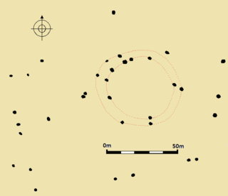
The Twelve Apostles consists of the remains of a stone circle with a diameter of about 15 metres. [5] The circle originally had between 16 and 20 stones, [1] but it is now reduced to 12 stones. [5] The stones are made from the local millstone grit. [1] All of the stones were fallen by the mid-20th-century and were lying loose upon the ground. [3]
The circle was inside a bank 1.2 metres (3 ft 11 in) wide and 0.6 metres (2 ft 0 in) high. [1] The bank was still traceable in the 1920s but has apparently eroded since then due to visitors walking over the ground. [3] At the centre of the circle was a small mound, which may have been the disturbed remains of a burial cairn. [1]
In 1971 a group of amateurs made an unauthorised attempt to re-erect the fallen stones, but the stones soon fell again. [3] The stones have since been re-erected. [6] It is not clear who re-erected them, nor when. [6] The site suffers severe visitor erosion, as it was formerly hidden beneath heather, but is now in an area of bare trampled soil. [3] It is regarded as one of the most damaged prehistoric sites in West Yorkshire. [6]

Ilkley is a spa town and civil parish in the City of Bradford in West Yorkshire, in Northern England. Historically part of the West Riding of Yorkshire, Ilkley civil parish includes the adjacent village of Ben Rhydding and is a ward within the City of Bradford. Approximately 12 miles (19 km) north of Bradford and 17 miles (27 km) north-west of Leeds, the town lies mainly on the south bank of the River Wharfe in Wharfedale, one of the Yorkshire Dales.

Wharfedale is the valley of the upper parts of the River Wharfe and one of the Yorkshire Dales. It is situated in North Yorkshire, and the cities of Leeds and Bradford in West Yorkshire. It is the upper valley of the River Wharfe. Towns and villages in Wharfedale include Buckden, Kettlewell, Conistone, Grassington, Hebden, Bolton Abbey, Addingham, Ilkley, Burley-in-Wharfedale, Otley, Pool-in-Wharfedale, Arthington, Collingham and Wetherby. Beyond Wetherby, the valley opens out and becomes part of the Vale of York.
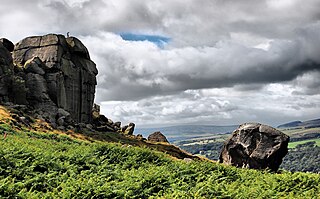
Ilkley Moor is part of Rombalds Moor, the moorland between Ilkley and Keighley in West Yorkshire, England. The moor, which rises to 402 m (1,319 ft) above sea level, is well known as the inspiration for the Yorkshire "county anthem" On Ilkla Moor Baht 'at.

Arbor Low is a well-preserved Neolithic henge in the Derbyshire Peak District, England. It lies on a Carboniferous Limestone plateau known as the White Peak area. The monument consists of a stone circle surrounded by earthworks and a ditch.

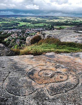
Cup and ring marks or cup marks are a form of prehistoric art found in the Atlantic seaboard of Europe (Ireland, Wales, Northern England, Scotland, France, Portugal, and Spain – and in Mediterranean Europe – Italy, Azerbaijan and Greece, as well as in Scandinavia and in Switzerland.

The Hurlers is a group of three stone circles in the civil parish of St Cleer, Cornwall, England, UK. The site is half-a-mile (0.8 km) west of the village of Minions on the eastern flank of Bodmin Moor, and approximately four miles (6 km) north of Liskeard.
Rombalds Moor is an area of moorland in West Yorkshire, England, between the Airedale and Wharfedale valleys. The towns of Ilkley and Keighley lie to its northern and southern edges, respectively. The moor is sometimes referred to as Ilkley Moor, though technically this refers to the section of moor on the northern flank, above the town of Ilkley.

Doll Tor is a stone circle located just to the west of Stanton Moor, near the village of Birchover, Derbyshire in the English East Midlands. Doll Tor is part of a tradition of stone circle construction that spread throughout much of Britain, Ireland, and Brittany during the Late Neolithic and Early Bronze Ages, over a period between 3300 and 900 BCE. The purpose of such monuments is unknown, although archaeologists speculate that the stones represented supernatural entities for the circles' builders.

Burley Woodhead is a hamlet in the City of Bradford, in West Yorkshire, England. The hamlet is 1 mile (1.6 km) to the south-west of Burley in Wharfedale and is approximately 3 miles (5 km) from the spa town of Ilkley. Burley Woodhead comprises chiefly of a small cluster of farms and homes along the road from Ilkley to Guiseley at the foot of Burley Moor, though the village is at 560 feet (170 m) above sea level, with the moor being some 1,300 feet (400 m) above sea level. The local public house is The Hermit.

Prehistoric Orkney refers only to the prehistory of the Orkney archipelago of Scotland that begins with human occupation. Although some records referring to Orkney survive that were written during the Roman invasions of Scotland, “prehistory” in northern Scotland is defined as lasting until the start of Scotland's Early Historic Period.
Ilkley is a town and civil parish in West Yorkshire, in the north of England. It has been inhabited since at least the Mesolithic period; was the site of a Roman fort, and much later an early example of a spa town. In more recent times it serves as a residential district within the travel to work areas of Bradford, Leeds and Keighley.

Fernacre, also known as Fernacre stone circle or Fernacre circle, is a stone circle located on the slopes of the De Lank River, 1.25 miles (2.01 km) northeast of St Breward on Bodmin Moor in Cornwall in the United Kingdom.

The Shap Stone Avenue is a megalithic complex near Shap in Cumbria, England, comprising stone circles, a two-mile avenue of stones, and burial mounds.

Nine Stones Close, also known as the Grey Ladies, is a stone circle on Harthill Moor in Derbyshire in the English East Midlands. It is part of a tradition of stone circle construction that spread throughout much of Britain, Ireland, and Brittany during the Late Neolithic and Early Bronze Ages, over a period between 3300 and 900 BCE. The purpose of the monument is unknown.

The Grubstones is a stone circle on Burley Moor in West Yorkshire, England. It is believed to be either an embanked stone circle or a ring cairn.
British megalith architecture is the study of those ancient cultures that built megalithic sites on the British Isles, including the research and documentation of these sites. The classification sometimes used of these cultures based on geological criteria is problematic.

A Dales High Way is a long-distance footpath in northern England. It is 90 miles (140 km) long and runs from Saltaire in West Yorkshire to Appleby-in-Westmorland, Cumbria, roughly parallel to the line of the Settle and Carlisle Railway.

Porlock Stone Circle is a stone circle located on Exmoor, near the village of Porlock in the south-western English county of Somerset. The Porlock ring is part of a tradition of stone circle construction that spread throughout much of Britain, Ireland, and Brittany during the Late Neolithic and Early Bronze Age, over a period between 3300 and 900 BCE. The purpose of such monuments is unknown, although archaeologists speculate that the stones represented supernatural entities for the circles' builders.
Fir Clump Stone Circle was a stone circle in Burderop Wood near Wroughton, Wiltshire, in South West England. The ring was part of a tradition of stone circle construction that spread throughout much of Britain, Ireland, and Brittany during the Late Neolithic and Early Bronze Age, over a period between 3300 and 900 BCE. The purpose of such monuments is unknown, although some archaeologists speculate that the stones represented supernatural entities for the circle's builders.

Balbirnie Stone Circle is an archaeological site, a stone circle on the north-eastern edge of Glenrothes, in Fife, Scotland. The site was in use from the late Neolithic period to the late second millennium BC.

