
Stonehenge is a prehistoric monument on Salisbury Plain in Wiltshire, England, two miles (3 km) west of Amesbury. It consists of an outer ring of vertical sarsen standing stones, each around 13 feet (4.0 m) high, seven feet (2.1 m) wide, and weighing around 25 tons, topped by connecting horizontal lintel stones. Inside is a ring of smaller bluestones. Inside these are free-standing trilithons, two bulkier vertical Sarsens joined by one lintel. The whole monument, now ruinous, is orientated towards the sunrise on the summer solstice. The stones are set within earthworks in the middle of the most dense complex of Neolithic and Bronze Age monuments in England, including several hundred tumuli.

Avebury is a Neolithic henge monument containing three stone circles, around the village of Avebury in Wiltshire, in southwest England. One of the best known prehistoric sites in Britain, it contains the largest megalithic stone circle in the world. It is both a tourist attraction and a place of religious importance to contemporary pagans.

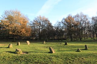
Arbor Low is a well-preserved Neolithic henge in the Derbyshire Peak District, England. It lies on a Carboniferous Limestone plateau known as the White Peak area. The monument consists of a stone circle surrounded by earthworks and a ditch.

A stone circle is a ring of standing stones. Most are found in Northwestern Europe—especially in Britain, Ireland and Brittany—and typically date from the Late Neolithic and Early Bronze Age, with most being built from 3000 BC. The best known examples include those at the henge monument at Avebury, the Rollright Stones, and elements within the ring of standing stones at Stonehenge. There are scattered examples from other parts of Europe. Later, during the Iron Age, stone circles were built in southern Scandinavia.

The Stanton Drew stone circles are just outside the village of Stanton Drew in the English county of Somerset. The largest stone circle is the Great Circle, 113 metres (371 ft) in diameter and the second largest stone circle in Britain ; it is considered to be one of the largest Neolithic monuments to have been built. The date of construction is not known, but is thought to be between 3000 and 2000 BCE, which places it in the Late Neolithic to Early Bronze Age. It was made a scheduled monument in 1982.

Long Meg and Her Daughters is a Neolithic stone circle situated north of Penrith in Cumbria, North West England. One of around 1,300 stone circles in the British Isles and Brittany, it was constructed as a part of a megalithic tradition that emerged during Neolithic, and continued into the Early Bronze Age. The stone circle is the third widest in England, behind Avebury in Wiltshire, and only slightly smaller than Stanton Drew in Somerset.

The stone circle at Castlerigg is situated near Keswick in Cumbria, North West England. One of around 1,300 stone circles in the British Isles and Brittany, it was constructed as a part of a megalithic tradition that lasted from 3,300 to 900 BC, during the Late Neolithic and Early Bronze Ages.

Bardsea is a village in the Low Furness area of Cumbria, England. It is two miles to the south-east of Ulverston on the northern coast of Morecambe Bay. It is in the historic county of Lancashire.
The Nine Ladies is a stone circle located on Stanton Moor in Derbyshire in the English East Midlands. The Nine Ladies is part of a tradition of stone circle construction that spread throughout much of Britain, Ireland, and Brittany during the Late Neolithic and Early Bronze Ages, over a period between 3300 and 900 BCE. The purpose of such monuments is unknown, although archaeologists speculate that the stones represented supernatural entities for the circles' builders.

Muchland is a medieval manor in Low Furness in the county of Cumbria in northern England. The manor was the seat of the Lords of Aldingham, and included at its peak the villages of Bardsea, Urswick, Scales, Stainton, Sunbrick, Baycliff, Gleaston, Aldingham, Dendron, Leece and Newbiggin. The area also features the historic remains of Gleaston Castle, Aldingham Castle, Gleaston Water Mill, the Druids' Temple at Birkrigg, plus many prehistoric remains around Urswick and Scales.
Swinside, which is also known as Sunkenkirk and Swineshead, is a stone circle lying beside Swinside Fell, part of Black Combe in southern Cumbria, North West England. One of around 1,300 recorded stone circles in the British Isles and Brittany, it was constructed as a part of a megalithic tradition that lasted from 3,300 to 900 BC, during what archaeologists categorise as the Late Neolithic and Early Bronze Ages.
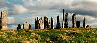
The Callanish Stones are an arrangement of standing stones placed in a cruciform pattern with a central stone circle. They were erected in the late Neolithic era, and were a focus for ritual activity during the Bronze Age. They are near the village of Callanish on the west coast of Lewis in the Outer Hebrides, Scotland.

Mayburgh Henge is a large prehistoric monument in the county of Cumbria in northern England. The henge is in the care of English Heritage and is a Scheduled Ancient Monument. It is 400 metres from King Arthur's Round Table Henge.

Doll Tor is a stone circle located just to the west of Stanton Moor, near the village of Birchover, Derbyshire in the English East Midlands. Doll Tor is part of a tradition of stone circle construction that spread throughout much of Britain, Ireland, and Brittany during the Late Neolithic and Early Bronze Ages, over a period between 3300 and 900 BCE. The purpose of such monuments is unknown, although archaeologists speculate that the stones represented supernatural entities for the circles' builders.

The Bridestones is a chambered cairn, near Congleton, Cheshire, England, that was constructed in the Neolithic period about 3500–2400 BC. It was described in 1764 as being 120 yards (110 m) long and 12 yards (11 m) wide, containing three separate compartments, of which only one remains today. The remaining compartment is 6 metres (20 ft) long by 2.7 metres (8.9 ft) wide, and consists of vertical stone slabs, divided by a now-broken cross slab. The cairn originally had a stone circle surrounding it, with four portal stones; two of these portal stones still remain. The site is protected as a scheduled ancient monument.
Birkrigg or Birkrigg Common is an open-area of limestone countryside near the town of Ulverston on the Furness Peninsula in southern Cumbria, England. There is extensive limestone pavement on Birkrigg, which is protected under The Wildlife and Countryside Act 1981. Birkrigg's peak is at 136 metres (446 ft), but its position as the high point on the east of the Furness Peninsula affords it extensive views to the Lake District, Yorkshire Dales, Howgills and across Morecambe Bay to Blackpool.

Oddendale is a hamlet in Cumbria, England, near the large village of Shap. For transport there is the M6 motorway and the A6 road.

Knipescar Common, or Knipe Scar, is an upland area in the east of the English Lake District, above the River Lowther, near Bampton, Cumbria. It is the subject of a chapter of Wainwright's book The Outlying Fells of Lakeland. The summit is "indefinite" but reaches 1,118 feet (341 m) and there are limestone outcrops and an ancient enclosure. Wainwright commends the views which include Blencathra to the north and "a continuous skyline of the higher Pennines."

The Shap Stone Avenue is a megalithic complex near Shap in Cumbria, England, comprising stone circles, a two-mile avenue of stones, and burial mounds.

Nine Stones Close, also known as the Grey Ladies, is a Bronze Age stone circle located near Youlgreave in Derbyshire. It sits within a local prehistoric landscape that includes Bronze Age barrows and settlement enclosures, and is part of a tradition of stone circle construction that spread throughout much of Britain, Ireland, and Brittany during the Late Neolithic and Early Bronze Ages, over a period between 3300 and 900 BCE. The purpose of the monument is unknown, although archaeologists have speculated that the stones represented supernatural entities.


