The Bull Ring

Last updated

The Bull Ring
BullRingDoveHoles.JPG
Location Dove Holes
Region Derbyshire, England
Coordinates 53°18′2.5″N1°53′3.92″W / 53.300694°N 1.8844222°W / 53.300694; -1.8844222
Type Henge (Class II)
History
Periodslate Neolithic
Site notes
Conditionsome damage
Official nameBull Ring henge, oval barrow and bowl barrow
Designated26 November 1928 [1]
Reference no.1011204

The Bull Ring is a Class II henge that was built in the late Neolithic period near Dove Holes in Derbyshire, England. [1]

Contents

It has coordinates 53°18′03″N1°53′04″W / 53.300695°N 1.884423°W / 53.300695; -1.884423 [2] (grid reference SK 0785 7823 ), and is National Monument number 23282. There are also two barrows about 20m away from the henge; one oval, one bowl. [1]

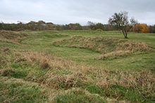
The henge consists of a large, circular earthwork, [3] which is currently about 1 metre (3 ft) high and 9–11 metres (30–36 ft) wide; however it was originally 2 metres (7 ft) high and 5.5–7 metres (18–23 ft) wide. The henge has a ditch on the inside, which varies between 0.5 and 1 metre (1 ft 8 in and 3 ft 3 in) deep and 8 and 12 metres (26 and 39 ft) wide; it was originally 1.2–2 metres (3 ft 11 in – 6 ft 7 in) deep and 5–6.5 metres (16–21 ft) wide. The ditch and bank are separated by a berm, which was originally 5 metres (16 ft) wide. It encloses an area 53 (north–south) by 46 (east–west) metres, with entrances to the north and south, each of which have a causeway across the ditch. A skeleton was reputedly found near the north entrance; this entrance was also damaged in the 19th century by quarrying. The centre of the henge was ploughed in the 18th century; a drystone wall was also built across the site during the same era. [1]

A single standing stone (orthostat) was recorded as remaining in 1789 by Pilkington, potentially the remnant of a stone circle. [1] It has been suggested that stones from the henge were used as sleepers for the Peak Forest Tramway circa 1790. [4]

A minor excavation was carried out in the west ditch in 1902 by Micah Salt; this reputedly discovered some pottery sherds and flint flakes, which have since been lost. [1] A trial excavation by Oxford University Archaeological Society in 1949 established that the ring has two entrances, and also provided information about the original size of the bank and ditch. However, it did not provide any evidence of stones on the site. [5] The excavation also turned up flint flakes, as well as a rim from a pottery food vessel. [1]

A third excavation was carried out in 1984 outside the south entrance, which found further flint flakes and pottery, several pits, and stakeholes of a fence following the henge bank, which are potentially original features of the henge. [1] [6] Most recently, magnetometer and earth resistance surveys were carried out in 2000, with no conclusive results. [7]

The oval barrow to the south-west of the henge is about 27 by 21 metres (89 ft × 69 ft), and is approximately 2.5 metres (8 ft 2 in) high. It was constructed some time in the early to mid-Neolithic period. A later (late Neolithic to late Bronze Age) bowl barrow is superimposed on it. The summit of the oval barrow was disturbed by a World War II slit trench; the edges of the barrow have also been disturbed by ploughing as well as a drystone wall, which has subsequently been removed. The barrow has not been excavated. [1]

See also

Related Research Articles

<span class="mw-page-title-main">Ring of Brodgar</span> A neolithic stone circle in Orkney, Scotland

The Ring of Brodgar is a Neolithic henge and stone circle about 6 miles north-east of Stromness on Mainland, the largest island in Orkney, Scotland. It is part of the UNESCO World Heritage Site known as the Heart of Neolithic Orkney.

<span class="mw-page-title-main">Woodhenge</span> Neolithic henge and timber circle monument near Stonehenge

Woodhenge is a Neolithic Class II henge and timber circle monument within the Stonehenge World Heritage Site in Wiltshire, England. It is 2 miles (3.2 km) northeast of Stonehenge, in Durrington parish, just north of the town of Amesbury.

<span class="mw-page-title-main">Duggleby Howe</span> Large round barrow in England

Duggleby Howe is one of the largest round barrows in Britain, located on the southern side of the Great Wold Valley in the district of Ryedale, and is one of four such monuments in this area, known collectively as the Great barrows of East Yorkshire. Duggleby Howe is believed on the basis of artefacts recovered to be of Late Neolithic date, but no radiocarbon dates are available. Howe as a place name is believed to have originated from the Old Norse word haugr.

<span class="mw-page-title-main">Henge</span> Type of Neolithic earthwork

There are three related types of Neolithic earthwork that are all sometimes loosely called henges. The essential characteristic of all three is that they feature a ring-shaped bank and ditch, with the ditch inside the bank. Because the internal ditches would have served defensive purposes poorly, henges are not considered to have been defensive constructions. The three henge types are as follows, with the figure in brackets being the approximate diameter of the central flat area:

  1. Henge. The word henge refers to a particular type of earthwork of the Neolithic period, typically consisting of a roughly circular or oval-shaped bank with an internal ditch surrounding a central flat area of more than 20 m (66 ft) in diameter. There is typically little if any evidence of occupation in a henge, although they may contain ritual structures such as stone circles, timber circles and coves. Henge monument is sometimes used as a synonym for henge. Henges sometimes, but by no means always, featured stone or timber circles, and circle henge is sometimes used to describe these structures. The three largest stone circles in Britain are each within a henge. Examples of henges without significant internal monuments are the three henges of Thornborough Henges. Although having given its name to the word henge, Stonehenge is atypical in that the ditch is outside the main earthwork bank.
  2. Hengiform monument. Like an ordinary henge, except the central flat area is between 5 and 20 m (16–66 ft) in diameter, they comprise a modest earthwork with a fairly wide outer bank. The terms mini-henge or Dorchester henge are sometimes used as synonyms for hengiform monument. An example is the Neolithic site at Wormy Hillock Henge.
  3. Henge enclosure. A Neolithic ring earthwork with the ditch inside the bank, with the central flat area having abundant evidence of occupation and usually being more than 300 m (980 ft) in diameter. Some true henges are as large as this, but lack evidence of domestic occupation. Super-henge or superhenge is sometimes used as a synonym for a henge enclosure. However, sometimes the term is used to indicate size alone rather than use, e.g. "Marden henge ... is the least understood of the four British 'superhenges' ".
<span class="mw-page-title-main">Avebury</span> Neolithic henge monument in Wiltshire, England

Avebury is a Neolithic henge monument containing three stone circles, around the village of Avebury in Wiltshire, in southwest England. One of the best known prehistoric sites in Britain, it contains the largest megalithic stone circle in the world. It is both a tourist attraction and a place of religious importance to contemporary pagans.

<span class="mw-page-title-main">Arbor Low</span> Neolithic henge in Derbyshire, England

Arbor Low is a well-preserved Neolithic henge in the Derbyshire Peak District, England. It lies on a Carboniferous Limestone plateau known as the White Peak area. The monument consists of a stone circle surrounded by earthworks and a ditch.

<span class="mw-page-title-main">Durrington Walls</span> Late Neolithic palisaded enclosure

Durrington Walls is the site of a large Neolithic settlement and later henge enclosure located in the Stonehenge World Heritage Site in England. It lies 2 miles (3.2 km) north-east of Stonehenge in the parish of Durrington, just north of Amesbury in Wiltshire. The henge is the second-largest Late Neolithic palisaded enclosure known in the United Kingdom, after Hindwell in Wales.

<span class="mw-page-title-main">Maumbury Rings</span>

Maumbury Rings is a Neolithic henge in the south of Dorchester town in Dorset, England. It is a large circular earthwork, 85 metres in diameter, with a single bank and an entrance to the north east. It was modified during the Roman period when it was adapted for use as an amphitheatre, and the site was remodelled again during the English Civil War when it was used as an artillery fort guarding the southern approach to Dorchester. The monument is now a public open space, and used for open-air concerts, festivals and re-enactments.

<span class="mw-page-title-main">Mount Pleasant henge</span> Neolithic henge monument

Mount Pleasant henge is a Neolithic henge enclosure in the English county of Dorset. It lies southeast of Dorchester in the civil parish of West Stafford. It still partially survives as an earthwork.

<span class="mw-page-title-main">Doll Tor</span> Stone circle in Derbyshire, England

Doll Tor is a stone circle located just to the west of Stanton Moor, near the village of Birchover, Derbyshire in the English East Midlands. Doll Tor is part of a tradition of stone circle construction that spread throughout much of Britain, Ireland, and Brittany during the Late Neolithic and Early Bronze Ages, over a period between 3300 and 900 BCE. The purpose of such monuments is unknown, although archaeologists speculate that the stones represented supernatural entities for the circles' builders.

The prehistory of the County of Norfolk, England is broken into specific time periods, these being Palaeolithic, Mesolithic and Neolithic.

This article describes several characteristic architectural elements typical of European megalithic structures.

<span class="mw-page-title-main">Priddy Circles</span>

Priddy Circles are a linear arrangement of four circular earthwork enclosures near the village of Priddy on the Mendip Hills in Somerset, England. The circles have been listed as Scheduled Ancient Monuments, and described as 'probable Neolithic ritual or ceremonial monuments similar to a henge'.

Ferrybridge Henge is a Neolithic henge near Ferrybridge, West Yorkshire. It is close to the A1 and M62 and Ferrybridge power station. Ferrybridge Henge is the furthest south of Yorkshire's henges, and is the only one in West Yorkshire. The site is of national importance and is protected from unauthorised change as a Scheduled Ancient Monument; despite this it is under threat from ploughing.

<span class="mw-page-title-main">St Lythans burial chamber</span> Megalithic dolmen in Wales

The St Lythans burial chamber is a single stone megalithic dolmen, built around 4,000 BC as part of a chambered long barrow, during the mid Neolithic period, in what is now known as the Vale of Glamorgan, Wales.

<span class="mw-page-title-main">Prehistoric Orkney</span> Overview of the prehistoric period on the Orkney Islands, Scotland

Prehistoric Orkney refers only to the prehistory of the Orkney archipelago of Scotland that begins with human occupation. Although some records referring to Orkney survive that were written during the Roman invasions of Scotland, “prehistory” in northern Scotland is defined as lasting until the start of Scotland's Early Historic Period.

Battlegore Burial Chamber is a Bronze Age burial chamber located in Williton, Somerset. It is composed of three round barrows and possibly a long, chambered barrow. The site was excavated in 1931 by George Gray. The name "Battlegore" comes from this site being attributed to the location of a Danish raid in 918 AD or 988 AD. At least as early as the 14th century, the site was referred to as "Bytelgore", a predecessor of the word "Battlegore". Along with three nearby round barrows it has been scheduled as an ancient monument.

<span class="mw-page-title-main">Coneybury Henge</span> Henge in Wiltshire, England

Coneybury Henge is a henge which is part of the Stonehenge Landscape in Wiltshire, England. The henge, which has been almost completely flattened, was only discovered in the 20th century. Geophysical surveys and excavation have uncovered many of its features, which include a northeast entrance, an internal circle of postholes, and fragments of bone and pottery.

Badshot Lea Long Barrow, also known as Farnham Long Barrow, was an unchambered long barrow located near the village of Badshot Lea in the south-eastern English county of Surrey. It was probably constructed in the fourth millennium BCE, during Britain's Early Neolithic period.

<span class="mw-page-title-main">Micah Salt</span> British archaeologist

Micah Salt was a tailor and amateur archaeologist from Buxton in Derbyshire.

References

  1. 1 2 3 4 5 6 7 8 9 Historic England. "Bull Ring henge, oval barrow and bowl barrow (1011204)". National Heritage List for England . Retrieved 15 February 2014.
  2. "Bullring Henge at the Megalithic Portal" . Retrieved 9 February 2006.
  3. "The Bull Ring". Archived from the original on 26 November 2004. Retrieved 9 February 2006.
  4. "Peak District Towns and Villages: Dove Holes" . Retrieved 9 February 2006.
  5. Alcock, L. (1950). "The Henge Monument of The Bull Ring, Dove Holes, Derbyshire". Proceedings of the Prehistoric Society . 16: 81–86. doi:10.1017/S0079497X00018934.
  6. Barnatt, J. (1988). "Excavations at the Bull Ring henge, Dove Holes, Derbyshire, 1984–85". Derbyshire Archaeological Journal . 108: 5–20.
  7. Martin, L (7 November 2000). "The Bull Ring, Dove Holes, Derbyshire. Report on geophysical survey, September 2000" . Retrieved 9 February 2006.

Further reading