
Holy Island is an island on the western side of the larger Isle of Anglesey, Wales, from which it is separated by the Cymyran Strait. It is called "Holy" because of the high concentration of standing stones, burial chambers and other religious sites on the small island. The alternative English name of the island is Holyhead Island. According to the 2011 UK Census, the population was 13,659, of whom 11,431 (84%) lived in the largest town, Holyhead.

Bryn Celli Ddu is a prehistoric site on the Welsh island of Anglesey located near Llanddaniel Fab. Its name means 'the mound in the dark grove'. It was archaeologically excavated between 1928 and 1929. Visitors can get inside the mound through a stone passage to the burial chamber, and it is the centrepiece of a major Neolithic Scheduled Monument in the care of Cadw. The presence of a mysterious pillar within the burial chamber, the reproduction of the 'Pattern Stone', carved with sinuous serpentine designs, and the fact that the site was once a henge with a stone circle, and may have been used to plot the date of the summer solstice have all attracted much interest.

Prehistoric Wales in terms of human settlements covers the period from about 230,000 years ago, the date attributed to the earliest human remains found in what is now Wales, to the year AD 48 when the Roman army began a military campaign against one of the Welsh tribes. Traditionally, historians have believed that successive waves of immigrants brought different cultures into the area, largely replacing the previous inhabitants, with the last wave of immigrants being the Celts. However, studies of population genetics now suggest that this may not be true, and that immigration was on a smaller scale.

Llanidan is a community in the south of Anglesey, Wales which includes the village of Brynsiencyn. The parish is along the Menai Strait, about 4 miles north-east of Caernarfon. The parish church of St Nidan is near the A4080 road, a little to the east of Brynsiencyn. The ruins of an earlier parish church survive.

Castell Bryn Gwyn is a prehistoric site on the Isle of Anglesey, west of Brynsiencyn. It is a circular clay and gravel bank covered with grass, still some 1.5 metres (5') high and revetted externally by stone walls, which surround a level area some 54 metres (177') in diameter. Its name means "White Hill Castle".

Caer Lêb is a Roman and mediaeval site on the Welsh island of Anglesey, west of Brynsiencyn. Its name means "Leaven Castle". It is a low-lying site near the Afon Braint with a double row of pentangular banks and marshy ditches. The original entrance was on the east, other gaps are modern and caused by animals. Based on the excavation of a similar site elsewhere on Anglesey, it may date from the 2nd century BCE.

Tref Alaw is a community in Anglesey, north Wales. The community takes in the area west and south west of the Llyn Alaw, a man made reservoir which is also the largest body of water on the island. The community consists of a wide network of dispersed farms, and five settlements. Two small villages, close to each other in the centre of the community area are Llanddeusant and Elim. Llantrisant is a hamlet a mile or so to the south-west of Elim. In the north west is the small village of Llanbabo, and in the far south is the tiny hamlet of Llechgynfarwy, of which the principal building is St Cynfarwy's Church. At the 2001 census the community had a population of 606 inhabitants, reducing to 581 at the 2011 census.
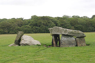
Presaddfed Burial Chamber is a listed monument in Anglesey, north Wales, comprising two Neolithic chamber tombs. It is a scheduled ancient monument and is located a short distance northwest of Bodedern. It is maintained by Cadw.

Din Dryfol is a Neolithic burial chamber on Anglesey, in Wales. It is a scheduled monument and is maintained by Cadw. The monument is near Bethel. Three phases of use have been identified, all dating from the Neolithic period.

The Menai Strait fish weirs are historically important fishing traps used in the fast-flowing tidal waters of the Menai Strait, which separates Anglesey from the rest of North Wales. The strait was particularly well suited to utilising fish weirs. The tidal waters pull huge volumes of water past the coastline with every tide, and the weirs and traps enabled fish to be concentrated into small holding areas from which they can be readily caught. Such methods are thought to have been used from earliest times, but the submerged and standing remains along both the Anglesey and Gwynedd coasts are from medieval and post-medieval periods, and in some cases were still in use into the 20th century.

Porth Wen Brickworks first built by Charles E Tidy, is now a disused Victorian brickworks which produced fire bricks, made from quartzite (silica) used to line steel-making furnaces. The substantial remains include a number of buildings and the remains of some of the machinery, but has some damage from sea erosion. The site is a scheduled monument.

The Isle of Anglesey, a principal area off the north-west coast of Wales, includes the islands of Anglesey, Holy Island and some islets and skerries. It covers an area of 711 km2 (275 sq mi) and in 2021 the population was approximately 68,900.


