Ringfort

Last updated

The ringfort at Rathrar in County Roscommon, Ireland Multivallate Ringfort at Rathrar (Rathbarna Enclosure Complex), Co Roscommon, Ireland.jpg
The ringfort at Rathrar in County Roscommon, Ireland
The Grianan Ailigh
in County Donegal, Ireland, is one of the more impressive stone-walled ringforts Grianan of Aileach scenic view 01.png
The Grianán Ailigh in County Donegal, Ireland, is one of the more impressive stone-walled ringforts

Ringforts or ring forts are small circular fortified settlements built during the Bronze Age, Iron Age and early Middle Ages up to about the year 1000 AD. They are found in Northern Europe, especially in Ireland. There are also many in South Wales and in Cornwall, where they are called rounds. [1] Ringforts come in many sizes and may be made of stone or earth. Earthen ringforts would have been marked by a circular rampart (a bank and ditch), often with a stakewall. Both stone and earthen ringforts would generally have had at least one building inside.

Contents

Distribution

Ireland

The distribution of known, surviving ringforts in Ireland Ringfort distribution Ireland.png
The distribution of known, surviving ringforts in Ireland

In Irish language sources they are known by a number of names: ráth (anglicised rath, also Welsh rath), lios (anglicised lis; cognate with Cornish lis), [2] caiseal (anglicised cashel), cathair (anglicised caher or cahir; cognate with Welsh caer, Cornish and Breton ker) and dún (anglicised dun or doon; cognate with Welsh and Cornish din). [3] The ráth and lios was an earthen ringfort; the ráth being the enclosing bank and the lios being the open space within. [4] The caiseal and cathair was a stone ringfort. [3] The term dún was usually used for any stronghold of importance, which may or may not be ring-shaped. [3]

In Ireland, over 40,000 sites have been identified as ringforts and it is thought that at least 50,000 ringforts existed on the island. [5] They are common throughout the country, with a mean density of just over one ringfort within any area of 2 km2 (0.8 sq mi). It is likely that many have been destroyed by farming and urbanisation. However, many hitherto unknown ringforts have been found thanks to early Ordnance Survey maps, aerial photography, and the archaeological work that has accompanied road-building.

England and Wales

In Cornwall, [1] parts of Devon, and south Wales, enclosed settlements share many characteristics with their Irish counterparts, [6] including the circular shape and souterrains ( fogous ), and their continuing occupation from the Iron Age into the early medieval period; the form later influencing the distinctive circular shell-keeps found across the medieval Severnside region. [7] Few Cornish examples have been archaeologically excavated, with the exception of Trethurgy Rounds.

Scandinavia

Hillforts are also known from Scandinavia, of which nineteen can be found on the Swedish island of Öland alone.

These hillforts are not to be confused with Viking ring fortresses, of which seven are known from Denmark and southern Sweden, all from around 980 in the Viking Age. The Viking forts all share a strikingly similar design and are collectively referred to as Trelleborgs, after the first excavated fortress of that type in 1936. All the Viking ring fortresses are believed to have been built within a very short timeframe, during the reign of Harold Bluetooth, but for yet unknown military purposes. They might have served as boot camps for Sweyn Forkbeard's men before his invasion of England in 1013. [8]

Chronology

The debate on chronology is primarily a result of the huge number of ringforts and the failure of any other form of settlement site to survive to modern times in any great quantity from the period before the Early Christian period or from Gaelic Ireland after the Anglo-Norman arrival. Three general theories mark the debate on the chronology of Irish ringforts; firstly the theory that wishes to date ringforts back into the Iron Age period; secondly, the theory that seeks to see the continuation of ringfort habitation into the Later Medieval and even the Modern Period; finally, the more common and generally accepted theory[ citation needed ] that ringforts were a product of the second half of the first millennium, a theory which has been given greater definition by Matthew Stout in recent years. According to the authoritative New History of Ireland (2005), "archaeologists are agreed that the vast bulk of them are the farm enclosures of the well-to-do of early medieval Ireland". [5]

Theories

Ringfort on the island of Inishmaan, Aran Islands, Ireland InishmaanRingfort2.jpg
Ringfort on the island of Inishmaan, Aran Islands, Ireland

The theories that the ringfort either pre- or post-dates the Early Middle Ages in Ireland, are both based on essentially the same premise, as is highlighted here by Tadhg O'Keefe in relation to the latter argument:

The a priori case for attributing some ringforts to the Later Middle Ages... is based on the absence of any other settlement form of appropriate date in those landscapes. In other words, if the Gaelic-Irish did not live in ringforts, where did they live?

Dating from the Iron Age

The conjecture that ringforts can be seen to have evolved from and be part of an Iron Age tradition has been expanded by Darren Limbert. This hypothesis is based on a number of re-interpretations of the available evidence, as well as concern over the available evidence. As only a small portion of ringforts have undergone total excavation, and the fact that these excavations have not taken place on anything like a national level, the evidence is insufficient to place all ringforts and the origins of them within the Early Christian period.

Caher on Black Head, County Clare, with karst terrain in foreground Caher dun Irghuis.jpg
Caher on Black Head, County Clare, with karst terrain in foreground

Limbert argues instead, that the ringfort should be seen in the context of a variety of similar developments in Britain and the European Continent, particularly in Iberia and Gaul. While conceding that most ringforts were built in the Early Christian period, he suggests a link between the arrival of Eóganachta dynasty in Munster c. 400 AD, and the introduction of ringforts. In support of this he notes that: "The other major Eoganachta ringforts [other than Cashel] of Ballycatten, Garranes and possibly Garryduff, despite limited stratigraphic discernment, have produced artefacts of ambiguously early origins. Also, their defensive nature,... supports an intrusion of a Celtic warrior caste..." The similarity with South Welsh 'raths' and Cornish 'rounds' suggests a degree of cultural interaction between Western British and Irish populations, however differences in dates of occupation mean this cannot be confirmed. [1]

On the island of Öland, Sweden, nineteen ringforts have been identified, including Eketorp, a site that has been completely excavated and that one may visit. Currently, excavations are ongoing at Sandby borg, which was the site of a massacre in the 5th century A.D.

It is also possible that the Hill of Tara is an early type of ringfort.

Use continuing into the Later Medieval period

At the opposite end of the spectrum to this, the argument has been put forward to suggest that ringforts were in use, if not being built in the Later Medieval and possibly Early Modern period in Gaelic Ireland. This argument is primarily two-fold, ringforts were gradually converted into what would more generally be considered as mottes today, and there is some slight and contentious archaeological evidence that points to the habitation and construction of obvious ringforts in this later medieval period.

From a morphological viewpoint, and probably also from the view of the contemporary person, there is little to distinguish a ringfort from a small earthwork castle or motte. Indeed, in a number of cases it would appear that either the Normans converted existing ringforts into the basis of the future construction of mottes and earthworks, or that the Gaelic Irish, through the use of raised raths, sought to emulate the Norman example. Some L Plan Castles, such as Balingarry Castle in Ireland originated as ringforts.

This theory is supported by a number of excavations, most notably the results of the Castleskreen II excavation, and the raised raths at Piper's Fort, and Ballyfounder, County Limerick, which seem to have been converted into mottes in the case of Castleskreen II or in the later cases, built in imitation of such constructions. If one were to accept a defensive function for ringforts, it would seem that after the introduction of more complex forms of defensive structures into Ireland this would naturally lead to the use of ringforts and raised raths in a manner analogous to the contemporary Norman buildings.

7th to 10th centuries

While it would seem probable that some ringforts may have seen continuation in the Later Medieval period as adapted or imitation mottes it seems doubtful if the continuation that ringforts were still being built on a more general scale throughout the country, and the evidence put forward for such a theory would appear quite slim. The excavations which support such a theory, most notably Rynne's excavation at Shannon Airport of Garrynamona which is suggestive of a 15th-century ringfort being constructed, have failed to win any form of widespread popular acceptance.

The most common theory however is that ringforts are the product of the later half of the first millennium, a theory that has generally been supported by the excavated evidence of the period, and one that has seen remarkable if slightly ambitious definition from Matthew Stout. In his work The Irish Ringfort, Stout has sought to use the radiocarbon and dendrochronological dates from 114 ringforts and associated sites to find an overall date pattern for the use of ringforts; and through this has placed over half of all ringforts in the period 540 AD to 884 AD with two-thirds falling within the 600 AD to 900 AD period. While this method has brought the dating of the ringfort phase of Irish history to an ever more accurate level, certain problems do exist with his analysis. Firstly, as he notes himself, the research is overly biased towards Ulster (64% of dated sites were from Ulster), and the dates come from a very small sample of sites relative to the total number of ringforts. Finally, Stout's use of radiocarbon dating is to one standard deviation, which means that there is an approximately one third chance that the data offered is inaccurate by up to 100 years on either side. Yet despite these difficulties, Stout's analysis has to a large extent brought a degree of finality to the debate of the dating and use of ringforts, with it being more or less certain that the vast majority were probably occupied and constructed in the second half of the first millennium. His analysis is further supported by Gerald of Wales who commented that ringforts in Ireland, were known as Daneforts, and that they had been abandoned by the late 12th century when he was in Ireland.

A typical ringfort incorporated into field boundaries in County Tyrone, Northern Ireland Rath - geograph.org.uk - 304314.jpg
A typical ringfort incorporated into field boundaries in County Tyrone, Northern Ireland

Function

In agriculture

It has traditionally been understood that the ringfort was a dispersed farmstead, the home of a free man and his family and the centre of a mixed agricultural economy to a large extent dominated by cattle. A medieval Irish law text describes a prosperous farmer - boaire in Old Irish - as having a dwelling house, a sheep-pen, a calf-pen and a pig-sty - it would seem that these were all within the ring-fort. [9]

Evidence suggests that not all ringforts were farmsteads, but rather that ringforts appeared to have fulfilled a variety of other functions as well. The most celebrated example of this is Garryduff II in County Cork. This ringfort which is overlooked and in close proximity to another larger ringfort, Garryduff I, has provided archaeologists with no evidence of habitation or settlement, and the pre-eminent theory at the moment is that this ringfort was possibly used as an enclosure for livestock.

However, this interpretation is still the most commonly held in academic, archaeological and popular debate, although pollen studies and other evidence have greatly modified the traditional view of the dominance of livestock as opposed to arable farming in early medieval Ireland, making it clear that cereal production was much more important than once thought in the Early Medieval period. [10]

In industry

Other sites have provided evidence that ringforts may not have principally been farmsteads, but rather had a more diverse and significant role in the economy. A good example of this is provided by the large, tri-vallate ringfort in Garannes, County Cork, which offers no evidence for habitation or settlement but provides a great deal of evidence to suggest that the site had an industrial nature. Furthermore, the finds of continental pottery at the site, suggests that the site was trading with the continent and/or may have been acting as a gateway centre for similar high status goods into the local economy. Both Garannes, and especially Garryduff II, highlight the other roles that ringforts may have had in early Christian Ireland. While it would seem that most ringforts fitted the traditional explanation as farmsteads, that should not be used as a blanket explanation. A number of other functions for many of the surviving ringforts, such as those outlined above and possibly other settlement functions, still need to be considered.

The gate of Chun Castle in Cornwall Chun Castle - geograph.org.uk - 1065624.jpg
The gate of Chûn Castle in Cornwall

In defence

A ringfort is a defensive feature that would appear to be obvious both from the name with the defensive implications that fort implies, and also from the generally understood morphological definition of the ringfort, with the banks and fosse been commonly seen as defensive. Indeed, in S. Ó Ríordáin's common morphological definition, he refers to the banks and fosses of the ringfort as defences.

One presumes that the ringfort had a defensive aspect, and in a cattle-dominated society it is generally argued that the purpose of the ringfort was to provide protection to a small community and their livestock during a 'hit and run' raid for cattle, the idea being that the ringfort would provide adequate defence for a small period of time. This theory is strengthened by the idea of 'visual territories' which operates from the assumption that all ringfort in a region were probably occupied contemporarily, and that in a particular area one ringfort would be in the sight of at least one other neighbouring ringfort so that if one ringfort were attacked, relief would possibly come from a neighbouring one. Furthermore, a number of aspects of the generally circular nature of the ringfort highlight the defensive advantages, most notably that a circle as a shape "offered broad perspectives of approaching attackers and allowed the maximum area to be enclosed relative to the length of the bank constructed."

In aristocracy

While defence may be expanded as the modern day explanation for the surrounding banks of a ringfort, this was not the contemporary explanation, rather the explanations forthcoming from the Early Christian texts stress the importance and role of the banks in signifying nobility, kingship and authority. This relationship can be quite clearly seen in the following extract from the Críth Gablach:

What is the due of a king who is always in residence at the head of his tuath? Seven score feet of perfect feet are the measure of his stockade on every side. Seven feet are the thickness of its earthwork, and twelve feet its depth. It is then that he is a king, when ramparts of vassalage surround him. What is the rampart of vassalage? Twelve feet are the breadth of its opening and its depth and its measure towards the stockade. Thirty feet are its measure outwardly. [11]

As can be seen from the above text, the relationship between the banks of a ringfort and vassalage is quite clear. With the argument being that the more elaborate the ringfort, usually in the forms of multiple outlying banks, the higher the status of the occupant. This emphasis on status in the function of the ringfort over that of defence would explain a number of defensive weaknesses of the ringfort. Banks, or multiples of them, would not appear to offer the best return to their builders for their defensive value in comparison to a fence or a hedge. Also, few of the ringforts where buildings have been found inside, would be able to survive a night with a herd of cattle brought inside the ringfort. Furthermore, little effort would appear to have been expended on the upkeep of ditches and fosses to prevent decay and silting. Another key difficulty with viewing the ringfort primarily as a defensive unit is the general lack of ability to fight out from the ringforts, from the top of the banks.

Legends and folklore concerning ringforts and rounds

The materials used to construct ringforts frequently disintegrated over time. Tradition associated their circular remains with fairies and leprechauns, and they were called fairy forts". Castle Pencaire on Tregonning Hill was regarded as the abode of giants. [12] Chun Castle in Morvah is related as the home of the giant Denbras who is buried by the character Tom at Chun Quoit from oral folklore recorded by William Bottrell published 1870. [13] Kelly Rounds (Castle Kilibury) in Triggshire is often proposed as the location of King Arthur's Celliwig, known from the Welsh poem Pa Gwr yw y Porthawr? and described in the 11th century Culhwch and Olwen. Castle Dore is often proposed as the court of King Mark (Mergh Cunomor / Marcus Cunomorus) in the romance Drustan hac Yseult, the doomed hero sailing the seas from Brittany to Ireland to seek his love.

List of notable ringforts

Ireland

The royal sites of Ireland are also sometimes called ringforts, although their role seems to have been mainly ceremonial. They include:

Cornwall (Cornish rounds)

Denmark (Viking ring fortresses)

Sweden

Germany

Estonia

See also

Notes

  1. 1 2 3 4 "Flying Past - The Historic Environment of Cornwall: Enclosed Settlements". www.historic-cornwall.org.uk. Retrieved 2 April 2018.
  2. 1 2 "Access to Monuments - Helsbury". www.historic-cornwall.org.uk. Retrieved 2 April 2018.
  3. 1 2 3 Edwards, Nancy. The Archaeology of Early Medieval Ireland. Routledge, 2006. Page 12.
  4. Seán P Ó Ríordáin, Ruaidhrí De Valera. Antiquities of the Irish countryside. Taylor & Francis, 1979. Page 30.
  5. 1 2 New History, 550
  6. Castles in the Medieval Landscape, OH Creighton & JP Freeman
  7. Medieval Severnside: the Welsh Connection, R.A. Griffiths, 1994
  8. Marszal, Andrew. "Viking 'ring fortress' discovered in Denmark", The Telegraph, 6 September 2014 Retrieved 18 May 2017.
  9. Kelly, Fergus (1997). Early Irish Farming. Dublin: Dublin Institute for Advanced Studies. p. 364.
  10. New History, 559–563
  11. MacNeill, John (1923). Ancient Irish law: the law of status or franchise. Franchise. Dublin: Hodges, Figgis, & co. p. 305.
  12. "Access to Monuments - Castle Pencaire". www.historic-cornwall.org.uk. Retrieved 2 April 2018.
  13. William Bottrell, Traditions and Hearthside Stories of West Cornwall, Vol. 1, 1870 https://www.sacred-texts.com/neu/celt/swc1/index.htm
  14. "Access to Monuments - Castle-an-Dinas". www.historic-cornwall.org.uk. Retrieved 2 April 2018.
  15. "Access to Monuments - Castle Dore". www.historic-cornwall.org.uk. Retrieved 2 April 2018.
  16. "Access to Monuments - Chun Castle". www.historic-cornwall.org.uk. Retrieved 2 April 2018.
  17. "Heritage Gateway - Results". www.heritagegateway.org.uk. Retrieved 2 April 2018.
  18. "Page not found - Cornwall Council". cornwall.gov.uk. Retrieved 2 April 2018.{{cite web}}: Cite uses generic title (help)
  19. "Flying Past - The Historic Environment of Cornwall: Power and Authority". www.historic-cornwall.org.uk. Retrieved 2 April 2018.

Related Research Articles

<span class="mw-page-title-main">Broch</span> Type of Iron Age drystone hollow-walled structure

In archaeology, a broch is an Iron Age drystone hollow-walled structure found in Scotland. Brochs belong to the classification "complex Atlantic roundhouse" devised by Scottish archaeologists in the 1980s.

<span class="mw-page-title-main">Hillfort</span> Type of earthworks used as a fortified refuge or defended settlement

A hillfort is a type of earthwork used as a fortified refuge or defended settlement, located to exploit a rise in elevation for defensive advantage. They are typically European and of the Bronze Age or Iron Age. Some were used in the post-Roman period. The fortification usually follows the contours of a hill and consists of one or more lines of earthworks, with stockades or defensive walls, and external ditches. If enemies were approaching, the civilians would spot them from a mile away.

<span class="mw-page-title-main">Maiden Castle, Dorset</span> Iron Age hill fort in Dorset, England

Maiden Castle is an Iron Age hillfort 1.6 mi (2.6 km) southwest of Dorchester, in the English county of Dorset. Hill forts were fortified hill-top settlements constructed across Britain during the Iron Age.

<span class="mw-page-title-main">Rathcroghan</span> Complex of archaeological sites in Roscommon, Ireland

Rathcroghan is a complex of archaeological sites near Tulsk in County Roscommon, Ireland. It is identified as the site of Cruachan, the traditional capital of the Connachta, the prehistoric and early historic rulers of the western territory. The Rathcroghan Complex is a unique archaeological landscape with many references found in early Irish medieval manuscripts.

<span class="mw-page-title-main">Cahercommaun</span>

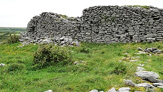
Cahercommaun, sometimes Cahercommane, is a triple stone ringfort on the south-east edge of the Burren area, in Kilnaboy, near the rural village of Carran, in County Clare, Ireland. It was built in the 9th century.

<span class="mw-page-title-main">Navan Fort</span> Ceremonial and possible royal site near Armagh, Northern Ireland

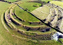
Navan Fort is an ancient ceremonial monument near Armagh, Northern Ireland. According to tradition it was one of the great royal sites of pre-Christian Gaelic Ireland and the capital of the Ulaidh. It is a large circular hilltop enclosure—marked by a bank and ditch—inside which is a circular mound and the remains of a ring barrow. Archeological investigations show that there were once buildings on the site, including a huge roundhouse-like structure that has been likened to a temple. In a ritual act, this timber structure was filled with stones, deliberately burnt down and then covered with earth to create the mound which stands today. It is believed that Navan was a pagan ceremonial site and was regarded as a sacred space. It features prominently in Irish mythology, especially in the tales of the Ulster Cycle. According to the Oxford Dictionary of Celtic Mythology, "the [Eamhain Mhacha] of myth and legend is a far grander and mysterious place than archeological excavation supports".

<span class="mw-page-title-main">Grianan of Aileach</span> Hillfort in County Donegal, Ireland

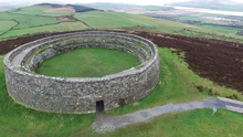
The Grianan of Aileach, sometimes anglicised as Greenan Ely or Greenan Fort, is a hillfort atop the 244 metres (801 ft) high Greenan Mountain at Inishowen in County Donegal, Ireland. The main structure is a stone ringfort, thought to have been built by the Northern Uí Néill, in the sixth or seventh century CE; although there is evidence that the site had been in use before the fort was built. It has been identified as the seat of the Kingdom of Ailech and one of the royal sites of Gaelic Ireland. The wall is about 4.5 metres (15 ft) thick and 5 metres (16 ft) high. Inside it has three terraces, which are linked by steps, and two long passages within it. Originally, there would have been buildings inside the ringfort. Just outside it are the remains of a well and a tumulus.

<span class="mw-page-title-main">Caherconnell Stone Fort</span> Medieval stone ringfort in the Burren, County Clare, Ireland.

Caherconnell is an exceptionally well-preserved medieval stone ringfort in region known as the Burren, County Clare, Ireland. It lies about 1 km south of the Poulnabrone dolmen.

<span class="mw-page-title-main">Eketorp</span>

Eketorp is an Iron Age fort, located in southeastern Öland, Sweden, and extensively reconstructed and enlarged in the Middle Ages. Throughout the ages the fortification has served a variety of somewhat differing uses: from defensive ringfort, to medieval safe haven and thence a cavalry garrison. In the 20th century it was further reconstructed to become a heavily visited tourist site and a location for re-enactment of medieval battles. Eketorp is the only one of the 19 known prehistoric fortifications on Öland that has been completely excavated, yielding a total of over 24,000 individual artifacts. The entirety of southern Öland has been designated as a World Heritage Site by UNESCO. The Eketorp fortification is often referred to as Eketorp Castle.

<span class="mw-page-title-main">History of Dublin to 795</span>

Dublin is Ireland's oldest known settlement. It is also the largest and most populous urban centre in the country, a position it has held continuously since first rising to prominence in the 10th century. The historic town grew up on the southern bank of the River Liffey, a few kilometres upstream from the river's outfall into Dublin Bay. The original settlement was situated on a ridge overlooking a shallow ford in the river, which had probably been a regular crossing-point since earliest times. The bedrock underlying the city is calp limestone, a dark shaly sedimentary rock which was once quarried locally and whose mottled grey appearance can still be seen today in some of the city's oldest buildings. Overlying this is a layer of much looser boulder clay of varying thickness.

<span class="mw-page-title-main">Ranaghan</span> Townland in County Westmeath, Ireland

Ranaghan is a townland and archaeological site in County Westmeath, Ireland.

<span class="mw-page-title-main">Ringwork</span> Form of fortified defensive structure

A ringwork is a form of fortified defensive structure, usually circular or oval in shape. Ringworks are essentially motte-and-bailey castles without the motte. Defences were usually earthworks in the form of a ditch and bank surrounding the site.

<span class="mw-page-title-main">Dún Ailinne</span>

Dún Ailinne is an ancient ceremonial site on the hill of Cnoc Ailinne (Knockaulin) in County Kildare, Ireland. It is southwest of Kilcullen, near the R418 road to Athy. It is a large circular enclosure covering most of the hilltop; about 13 hectares. While there is no longer anything visible on the ground surface, archeological investigations show that there were once circular timber structures inside the enclosure during the Irish Iron Age.

<span class="mw-page-title-main">Circular rampart</span> Embankment built in the shape of a circle

A circular rampart is an embankment built in the shape of a circle that was used as part of the defences for a military fortification, hill fort or refuge, or was built for religious purposes or as a place of gathering.

Hillforts in Britain refers to the various hillforts within the island of Great Britain. Although the earliest such constructs fitting this description come from the Neolithic British Isles, with a few also dating to later Bronze Age Britain, British hillforts were primarily constructed during the British Iron Age. Some of these were apparently abandoned in the southern areas that were a part of Roman Britain, although at the same time, those areas of northern Britain that remained free from Roman occupation saw an increase in their construction. Some hillforts were reused in the Early Middle Ages, and in some rarer cases, into the Later Medieval period as well. By the early modern period, these had essentially all been abandoned, with many being excavated by archaeologists in the nineteenth century onward.

<span class="mw-page-title-main">Promontory forts of Cornwall</span> Cliff castles in north-west Europe

Cornish promontory forts, commonly known in Cornwall as cliff castles, are coastal equivalents of the hill forts and Cornish "rounds" found on Cornish hilltops and slopes. Similar coastal forts are found on the north–west European seaboard, in Normandy, Brittany and around the coastlines of the British Isles, especially in Wales, Scotland and Ireland. Many are known in southwest England, particularly in Cornwall and its neighbouring county, Devon. Two have been identified immediately west of Cornwall, in the Isles of Scilly.

<span class="mw-page-title-main">Cahermore ringfort</span>

Cahermore ringfort or sometimes Caher Mór or "Ballyallaban stone fort" is a ringfort south of Ballyvaughan in the Burren area, in County Clare, Ireland. It is a National Monument.

<span class="mw-page-title-main">Lesingey Round</span>

Lesingey Round is a ringfort, a smaller type of hillfort, about 1 mile (1.6 km) west of Penzance, in Cornwall, England. It is a scheduled monument.

Rathdown Castle is a ruined castle and ancient settlement site located in County Wicklow, Ireland.

References

Further reading/sources