This article is about the area of the United Kingdom. For the Australian state, see New South Wales.
Map of one definition of South Wales, combining common definitions of South East and South West Wales, including Carmarthenshire and Pembrokeshire, which may also be considered West Wales. Areas shaded light red are historically considered South Wales, but may be considered Mid Wales today. Other definitions of the region exist.
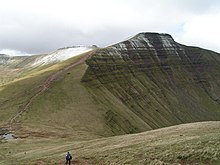
Pen y Fan 2,907 ft (886 metres)17-18th century map of South Wales with Monmouthshire considered in this map to be part of England.
A point of some discussion is whether the first element of the name should be capitalised: 'south Wales' or 'South Wales'. As the name is a geographical expression rather than a specific area with well-defined borders, style guides such as those of the BBC[2] and The Guardian[3] use the form 'south Wales'. In a more authoritative style guide, the Welsh Government, in their international gateway website, Wales.com, state that it should always be capitalised.[4] It is always capitalised on motorway signs.
The Laws in Wales Acts 1542 created the Court of Great Sessions in Wales based on four legal circuits. The Brecon circuit served the counties of Brecknockshire, Radnorshire and Glamorgan while the Carmarthen circuit served Cardiganshire, Carmarthenshire and Pembrokeshire. Monmouthshire was attached to the Oxford circuit for judicial purposes. These seven southern counties were thus differentiated from the six counties of north Wales.
The Court of the Great Sessions came to an end in 1830, but the counties survived until the Local Government Act 1972 which came into operation in 1974. The creation of the county of Powys merged one northern county (Montgomeryshire) with two southern ones (Breconshire and Radnorshire).
There are thus different concepts of south Wales. Glamorgan and Monmouthshire are generally accepted by all as being in south Wales. But the status of Breconshire or Carmarthenshire, for instance, is more debatable. In the western extent, from Swansea westwards, local people might feel that they live in both south Wales and west Wales. Areas to the north of the Brecon Beacons and Black Mountains are generally considered to be in Mid Wales. The valleys and upland mountain ridges were once a very rural area noted for its river valleys and ancient forests and lauded by romantic poets such as William Wordsworth as well as poets in the Welsh language, although the interests of the latter lay more in society and culture than in the evocation of natural scenery. This natural environment changed to a considerable extent during the early Industrial Revolution when the Glamorgan and Monmouthshire valley areas were exploited for coal and iron. By the 1830s, hundreds of tons of coal were being transported by barge to ports in Cardiff and Newport. In the 1870s, coal was transported by rail transport networks to Newport Docks, at the time the largest coal exporting docks in the world, and by the 1880s coal was being exported from Barry, Vale of Glamorgan.
The Marquess of Bute, who owned much of the land north of Cardiff, built a steam railway system on his land that stretched from Cardiff into many of the South Wales Valleys where the coal was being found. Lord Bute then charged fees per ton of coal that was transported out using his railways. With coal mining and iron smelting being the main trades of south Wales, many thousands of immigrants from the Midlands, Scotland, Ireland, Cornwall and even Italy came and set up homes and put down roots in the region. Very many came from other coal mining areas such as Somerset, the Forest of Dean in Gloucestershire and the tin mines of Cornwall such as Geevor Tin Mine, as a large but experienced and willing workforce was required. Whilst some of the migrants left, many settled and established in the south Wales Valleys between Swansea and Abergavenny as English-speaking communities with a unique identity. Industrial workers were housed in cottages and terraced houses close to the mines and foundries in which they worked. The large influx over the years caused overcrowding which led to outbreaks of Cholera, and on the social and cultural side, the near-loss of the Welsh language in the area.
Despite the intense industrialisation of the coal mining valleys, many parts of the landscape of South Wales such as the upper Neath valley, the Vale of Glamorgan and the valleys of the River Usk and River Wye remain distinctly beautiful and unspoilt and have been designated Sites of Special Scientific Interest. In addition, many once heavily industrialised sites have reverted to wilderness, some provided with a series of cycle tracks and other outdoor amenities. Large areas of forestry and open moorland also contribute to the amenity of the landscape.
Industrialised areas in the 19th and 20th centuries
Merthyr Tydfil (Welsh: Merthyr Tudful) grew around the Dowlais Ironworks which was founded to exploit the locally abundant seams of iron ore, and in time it became the largest iron-producing town in the world. New coal mines were sunk nearby to feed the furnaces and in time produced coal for export. By the 1831 census, the population of Merthyr was 60,000—more at that time than Cardiff, Swansea and Newport combined—and its industries included coal mines, iron works, cable factory, engine sheds and sidings and many others. The town was also the birthplace of Joseph Parry, composer of the song Myfanwy.
Aberfan: The Merthyr Vale colliery began to produce coal in 1875. Spoil from the mine workings was piled on the hills close to the village which grew nearby. Tipping went on until the 1960s. Although nationalised, the National Coal Board failed to appreciate the danger they had created. In October 1966, heavy rain made the giant coal tip unstable, resulting in the Aberfan disaster. The recent dumping of small particles of coal and ash known as 'tailings' seems to have been partly responsible. A 30-foot-high (9m) black wave tore downhill across the Glamorganshire Canal and swept away houses on its path towards the village school. 114 children and 28 adults were killed.
The Rhondda Valleys (Rhondda Fach and Rhondda Fawr) housed around 3,000 people in 1860, but by 1910 the population had soared to 160,000. The Rhondda had become the heart of a massive South Wales coal industry. Mining accidents below ground were common, and in 1896 fifty-seven men and boys were killed in a gas explosion at the Tylorstown Colliery. An enquiry found that the pit involved had not been properly inspected over the previous 15 months.
Ebbw Vale, the valley of the Ebbw River which stretches from the town of Ebbw Vale to Newport, includes the mining towns and villages of Newbridge, Risca, Crumlin, Abercarn and Cwmcarn. The Carboniferous Black Vein coal seams in the area lay some 900 feet (275 metres) below the surface and the mining activity associated with it was responsible for many tragic subsurface explosions, roof collapses and mining accidents.
Now the Valleys' heavy industrial past is overprinted with urban regeneration, tourism and multi-national investment. Large factory units, either empty or turned over to retail use, bear witness to the lack of success in replacing older industries.
Language
The native language of the majority of people in South Wales is English, but there are many who also speak Welsh. In western parts of Glamorgan, particularly the Neath and Swansea Valleys, there remain significant Welsh-speaking communities such as Ystradgynlais and Ystalyfera, which share a heritage with other ex-anthracite mining areas in eastern Carmarthenshire, as much as with the Glamorgan valleys.
The local slang, dialect and phrases of the South Wales Valleys communities have been referred to as 'Wenglish', and are often used with comic effect.[6] The dialect is found in such coastal towns as Barry, as featured in the BBC comedy series, Gavin & Stacey.
A significant number of people from ethnic minority communities speak another language as their first language, particularly in Cardiff and Newport. Commonly spoken languages in some areas include Punjabi, Bengali, Arabic, Somali and Chinese, and increasingly Central European languages such as Polish.
In the 19th and early 20th centuries, there was a vigorous literary and musical culture centred round eisteddfodau.[7][8][9] Despite a few timid attempts to emulate this literature in English, it can be argued that few writers seem to connect with either the landscape or the literary tradition.[10] The one exception, to some extent, can be considered to be Dylan Thomas.[11]
Culture
This section needs expansion. You can help by adding to it. (March 2023)
The South Wales landscape is marked by numerous chapels, places of worship (past and present) of the various Christian Nonconformist congregations. The Baptist congregation at Ilston, Gower, moved to Swansea, Massachusetts,[12] but after the restoration of the Anglican worship with the issue of the Book of Common Prayer in 1662, several "gathered" churches survived belonging to the Baptist, Independent and Presbyterian denominations. In the 18th century members of some of these congregations became dissatisfied with the theological innovations of some trained ministers, and created new congregations such as that at Hengoed near Ystrad Mynach.[13] In the same century, churches were sometimes involved in the Methodist movement, especially at Groeswen and Watford near Caerphilly, which both received frequent visits from John Wesley[14][15] The largest denomination, however, became the Calvinist Methodists (later the Presbyterian Church of Wales), whose distinctive grey stone chapels can be seen in many parts.
These were mainly Welsh-language congregations. Anglicanism in South Wales became autonomous from the Church of England with the Welsh Church Act 1914, but the immediate demise of the denomination feared at that time has not taken place in the Church in Wales.[16][17] There are a number of Brethren Assemblies in Cardiff and in the Swansea area and Free Presbyterian Churches in Rhiwderin, near Newport and at Merthyr Tydfil. The Roman Catholic community, despite systematic persecution, survived in the 17th to 19th centuries, especially in Brecon and among minor gentry such as the Vaughans of Welsh Bicknor, on the Monmouthshire–Herefordshire border.[18][19] Among members of foreign origin of later urban Catholic congregations were the Bracchi, Italians in the café and catering trades often from Bardi in the Apennines.[20][citation needed]
Post-war diversity has brought mosques, especially in Cardiff and Newport, Sikhgurdwaras, including one on the mountain near Abercynon and a growing number of Evangelical and Pentecostal congregations. These often add a strongly international element into local life, such as the "Pont" twinning project between Pontypridd and Mbale, Uganda, and the creation of "Fairtrade" relationships with primary producers worldwide.[citation needed]
Industry today
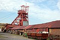
The former heavy industries of coal and iron production have disappeared since the economic struggles of the 1970s, with the closures of that decade continuing sharply into the 1980s, and by July 1985 just 31 coal pits remained in the region.[21] Further closures left the region with just one deep mine by the early 1990s,[22] and this finally closed in January 2008, by which time it had transferred to private ownership after being sold off by the National Coal Board.[23]
These industries have since largely been replaced by service sector industries.
The cities along the M4 corridor are home to a number of high-profile blue-chip companies such as Admiral Insurance, Legal & General and the Welsh-based Principality Building Society. A large number of telephone call centres are located in the region and in particular in the Valleys area. Merthyr Tydfil is home to the principal UK call centre for German mobile telephone company, T-Mobile. Many jobs are also provided in small-scale and family businesses.[24]
One site of note on the M4 corridor is Port Talbot Steelworks – the largest steel producer in the UK and one of the biggest in Europe.[25]
The television and film sectors are fast becoming a major industry in South Wales. In 2021, the Welsh screen sector saw a turnover of £575 million.[26] Prominent film studios have been established in Cardiff (Wolf Studios Wales, Seren Stiwdios, Enfys Studios) as well as Bridgend (Dragon Studios) and Swansea (Bay Studios).[27]
Glamorgan, or sometimes Glamorganshire, was one of the thirteen historic counties of Wales in the south of Wales. Originally an early medieval petty kingdom of varying boundaries known in Welsh as Morgannwg, which was then invaded and taken over by the Normans as the Lordship of Glamorgan. The area that became known as Glamorgan was both a rural, pastoral area, and a conflict point between the Norman lords and the Welsh princes. It was defined by a large concentration of castles.
Powys is a county and preserved county in Wales. It borders Gwynedd, Denbighshire, and Wrexham to the north; the English ceremonial counties of Shropshire and Herefordshire to the east; Monmouthshire, Blaenau Gwent, Merthyr Tydfil, Caerphilly, Rhondda Cynon Taf, and Neath Port Talbot to the south; and Carmarthenshire and Ceredigion to the west. The largest settlement is Newtown, and the administrative centre is Llandrindod Wells.
Brecknockshire, also known as the County of Brecknock, Breconshire, or the County of Brecon, was one of the thirteen historic counties of Wales. It was created in 1536 under the Laws in Wales Act 1535. From 1889 it was an administrative county with a county council; the administrative county was abolished in 1974. The county was named after the medieval Welsh territory of Brycheiniog, which was anglicised to "Brecknock" and also gave its name to the county town of Brecon. The county was mountainous and primarily rural.
Porth is a town and a community in the county borough of Rhondda Cynon Taf, within the historic county boundaries of Glamorgan, Wales. Lying in the Rhondda Valley, it is regarded as the gateway connecting the Rhondda Fawr and Rhondda Fach valleys due to both valleys meeting at Porth. The Welsh word "porth" means "gate". Porth is a predominantly English-speaking community.
These are lists of places in Wales.
Rhydyfelin is a large village and part of the community of Pontypridd Town, about two miles to its south east of Pontypridd, in the county borough of Rhondda Cynon Taf. It is on the eastern bank of the River Taff close to the A470, and historically was in the parish of Eglwysilan.
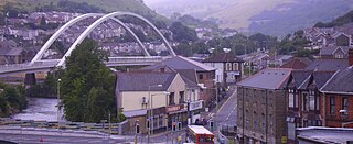
The South Wales Valleys are a group of industrialised peri-urban valleys in South Wales. Most of the valleys run north–south, roughly parallel to each other. Commonly referred to as "The Valleys", they stretch from Carmarthenshire in the west to Monmouthshire in the east; to the edge of the pastoral country of the Vale of Glamorgan and the coastal plain near the cities of Swansea, Cardiff, and Newport.
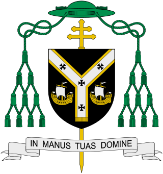
The Archdiocese of Cardiff-Menevia is a Latin archdiocese of the Catholic Church which covers south Wales and the county of Herefordshire in England. The Metropolitan Province of Cardiff covers all of Wales and parts of England. Cardiff's one suffragan diocese is the Diocese of Wrexham.
Pengam is a former coal village and community in the Rhymney Valley, Caerphilly county borough, in Wales. It is also a community, containing itself and the nearby village of Fleur de Lys, and at the 2001 census it has a population of 3,842, rising slightly to 3,848 at the 2011 Census.
The South Wales Coalfield extends across Pembrokeshire, Carmarthenshire, Swansea, Neath Port Talbot, Bridgend, Rhondda Cynon Taf, Merthyr Tydfil, Caerphilly, Blaenau Gwent and Torfaen. It is rich in coal deposits, especially in the South Wales Valleys.
Cwmdare is a village very close to Aberdare, in Rhondda Cynon Taf, Wales. The village's history is intertwined with coal-mining, and since the decline of the industry in the 1980s, it has become primarily a commuter base for the larger surrounding towns of Aberdare and Merthyr Tydfil and Pontypridd, as well as the cities of Cardiff and Swansea.
The Local Government Commission for Wales was established by the Local Government Act 1958 to review the organisation of local government in Wales and to make recommendations for its reform. It delivered its report in 1963 and was dissolved in 1967. Its recommendations were not carried out.
Menter Iaith is a community-based organisation which works to raise the profile of the Welsh language in a specific area. Each local Menter Iaith receives a basic grant from the Welsh Language Board, as well as financial support from a number of other sources, to work with individuals, organisations, and local business to promote the use of Welsh in its area.
Scouting in Wales provides an overview of Scouting activities in Wales. Scout troops have existed in the country since 1908 with the largest number of Scouts and volunteer leaders today linked to the Scout Association of the United Kingdom. This is done through ScoutsCymru, the Welsh Scout Council who split the region further into four regions and a total of 12 Scout Areas. In addition to the Scout Association, there are also traditional Scouting groups belonging to the Baden-Powell Scouts' Association and a number of Scouting clubs within Universities which are affiliated to the Student Scout and Guide Organisation.
Rail transport in Cardiff has developed to provide connections to many other major cities in the United Kingdom, and to provide an urban rail network for the city and its commuter towns in southeast Wales. Today, there are three train operating companies in Cardiff: Great Western Railway, CrossCountry and Transport for Wales.
The Cardiff–Newport metropolitan area is a metropolitan area in south east Wales in the United Kingdom. It includes the cities of Cardiff and Newport, with a number of towns in the South Wales Valleys, including Merthyr Tydfil, Pontypridd, Caerphilly, Bridgend and Ebbw Vale. With these outlying settlements the metropolitan area has a population of 1.09 million. Also referred to as the "Cardiff and South Wales Valley metropolitan area", it corresponds to the preserved counties of Gwent and South Glamorgan. It is the largest metropolitan area in Wales, with the next largest being centred on the Swansea Urban Area.
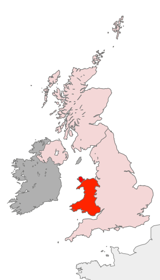
Wales has traditionally been divided into a number of ambiguous and ill-defined areas described as regions, reflecting historical, geographical, administrative, cultural and electoral boundaries within the country. Presently, the most common form of division of Wales into "regions" has been using cardinal and intercardinal references: north or south-west for example. None of the variously described "regions" have official status or defined boundaries; neither is there a fixed number of regions. Various organisations use different regions and combinations of regions for their individual purposes. This includes devolved institutions, such as Visit Wales, Natural Resources Wales, and the Welsh Government itself, using different sets of Wales' regions. Wales is most commonly sub-divided into between two and four regions, with a North–South divide, and North, Mid, South East and South West division being common. This article lists the various terms applied to be the "regions of Wales" and the regions used by various organisations.
The Industrial Revolution in Wales was the adoption and developments of new technologies in Wales in the 18th and 19th centuries as part of the Industrial Revolution, resulting in increases in the scale of industry in Wales.
↑ Rhys, Beti (1984), Dyfed: Bywyd a Gwaith Evan Rees 1850–1923, Dinbych: Gwasg Gee
↑ Walters, Huw (1987), Canu'r Pwll a'r Pulpud: Portread o'r Diwylliant Barddol Cymraeg yn Nyffryn Aman, Barddas: Cyhoeddiadau.
↑ Menai, Huw (1928), "Hills of the Rhondda in Autumn", in Rees-Davies, Ieuan (ed.), Caniadau Cwm Rhondda: Detholiad o Delynegion, Sonedau a Chaneuon Cymraeg a Saesneg, London: Foyle's Welsh Depot, The rust has gathered on the plough, The tide of Autumn here is high, The hills are at their reddest now ....
↑ Vaughan-Thomas, Wynford (1983) [1976], Portrait of Gower, London: Robert Hale, pp.84–85
↑ Jenkins, John Gwili (1931), Hanfod Duw a Pherson Crist: Athrawiaeth y Drindod a Duwdod Crist, yn bennaf yn ei pherthynas â Chymru, Liverpool: Gwasg y Brython.
↑ "Complete list of parishes and clergy". Crockford's Clerical Directory. London: Church House Publishing. 2000–2001..
↑ Cusack O'Keefe, Madge (1970), Four Martyrs of South Wales and the Marches, Archdiocese of Cardiff.
↑ A Mill Hill Father (1969) [1955], Remembered in Blessing: The Courtfield Story, London: Sands & Co, Until the 1890s Courtfield and Welsh Bicknor parish were part of Monmouthshire, and hence in South Wales.
This page is based on this Wikipedia article Text is available under the CC BY-SA 4.0 license; additional terms may apply. Images, videos and audio are available under their respective licenses.