The county is the second most sparsely populated in Wales, with an area of 688 square miles (1,780km2) and a population of 71,500; the latter is a decline of 4,492 since the 2011 census. After Aberystwyth (15,935), the largest towns are Cardigan (4,184) and Lampeter (2,970). Ceredigion is considered a centre of Welsh culture and 45.3% of the population could speak the Welsh language at the 2021 census.
To the west, Ceredigion has 50 miles (80km) of coastline on Cardigan Bay, which is traversed by the Ceredigion Coast Path. Its hinterland is hilly and rises to the Cambrian Mountains in the east, where the highest point is Plynlimon at 752 metres (2,467ft). The mountains are the source of the county's main rivers: the Rheidol, Ystwyth, Aeron and Teifi; the last of these is Ceredigion's boundary with Carmarthenshire and Pembrokeshire for most of its length.
Ceredigion is named after a minor kingdom which occupied approximately the area of the county in the fifth century AD. The contemporary county has the same borders as Cardiganshire, which was established in 1282 by the English king Edward I after his conquest of Wales. In the 18th and early 19th centuries, the county was more industrialised than it is today; lead, silver and zinc were mined in the area, and Cardigan was the largest port in South Wales. The economy later became highly dependent on dairy farming, but is diversifying into areas such as tourism as farming becomes less profitable. The county is home to the National Library of Wales, Aberystwyth University, and the Lampeter campus of University of Wales Trinity St David.
Ceredigion has been inhabited since prehistoric times. A total of 170 hill forts and enclosures have been identified across the county and there are many standing stones dating back to the Bronze Age.[4] Around the time of the Roman invasion of Britain, the area was between the realms of the Demetae and Ordovices. The Sarn Helenroad ran through the territory, with forts at Bremia and Loventium protecting gold mines near present-day Llanddewi Brefi. Following the Roman withdrawal, Irishraids and invasions were repulsed, supposedly by the forces under a northerner named Cunedda. The 9th-century History of the Britons attributed to Nennius records that Cunedda's son Ceredig settled the area around the Teifi in the 5th century.[5] The territory supposedly remained a minor kingdom under his dynasty until its extinction upon the drowning of Gwgon ap Meurigc.871, after which it was administered by Rhodri Mawr of Gwynedd before passing to his son Cadell, whose son Hywel Dda inherited its neighbouring kingdom Dyfed and established the realm of Deheubarth. Records are highly obscure; some historians believe that Hyfaidd ap Bledrig, the Dyfed ruler, may have annexed Ceredigion before his heirs lost it to Hywel through war.
Many pilgrims passed through Cardiganshire on their way to St Davids. Some came by sea and made use of the churches at Mwnt and Penbryn, while others came by land seeking hospitality at such places as Strata Florida Abbey. Both the abbey and Llanbadarn Fawr were important monastic sites of scholarship and education. Place names including ysbyty denote their association with pilgrims.[6]
In 1282, Edward I of England conquered the principality of Wales and divided the area into counties. One of thirteen traditional counties in Wales. Cardiganshire was split into the five hundreds of Genau'r-Glyn, Ilar, Moyddyn, Penarth and Troedyraur.[7][8]
Much later, Cardiganshire was designated as a vice-county.
Hand-drawn map of Radnorshire, Brecknockshire, Cardiganshire and Carmarthenshire by Christopher Saxton in 1578
Pen-y-wenallt was home to 17th century theologian and author, Theophilus Evans.[9] In the 18th century there was an evangelical revival of Christianity, and nonconformism became established in the county as charismatic preachers like Daniel Rowland of Llangeitho attracted large congregations. Every community built its own chapel or meeting house, and Cardiganshire became one of the centres of Methodism in Wales; the Aeron Valley was at the centre of the revival.[10]
Cardigan was one of the major ports of southern Wales until its harbour silted in the mid-19th century. The Industrial Revolution passed by, not much affecting the area. In the uplands, wheeled vehicles were rare in the 18th century, and horses and sleds were still being used for transport. On the coast, herrings and corn were traded across the Irish Sea. In the 19th century, many of the rural poor emigrated to the New World from Cardigan, between five and six thousand leaving the town between 1790 and 1860. Aberystwyth became the main centre for the export of lead and Aberaeron and Newquay did brisk coastal trade. The building of the railway from Shrewsbury in the 1860s encouraged visitors, and hotels sprang up in the town to accommodate them.[11]
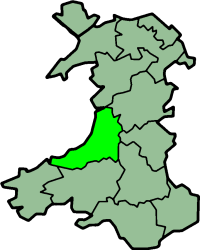
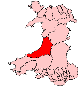
Ceredigion is a coastal county, bordered by Cardigan Bay to the west, Gwynedd to the north, Powys to the east, Carmarthenshire to the south and Pembrokeshire to the south-west. Its area is 1,795 square kilometres (693sqmi).[17] In 2010 the population was 76,938, making it the second most sparsely populated county in Wales.[17]
The Cambrian Mountains cover much of the east of the county; this large area forms part of the desert of Wales. In the south and west, the surface is less elevated. The highest point is Plynlimon (Pumlumon) at 2,467 feet (752m), other Marilyns include Pen y Garn and Llan Ddu Fawr. On the slopes of Pumlumon five rivers have their sources: the Severn, the Wye, the Dulas, the Llyfnant and the Rheidol, the last of which meets the Afon Mynach in a 300 feet (91m) plunge at the Devil's Bridge chasm. The largest river is the River Teifi which forms the border with Carmarthenshire and Pembrokeshire for part of its length. The towns of Lampeter, Llandysul, Newcastle Emlyn and Cardigan are all in the Teifi Valley, and each has communities on each side of the river, in different counties. Other significant rivers include the River Aeron which has its estuary at Aberaeron, and the River Ystwyth and the River Rheidol both of which reach the sea in Aberystwyth harbour.[18]
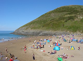
Ceredigion's 50 miles (80km) of coastline has sandy beaches. In 2011 Ceredigion's beaches were awarded five Blue Flag Awards, four Green Coast Awards, and fourteen Seaside Awards.[19] Ceredigion is one of only two places in the United Kingdom with a permanent presence of bottlenose dolphins.[20] Another member of the fauna is the red kite; these may be seen in various localities in the county, but at the Red Kite Feeding Centre near Tregaron, they are fed each day, and large numbers congregate along with hungry crows and other birds.[21]
Between 1991 and 2003 Ceredigion had the largest population growth of any county in Wales, with a 19.5% increase.[22] Tourism and agriculture, chiefly hill farming, are the most important industries. In addition, two universities are within the county boundaries: Aberystwyth University and the Lampeter campus of the University of Wales, Trinity Saint David. The Welsh Plant Breeding Station is near Aberystwyth and linked to the University. The National Library of Wales, founded in 1907, is also in Aberystwyth. Ceredigion is an extremely rural county; the largest town, Aberystwyth, has fewer than 15,000 permanent residents and the remainder of the population of the county is scattered over 150 small towns, villages and hamlets.[23] According to the 2011 UK census the population of Ceredigion was around 75,900. By the time the 2021 UK census was taken this had fallen by 5.8% to 71,500.
The county has no large commercial areas. The nearest substantial settlements are located at least 1 hour 45 minutes drive away. Approximate road distances from Ceredigion's largest town, Aberystwyth, are: Swansea, 75 miles (121km) to the south; Shrewsbury, 76 miles (122km) to the east, in the English county of Shropshire; and Wrexham, 82 miles (132km) to the northeast. The capital, Cardiff, is over 100 miles (160km) from most parts of the county. Although Ceredigion and Gwynedd share a boundary, it is not possible to travel directly between the two by land as all road and rail links avoid the Dyfi estuary and pass through Dyfi Junction or Machynlleth in Powys.[18]
Between 1889 and 1974, the county was governed by Cardiganshire County Council, which took over the local government functions of the quarter sessions.[13] The county council was abolished in 1974 by the Local Government Act 1972, with the area becoming the lower-tier district of Ceredigion within the larger county of Dyfed.[24] Until 1974, Cardiganshire had been governed locally by civil parishes; these in large part equated to ecclesiastical parishes, most of which still exist as part of the Church in Wales.[25] Further local government reform under the Local Government (Wales) Act 1994 saw the area become a unitary authority on 1 April 1996. The 1994 act specified that the reformed council was to have both a Welsh and an English name: Sir Aberteifi / Cardiganshire. Before the new arrangements came into force the incoming council resolved to change the name to Ceredigion in both languages. The government agreed the change of name, which took effect on 2 April 1996, one day after the new authority formally came into being.[26][27][12]
A referendum was held on 20 May 2004 on whether to have a directly elected mayor for the county, which would have been the first in Wales. The Llais Ceredigion political initiative had been formed with this aim,[28] but the proposal was rejected.[29]
As of 2024, the council leader is Bryan Davies of Plaid Cymru.[30]
Farming has traditionally been the basis of Cardiganshire's economy, with dairying and stock-rearing being the main occupations. Before the first railway was built in 1866, the stock used to be herded over the mountains to England, where Rugby, Northampton and London were important destinations. At one time there was a sizeable mining industry in Cardiganshire, but the reserves of lead, silver and zinc became unprofitable to mine by the early 20th century. Shipping was also important in the county, with coal and lime being imported in coastal vessels, and mineral ores and oak bark for tanning being exported. Shipbuilding was an important industry: most of Wales' sailing vessels were built in Cardiganshire.[17]
Cardiganshire had a substantial population in the early modern period, but this declined during the 19th century as wider social and economic developments affected all aspects of Cardiganshire life. Traditional industries were in decline, agriculture was in decline and it was becoming increasingly difficult for a still-rising population to earn a living within their native parishes and communities. By the first half of the 20th century, falling livestock prices and greater international competition made farming unprofitable. Many residents of Cardiganshire moved to other parts of South Wales, where there were better employment opportunities, and many more emigrated to the United States, Canada, Patagonia and Australia.[17] Furthermore, the owners of the great landed estates, who had for so long dominated the politics of the county, were in many cases heavily in debt. This led to the loss of landowner influence in the running of the county; this became very apparent at the first elections to the Cardiganshire County Council in 1889.[35]
By the second half of the 20th century, the population was increasing again. More retired people were arriving to make their home in the tranquil surroundings, and after the Beacham Commission in the 1960s, the British government realised that the rural way of life in parts of Wales was in crisis, and started to react. Through government initiatives and local actions, opportunities in tourism, rural crafts, specialist food shops, farmers' markets and added-value food products began to emerge.[17] However, in 2011, at 3.1%, Ceredigion still had one of the highest proportions of its population working in agriculture, forestry and fishing, close behind such other places as Orkney and Shetland.[36] Exposed, marginal land is also used for wind farms: Cefn Croes Wind Farm near Devil's Bridge has 39 turbines and a nominal capacity of 58.5MW.[37]
Farm incomes have been in decline over the years; and, as well as being a European Objective I area, in 2001 Ceredigion was designated a regional "Tourist growth area" by the Wales Tourist Board.[23] There is little industry other than farming, so tourism plays an important part in the county's economy. Visitors stay in hotels, guest houses and homes offering bed-and-breakfast, self-catering cottages, caravans and camp sites; they spend money in local shops, dine in local establishments and visit the county's many attractions. Ceredigion prides itself on offering an unspoilt natural landscape, and Aberystwyth claims to be the capital of Welsh culture.[38]
Leisure activities available in the county include beach activities, rambling, cycling, sea fishing, canoeing, sailing and horse riding. Many of the towns and villages along the coast have small harbours and facilities for sailing, dolphin watching and other maritime activities. The Ceredigion Coast Path from Cardigan to Ynyslas runs about 60 miles (97km) along the coast with spectacular scenery. It can conveniently be divided into seven sections.[46] When Dylan Thomas lived in New Quay and Talsarn, he frequented Aberaeron and Lampeter. The Dylan Thomas Trail links places associated with him.[47]
The Welsh Government's Visit Wales website describes the River Teifi as "one of the major game rivers of Wales,"[48] although there has been concern that salmon stocks are in decline.[49] There are a series of rapids near Llandysul where canoeing, kayaking and white water rafting take place.[50]
The county's main football team, Aberystwyth Town in the Cymru Premier, play their home matches at Park Avenue Stadium.[51] Cardigan Town Football Club, also known as the "Magpies", play in Division 1 of the Ceredigion League.[52]
There are local bus services between the main centres of population,[55] with long distance services between Aberystwyth and Cardiff, via Aberaeron and Lampeter. A bus service known as Bwcabus operates in the south of the county, offering customised transport for rural dwellers.[56] TrawsCymru T1 service runs between Aberystwyth and Carmarthen, with some journeys through Aberaeron and Lampeter.
Aberporth Airport, located south-east of Aberporth, is being developed as West Wales Airport for domestic flights within Wales and the rest of the United Kingdom. The airport is also developing as a centre for the deployment of civil and military unmanned aerial vehicles (UAVs), also known as 'drones'. The airport underwent major improvements in 2008, which extended the length of the runway from 945 to 1,257m (3,100 to 4,124ft).[55][57]
Dyfed is a preserved county in southwestern Wales. It is a mostly rural area with a coastline on the Irish Sea and the Bristol Channel.
Carmarthenshire is a county in the south-west of Wales. The three largest towns are Llanelli, Carmarthen and Ammanford. Carmarthen is the county town and administrative centre. The county is known as the "Garden of Wales" and is also home to the National Botanic Garden of Wales.
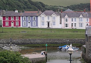
Aberaeron, previously anglicised as Aberayron, is a town, community and electoral ward in Ceredigion, Wales. Located on the coast between Aberystwyth and Cardigan, its resident population was 1,274 in the 2021 census.
Cardigan is a town and community in the county of Ceredigion, Wales. Positioned on the tidal reach of the River Teifi at the point where Ceredigion meets Pembrokeshire, Cardigan was the county town of the historic county of Cardiganshire. Cardigan is the second-largest town in Ceredigion. The largest town, Aberystwyth, is one of the two administrative centres; the other is Aberaeron.
Lampeter is a town, community and electoral ward in Ceredigion, Wales, at the confluence of the Afon Dulas with the River Teifi. It is the third largest urban area in Ceredigion, after Aberystwyth and Cardigan, and has a campus of the University of Wales Trinity Saint David. At the 2011 Census, the population was 2,970. Lampeter is the smallest university town in the United Kingdom. The university adds approximately 1,000 people to the town's population during term time.
Cardigan Bay is a large inlet of the Irish Sea, indenting the west coast of Wales between Bardsey Island, Gwynedd in the north, and Strumble Head, Pembrokeshire at its southern end. It is the largest bay in Wales.
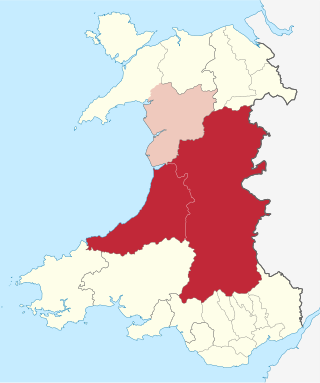
Mid Wales, or Central Wales, is a region of Wales, encompassing its midlands, in-between North Wales and South Wales. The Mid Wales Regional Committee of the Senedd covered the unitary authority areas of Ceredigion and Powys and the area of Gwynedd that had previously been the district of Meirionnydd. A similar definition is used by the BBC. The Wales Spatial Plan defines a region known as "Central Wales" which covers Ceredigion and Powys.
The River Teifi in Wales forms the boundary for most of its length between the counties of Ceredigion and Carmarthenshire, and for the final 3 miles (4.8 km) of its total length of 76 miles (122 km), the boundary between Ceredigion and Pembrokeshire. Its estuary is northwest of Cardigan, known in Welsh as Aberteifi, meaning 'mouth of the Teifi'. Teifi has formerly been anglicised as "Tivy".
Ceredigion was a parliamentary constituency represented in the House of Commons of the UK Parliament. Created in 1536, the franchise expanded in the late 19th century and on the enfranchisement of women. Its boundaries remained virtually unchanged until 1983. From 1536 until 1885 the area had two seats : a county constituency (Cardiganshire) comprising the rural areas, the other the borough constituency known as the Cardigan District of Boroughs comprising a few separate towns; in 1885 the latter was abolished, its towns and electors incorporated into the former, reduced to one MP. The towns which comprised the Boroughs varied slightly over this long period, but primarily consisted of Cardigan, Aberystwyth, Lampeter and Adpar, the latter now a suburb of Newcastle Emlyn across the Teifi, in Carmarthenshire.
Penparcau is a village and electoral ward in Ceredigion, Wales, situated to the south of Aberystwyth.
David James Jones, commonly known by his bardic name Gwenallt, was a Welsh poet, critic, and scholar, and one of the most important figures of 20th-century Welsh-language literature. He created his bardic name by transposing Alltwen, the name of the village across the river from his birthplace.
Ceredigion County Council is the governing body for the county of Ceredigion, since 1996 one of the unitary authorities of Wales. The council's main offices are in Aberaeron.
The Carmarthen–Aberystwyth line was originally a standard-gauge branch line of the Great Western Railway (GWR) in Wales, connecting Carmarthen and Aberystwyth.
The Ceredigion Coast Path is a waymarked long distance footpath in the United Kingdom, on the coast of Ceredigion, Wales. It is 65 miles (105 km) in length, running along the coast of Cardigan Bay from Cardigan (52.0810°N 4.6608°W) to Ynyslas (52.5271°N 4.0495°W).
Cardiganshire County Council was the local government authority for the county of Cardiganshire, Wales, between 1889 and 1974. It was superseded by Dyfed County Council.
Aberystwyth is a university and seaside town and a community in Ceredigion, Wales. It is the largest town in Ceredigion and 16 miles (26 km) from Aberaeron, the county's other administrative centre. In 2021, the population of the town was 14,640.
The Ceredigion League is a Welsh football league for the county of Ceredigion. It is at the fifth to seventh levels of the Welsh football league system. It was founded in 1921 as the Cardiganshire League in Lampeter. The ten founding teams were Aberaeron, Aberystwyth Battery, Conservative FC, College Reserves, Drefach, Lampeter, Llanybydder, Newcastle Emlyn, Padarn United and Parish Hall United. Newcastle Emlyn withdrew from the league without playing games.
Ceredigion District Council was one of six district-level authorities in the county of Dyfed, Wales, from 1974 until 1996. The district had an identical area to the pre-1974 administrative county of Cardiganshire. From its creation in 1974 the district used the name "Ceredigion" rather than "Cardiganshire", which had been used for the former county council. Further local government reorganisation in 1996 saw Dyfed County Council abolished and Ceredigion become a unitary authority, with the district council taking over county-level services to become Ceredigion County Council.
The bedrock geology of Ceredigion in west Wales consists wholly of a considerable thickness of Ordovician and Silurian age sedimentary rocks of marine origin. Unconsolidated deposits of Quaternary age include a widespread cover of glacial till, valley floor alluvium and scattered peat deposits in both upland and lowland settings.
The 2022 Ceredigion County Council election took place as of 5 May 2022 to elect 38 members to Ceredigion Council. On the same day, elections were held to the other 21 local authorities and to community councils in Wales as part of the 2022 Welsh local elections. The previous all-council election took place in May 2017 and future elections will take place every five years.
References
↑ "Your Council". Ceredigion County Council. Retrieved 6 August 2024.
↑ Morgan, K. O. (1967). "Cardiganshire politics: the Liberal ascendancy, 1885–1923". Journal of the Cardiganshire Antiquarian Society. 5 (4): 314–18, 319–20. S2CID157863376.
This page is based on this Wikipedia article Text is available under the CC BY-SA 4.0 license; additional terms may apply. Images, videos and audio are available under their respective licenses.