Rhydypennau, Ceredigion

Last updated

Rhydypennau
Rhydypennau - 2008-03-01.jpg
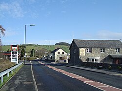
Rhydypennau, taken from Rhiw Baker looking north towards Tal-y-bont
Ceredigion UK location map.svg
Red pog.svg
Rhydypennau
Location within Ceredigion
Population2,258  [1]
Language British English
Welsh
OS grid reference SN6285
Principal area
Ceremonial county
Country Wales
Sovereign state United Kingdom
Post town BOW STREET
Postcode district SY24
Dialling code 01970
Police Dyfed-Powys
Fire Mid and West Wales
Ambulance Welsh
UK Parliament
List of places
UK
Wales
Ceredigion
52°27′14″N4°01′11″W / 52.453889°N 4.019722°W / 52.453889; -4.019722 Coordinates: 52°27′14″N4°01′11″W / 52.453889°N 4.019722°W / 52.453889; -4.019722

Rhydypennau is a hamlet in the Genau'r-glyn district of Ceredigion, Wales, approximately 4+12 miles (7.2 km) north-east of Aberystwyth. [2] Along with the village of Pen-y-garn, Rhydypennau is now often considered to be part of the neighbouring village of Bow Street. All three places stretch in a long narrow strip along the main Aberystwyth to Machynlleth road (A487).

Contents

Toponymy

In his memoirs about growing up in Llanfihangel Geneu’r Glyn (Llandre), Pen-y-garn and Bow Street, Tom Macdonald (1900–80) recalls that the local pronunciation of Rhydypennau was ‘Rhypenne’. [3]

Archaeology

An early Bronze-age copper thin-butted flat axe was found to the north-east of Rhydypennau Bridge. The axe has one smooth face, which is slightly hammered along its edges, whilst the other is irregular and shows traces of tooling. [4]

Services

Rhyd-y-Pennau Inn Tafarn Rhydypennau.jpg
Rhyd-y-Pennau Inn

Rhydypennau is centred on the junction of the A487 with the road towards Llandre and Borth. As well as a few houses, there is the Rhyd-y-Pennau Inn, Rhydypennau Garage, the Pennau craft centre, and Rhydypennau Farm.

The old Rhydypennau School (which was closed in the late 1990s) overlooks the hamlet, whilst the present Rhydypennau school, Ysgol Rhydypennau, is located in Pen-y-garn. Bow Street Football Club's ground, Cae Piod, is also at Rhydypennau.

Notable residents

Related Research Articles

<span class="mw-page-title-main">Ceredigion</span> County in Wales

Ceredigion is a county in the west of Wales, corresponding to the historic county of Cardiganshire. During the second half of the first millennium Ceredigion was a minor kingdom. It has been administered as a county since 1282. Ceredigion is considered a centre of Welsh culture and just under half of the population can speak Welsh according to the 2011 Census. The county is mainly rural, with over 50 miles (80 km) of coastline and a mountainous hinterland. The numerous sandy beaches and the long-distance Ceredigion Coast Path provide views of Cardigan Bay.

<span class="mw-page-title-main">Borth</span> Seaside village in Wales

Borth is a village and seaside resort in Ceredigion, Mid Wales, 7 miles (11 km) north of Aberystwyth on the Ceredigion Coast Path. The community includes the settlement of Ynyslas. The population was 1,399 in 2011. From being largely Welsh-speaking, the village has become anglicised: over 54 per cent of its residents were born in England. According to both the 1991 and 2001 censuses, 43 per cent of the residents of Borth were primarily Welsh-speakers.

<span class="mw-page-title-main">T. Ifor Rees</span>

Dr Thomas Ifor Rees CMG was a British diplomat, author and translator. Born Thomas Ifor Rees at 'Bronceiro' near the hamlet of Rhydypennau in Cardiganshire, Wales, he served as Britain's first Ambassador to Bolivia from 1947 until his retirement in 1949.

<span class="mw-page-title-main">Penygroes, Gwynedd</span> Human settlement in Wales

Penygroes is a village in Gwynedd, Wales. The village is located to the south of Caernarfon, and north of Porthmadog, by the A487 road. Penygroes' population stands at 1,793 at the 2011 census, of which 88% are Welsh-speaking, making it one of the most predominantly Welsh-speaking areas of the country. The population of Llanllyfni community, which includes Penygroes and Llanllyfni village, which practically adjoins Penygroes, plus Talysarn, is 4,135 according to the 2011 census.

<span class="mw-page-title-main">Llandre</span> Village in Ceredigion, Wales

Llandre, or Llanfihangel Genau'r Glyn, is a village in Ceredigion, Wales. It lies 5 miles north of Aberystwyth in the north-west of the county, on the road from Rhydypennau to Borth. To the north of the community lies the village of Dôl-y-bont. The community is called Geneu'r Glyn.

<span class="mw-page-title-main">Bow Street, Ceredigion</span> Human settlement in Wales

Bow Street is a large village in the Tirymynach district of Ceredigion, Wales, approximately 3.5 miles (5.6 km) north-east of Aberystwyth. As well as Bow Street itself, it is now often considered to include the neighbouring smaller village of Pen-y-garn and the hamlet of Rhydypennau. All three places stretch in a long narrow strip along the main Aberystwyth to Machynlleth road, the A487.

Llanfihangel can refer to the following places in Wales:

<span class="mw-page-title-main">Pen-y-garn, Ceredigion</span> Human settlement in Wales

Pen-y-garn is a small village in the Tirymynach district of Ceredigion, Wales, approximately 4 miles (6 km) north-east of Aberystwyth. Along with the hamlet of Rhydypennau, Pen-y-garn is now often considered to be part of the neighbouring larger village of Bow Street. All three places stretch in a long narrow strip along the main Aberystwyth to Machynlleth road (A487). As well as the houses on the main road from Cross Street up to Ysgol Rhydypennau, Pen-y-garn also includes the housing estates of Maes Ceiro, Bryn Meillion, Maes y Garn and Cae'r Odyn.

<span class="mw-page-title-main">Tom Macdonald (writer)</span> Welsh journalist and novelist

Tom Macdonald (1900–1980) was a Welsh journalist and novelist, whose most significant publication was his highly evocative account of growing up in the north of Cardiganshire in the years before the Great War, which was published in 1975 as The White Lanes of Summer.

<span class="mw-page-title-main">Dewi Morgan</span>

Dewi Morgan, also known by his bardic name "Dewi Teifi", was a Welsh bard, scholar and journalist, who won the Chair at the 1925 National Eisteddfod of Wales in Pwllheli with his important awdl recounting the legend of Cantre'r Gwaelod.

Henllys could refer to a number of places in Wales.

<span class="mw-page-title-main">Rhydwyn</span> Village in Anglesey, Wales

Rhydwyn is a village in the community of Cylch-y-Garn, in the north west of Anglesey, Wales. Rhydwyn is named after a little stream crossing the centre of the village; "Rhyd" means ford and "Wyn" White.

<span class="mw-page-title-main">Castell Gwallter</span>

Castell Gwallter, also known as Walter's Castle and sometimes Castell Penweddig, is the remains of a Norman motte-and-bailey castle situated on a large hill above the old village of Llandre in northern Ceredigion, Wales, four miles northeast of Aberystwyth.

<span class="mw-page-title-main">Bow Street railway station</span> Railway station in Ceredigion, Wales

Bow Street is a railway station on the Cambrian Line, which runs between Shrewsbury and Aberystwyth or Pwllheli. The station, situated 4 miles 30 chains (7 km) north-east of Aberystwyth, serves the villages of Bow Street and Pen-y-garn in Ceredigion, Wales. It is owned by Network Rail and managed by Transport for Wales.

<span class="mw-page-title-main">Cwmsymlog</span>

Cwmsymlog is a short valley, sheltering a hamlet of the same name, in Ceredigion, in the west of Wales. Once an important mining area, but the mining slowly declined and finally came to an end in 1901. Now it is peaceful, open countryside with a few mining remains, scattered houses and farmland. It is also the name of a Site of Special Scientific Interest at that location.

<span class="mw-page-title-main">Tirymynach</span> Human settlement in Wales

Tirymynach is a community in Ceredigion, Wales, also an electoral ward, which lies immediately to the north of Aberystwyth.

<span class="mw-page-title-main">Fishguard and Goodwick</span> Human settlement in Wales

Fishguard and Goodwick is the name of a community that wraps around Fishguard Bay, on the northern coast of Pembrokeshire, Wales. It comprises the two towns of Fishguard and Goodwick, with their neighbourhoods of Dyffryn, Harbour Village, Penyraber, Lower Town, and Stop-and-Call. Within the community are two railway stations and Goodwick Ferry Terminal, which is the terminus of the A40 London to Fishguard Trunk Road.

<span class="mw-page-title-main">Trefeurig</span> Human settlement in Wales

Trefeurig is a community in Mid and West Wales, situated around 4 miles (6.4 km) north-east of Aberystwyth. It is a site of particular prehistoric, Roman, and Iron Age interest, and has a long history as a mining area. In 2011 the local population was estimated at around 1,771 people.

The bedrock geology of Ceredigion in west Wales consists wholly of a considerable thickness of Ordovician and Silurian age sedimentary rocks of marine origin. Unconsolidated deposits of Quaternary age include a widespread cover of glacial till, valley floor alluvium and scattered peat deposits in both upland and lowland settings.

References

  1. Total population of Genau’r Glyn (Borth) ( "Census, 2001".)
  2. Davies, Elwyn, Rhestr o Enwau Lleoedd/A Gazetteer of Welsh Place-Names (Gwasg Prifysgol Cymru/University of Wales Press, Caerdydd/Cardiff, 1958), p. 104
  3. Macdonald, Tom, (1975) The White Lanes of Summer, p. 21. London: Macmillan, ISBN   0-333-17975-7
  4. Cardiganshire County History, Vol 1 (1994), p. 217; Sambrook, Paul & Hall, Jenny, Arolwg Cymunedol Llandre Community Audit, p. 33; National Monuments Record of Wales NPRN No. 405446