
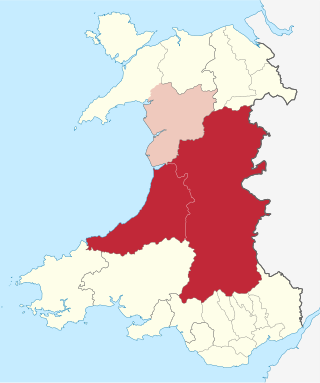
Ceredigion, historically Cardiganshire, is a county in the west of Wales. It borders Gwynedd across the Dyfi estuary to the north, Powys to the east, Carmarthenshire and Pembrokeshire to the south, and the Irish Sea to the west. Aberystwyth is the largest settlement and, together with Aberaeron, is an administrative centre of Ceredigion County Council.

Newcastle Emlyn is a town on the River Teifi, straddling the counties of Ceredigion and Carmarthenshire in West Wales. It is also a community entirely within Carmarthenshire, bordered by those of Llangeler and Cenarth, also in Carmarthenshire, and by Llandyfriog in Ceredigion. Adpar is the part of town on the Ceredigion side of the River Teifi. It was formerly called Trefhedyn and was an ancient Welsh borough in its own right. The area including Adpar had a population of 1,883 according to the 2011 census.
Mid Wales or Central Wales is a region of Wales, encompassing its midlands, in-between North Wales and South Wales. The Mid Wales Regional Committee of the Senedd covered the unitary authority areas of Ceredigion and Powys and the area of Gwynedd that had previously been the district of Meirionnydd. A similar definition is used by the BBC. The Wales Spatial Plan defines a region known as "Central Wales" which covers Ceredigion and Powys.

The River Teifi in Wales forms the boundary for most of its length between the counties of Ceredigion and Carmarthenshire, and for the final 3 miles (4.8 km) of its total length of 76 miles (122 km), the boundary between Ceredigion and Pembrokeshire. Its estuary is northwest of Cardigan, known in Welsh as Aberteifi, meaning 'mouth of the Teifi'. Teifi has formerly been anglicised as "Tivy".

The A482 road is in Ceredigion and Carmarthenshire, Wales. It links Aberaeron at the junction with the A487 road with the A40 road at Llanwrda near Llandovery. It is 29 miles (47 km) long.

Llandysul, also spelt Llandyssul, is a small town and community in the county of Ceredigion, Wales. As a community it consists of the townships of Capel Dewi, Horeb, Pontsian, Pren-gwyn, Tregroes, Rhydowen and the village of Llandysul itself. Llandysul lies in south Ceredigion in the valley of the River Teifi and is visited for its fishing and canoeing. The community had a population of 2732, as of 2011. The village itself has a population of 1484.

The Teifi Valley Railway is a 2 ft narrow gauge railway occupying a section of the former standard gauge Great Western Railway line between Llandysul and Newcastle Emlyn. After the closure of the former line by British Rail in 1973, a preservation group built and periodically extended a narrow-gauge railway along the route, westwards from Henllan, eventually operating a 3 kilometres (1.9 mi) long line as a tourist attraction.

The A475 road in Wales links Newcastle Emlyn in Carmarthenshire with Lampeter in Ceredigion; a distance of 19 miles (31 km).
Newcastle Emlyn was a railway station terminus in the town of Newcastle Emlyn, West Wales, on the proposed broad gauge Teifi Valley line of the Carmarthen and Cardigan Railway.

Emlyn was one of the seven cantrefi of Dyfed, an ancient district of Wales, which became part of Deheubarth in around 950. It consisted of the northern part of Dyfed bordering on the River Teifi. Its southern boundary followed the ridge of the line of hills separating the Teifi valley from the valleys of the Tâf and Tywi.

Llangeler is a hamlet and community located in north Carmarthenshire, Wales. The name is believed to refer to St. Gelert. Llangeler parish covers a wide area including to the west, the textile village of Drefach Felindre, Waungilwen, Cwmpengraig and to the east, Pont Tyweli which adjoins Llandysul on the Carmarthenshire side of the River Teifi. The population of the parish was 3,222 at the Census of 2001, increasing to 3,427 at the 2011 census.
Pentrecwrt is a village in north Carmarthenshire, Wales on the A486 road halfway between Carmarthen and New Quay.

The A486 is an A road in Wales linking New Quay, Ceredigion, with the A484 in Saron (Llangeler), Carmarthenshire.
The Ceredigion League is a Welsh football league for the county of Ceredigion. It is at the fifth to seventh levels of the Welsh football league system. It was founded in 1921 as the Cardiganshire League in Lampeter. The ten founding teams were Aberaeron, Aberystwyth Battery, Conservative FC, College Reserves, Drefach, Lampeter, Llanybydder, Newcastle Emlyn, Padarn United and Parish Hall United. Newcastle Emlyn withdrew from the league without playing games.

Ffostrasol is a small village in the south of Ceredigion, Wales. It is located on the A486 between Synod Inn and Llandysul, and it forms part of the parish of Troedyraur. The village lies on a rural crossroad connecting it with the nearby village of Plwmp to the north, Synod Inn to the north east, Newcastle Emlyn to the south west, and Llandysul to the south east.
Ysgol Dyffryn Teifi was a bilingual comprehensive school in Llandysul, Ceredigion. It stood on the site of the previous Llandysul Grammar School. The school was established in 1984 following the re-organisation of education in the Teifi Valley. It was formerly a county school and grammar school dating back to the 19th century.

Henllan is a village in Ceredigion, Wales.
J. Emrys Morgan Cup is an association football knockout cup competition for football clubs in the lower leagues of the Welsh Football Association pyramid in the Mid and West Wales regions. It consists of a round by round knockout with semi-finals and the final played a neutral ground. Teams are drawn to play each other home or away in rounds up to the semi-finals. The following leagues are covered by the cup:
Ysgol Gyfun Emlyn is a mixed, community comprehensive school in Newcastle Emlyn, Carmarthenshire, Wales. It has around 520 pupils, catering for all abilities across an age range of 11 to 19 years.
