
Ceredigion, historically Cardiganshire, is a county in the west of Wales. It borders Gwynedd across the Dyfi estuary to the north, Powys to the east, Carmarthenshire and Pembrokeshire to the south, and the Irish Sea to the west. Aberystwyth is the largest settlement and, together with Aberaeron, is an administrative centre of Ceredigion County Council.

Lampeter is a town, community and electoral ward in Ceredigion, Wales, at the confluence of the Afon Dulas with the River Teifi. It is the third largest urban area in Ceredigion, after Aberystwyth and Cardigan, and has a campus of the University of Wales Trinity Saint David. At the 2011 Census, the population was 2,970. Lampeter is the smallest university town in the United Kingdom. The university adds approximately 1,000 people to the town's population during term time.

Cardigan Bay is a large inlet of the Irish Sea, indenting the west coast of Wales between Bardsey Island, Gwynedd in the north, and Strumble Head, Pembrokeshire at its southern end. It is the largest bay in Wales.

Cilgerran is both a village, a parish, and also a community, situated on the south bank of the River Teifi in Pembrokeshire, Wales. It was formerly an incorporated market town.

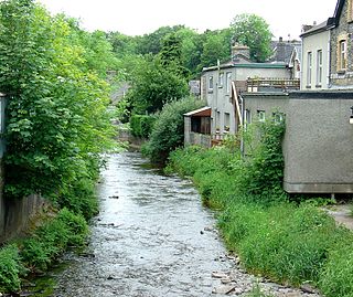
The River Teifi in Wales forms the boundary for most of its length between the counties of Ceredigion and Carmarthenshire, and for the final 3 miles (4.8 km) of its total length of 76 miles (122 km), the boundary between Ceredigion and Pembrokeshire. Its estuary is northwest of Cardigan, known in Welsh as Aberteifi, meaning 'mouth of the Teifi'. Teifi has formerly been anglicised as "Tivy".

The A482 road is in Ceredigion and Carmarthenshire, Wales. It links Aberaeron at the junction with the A487 road with the A40 road at Llanwrda near Llandovery. It is 29 miles (47 km) long.
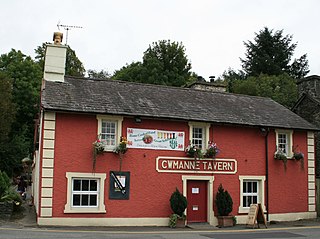
Cwmann is a small village in Carmarthenshire, Wales, in the community of Pencarreg. It is just on the border with Ceredigion and near Lampeter, with Cwmann being on the Carmarthenshire side of the border. The population in 2011 was around 872.
Llanfihangel-ar-Arth is a village and community in the county of Carmarthenshire, Wales.
The Carmarthen–Aberystwyth line was originally a standard-gauge branch line of the Great Western Railway (GWR) in Wales, connecting Carmarthen and Aberystwyth.

The A475 road in Wales links Newcastle Emlyn in Carmarthenshire with Lampeter in Ceredigion; a distance of 19 miles (31 km).

Afon Cych is a tributary of the River Teifi in south-west Wales. It is 13 km long, passes through a number of small settlements on the border between Pembrokeshire and Carmarthenshire, and is significant in Welsh legend.

The Afon Dulas, or North Dulas, is a river forming the border between Merionethshire/Gwynedd and Montgomeryshire/Powys in Wales. Another river called Afon Dulas joins the Dyfi from the south, upstream of its confluence with the North Dulas: locally this is referred to as the South Dulas.
The River Brenig is a tributary river of the River Teifi and runs through the market town of Tregaron in Ceredigion, Wales.

The Ystwyth Trail is a 21-mile (34 km) multi-use rail trail linking Aberystwyth, Llanfarian, Ystrad Meurig and Tregaron in Ceredigion, Wales. Cycling and walking are permitted along the entire length while horseriding is permitted on several sections only.
Lampeter railway station, on the Carmarthen to Aberystwyth Line in Wales, was built to serve the town of Lampeter. It opened in 1866, six years after the line, which reached Aberystwyth in August 1867.
Ysgol Dyffryn Teifi was a bilingual comprehensive school in Llandysul, Ceredigion. It stood on the site of the previous Llandysul Grammar School. The school was established in 1984 following the re-organisation of education in the Teifi Valley. It was formerly a county school and grammar school dating back to the 19th century.
The Afon Llynfi is a short river in the county of Powys, south Wales. A tributary of the River Wye, it runs approximately south to north just to the west of the Black Mountains and partly within the Brecon Beacons National Park.
Silian, originally Sulien, is a village in the valley of the River Teifi, Ceredigion, Wales. It is located approximately two miles north-west of Lampeter, on a minor road connecting Pont Creuddun on the A482, and Glan Denys on the A485.

Llangybi is a village and parish in the south of Ceredigion, Wales. It is located on the A485 between Tregaron to the north and Lampeter to the south, a mile and a half north of the village of Betws Bledrws, which is in the wider community. Silian is another village located within the community.

Betws Bledrws, is a village between Lampeter and Llangybi, Ceredigion, Wales that was also known as Derry Ormond when under the influence of Derry Ormond Mansion. Situated on the valley floor of the River Dulas, approximately 3 miles (4.8 km) north of Lampeter and a mile or so to the southwest of the village of Llangybi, on the road from Tregaron to Lampeter.

