
Ramsey Island is an island about 1 kilometre off St David's Head in Pembrokeshire on the northern side of St Brides Bay, in southwest Wales, in the community of St Davids and the Cathedral Close. It is 259 hectares in area. Ramsey means Hrafn's island.
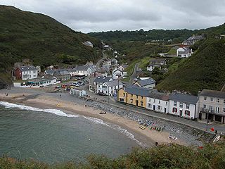
Llangrannog is both a village and a community in Ceredigion, Wales, 6 miles (10 km) southwest of New Quay. It lies in the narrow valley of the River Hawen, which falls as a waterfall near the middle of the village. Llangrannog is on the Wales Coast Path.

Ynys Llanddwyn is a small tidal island off the west coast of Anglesey, northwest Wales. The nearest settlement is the village of Newborough.
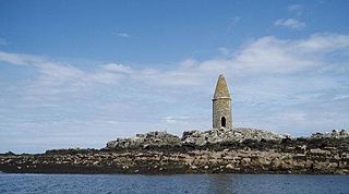
Ynys Bery is a small island south of Ramsey Island, Pembrokeshire, Wales, in the community of St David's and the Cathedral Close.
Ynys Môn is a constituency of the House of Commons of the Parliament of the United Kingdom. It elects one Member of Parliament (MP) by the first past the post system of election.
The Skerries coming from the Old Norse word sker are a group of sparsely vegetated rocky islets (skerries), with a total area of about 17 hectares lying 3 kilometres (1.9 mi) offshore from Carmel Head at the northwest corner of Anglesey, Wales. The islands are important as a breeding site for seabirds, and they attract divers, who come to visit the numerous shipwrecks. The Skerries Lighthouse sits atop the highest point in the islands.
Ynys Feurig is the name for a set of three small inter-connected low-lying inshore tidal rocky islets, lying off from the west coast of Anglesey, North Wales, just north of the village of Rhosneigr and south of RAF Valley airfield. They are also known by the English name Starvation Island. The islets are accessible from the mainland at mid-to low tide. The clipper Norman Court ran aground nearby, in Cymyran Bay.

Puffin Island is an uninhabited island off the eastern tip of Anglesey, Wales. It was formerly known as Priestholm in English and Ynys Lannog in Welsh. A hermitage was established here around the 6th century, and there are remains of a 12th-century monastery on the island. The island is also a Special Protection Area for wildlife.

The Isle of Anglesey County Council is the local authority for the county of Anglesey, one of the principal areas of Wales. Since 2022 the council has 35 councillors who represent 11 multi-member electoral wards.

Alyn and Deeside is a constituency of the Senedd. It elects one Member of the Senedd by the first past the post method of election. Also, however, it is one of nine constituencies in the North Wales electoral region, which elects four additional members, in addition to nine constituency members, to produce a degree of proportional representation for the region as a whole.

The Vale of Clwyd is a constituency of the Senedd. It elects one Member of the Senedd by the first past the post method of election. Also, however, it is one of nine constituencies in the North Wales electoral region, which elects four additional members, in addition to nine constituency members, to produce a degree of proportional representation for the region as a whole.
Ynys Môn is a constituency of the Senedd. It elects one Member of the Senedd by the first past the post method of election. Also, however, it is one of nine constituencies in the North Wales electoral region, which elects four additional members, in addition to nine constituency members, to produce a degree of proportional representation for the region as a whole.
Ynys Dulas is a small island located off the north-east coast of Anglesey, Wales. It marks the most eastern part of the parish of Llaneilian.

Morfa Bychan is a village located in Gwynedd, North Wales, with a population of over 500, with an almost equal number of people born in England or Wales.

Anglesey is an island off the north-west coast of Wales. It forms a principal area known as the Isle of Anglesey, that includes Holy Island across the narrow Cymyran Strait and some islets and skerries. Anglesey island, at 260 square miles (673 km2), is the largest in Wales, the seventh largest in Britain, largest in the Irish Sea and second most populous there after the Isle of Man. Isle of Anglesey County Council administers 276 square miles (715 km2), with a 2011 census population of 69,751, including 13,659 on Holy Island. The Menai Strait to the mainland is spanned by the Menai Suspension Bridge, designed by Thomas Telford in 1826, and the Britannia Bridge, built in 1850 and replaced in 1980. The largest town is Holyhead on Holy Island, whose ferry service with Ireland handles over two million passengers a year. The next largest is Llangefni, the county council seat. From 1974 to 1996 Anglesey was part of Gwynedd. Most full-time residents are habitual Welsh speakers. The Welsh name Ynys Môn is used for the UK Parliament and Senedd constituencies. The postcodes are LL58–LL78. It is also a historic county of Wales.

These are the results of the 2001 United Kingdom general election in Wales. The election was held on 7 June 2001 and all 40 seats in Wales were contested. The overall result remained exactly the same as in the previous election in 1997, with only two changes - Labour gained Ynys Môn from Plaid Cymru and Plaid gained Carmarthen East and Dinefwr from Labour. The Conservatives once again won no seats; this was only the second election since 1918 to leave them with no representation in Wales.

Yny lhyvyr hwnn was the first book to be printed in the Welsh language. It was written by Sir John Price of Brecon, a nobleman and secretary of the Council of Wales and the Marches. He was one of the most important Welsh manuscript collectors of his time, after the dissolution of the monasteries. The publication's main objective was to correct the lack of material, and specifically, the lack of religious material, available in the Welsh language. As Yny lhyvyr hwnn was a humanist venture with the aim to put into print the literary heritage of Wales, Price also included an ABC section and the first Welsh printed alphabet. A record of English, European and Welsh saints was added, as well as a monthly forecast for agricultural purposes. The last section of the pamphlet is a comprehensive religious text, approximating contemporary primer prayer books but sans the canonical hours. These subjects dominated many early Welsh publications. Yny lhyvyr hwnn was printed in London by Edward Whitchurch in 1546.

Virginia Ann Crosbie is a British Conservative Party politician who has been the Member of Parliament (MP) for Ynys Môn since the 2019 general election. Prior to her political career, she worked as a director at UBS and HSBC before retraining as a mathematics teacher.

The 2023 Periodic Review of Westminster constituencies is the current cycle of the process to redraw the constituency map for the House of Commons. The process for periodic reviews of parliamentary constituencies in the United Kingdom is governed by the Parliamentary Constituencies Act 1986, as amended by the Parliamentary Voting System and Constituencies Act 2011 and subsequently by the Parliamentary Constituencies Act 2020. This review is the successor to the 2018 Periodic Review of Westminster constituencies, which was ultimately abandoned after it failed to pass into law.
The bedrock geology of Ceredigion in west Wales consists wholly of a considerable thickness of Ordovician and Silurian age sedimentary rocks of marine origin. Unconsolidated deposits of Quaternary age include a widespread cover of glacial till, valley floor alluvium and scattered peat deposits in both upland and lowland settings.

