
Oakford (Welsh : Derwen-gam) is a hamlet in the county of Ceredigion, Wales.
It is some 5 miles (8 km) south of the coastal town of Aberaeron.
Oakford (Welsh : Derwen-gam) is a hamlet in the county of Ceredigion, Wales.
It is some 5 miles (8 km) south of the coastal town of Aberaeron.
52°11′54″N4°16′04″W / 52.19841°N 4.26789°W
| | This Ceredigion location article is a stub. You can help Wikipedia by expanding it. |

The Arctic Archipelago, also known as the Canadian Arctic Archipelago, is an archipelago lying to the north of the Canadian continental mainland, excluding Greenland and Iceland.
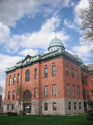
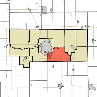
Menard County is a county in the U.S. state of Illinois. According to the 2020 United States Census, it had a population of 12,297. Its county seat is Petersburg. Menard County is part of the Springfield, Illinois, IL Metropolitan Statistical Area.

Oakford is a village in Menard County, Illinois, United States. The population was 234 at the 2020 census, down from 286 in 2010. It is part of the Springfield, Illinois Metropolitan Statistical Area.
This is a list of the extreme points of the United Kingdom: the points that are farther north, south, east or west than any other location. Traditionally the extent of the island of Great Britain has stretched "from Land's End to John o' Groats".
Arqiva is a British telecommunications company which provides infrastructure, broadcast transmission and smart meter facilities in the United Kingdom. The company is headquartered at the former Independent Broadcasting Authority headquarters in Crawley, Hampshire, England. Its main customers are broadcasters and utility companies, and its main asset is a network of circa. 1,500 radio and television transmission sites. It is owned by a consortium of investors led by Digital 9 Infrastructure and the Australian investment house Macquarie Bank. Arqiva is a patron of the Radio Academy.

European route E22 is one of the longest European routes. It has a length of about 5,320 km (3,310 mi). Many of the E-roads have been extended into Asia since the year 2000; the E22 was extended on 24 June 2002.

Oakford is a village and civil parish in the Mid Devon district of Devon, England. It is located three miles (5 km) south west of Bampton and eight miles (13 km) north north west of Tiverton. Oakford is near the river Exe.

Oakford is an outer suburb of Perth, Western Australia, within the Shire of Serpentine-Jarrahdale. The suburb was named in 1982, taking its name from a townsite briefly declared in the area in 1926.

Oakford No. 9 Precinct is located in Menard County, Illinois. The population was 488 at the 2000 census.

The River Onny is a river in Shropshire, England. It is a major tributary of the River Teme.

Coleg Ceredigion, formerly known as Aberystwyth Technical College and later as Aberystwyth College of Further Education, is a bilingual further education college in Ceredigion, Wales. It has two campuses in the two largest towns in Ceredigion, namely Aberystwyth (52.4104°N 4.0532°W) and Cardigan (52.0872°N 4.6567°W). The Principal is Andrew Cornish.
Taylor Township is one of eleven townships in Howard County, Indiana, United States. As of the 2020 census, its population was 9,396, up from 9,294 in 2010.

The Springfield Metropolitan Statistical Area, as defined by the United States Census Bureau, is an area consisting of two counties in Central Illinois, anchored by the city of Springfield. As of the 2000 census, the MSA had a population of 201,437.

The 1994 U.S. Open Cup was the 81st edition of the soccer tournament to crown the national champion of the United States. This was the last tournament before the reintroduction of professional teams with A-League teams taking part in 1995 and MLS teams in 1996.

The Strathcona neighbourhood is located west of downtown Hamilton, Ontario, and is bounded by Highway 403, the CNR rail line, Queen Street, York Boulevard and Main Street. The neighbourhood is also intersected by several other major street arteries: Dundurn Street, Locke Street, and King Street West. As of the 2016 census, Strathcona has a population of 6,555, up from 5,800 in the 1996 census.

Fairfield Township is a civil township of Lenawee County in the U.S. state of Michigan. As of the 2020 census, the township population was 1,661.

The Glaisnock Water is a tributary of the Lugar Water in East Ayrshire, Scotland. It passes under the Glaisnock Viaduct. The source is located south of the town of Cumnock, through which it flows.
