Bremia (fort)

Last updated

Bremia
The Afon Teifi and Cefn Garth, Ceredigion - geograph.org.uk - 1243023.jpg
Ceredigion UK location map.svg
Red pog.svg
Known also asLlanio Roman Fort
Founded during the reign of Vespasian
Foundedc. 73 - 77 AD
Abandonedc. 125 AD
Place in the Roman world
Province Britannia
Nearby water River Teifi
Stationed military units
Cohorts
II Asturum
Location
Coordinates 52°11′23″N3°59′05″W / 52.1896°N 3.9848°W / 52.1896; -3.9848
Place nameLlanio
Town Llanddewi Brefi
County Ceredigion
CountryWales
Reference
UK-OSNG referenceSN643564
Site notes
Discovery yearLate 17th century
ConditionTraces and crop marks
Controlled by Scheduled Monument (SAM: CD129)

Bremia is the name of the Roman fort in the small dispersed settlement of Llanio, West Wales. It is in Llanddewi Brefi community area, south-west of Tregaron, in Ceredigion. The fort was built by the Romans around AD 75 [1] and was in use to AD 120 in Roman Wales. The fort was situated on Sarn Helen, a Roman road leading north from the fort at Dolaucothi. Five inscribed stones have been found within the fort and surrounding military settlement. Two of these have inscriptions which show the garrison to include to a cohort from the Asturias, northern Spain. [2] Amongst the excavations on the site, is the bathhouse. The bathhouse and fort are scheduled monuments, giving them statutory protection from disturbance. [3]

Contents

Bremia (fort)
Map of Roman forts between Caerleon and west Wales dating to the later 1st century AD. Where the Roman names are known, these were identified through the Ravenna Cosmography [lower-alpha 1] (except for Luentinum and Moridunum which are mentioned in Ptolemy's Geographia).
Blue/black dots are listed in the Cosmography. [4] Grey dots are other substantial forts known through archaeological remains.
1
Isca Augusta (Caerleon)
2
Gobannium, (Abergavenny)
3
Cicutio/Cicucium (Y Gaer, Brecon)
4
Alabum (Llanfair-ar-y-bryn, Llandovery)
5
Luentinum, (Pumsaint)
6
Bremia (Llanio, near Llanddewi Brefi)
7
Roman fort at Trawscoed
8
Roman Fort near Pen-llwyn
9
Dinefwr Park Roman forts, Llandeilo
10
Moridunum (Carmarthen)
11
Castell Collen (Llandrindod Wells)
12
Magnis (Kenchester), Herefordshire

Documentary evidence

The only documentary evidence for the name Bremia is a list of place names of the known world compiled in around 700 AD, known as the Ravenna Cosmography. [1] This places Bremia on the route that runs from Gobannium (Abergavenny) through Alabum (Llandovery) (see map below). The fort at Llanio is assumed to be the location referred to, [5] and the nearby 'Afon Brefi' stream name, running through Llanddewi Brefi supports that. [6]

Archaeological evidence

The archaeological remains at the site were first noted in the 17th century by Edward Lhuyd, at a site he called 'Cae'r Castell'. Coins, bricks and pottery were all found by him. [2] Details of various excavations were published in 1888, 1961, 1969 and 1972. [2] The dry summers of 1975 and 1976 revealed the extent of the defensive banks and ditches, some street patterns and other details, through cropmarks on aerial photographs. [2] The almost square enclosure, with characteristic rounded corners, measures some 130 metres (430 ft) across, and could have garrisoned some 500 soldiers. [2] Further occupation evidence outside the fort suggests a vicus (settlement) grew up to the south of the fort, which may have housed a further 1,000 people. [2] During the late 1960s and early 1970s a number of excavations were made at the site of the bathhouse, which revealed foundation trenches although the building materials had been removed, and no firm dating evidence was found. A gradiometer geophysical survey of 2005, 75m to the west of the fort, plotted the line of a Roman road running east-west, from the fort, through building plots, with evidence of small smelting or burning sites. [7]

Inscribed stones

During excavations, five different inscribed stones have been found. Two of these refer to the cohort of auxiliaries that garrisoned the fort, the other three name different centurions whose men had constructed parts of the fort. The cohort stones read, 'COH II ASTVR ...' ("The Second Cohort of Asturians [...]") and '...MIBVS ...COH II ASTVR', ("[...]mibus [...] the Second Cohort of Asturians"). The centurial stones read, 'ARTI MENNIVS PRIMVS', ("The century of Artius Mennius Primus [made this]"; 'ARTI', ("The century of Artius [made this]"); 'VERIONIS', ("The century of Verionus [made this]"). [5]

See also

Related Research Articles

<span class="mw-page-title-main">Coventina</span>

Coventina was a Romano-British goddess of wells and springs. She is known from multiple inscriptions at one site in Northumberland, England, an area surrounding a wellspring near Carrawburgh on Hadrian's Wall. It is possible that other inscriptions, two from Hispania and one from Narbonensis, refer to Coventina, but this is disputed.

<span class="mw-page-title-main">Llanddewi Brefi</span> Human settlement in Wales

Llanddewi Brefi is a village, parish and community of approximately 500 people in Ceredigion, Wales. The village is notable for the famous Synod of Brefi held here in the sixth century. A number of miraculous events are said to have occurred during the synod, most notably by Saint David Welsh: Dewi Sant, patron saint of Wales. Today, it is one of the largest parishes in Wales and lies 7 miles (11 km) north-east of Lampeter between Tregaron and Llanfair Clydogau.

<i>Ravenna Cosmography</i>

The Ravenna Cosmography is a list of place-names covering the world from India to Ireland, compiled by an anonymous cleric in Ravenna around 700 AD. Textual evidence indicates that the author frequently used maps as his source.

<span class="mw-page-title-main">Arbeia</span> Roman fort in Tyne & Wear, England

Arbeia was a large Roman fort in South Shields, Tyne & Wear, England, now ruined, and which has been partially reconstructed. It was first excavated in the 1870s and all modern buildings on the site were cleared in the 1970s. It is managed by Tyne and Wear Museums as Arbeia Roman Fort and Museum.

<span class="mw-page-title-main">Luentinum</span> Roman fort and mining settlement in Carmarthenshire, Wales

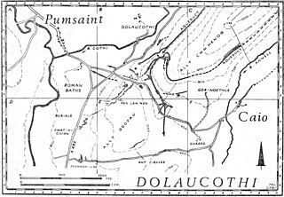
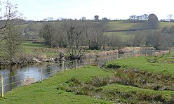
Luentinum or Loventium refers to the Roman fort at Pumsaint, Carmarthenshire. The 1.9 hectares site lies either side of the A482 in Pumsaint and was in use from the mid 70s AD to around 120 AD. It may have had particular functions associated with the adjacent Dolaucothi Gold Mines. It formed part of a network of at least 30 forts across Wales, such as Llandovery, Bremia/Llanio near Llanddewi Brefi, and the fort at Llandeilo. The Roman road Sarn Helen, which runs past the Llanio and Llandovery forts was nearby.

<span class="mw-page-title-main">Carrawburgh</span> Settlement in Northumberland, England

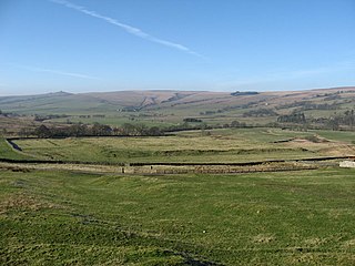
Carrawburgh is a settlement in Northumberland. In Roman times, it was the site of a 3+12-acre (1.5 ha) auxiliary fort on Hadrian's Wall called Brocolitia, Procolita, or Brocolita. This name is probably based on the Celtic name for the place, and one possible translation put forward is 'badger holes'. The fort there was a mile or so west of the Wall's northernmost point at Limestone Corner, and just over a mile west of the nearest milecastle, Milecastle 30. The fort either used the Wall itself as its northern rampart, or was built parallel to it but detached. It certainly postdates both the Wall and the vallum.

<span class="mw-page-title-main">Longovicium</span> Auxiliary Roman fort in Durham county

Longovicium was an auxiliary fort located on Roman Dere Street, in the Roman province of Britannia Inferior. It is located just southwest of Lanchester in the English county of Durham, roughly 8 miles (13 km) to the west of the city of Durham and 5 miles (8 km) from Consett.

<span class="mw-page-title-main">Vindomora</span> Roman auxiliary fort in County Durham, England

Vindomora was an auxiliary fort on Dere Street, in the province of Lower Britain. Its ruins, now known as Ebchester Roman Fort, are situated at Ebchester in the English county of Durham, to the north of Consett and 12 miles (19 km) west-south-west from Newcastle upon Tyne.

<span class="mw-page-title-main">Concangis</span> Roman fort in Duram, England

Concangis was an auxiliary castra in the Roman province of Lower Britain. Its ruins are located in Chester-le-Street, Durham, in England, and are now known as Chester-le-Street Roman Fort. It is situated 6 miles (10 km) north of Durham and 8 miles (13 km) south of Newcastle upon Tyne.

<span class="mw-page-title-main">Aesica</span> Roman fort in Northumberland, England

Aesica was a Roman fort, one and a half miles north of the small town of Haltwhistle in Northumberland, England. It was the ninth fort on Hadrian's Wall, between Vercovicium (Housesteads) to the east and Magnis (Carvoran) to the west. Its purpose was to guard the Caw Gap, where the Haltwhistle Burn crosses the Wall. The B6318 Military Road passes about half a mile to the south of the fort.

<span class="mw-page-title-main">Mais (Bowness)</span> Roman fort in Cumbria, England

Maia, or Mais, in Cumbria, England was a Roman fort on Hadrian's Wall, and was the last fort at the western end of the Wall, overlooking the Solway Firth.

<span class="mw-page-title-main">Habitancum</span> Ancient Roman fort in Northumberland, England

Habitancum was an ancient Roman fort (castrum) located at Risingham, Northumberland, England. The fort was one of the defensive structures built along Dere Street, a Roman road running from York to Corbridge and onwards to Melrose in what is now Scotland.

<span class="mw-page-title-main">Bewcastle Roman Fort</span>

Bewcastle Roman Fort was built to the north of Hadrian's Wall as an outpost fort possibly intended for scouting and intelligence. The remains of the fort are situated at the village of Bewcastle, Cumbria, 7 miles (11 km) to the north of the Roman fort at Birdoswald, on Hadrian's Wall.

<span class="mw-page-title-main">Gobannium</span>

Gobannium was a Roman fort and civil settlement or Castra established by the Roman legions invading what was to become Roman Wales and lies today under the market town of Abergavenny, Monmouthshire in south east Wales.

<span class="mw-page-title-main">Cramond Roman Fort</span> Roman fort in Edinburgh, Scotland

Cramond Roman Fort is a Roman-Era archaeological site at Cramond, Edinburgh, Scotland. The settlement may be the "Rumabo" listed in the 7th-century Ravenna Cosmography.

<span class="mw-page-title-main">Inveresk Roman Fort</span> Archaeological site in East Lothian, Scotland

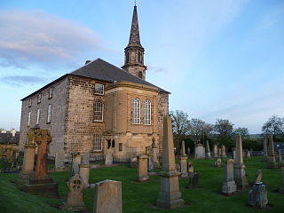
Inveresk Roman Fort is an archaeological site within the grounds of St Michael's Church, Inveresk, a village in East Lothian, Scotland.

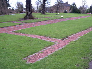
Trawscoed fort is a Roman auxiliary fort in Ceredigion, Wales, located near the modern settlement of Trawsgoed and is cut through by the modern B4340 road. It was first built in the 70s AD. and was occupied until around 130 AD, housing up to 800 infantry in rows of barracks within the 2.1 hectares banked enclosure. At its height it could have had a total population of around 2,000 people living at the fort and its extramural vicus. It overlooks the Roman bridge over the River Ystwyth, which is where the road from Pen-Ilwyn to Llanio crosses. In 1959, this site was initially identified via aerial photography revealing a series of parchmarks covering an area of around 20,000 square metres (2 ha). Later explorations increased the knowledge of this site.

Derventio was a Roman settlement at Papcastle on the river Derwent near Cockermouth, Cumbria, England. It was the site of a Roman fort, which was originally built in timber and rebuilt in stone. There was also a civilian settlement (vicus). It is sometimes called Derventio Carvetiorum by modern writers to distinguish it from other places named Derventio, but there is no evidence of that extended name being used in the Roman period.

<span class="mw-page-title-main">Navio Roman Fort</span> Roman fort near Hope in Derbyshire, England

Navio Roman fort overlooks a tight bend of the River Noe at Brough-on-Noe near Hope, Derbyshire, in England. Navio fort and vicus is a Scheduled Monument.

References

  1. The Ravenna Cosmography is a 7th century list of place names from the Roman World. In 1949 Richmond and Crawford published an article [4] showing how British entries were ordered so as to follow routes along Roman roads, thus enabling a match with known places, in this case Roman forts along the road from Caerleon to west Wales.
  1. 1 2 DAT PRN: 5998 Dyfed Archaeological Trust. Accessed 11 March 2014.
  2. 1 2 3 4 5 6 coflein NPRN: 303530 accessed 15 October 2013
  3. Cadw SAM No: CD129, Llanio Roman Fort and Bathhouse
  4. 1 2 Richmond, I.A.; Crawford, O.G.S. (1949). "I.—The British Section of the Ravenna Cosmography". Archaeologia: Or Miscellaneous Tracts Relating to Antiquity. 93: 1–50.
  5. 1 2 roman-britain.co.uk bremia.
  6. Richmond, I.A.; Crawford, O.G.S. (1949). "I.—The British Section of the Ravenna Cosmography". Archaeologia: Or, Miscellaneous Tracts Relating to Antiquity. 93: 1–50.
  7. Llanio Trawscoed geophys survey report, David Hopewell, 2006 Accessed 16 October 2013.