There are many Roman sites in Great Britain that are open to the public. There are also many sites that do not require special access, including Roman roads, and sites that have not been uncovered.

The Demetae were a Celtic people of Iron Age and Roman period, who inhabited modern Pembrokeshire and Carmarthenshire in south-west Wales. The tribe also gave their name to the medieval Kingdom of Dyfed, the modern area and county of Dyfed and the distinct dialect of Welsh spoken in modern south-west Wales, Dyfedeg.

Llandeilo is a town and community in Carmarthenshire, Wales, situated at the crossing of the River Towy by the A483 on a 19th-century stone bridge. Its population was 1,795 at the 2011 Census. It is adjacent to the westernmost point of the Brecon Beacons National Park. The town is served by Llandeilo railway station on the Heart of Wales Line.

Llandovery is a market town and community in Carmarthenshire, Wales. It lies on the River Tywi and at the junction of the A40 and A483 roads, about 25 miles (40 km) north-east of Carmarthen, 27 miles (43 km) north of Swansea and 21 miles (34 km) west of Brecon.

Llanddewi Brefi is a village, parish and community of approximately 500 people in Ceredigion, Wales. The village is notable for the famous Synod of Brefi held here in the sixth century. A number of miraculous events are said to have occurred during the synod, most notably by Saint David Welsh: Dewi Sant, patron saint of Wales. Today, it is one of the largest parishes in Wales and lies 7 miles (11 km) north-east of Lampeter between Tregaron and Llanfair Clydogau. It is in the electoral ward of Llangeitho.
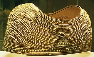
Welsh gold is gold found in natural geological deposits in two distinct areas of Wales and highly prized because of its origin and scarcity.
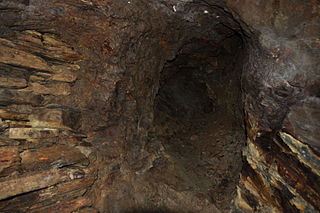
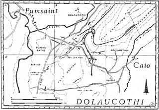
The Dolaucothi Gold Mines, also known as the Ogofau Gold Mine, are ancient Roman surface and underground mines located in the valley of the River Cothi, near Pumsaint, Carmarthenshire, Wales. The gold mines are located within the Dolaucothi Estate, which is owned by the National Trust.

Pumsaint is a village in Carmarthenshire, Wales, halfway between Llanwrda and Lampeter on the A482 in the valley of the Afon Cothi. It forms part of the extensive estate of Dolaucothi, which is owned by the National Trust.

Llanwrda ( ) is a village and community in Carmarthenshire, Wales, 4 miles (6.4 km) southwest of Llandovery. It lies on the River Towy. The population in 2011 was 514.

Sarn Helen refers to several stretches of Roman road in Wales. The 160-mile (260 km) route, which follows a meandering course through central Wales, connects Aberconwy in the north with Carmarthen in the west. Despite its length, academic debate continues as to the precise course of the Roman road. Many sections are now used by the modern road network while other parts are still traceable. However, there are sizeable stretches that have been lost and are unidentifiable.
Geraint Dyfed Barri Jones was a classical scholar and archaeologist.

Caio is a village in the county of Carmarthenshire, south-west Wales, sited near to the Dolaucothi Gold Mines.
The rectangular enclosure that defined this Roman fort was built in the 70s AD as part of the campaign to integrate southern Wales into the Roman province of Britannia Superior. It lay on a key road, now known as the Sarn Helen (RR69), from the legionary fortress of Isca Augusta (Caerleon) that ran north west across Wales to Bremia and on to North Wales. It also sat on a road running from Moridunum (Carmarthen) across to eastern Wales at Castell Collen. It thus held an important crossroads along with a bridging point over the River Towy, and the town that grew up near the fort retained its significance and became Llandovery.

Llansadwrn is a small village and community in Carmarthenshire, Wales.

Cynwyl Gaeo is a parish and community located in rural Carmarthenshire, Wales, near the boundary with Ceredigion, in the upper Cothi valley about halfway between Lampeter and Llandovery. The population of the village at the United Kingdom Census 2011 was 940. It includes the villages of Caio (Caeo), Crug-y-bar, Cwrtycadno, Ffarmers and Pumsaint.

Crugybar is a village in Carmarthenshire, Wales, located between Talley and Pumsaint. It is roughly of equal distance from Lampeter, Llandovery and Llandeilo. It is within the parish of Llanwrda.

Bremia is the name of the Roman fort in the small dispersed settlement of Llanio, West Wales. It is in Llanddewi Brefi community area, south-west of Tregaron, in Ceredigion. The fort was built by the Romans around AD 75 and was in use to AD 120 in Roman Wales. The fort was situated on Sarn Helen, a Roman road leading north from the fort at Dolaucothi. Five inscribed stones have been found within the fort and surrounding military settlement. Two of these have inscriptions which show the garrison to include to a cohort from the Asturias, northern Spain. Amongst the excavations on the site, is the bathhouse. The bathhouse and fort are scheduled monuments, giving them statutory protection from disturbance.

Afon Annell is a small river in Carmarthenshire, Wales.

The Afon Twrch is a short river in Carmarthenshire, West Wales. It joins the River Cothi at the village of Pumsaint, near to which are the Roman gold mines of Dolaucothi.
Trawscoed fort is a Roman auxiliary fort in Ceredigion, Wales, located near the modern settlement of Trawsgoed and is cut through by the modern B4340 road. It was first built in the 70s AD. and was occupied until around 130 AD, housing up to 800 infantry in rows of barracks within the 2.1 hectares banked enclosure. At its height it could have had a total population of around 2,000 people living at the fort and its extramural vicus. It overlooks the Roman bridge over the River Ystwyth, which is where the road from Pen-Ilwyn to Llanio crosses. In 1959, this site was initially identified via aerial photography revealing a series of parchmarks covering an area of around 20,000 square metres (2 ha). Later explorations increased the knowledge of this site.