Flintshire (historic)

Last updated
Flintshire
Sir y Fflint (Welsh)
Flag of Flintshire.svg
Flag adopted in 2015
Wales Historic Counties map Flintshire.svg
Flintshire Brit Isles Sect 5.svg
Flintshire - British Isles.svg

Area
  1831184,905 acres (748.28 km2)
Population
  183160,012 [1]
Density
  18310.32
History
  Created1284
Status Ceremonial county (until 1974)
Administrative county (1889–1974)
Chapman code FLN
GovernmentFlintshire County Council (1889–1974)
   HQ County Hall, Mold, Flintshire

Until 1974, Flintshire (Welsh : Sir y Fflint), also known as the County of Flint, was an administrative county in the north-east of Wales, later classed as one of the thirteen historic counties of Wales.

Contents

Most of what was Flintshire was along the north-east coast of Wales, however the county was notable for having one of the few large county exclaves, the English Maelor (Maelor Saesneg), to survive the Counties (Detached Parts) Act 1844.

The administrative county of Flint was abolished under the Local Government Act 1972 on 1 April 1974, and became part of the new administrative area of Clwyd. The exclaves became part of Wrexham Maelor district – other parts formed the districts of Alyn and Deeside, Delyn and Rhuddlan. A unitary authority, also named Flintshire, was formed in 1996 under the Local Government (Wales) Act 1994, consisting only of the Alyn and Deeside and Delyn districts – the Wrexham Maelor parts now form part of Wrexham County Borough, with the former Rhuddlan district forming the northernmost part of the current Denbighshire unitary authority.

Geography

The former county did not have the same boundaries as the current administrative county of Flintshire; in particular the former county included a large exclave called the English Maelor (Maelor Saesneg); it also included Prestatyn, Rhyl and St Asaph which are now administered as part of modern-day Denbighshire, as well as Bangor-on-Dee and Overton-on-Dee, which are administered as part of Wrexham County Borough. Other exclaves of the historic Flintshire included the manors of Marford and Hoseley, Abenbury Fechan and Bryn Estyn, all on the outskirts of Wrexham, and also a small part of the parish of Erbistock around the Boat Inn. These were all completely surrounded by the historic county of Denbighshire. Additionally, a small part of Flintshire, including the village of Sealand, was isolated across the River Dee when its course was changed to improve navigation.

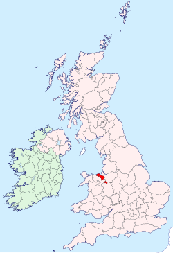
Flintshire was a maritime county bounded to the north by the Irish Sea, to the north-east by the Dee estuary, to the east by Cheshire and to the south and southwest by Denbighshire. The Maelor Saesneg was bounded on the north-west by Denbighshire, on the north-east by Cheshire, and on the south by Shropshire. A medium height range of hills, the Clwydian Range (part of the Clwydian Range and Dee Valley Area of Outstanding Natural Beauty) ran in southeast-northwest direction along the border between the main part of Flintshire and Denbighshire, almost reaching the sea near Prestatyn. The Offa's Dyke Path ran along the crest of these hills.

The highest point in the historic county (county top) was found within these hills at Moel Famau, height 554.8 metres (1,820 ft), a notable viewpoint topped by the ruined remains of the Jubilee Tower, built in 1810 to commemorate the golden jubilee of King George III.

Flintshire was the smallest of what are now known as the historic counties in Wales. The coast along the Dee estuary was heavily developed by industry and the north coast much developed for tourism. The Clwydian Mountains occupied much of the west of the county. The highest point was Moel Famau (1,820 feet / 554 metres). The chief towns were Buckley, Connah's Quay, Flint, Hawarden, Holywell, Mold, Queensferry, and Shotton. The main rivers were the Dee (the estuary of which forms much of the coast) and the Clwyd. The main industries were manufacturing of aircraft components (Airbus), engines (Toyota), paper (Shotton Paper), steel processing (Corus), agriculture and tourism.

Places of special interest included castles in Flint, Hawarden, Rhuddlan and Ewloe, Greenfield Valley, St. Winefride's Well in Holywell and Wepre Country Park, in Connah's Quay.

Formation

The county was formed in 1284 under the terms of the Statute of Rhuddlan, following the defeat of the Principality of Wales. However, the region had been English since the 8th century, and formed part of Cheshire until it was captured by the Welsh in the late 12th century. In the 13th century, prior to its re-capture by the Normans, the region comprised:

Yr Hob and Ystrad Alyn, which been part of Gwynedd earlier in the century, had become sufficiently Welsh that they were regarded as another part of Welsh Maelor, rather than distinguished from it like English Maelor (Maelor Saesneg). They were not initially included in Flintshire, but instead became Marcher Lordships. Yr Hob became the Lordship of Hope, while Ystrad Alyn was split in two - the Lordships of Mold and Hawarden. Following the Laws in Wales Act (1536), these three Lordships were merged into Flintshire.

County offices

County Hall, Mold Flintshire Shire Hall, Mold.jpg
County Hall, Mold

Flintshire County Council established its base at the old County Hall in Chester Street in Mold. [2] Additional facilities acquired included a local militia barracks (originally designed by Thomas Mainwaring Penson) which was converted for use as council offices in the late 1880s. [3] After finding, in the 1930s, that the Chester Street facilities were too cramped, county leaders decided to procure modern facilities: [4] the site they selected formed part of the Llwynegrin Hall estate which was acquired for the purpose. [5] The new building, known as County Hall, Mold, was completed in October 1967. [4]

See also

Related Research Articles

<span class="mw-page-title-main">Denbighshire</span> County in Wales

Denbighshire is a county in the north-east of Wales. It borders the Irish Sea to the north, Flintshire to the east, Wrexham to the southeast, Powys to the south, and Gwynedd and Conwy to the west. Rhyl is the largest town, and Ruthin is the administrative centre. Its borders differ from the historic county of the same name.

<span class="mw-page-title-main">Flintshire</span> County in Wales

Flintshire is a county in the north-east of Wales. It has a maritime border with Merseyside along the Dee Estuary to the north, and land borders with Cheshire to the east, Wrexham County Borough to the south, and Denbighshire to the west. Connah's Quay is the largest town, while Flintshire County Council is based in Mold.

<span class="mw-page-title-main">Denbighshire (historic)</span> Historic county in Wales

Until 1974, Denbighshire, or the County of Denbigh, was an administrative county in the north of Wales, later classed as one of the thirteen historic counties of Wales. It was a maritime county, that was bounded to the north by the Irish Sea, to the east by Flintshire, Cheshire and Shropshire, to the south by Montgomeryshire and Merionethshire, and to the west by Caernarfonshire.

<span class="mw-page-title-main">Clwyd</span> Preserved county of Wales

Clwyd is a preserved county of Wales, situated in the north-east corner of the country; it is named after the River Clwyd, which runs through the area. To the north lies the Irish Sea, with the English ceremonial counties of Cheshire to the east and Shropshire to the south-east. Powys and Gwynedd lie to the south and west respectively. Clwyd also shares a maritime boundary with Merseyside along the River Dee. Between 1974 and 1996, a slightly different area had a county council, with local government functions shared with six district councils. In 1996, Clwyd was abolished, and the new principal areas of Conwy County Borough, Denbighshire, Flintshire and Wrexham County Borough were created; under this reorganisation, "Clwyd" became a preserved county, with the name being retained for certain ceremonial functions.

<span class="mw-page-title-main">River Dee, Wales</span> River in Wales and England

The River Dee is a river flowing through North Wales, and through Cheshire, England, in Great Britain. The length of the main section from Bala to Chester is 113 km and it is largely located in Wales. The stretch between Aldford and Chester is within England, and two other sections form the border between the two countries.

<span class="mw-page-title-main">Maelor</span> Area of Wales

The Maelor is an area of north-east Wales along the border with England. It is now entirely part of Wrexham County Borough. The name Maelor is an old Welsh word: it can be translated as "land of the prince", from mael ("prince") and llawr.

<span class="mw-page-title-main">English Maelor</span> Area of Wrexham County Borough, east of the River Dee

English Maelor, also known by its Welsh name Maelor Saesneg, comprises one half of the Maelor region on the Welsh side of the Wales-England border, being the area of the Maelor east of the River Dee. The region has changed counties several times, previously being part of Cheshire and later a detached portion of Flintshire. The area is currently in Wales, despite its name, and administered as part of Wrexham County Borough.

<span class="mw-page-title-main">Wrexham County Borough</span> County borough in Wales

Wrexham County Borough is a county borough, with city status, in the north-east of Wales. It borders the English ceremonial counties of Cheshire and Shropshire to the east and south-east respectively, Powys to the south-west, Denbighshire to the west and Flintshire to the north-west. The city of Wrexham is the administrative centre. The county borough is part of the preserved county of Clwyd.

<span class="mw-page-title-main">District of Alyn and Deeside</span> Former district of Clwyd, Wales

Alyn and Deeside was one of six local government districts in the county of Clwyd, north-east Wales from 1974 to 1996. There is still a parliamentary constituency of the same name.

<span class="mw-page-title-main">Wrexham Maelor</span> Former district of Clwyd, Wales

Wrexham Maelor was a local government district with borough status, being one of six districts in the county of Clwyd, north-east Wales, from 1974 to 1996.

<span class="mw-page-title-main">Overton-on-Dee</span> Village in Wales

Overton or Overton-on-Dee is a village and community in Wrexham County Borough, Wales. It is situated close to the Welsh-English border on the edge of an escarpment that winds its way around the course of the River Dee, from which Overton-on-Dee derives its name.

<span class="mw-page-title-main">Alyn and Deeside (UK Parliament constituency)</span>

Alyn and Deeside is a parliamentary constituency represented in the House of Commons of the Parliament of the United Kingdom. The constituency was created in 1983, and it elects one Member of Parliament (MP) by the first-past-the-post method of election.

<span class="mw-page-title-main">Flintshire County Council</span> Local government of Flintshire, Wales

Flintshire County Council is the unitary local authority for the county of Flintshire, one of the principal areas of Wales. It is based at County Hall in Mold.

<span class="mw-page-title-main">Clwydian Range</span> Hill range in Wales

The Clwydian Range is a series of hills in the north-east of Wales that runs from Llandegla in the south to Prestatyn in the north; the highest point is 554 m (1,818 ft) Moel Famau. The range forms the north-western part of the Clwydian Range and Dee Valley Area of Outstanding Natural Beauty.

<span class="mw-page-title-main">Powys Fadog</span> Northern realm of Powys

Powys Fadog was the northern portion of the former princely realm of Powys. The princes of Powys Fadog would build their royal seat at Castell Dinas Brân, and their religious center at Valle Crucis Abbey. Some of its lordships included those of Maelor, Mochnant, Glyndyfrdwy, Yale, and Bromfield and Yale. Following the division of Powys, their cousin branch, the princes of Powys Wenwynwyn, would build Powis Castle.

Maelor was a rural district in the administrative county of Flintshire, Wales, from 1894 to 1974. The area approximated to the hundred of Maelor or English Maelor, and was notable for forming a detached part of the county, surrounded by Cheshire, Denbighshire and Shropshire. The administrative centre was located at Overton.

<span class="mw-page-title-main">Penley</span> Village in Wales

Penley is a village in the County Borough of Wrexham, in Wales close to the border with Shropshire, England, and had a population of 606 as of the 2011 census.

<span class="mw-page-title-main">Wych Brook</span> River in Wales and England

The Wych Brook, Worthenbury Brook and Red Brook, formerly known as the River Elfe, is a tributary of the River Dee in England and Wales, forming part of both the historic and present-day border between the two countries. The stream forms part of the border between Cheshire and Shropshire in England to the east, and Wales, particularly the Maelor Saesneg, to the west.

<span class="mw-page-title-main">Whitewell, Wrexham</span> Rural settlement in Wales

Whitewell is a dispersed rural settlement, and surrounding ecclesiastical parish, in the community of Bronington, in the east of Wrexham County Borough, Wales.

<span class="mw-page-title-main">Clwydian Range and Dee Valley</span> Area of Outstanding Natural Beauty in Wales

The Clwydian Range and Dee Valley is a designated Area of Outstanding Natural Beauty (AONB) located in north-east Wales, covering the Clwydian Range, and the valley of the River Dee.

References

  1. Vision of Britain – 1831 Census
  2. Cadw. "Old County Hall (360)". National Historic Assets of Wales . Retrieved 15 April 2020.
  3. Hubbard, Edward (1986), Clwyd, The Buildings of Wales, London: Penguin, pp. 393–395, ISBN   0-14-071052-3
  4. 1 2 "Mold's modernist masterpiece Shire Hall marks 50 years of civic service". Leader Live. 30 May 2018. Retrieved 18 October 2019.
  5. "Ordnance Survey Ma". 1914. Retrieved 1 November 2020.

53°15′N3°10′W / 53.250°N 3.167°W / 53.250; -3.167