
A chambered cairn is a burial monument, usually constructed during the Neolithic, consisting of a sizeable chamber around and over which a cairn of stones was constructed. Some chambered cairns are also passage-graves. They are found throughout Britain and Ireland, with the largest number in Scotland.

Gower or the Gower Peninsula is in South West Wales and is the most westerly part of the historic county of Glamorgan, Wales. It projects towards the Bristol Channel. In 1956, the majority of Gower became the first area in the United Kingdom to be designated an Area of Outstanding Natural Beauty.
Rathcroghan is a complex of archaeological sites near Tulsk in County Roscommon, Ireland. It is identified as the site of Cruachan, the traditional capital of the Connachta, the prehistoric and early historic rulers of the western territory. The Rathcroghan Complex is a unique archaeological landscape with many references found in early Irish medieval manuscripts.

Knowth is a prehistoric monument overlooking the River Boyne in County Meath, Ireland. It comprises a large passage tomb surrounded by 17 smaller tombs, built during the Neolithic era around 3200 BC. It contains the largest assemblage of megalithic art in Europe. Knowth is part of the Brú na Bóinne complex, a World Heritage Site that also includes the similar passage tombs of Newgrange and Dowth.

Bodowyr Burial Chamber is a Neolithic burial chamber made of a few large stacked stones in a farmer's field on the north Wales island of Anglesey. It is located at Bodowyr Farm, 1.25 mi (2.0 km) east of Llangaffo, off the B4419 road.

Tievebulliagh is a 402-metre-high (1,319 ft) mountain in the Glens of Antrim, Northern Ireland. It forms part of the watershed between Glenaan to the north and Glenballyemon to the south. It is situated about 4.4 km from Cushendall.

Tinkinswood or its full name Tinkinswood Burial Chamber, also known as Castell Carreg, Llech-y-Filiast and Maes-y-Filiast, is a megalithic burial chamber, built around 6,000 years ago, during the Neolithic period, in the Vale of Glamorgan, near Cardiff, Wales.

Lligwy Burial Chamber is a Neolithic burial chamber in Lligwy, near the east coast of Anglesey, Wales, United Kingdom. It consists of a circle of upright stones, made into a low chamber by a very large roof slab estimated at 25 tonnes. Excavation in 1909 found the remains of some 15 to 30 people, and pottery suggesting a late Neolithic date. Close to the village of Moelfre, the site is within a few metres of the road, where there is room to leave a single car for short periods.

The St Lythans burial chamber is a single stone megalithic dolmen, built around 4,000 BC as part of a chambered long barrow, during the mid Neolithic period, in what is now known as the Vale of Glamorgan, Wales.

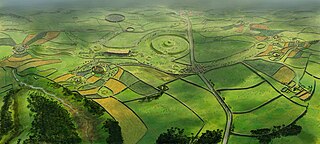
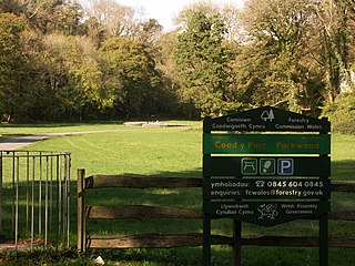
Parc Cwm long cairn, also known as Parc le Breos burial chamber, is a partly restored Neolithic chambered tomb, identified in 1937 as a Severn-Cotswold type of chambered long barrow. The cromlech, a megalithic burial chamber, was built around 5,850 years before present (BP), during the early Neolithic. It is about seven 1⁄2 miles (12 km) west south–west of Swansea, Wales, in what is now known as Coed y Parc Cwm at Parc le Breos, on the Gower Peninsula.
Parc le Breos was a great medieval deer park in the south of the Gower Peninsula, about eight miles (13 km) west of Swansea, Wales, and about 1+1⁄4 miles (2.0 km) north of the Bristol Channel. The park was an enclosed, oval area of 6.7 miles (10.8 km) in circumference, covering about 2,000 acres (810 ha) and measuring 2+1⁄2 miles (east–west) by just over 1+3⁄4 miles. Parc le Breos was established in the 1220s CE by John de Braose, Marcher Lord of Gower and husband to Margaret Ferch Llywelyn, Llywelyn Fawr's daughter. Other than for deer husbandry, the park received an income from agistment, pannage, and from sales of wild honey, ferns and dead wood. There is evidence of rabbit warrens in the park. Whether the warrens were free or domestic is unknown.

Mynydd Llangatwg or Llangattock Mountain is a hill in the Brecon Beacons National Park in the county of Powys, south Wales. It is named from the village of Llangatwg which sits in the valley of the River Usk to the north of it. It is essentially an undulating plateau rising in the west to a height of 530 metres (1,740 ft) at grid reference SO171157 and in the east to a height of 529 metres (1,736 ft) at Hen Dy-aderyn / Twr Pen-cyrn. This spot is marked by a trig point. The shallow pool of Pwll Gwy-rhoc sits in a broad depression towards the northern edge of the plateau whilst a smaller pool frequently occupies a large shakehole a few hundred metres to its west. The hill forms an impressive northern scarp overlooking the Usk valley and commonly referred to as the Llangattock Escarpment. Its southern margins are more subdued. Its eastern end is defined by the drops into the Clydach Gorge. Beyond the B4560 to the west the hill merges with Mynydd Llangynidr which has a similar character.

Trelawnyd is a village in Flintshire, Wales. The village had a population taken at the 2011 census of 584. It is part of the community of Trelawnyd and Gwaenysgor.

Cathole Cave, Cat Hole Cave or Cathole Rock Cave, is a cave near Parc Cwm long cairn at Parc le Breos, on the Gower Peninsula, Wales. It is a steep limestone outcrop, about 200 yards (180 m) north of the cromlech along the Parc le Breos Cwm valley and near the top of the gorge, about 50 feet (15 m) from the valley floor. The cave is a deep triangular fissure penetrating the hillside and narrowing towards the top. It has two entrances, with a natural platform outside the larger of the two. It is about seven 1⁄2 miles (12 km) west south–west of Swansea, Wales, in what is now known as Coed y Parc Cwm at Parc le Breos, on the Gower Peninsula.

Tref Alaw is a community in Anglesey, north Wales. The community takes in the area west and south west of the Llyn Alaw, a man made reservoir which is also the largest body of water on the island. The community consists of a wide network of dispersed farms, and five settlements. Two small villages, close to each other in the centre of the community area are Llanddeusant and Elim. Llantrisant is a hamlet a mile or so to the south-west of Elim. In the north west is the small village of Llanbabo, and in the far south is the tiny hamlet of Llechgynfarwy, of which the principal building is St Cynfarwy's Church. At the 2001 census the community had a population of 606 inhabitants, reducing to 581 at the 2011 census.

Din Dryfol is a Neolithic burial chamber on Anglesey, in Wales. It is a scheduled monument and is maintained by Cadw. The monument is near Bethel. Three phases of use have been identified, all dating from the Neolithic period.

Trefignath is a Neolithic burial chamber near Trearddur, south of Holyhead on Holy Island, off Anglesey in Wales. In its most complete form it included a large cairn covering three stone tombs, set on a small knoll. It was excavated between 1977 and 1979, revealing several phases of occupation with three separate burial chambers built in succession. It is a scheduled ancient monument, maintained by Cadw.

Pant-y-Saer is a Neolithic dolmen near the small town of Benllech in Anglesey, Wales. This burial chamber is partially collapsed with the massive capstone resting on the ground at one end. The remains of fifty-six people who were buried here have been found during excavations.

Knowe of Yarso chambered cairn is a Neolithic burial monument located on the island of Rousay in Orkney, Scotland. The site was excavated in the 1930s, and uncovered human and animal bones as well as pottery sherds, flint and bone tools, and arrowheads. The tomb, dating to the period between 3500 and 2500 BC, is a stalled chambered cairn, similar to Midhowe and Blackhammer. Historic Environment Scotland established the site as a scheduled monument in 1994.

