Cilcain

Last updated

Cilcain
Village and community
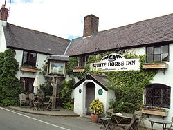
White Horse Inn, Cilcain - DSC06082.JPG
The White Horse Inn, in the Village Centre
Flintshire UK location map.svg
Red pog.svg
Cilcain
Location within Flintshire
Population1,340 (2021) [1] [2]
OS grid reference SJ1765
Community
  • Cilcain
Principal area
Preserved county
Country Wales
Sovereign state United Kingdom
Settlements [1] Cilcain, Rhydymwyn
Post town MOLD
Postcode district CH7
Dialling code 01352
Police North Wales
Fire North Wales
Ambulance Welsh
UK Parliament
Senedd Cymru – Welsh Parliament
Website Council website
List of places
UK
Wales
Flintshire

53°10′00″N3°14′00″W / 53.1667°N 3.2333°W / 53.1667; -3.2333

Contents

2024 Wales Flintshire Community Cilcain map.svg
Map of the community

Cilcain is a village and community, near Mold, in Flintshire, north-east Wales. The village has an industrial history and includes the Millennium Woods, a post office, a public house, a parish church, a primary school (Ysgol y Foel) and a village hall.

Cilcain borders the parishes of Rhosesmor, Rhes-y-cae and Rhydymwyn. The community includes the village of Rhydymwyn.

Cilcain every year has a Cilcain show. The Cilcain show happens at the village hall. There are usually fairs and a dog show. Also a junior and adults race either up Moel Famau or just up a little bit up the mountain.

Name

The Welsh placename Cilcain, which has also in the past been spelled as Kilken and Cilcen, has been suggested[ by whom? ] to derive from cil meaning 'retreat' [3] and cain meaning 'fair' or 'pleasant' [4] in the Welsh language.

Early Cilcain

In the early years of Cilcain's existence it was noted as a place of retreat and was also locally famous for its regular village fairs, where a notable amount of alcohol was often consumed. Cilcain was also known for cockfighting, which took place on Sundays after the local church service.

Church

The first recorded mention of the church at Cilcain dates from 1291. Cilcain is one of the "ancient parishes" of Flintshire. It originally comprised the seven townships of Cefn, Llan (or Tre'r Llan), Llystynhunydd (or Glust), Llys y Coed, Maes y Groes, Mechlas (or Dolfechlas), and Trellyniau. On 27 June 1848, the township of Trellyniau and part of the township of Llystynhunydd went to the new parish of Rhes-y-Cae. On 31 March 1865, the remainder of Llystynhunydd, and parts of the townships of Cefn and Mechlas, went to the new parish of Rhydymwyn.

Governance

Cilcain Community Council is divided into two wards, Cilcain and Rhydymwyn, each of which elects six councillors. [5] The Cilcain and Nannerch communities make up the Cilcain electoral ward on Flintshire County Council, which elects one councillor. [6] It had a population of 1,790 at the 2021 census. [7] Caerwys is part of the Delyn constituency and North Wales region for the Senedd, and of the Delyn constituency for parliament.

Millennium Woods

The Millennium Woods were planted in 2000 through the 'Woods on your doorstep' scheme of the Woodland Trust. Many of the trees were planted by some of the students attending the local school, Ysgol y Foel, in that year. The official name is Coed y Felin ('Mill Woods'), named after the disused mill that now lies in ruins by the stream below.

See also

Related Research Articles

<span class="mw-page-title-main">Llangynwyd</span> Village in Wales

Llangynwyd is a village 2 miles to the south of Maesteg, in the county borough of Bridgend, Wales. It was part of the medieval commote of Tir Iarll.

<span class="mw-page-title-main">Caerwys</span> Town and community in Flintshire, Wales

Caerwys is a town and community in Flintshire, Wales. It is just under two miles from the A55 North Wales Expressway and one mile from the A541 Mold-Denbigh road. At the 2001 Census, the population of Caerwys community was 1,315, with a total ward population of 2,496. Following reorganisation the community population fell at the 2011 Census to 1,283 with the ward raising to 2,569. The community includes Afonwen.

<span class="mw-page-title-main">Bagillt</span> Village and community in Wales

Bagillt is a village and community in Flintshire, Wales. The village overlooks the Dee Estuary and is between the towns of Holywell and Flint. At the 2001 Census the population was recorded as 3,918, increasing to 4,165 at the 2011 census. The community also includes the settlements of Coleshill, Walwen and Whelston.

<span class="mw-page-title-main">Llansantffraid-ym-Mechain</span> Human settlement in Wales

Llansantffraid-ym-Mechain is a large village in Powys, Mid Wales, close to the border with Shropshire in England, about 7 miles (11 km) south-west of Oswestry and 8 miles (13 km) north of Welshpool. It is on the A495 road and is at the confluence of the River Vyrnwy and the River Cain. The population as of the 2011 UK census was 1,415. The community includes the village of Deuddwr and several hamlets.

<span class="mw-page-title-main">Treuddyn</span> Village and community in Flintshire, Wales

Treuddyn is a village, community and electoral ward in Flintshire, Wales, located just off the A5104 road, around 4 miles south-east of Mold and 3 miles north-west of Caergwrle. The community includes the nearby village of Coed Talon, to the east, and Rhydtalog, to the south-west on the Denbighshire border.

<span class="mw-page-title-main">Nannerch</span> Village and community in Flintshire, Wales

Nannerch is a village and community in Flintshire, Wales, located within the Clwydian Range and Dee Valley Area of Outstanding Natural Beauty. At the 2001 Census the population of Nannerch was 531, reducing to 496 in 2011.

<span class="mw-page-title-main">Rhosesmor</span> Village in Flintshire, Wales

Rhosesmor is a small village near Mold, Flintshire, in north-east Wales. The village lies near the parishes of Halkyn and Rhes-y-cae. The hamlet of Wern-y-Gaer is encompassed by the boundaries of the village.

<span class="mw-page-title-main">Halkyn</span> Village and community in Flintshire, Wales

Halkyn is a village and community in Flintshire, north-east Wales and situated between Pentre Halkyn, Northop and Rhosesmor. At the 2001 Census the population of the community was 2,876, increasing slightly to 2,879 at the 2011 Census. Pentre Halkyn is in the community.

<span class="mw-page-title-main">Gwersyllt</span> Village in Wales

Gwersyllt is an urban village and community in Wrexham County Borough, Wales.

<span class="mw-page-title-main">Ysceifiog</span> Village and community in Flintshire, Wales

Ysceifiog, also spelled as Ysgeifiog, is a village and community in Flintshire, Wales. It lies on a back road just north of the A541 highway between Nannerch and Caerwys. The name translates roughly as "a place where elder trees grow".

<span class="mw-page-title-main">Rhydymwyn</span> Village in Flintshire, Wales

Rhydymwyn is a village in Flintshire, Wales, located in the upper Alyn valley. Once a district of Mold, it was recognised as a separate parish from 1865. It is now part of the community of Cilcain.

<span class="mw-page-title-main">Rhes-y-cae</span> Human settlement in Wales

Rhes-y-cae is a small parish and village in Flintshire, Wales. Literally translated from Welsh, Rhes-y-cae is 'Row of fields'. It is situated between Pentre Halkyn and Rhosesmor and is part of the local government community of Halkyn. Local facilities include a chapel, a church and a park, which is situated next to Ysgol Rhes-y-cae. The school closed in 2013, due to there being too few students to warrant its continued operation.

<span class="mw-page-title-main">Llanfynydd, Flintshire</span> Village and community in Flintshire, Wales

Llanfynydd is a village, local government community and electoral ward in Flintshire, Wales. Its name is derived from the Welsh words llan, and mynydd ("mountain").

<span class="mw-page-title-main">Llandyssil</span> Village in Powys, Wales

Llandyssil is a village in the community of Abermule with Llandyssil, in Powys, Wales, in the traditional county of Montgomeryshire. It is about two miles from the town of Montgomery.

<span class="mw-page-title-main">Townships in Montgomeryshire</span>

Townships in Montgomeryshire are divisions of the ancient parishes of the county of Montgomery. In 1539 townships were grouped together in Hundreds. The Townships which were recognised were based on the older Welsh divisions of Tref, or plural Trefi, which had formed the Welsh administrative districts of the Commote. Not all of the former Tref were recognised and some smaller trefi were amalgamated into larger townships. A township was allocated to a particular parish—that is, one of the [civil] parishes of Wales, the predecessors to today's communities of Wales. The townships were recognised as administrative districts, rather than the parishes.

References

  1. 1 2 in the Cilcain community
  2. "Cilcain". UK Census Data 2021. Retrieved 9 May 2023.
  3. "cil". Welsh-English / English-Welsh On-Line Dictionary. University of Wales Trinity Saint David. Retrieved 18 July 2024.
  4. "cain". Welsh-English / English-Welsh On-Line Dictionary. University of Wales Trinity Saint David. Retrieved 18 July 2024.
  5. "Your Councillors and Clerk". Cilcain Council. Retrieved 10 May 2023.
  6. "Electoral Arrangements for Flintshire". Flintshire County Council. Retrieved 7 May 2023.
  7. "Cilcain". UK Census Data 2021. Retrieved 9 May 2023.