Related Research Articles
Shire is a traditional term for an administrative division of land in Great Britain and some other English-speaking countries. It is generally synonymous with county. British counties are among the oldest extant national divisions in the world.

The historic counties of England are areas that were established for administration by the Normans, in many cases based on earlier kingdoms and shires created by the Angles, Saxons, Jutes, Celts and others. They are alternatively known as ancient counties, traditional counties, former counties or simply as counties. In the centuries that followed their establishment, as well as their administrative function, the counties also helped define local culture and identity. This role continued even after the counties ceased to be used for administration after the creation of administrative counties in 1889, which were themselves amended by further local government reforms in the years following.

The counties of England are a type of subdivision of England. Counties have been used as administrative areas in England since Anglo-Saxon times. There are three definitions of county in England: the 48 ceremonial counties used for the purposes of lieutenancy; the 84 metropolitan and non-metropolitan counties for local government; and the 39 historic counties which were used for administration until 1974.
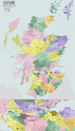
The Shires of Scotland, or Counties of Scotland, were historic subdivisions of Scotland.

Lieutenancy areas, officially counties and areas for the purposes of the lieutenancies, are the separate areas of the United Kingdom appointed to a lord-lieutenant – a representative of the British monarch. In many cases they have similar demarcation and naming to, but are not necessarily coterminate with, the counties of the United Kingdom.
A lord-lieutenant is the British monarch's personal representative in each lieutenancy area of the United Kingdom. Historically, each lieutenant was responsible for organising the county's militia. Lord-lieutenant is now an honorary titular position usually awarded to a retired notable person in the county.

The First Protectorate Parliament was summoned by the Lord Protector Oliver Cromwell under the terms of the Instrument of Government. It sat for one term from 3 September 1654 until 22 January 1655 with William Lenthall as the Speaker of the House.

Chain Home Low (CHL) was the name of a British early warning radar system operated by the RAF during World War II. The name refers to CHL's ability to detect aircraft flying at altitudes below the capabilities of the original Chain Home (CH) radars, where most CHL radars were co-located. CHL could reliably detect aircraft flying as low as 500 feet (150 m). The official name was AMES Type 2, referring to the Air Ministry Experimental Station at Bawdsey Manor where it was developed, but this name was almost never used in practice.
New Years' Honours are announced on or around the date of the New Year in Australia, Canada, New Zealand and the United Kingdom. The dates vary, both from year to year and from country to country. All are published in supplements to the London Gazette and many are conferred by the monarch some time after the date of the announcement, particularly for those service people on active duty.

The following outline is provided as an overview of and topical guide to England:

The following is an alphabetical list of articles related to the United Kingdom.

The historic counties of the United Kingdom are ancient geographical divisions of the United Kingdom. Although not defined by any one function, over many centuries, various forms of administrative function have been based on them. These have included the areas of parliamentary constituencies, the court of quarter sessions, the areas in which a lord-lieutenant and sheriff serve, territorial units of the Militia, as well as the basis of the original county councils. Although these areas have subsequently changed, the historic counties on which they were originally based have not. The Office for National Statistics recommended them in the Index of Place Names as a stable, unchanging geography which covers the whole of Great Britain.
References
- The Chapman County Code for British Isles Counties, Lochin Publishing, accessed 13 October 2019