West Riding of Yorkshire

Last updated

County of York, West Riding
Flag of the West Riding of Yorkshire.svg
Flag of West Riding (2013)
West Riding locator in England.svg
1888–1974: County of York in England: West Riding (red), North Riding (light green), and East Riding (very pale green)
Area
  19111,685,409 acres (6,820.61 km2)
  19611,621,068 acres (6,560.23 km2)
Population
  19011,538,572
History
  Created
  • Historic riding: AD 889
  • Administrative county: 1889
  Abolished
  • Historic riding: not abolished
  • Administrative county: 1974
  Succeeded by
Status Ancient riding,
then administrative county
Chapman code WRY
Government
   HQ Wakefield
   Motto Audi consilium (Heed counsel) [1]
Arms of West Riding County Council.svg
Coat of arms of West Riding County Council

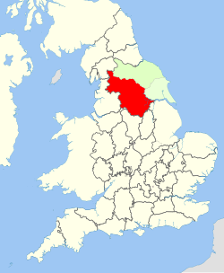
The West Riding of Yorkshire was one of three historic subdivisions of Yorkshire, England. From 1889 to 1974 the riding was an administrative county named County of York, West Riding. The lieutenancy at that time included the city of York and as such was named "West Riding of the County of York and the County of the City of York". [2] The riding ceased to be used for administrative purposes in 1974, when England's local government was reformed.

Contents

Contemporary local government boundaries in Yorkshire largely do not follow those of the riding. All of South Yorkshire and West Yorkshire were historically within its boundaries, as were the south-western areas of North Yorkshire (including Ripon), the Sedbergh area of Cumbria, the Barnoldswick and Slaidburn areas of Lancashire, and the part of the East Riding of Yorkshire around Goole.

Geography

The West Riding encompassed 1,771,562 acres (7,169 km2) from Sheffield in the south to Sedbergh in the north and from Dunsop Bridge in the west to Adlingfleet in the east.

The southern industrial district, considered in the broadest application of the term, extended northward from Sheffield to Skipton and eastward from Sheffield to Doncaster, covering less than one-half of the riding. Within this district were Barnsley, Batley, Bradford, Brighouse, Dewsbury, Doncaster, Halifax, Huddersfield, Keighley, Leeds, Morley, Ossett, Pontefract, Pudsey, Rotherham, Sheffield, Todmorden (partly in Lancashire until 1888, when fully incorporated into Yorkshire) and Wakefield. Major centres elsewhere in the riding included Harrogate and Ripon.

Within the industrial region, other urban districts included Bingley, Bolton on Dearne, Castleford, Cleckheaton, Elland, Featherstone, Handsworth, Hoyland Nether, Liversedge, Mexborough, Mirfield, Normanton, Rawmarsh, Rothwell, Saddleworth, Shipley, Skipton, Sowerby Bridge, Stanley, Swinton, Thornhill, Wath-upon-Dearne, Wombwell and Worsborough. Outside the industrial region were Goole, Ilkley, Knaresborough, Otley and Selby. The West Riding also contained a large rural area to the north including part of the Yorkshire Dales National Park (the remainder of the park being in the North Riding).

History

The subdivision of Yorkshire into three ridings or "thirds" (Old Norse : Þriðungr) is of Scandinavian origin. The West Riding was first recorded (in the form West Treding) in the Domesday Book of 1086. [3]

Unlike most English counties, Yorkshire, being so large, was divided first into the three ridings (East, North and West) and, later, the city of York (which lay within the city walls and was not part of any riding). Each riding was then divided into wapentakes, a division comparable to the hundreds of southern and western England and the wards of England's four northernmost historic counties.

Administrative county

A variation of the West Riding's coat of arms seen in Wetherby, now in West Yorkshire. West Riding of Yorkshire coat of arms, Wetherby (Taken by Flickr user 6th July 2014).jpg
A variation of the West Riding's coat of arms seen in Wetherby, now in West Yorkshire.

The administrative county was formed in 1889 by the Local Government Act 1888, and covered the historic West Riding except for the larger urban areas, which were county boroughs with the powers of both a municipal borough and a county council. Initially there were five in number: Bradford, Leeds, Huddersfield, Halifax, and Sheffield. The City of York (also a county borough) was included in the county for census and lieutenancy purposes. The number of county boroughs increased over the years; Rotherham gained this status in 1902, Barnsley and Dewsbury in 1913, Wakefield in 1915 and Doncaster in 1927. The boundaries of existing county boroughs were also widened.

Beginning in 1898, the West Riding County Council was based at the County Hall in Wakefield, which was inherited by the West Yorkshire Metropolitan County Council in 1974. [4]

The Local Government Act 1888 included the entirety of Todmorden with the West Riding administrative county, and also in its lieutenancy area ("county"), though the postal address for Todmorden was Lancashire. Other boundary changes in the county included the expansion of the county borough of Sheffield southward in areas historically in Derbyshire such as Dore.

Fingerposts erected in the West Riding until the mid-1960s had a distinctive style. At the top of the post was a roundel in the form of a hollow circle with a horizontal line across the middle, displaying "Yorks W.R.", the name of the fingerpost's location, and a grid reference. Other counties, apart from Dorset, [5] did not display a grid reference and did not have a horizontal bar through the roundel. From 1964, many fingerposts were replaced by ones in the modern style, but some of the old style still survive within the West Riding boundaries.

By 1971 1,924,853 people (or 50.85% of the West Riding's population) lived in the administrative county, against 1,860,435 (or 49.15%) in the ten county boroughs.

Divisions

Ancient riding

Earlier

In the Domesday Book of 1086 they were eleven wapentakes, these were as follows: [6]

Domesday nameLater nameAlso known as/ division namesOther status post-Domesday
Agbrigg Agbrigg and Morley (temporarily)
MorleyBlackston Edge, Bradfordale or Sowerbyshire
Ainsty Ainsty of YorkJoined the City of York outside the Riding system in the 15th century
Barkston Barkston Ash Jointly known as Elmet
Skyrack Skyrack Upper Airedale
Skyrack Lower
Burghshire (of Aldborough) Claro Upper Wharfedale, Nidderdale, of Knaresborough, Riponshire or Kirbyshire Liberty and Honour
Claro Lower
Strafforth Strafforth and Tickhill Upperof Mexborough, of Tickhill, Hallam or Hallamshire Liberty or Honour
Strafforth or Tickhill Lower
Craven/ Cravenshire Staincliffe West Ribblesdale or Bowland Temporarily merged into Staincliffe and Ewecross Honour
Staincliffe EastStaincliffe, of Skipton or Craven
Ewecross
Osgoldcross MarshlandLiberty
Staincross

Later

Wapentakes Wapentakes of the West Riding of Yorkshire.png
Wapentakes

In the end of regular use, the wapentakes were:

  1. Ewcross
  2. Staincliffe West
  3. Staincliffe East
  4. Claro Lower
  5. Strafforth and Tickhill Lower
  6. Morley
  7. Skyrack Upper
  8. Claro Upper
  9. Skyrack Lower
  10. Barkston Ash
  11. Agbrigg
  12. Staincross
  13. Osgoldcross
  14. Strafforth and Tickhill Upper

Riding as a county

West Yorkshire County.png
The system of districts and boroughs of the West Riding which formed West Yorkshire
South Yorkshire County.png
The system of districts and boroughs of the West Riding which formed South Yorkshire

During the West Riding's time as a county; rural districts, Urban districts and municipal boroughs were under the administrative county while county boroughs were in the wider geographic county.

Current usage

The West Riding flag registered with the Flag Institute West Riding flag.svg
The West Riding flag registered with the Flag Institute

The term "West Riding" continues to be used by organisations based in the historic area of the riding, such as the West Riding Sailing Club, [7] the Ramblers, [8] the West Riding County Football Association, and the Freemasons. [9] It is also retained in the name of some British Army squadrons, such as the 106 (West Riding) Field Squadron, [10] and some historical re-enactment groups. [11] [12] A flag designed to represent the West Riding was registered with the Flag Institute charity in 2013. [13]

See also

Related Research Articles

<span class="mw-page-title-main">South Yorkshire</span> County of England

South Yorkshire is a ceremonial county in the Yorkshire and the Humber region of England. It borders North Yorkshire and West Yorkshire to the north, the East Riding of Yorkshire to the north-east, Lincolnshire to the east, Nottinghamshire to the south-east, and Derbyshire to the south and west. The largest settlement is the city of Sheffield.

<span class="mw-page-title-main">Doncaster</span> City in South Yorkshire, England

Doncaster is a city in South Yorkshire, England. Named after the River Don, it is the administrative centre of the City of Doncaster metropolitan borough, and is the second largest settlement in South Yorkshire after Sheffield. Noted for its horse racing and railway history, it is situated in the Don Valley on the western edge of the Humberhead Levels and east of the Pennines. The built up area had a population of 87,455 at the 2021 census, whilst the wider metropolitan borough had a population of 308,100.

<span class="mw-page-title-main">North Riding of Yorkshire</span> Third of a historic county in England

The North Riding of Yorkshire was a subdivision of Yorkshire, England, alongside York, the East Riding and West Riding. The riding's highest point was at Mickle Fell at 2,585 ft (788 m).

<span class="mw-page-title-main">Darton</span> Village in South Yorkshire, England

Darton is a large village in the Metropolitan Borough of Barnsley, on the border with West Yorkshire, England. At the time of the 2001 UK census, it had a population of 14,927, increasing to 21,345 for both Darton Wards at the 2011 Census.

<span class="mw-page-title-main">Tickhill</span> Town and civil parish in South Yorkshire, England

Tickhill is a market town and civil parish in the City of Doncaster, South Yorkshire, England, close to the border with Nottinghamshire. At the 2001 census it had a population of 5,301, reducing to 5,228 at the 2011 Census.

<span class="mw-page-title-main">City of Doncaster</span> Metropolitan borough in England

The City of Doncaster is a metropolitan borough with city status in South Yorkshire, England. It is named after its principal settlement, Doncaster, and includes the surrounding suburbs of Doncaster as well as numerous towns and villages. The district has large amounts of countryside; at 219 square miles (570 km2), it is the largest metropolitan borough in England by area.

<span class="mw-page-title-main">Royston, South Yorkshire</span> Village in South Yorkshire, England

Royston is a suburban village within the Metropolitan borough of Barnsley, in South Yorkshire, England. Historically, the village formed part of the West Riding of Yorkshire, but was incorporated into the Metropolitan borough of Barnsley in 1974 and is now on the border with West Yorkshire. It is part of the Barnsley Central borough constituency, and has a population of 10,728. It is situated 4 miles (6.4 km) north-east of Barnsley, and 6 miles (9.7 km) south-east of Wakefield.

<span class="mw-page-title-main">Wakefield line</span> Railway from Leeds to Sheffield

The Wakefield line is a railway line and service in the West Yorkshire Metro and South Yorkshire Passenger Transport Executive areas of northern England. The Wakefield line is coloured yellow on maps and publications by West Yorkshire Metro. The line was electrified in 1989, between Leeds & Wakefield Westgate, as part of the programme to electrify the East Coast Main Line.

<span class="mw-page-title-main">Dearne Valley line</span> Railway line in Yorkshire, England

The Dearne Valley line is the name given to a railway line in the north of England running from York to Sheffield via Pontefract Baghill and Moorthorpe. The route was built over several years and consists of lines built by several railway companies.

<span class="mw-page-title-main">Pontefract line</span> Leeds-Goole railway

The Pontefract line is one of the rail services in the West Yorkshire Metro area of northern England. The service is operated by Northern, and links Wakefield and Leeds with Goole via Pontefract. The Metro timetable for the line also includes services operated as the Dearne Valley line between York and Sheffield via Pontefract.

<span class="mw-page-title-main">Strafforth and Tickhill</span> Former district in Yorkshire, England

Strafforth and Tickhill, originally known as Strafforth, was the southernmost wapentake in the West Riding of Yorkshire, England. The west of the district, plus a detached area in the east, constituted the Upper Division, while the central area and a detached part in the extreme east constituted the Lower Division.

The South Yorkshire Railway was a railway company with lines in the West Riding of Yorkshire, England.

Northern West Riding of Yorkshire was a parliamentary constituency covering part of the historic West Riding of Yorkshire. It returned two Members of Parliament (MPs) to the House of Commons of the Parliament of the United Kingdom, elected by the bloc vote system.

Eastern West Riding of Yorkshire was a parliamentary constituency covering part of the historic West Riding of Yorkshire. It returned two Members of Parliament (MPs) to the House of Commons of the Parliament of the United Kingdom, elected by the bloc vote system.

Southern West Riding of Yorkshire was a parliamentary constituency covering part of the historic West Riding of Yorkshire. It returned two Members of Parliament (MPs) to the House of Commons of the Parliament of the United Kingdom, elected by the bloc vote system.

The history of local government in Yorkshire is unique and complex. Yorkshire is the largest historic English county and consists of a diverse mix of urban and rural development with a heritage in agriculture, manufacturing, and mining. After a long period with little change, it has been subject to a number of reforms of local government structures in modern times, some of which were controversial. The most significant of these were the Local Government Act 1972, the 1990s UK local government reform, and the Localism Act 2011. The historic area currently corresponds to several counties and districts and is mostly contained within the Yorkshire and the Humber region.

The Sheriff of Hallamshire was a shrievalty title which was in existence from 1962 until 1974 in Yorkshire, United Kingdom.

The East Riding of Yorkshire is a local government district with unitary authority status, and is a ceremonial county of England. It is named after the historic East Riding of Yorkshire which was one of three ridings alongside the North Riding and West Riding, which were constituent parts a Yorkshire ceremonial and administrative county until 1974. From 1974 to 1996 the area of the modern East Riding of Yorkshire constituted the northern part of Humberside.

<span class="mw-page-title-main">Ewecross</span> Former administrative area of Yorkshire, England

The historical area of Ewecross or Ewcross is a district in the West Riding of Yorkshire, England. It included the parishes of Bentham, Clapham, Horton in Ribblesdale and Sedbergh and parts of Thornton in Lonsdale. Ewcross was split from the Staincliffe and Ewcross wapentake in the nineteenth century covering an area which was 25 miles (40 km) north to south, and 11 miles (18 km) west to east.

The Sheffield, Rotherham, Barnsley, Wakefield, Huddersfield and Goole Railway was an early British railway company. The company obtained an act in 1846 for 26 miles of railway, with a main section from Wakefield to Doncaster via Barnsley.

References

  1. "Civic Heraldry of England and Wales - Yorkshire, West Riding (Obsolete)". Civicheraldry.co.uk.
  2. Lewis, Samuel A topographical dictionary of England (Vol. IV, p. 618) S. Lewis & Co., London: 1831.
  3. Smith, A. H. (1962). The Place-names of the West Riding of Yorkshire. Vol. 7. Cambridge University Press. pp. 117–118.
  4. New Municipal Buildings at Wakefield, The Times , 23 February 1898.
  5. Viner, D. 2007 Discover Dorset: Roads, Tracks and Turnpikes Wimborne: The Dovecote Press, p.68
  6. "West Riding of Yorkshire" . Retrieved 1 February 2024.
  7. "West Riding Sailing Club | Yorkshire | England". Wrsc.org.uk.
  8. "Home". Ramblersyorkshire.org.
  9. "Masonic Province of Yorkshire, West Riding". Archived from the original on 11 February 2010. Retrieved 11 February 2013.
  10. "Army Reserve Units | Sheffield Greenhill". Army. Retrieved 27 December 2023.
  11. "His Majesty's 33rd Regiment of Foot". 33rdfoot.co.uk.
  12. "51stlight.co.uk". Archived from the original on 4 March 2016. Retrieved 11 February 2013.
  13. "Yorkshire – West Riding". Flag Institute . Retrieved 13 March 2015.

53°52′N1°09′W / 53.86°N 1.15°W / 53.86; -1.15