
Batley is a market town in the Metropolitan Borough of Kirklees, West Yorkshire, England, south-west of Leeds, north-west of Wakefield and Dewsbury, south-east of Bradford and north-east of Huddersfield, in the Heavy Woollen District. In 2011, the population was 48,730.

Dewsbury is a minster and market town in the Metropolitan Borough of Kirklees in West Yorkshire, England. It lies on the River Calder and on an arm of the Calder and Hebble Navigation waterway. It is to the west of Wakefield, east of Huddersfield and south of Leeds.
Thornhill is a village and former township on the southern outskirts of Dewsbury in the Kirklees district of West Yorkshire, England. Historically part of the West Riding of Yorkshire, Thornhill was absorbed into Dewsbury County Borough in 1910. It is located on a hill on the south side of the River Calder, and has extensive views of Dewsbury, Ossett and Wakefield. It is known for its collection of Anglo-Saxon crosses.

Kirklees is a metropolitan borough of West Yorkshire, England. The borough comprises the ten towns of Batley, Birstall, Cleckheaton, Dewsbury, Heckmondwike, Holmfirth, Huddersfield, Meltham, Mirfield and Slaithwaite. It is governed by Kirklees Council. Kirklees had a population of 422,500 in 2011; it is the third-largest metropolitan district in England by area size, behind Doncaster and Leeds.

Morley is a market town and a civil parish within the City of Leeds metropolitan borough, in West Yorkshire, England. Morley is the largest town in the borough after Leeds itself. Morley forms part of the Heavy Woollen District.
The West Riding of Yorkshire was one of three historic subdivisions of Yorkshire, England. From 1889 to 1974 the riding was an administrative county named County of York, West Riding. The lieutenancy at that time included the city of York and as such was named "West Riding of the County of York and the County of the City of York". The riding ceased to be used for administrative purposes in 1974, when England's local government was reformed.

Methley is a dispersed village in the City of Leeds metropolitan borough, south east of Leeds, West Yorkshire, England. It is located near Rothwell, Oulton, Woodlesford, Mickletown and Allerton Bywater. The Leeds City Ward is called Kippax and Methley. It is within the triangle formed by Leeds, Castleford and Wakefield, and between the confluence of the River Aire and River Calder. The latter is crossed by Methley Bridge, the A639 road, about a mile south-east of the village.
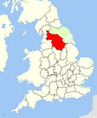
The Heavy Woollen District is a region of textile-focused industrial development in West Yorkshire, England. It acquired the name because of the heavyweight cloth manufactured there from the early 19th century.

Staincross was a Wapentake (Hundred), which is an administrative division, in the historic county of the West Riding of Yorkshire. It consisted of seven parishes, and included the towns of Barnsley and Penistone
Skyrack was a wapentake of the West Riding of Yorkshire, England. It was split into upper and lower divisions and centred in Headingley, Leeds. The Lower Division included the parishes of Aberford, Bardsey, Barwick-in-Elmet, Kippax, Thorner, Whitkirk and part of Harewood, while the Upper Division included the parishes of Adel, Bingley, Guiseley and parts of Harewood, Ilkley and Otley.
Claro was a wapentake of the West Riding of Yorkshire, England. It was split into two divisions. The Upper Division included the parishes of Farnham, Fewston, Hampsthwaite, Kirkby Malzeard and Pannal and parts of Aldborough, Knaresborough, Otley, Little Ouseburn, Ripley, Ripon, Wetherby and Whixley, many of which formed exclaves. The Lower Division included the parishes of Allerton Mauleverer, Goldsborough, Hunsingore, Kirk Deighton, Kirkby Overblow, Leathley, Spofforth with Stockeld, Weston and parts of Addingham, Aldborough, Harewood, Ilkley, Kirk Hammerton, Otley, Ripley and Whixley.
Staincliffe, also known as Staincliff, was a wapentake of the West Riding of Yorkshire, England.

Sandal Magna or Sandal is a suburb of Wakefield, West Yorkshire, England with a population in 2001 of 5,432. An ancient settlement, it is the site of Sandal Castle and is mentioned in the Domesday Book. It is 2 mi (3.2 km) south from Wakefield, 8 mi (13 km) north of Barnsley. The Battle of Wakefield was fought here in the 15th century during the Wars of the Roses.

Agbrigg is a suburb of the city of Wakefield, West Yorkshire, England.

Morley Tunnel is a railway tunnel in West Yorkshire, England, situated between Morley and Batley railway stations on the Huddersfield line. From its northern end, it extends 3,369 yards (3,081 m), passing beneath Morley town centre, to its southern end.

Huddersfield bus station serves the town of Huddersfield, West Yorkshire, England.

Sitlington, historically Shitlington, was a township in the ancient ecclesiastical parish of Thornhill in the wapentake of Agbrigg and Morley in the West Riding of Yorkshire comprising the villages and hamlets of Middlestown, Netherton, Overton and Midgley. The h was dropped from Shitlington and Sitlington was adopted in 1929 with the approval of the county council. The population of the civil parish at the 2011 census was 5,963.
