Airedale, in conjunction with the Ribble Valley, provides low-altitude passes from Yorkshire to Lancashire through the Aire Gap. It is therefore an important transport route and was a strategically important area historically. [2]
This article is missing information about the history of Airedale between the Romans and the 18th and 19th centuries.(November 2024) |
The upper Aire valley was formed 12,000 years ago by a retreating glacier. A moraine formed in the Cononley area and the lake stretched as far north as Gargrave. Colonisation by man developed later on, especially during the Iron Age. The peoples that occupied the Aire Valley (and much of north eastern England) were called Brigantes by the Romans. [4]
Transport improved in the 18th and 19th centuries with the building of the Aire and Calder Navigation [5] and the Leeds and Liverpool Canal. [6] The railways arrived from the 1830s onwards and during the twentieth century the roads were vastly improved in the valley.
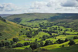
Airedale was wholly within the West Riding of Yorkshire until the reform of local government in 1974. [7]
The upper valley is within the Yorkshire Dales and Yorkshire Dales National Park. From Aire Springs the river flows past Skipton and Keighley, through Bingley, Saltaire, Shipley and into Leeds. Until this point the river is essentially swift flowing and fed by streams and becks.
The broad definition of Airedale includes all the areas adjacent to the River Aire and its tributaries. The Aire Catchment Flood Management Plan (CFMP), which takes into account all the becks and streams that feed the river, lists the Worth Valley and most of Bradford City as part of Airedale. [8] Similarly, the Airedale Partnership's Masterplan, which is sponsored by Bradford Council, shows the same boundaries as the Aire CFMP. [9]
The upper section between Malham and Skipton is largely upfaulted Carboniferous limestone. The middle section between Skipton and Knottingley is peat and gritstone, with steep valley walls crested with moorland prevalent between Skipton and Shipley. [10] The sandstone deposits between Skipton and Leeds have characterised the buildings within this part of Airedale, whilst the deposits of Limestone, Coal, Fireclay and Ironstone fuelled industrial developments. [11]
Airedale is notable for several tourist sites and the World Heritage Site of Saltaire village. [12] Other attractions include the Keighley and Worth Valley Railway, Bingley Five Rise Locks, the Shipley Glen Tramway, East Riddlesden Hall, Rodley Nature Reserve, Kirkstall Abbey, the Royal Armouries (Leeds), St Aidan's Nature Reserve and Fairburn Ings Nature Reserve.
Many of the former woollen and cotton mills of the dale have been demolished or converted into housing. The heavy industry east of Leeds is still in existence and two of the three coal fired powers stations in the lower section take their water from the River Aire. Industry that lies alongside the Aire includes Ferrybridge, [13] Eggborough and Drax power stations, Eggborough Saint Gobain glassworks, Stolze and Allied Glass in Knottingley and Kellingley Colliery.
Leeds City Council have an enterprise zone that covers 400 acres of regenerated land along the Aire Valley from the city centre up to junction 45 of the M1 (known as Gateway 45). This houses several manufacturing and food companies. [14]
The names Aire and Airedale are associated with many things and areas. Most notable in the valley are Airedale General Hospital, Aireborough [15] (a region comprising mostly Wharfedale towns) and Airedale, a suburb of Castleford.
The area gives its name to the Airedale Terrier, the largest of the terrier group of dogs. They were first bred in the area in the nineteenth century. [16]
Bingley is a market town and civil parish in the metropolitan borough of the City of Bradford, West Yorkshire, England. It is sited on the River Aire and the Leeds and Liverpool Canal. The town had a population of 18,040 at the 2021 Census.
The River Aire is a major river in Yorkshire, England, 92 miles (148 km) in length. Part of the river below Leeds is canalised, and is known as the Aire and Calder Navigation.
Riddlesden is a suburb of Keighley in the county of West Yorkshire, England and on the Leeds and Liverpool Canal.
Shipley is a historic market town and civil parish in the City of Bradford, West Yorkshire, England.
Craven was a non-metropolitan district in the west of North Yorkshire, centred on the market town of Skipton. The name Craven is much older than the modern district and encompassed a larger area. This history is also reflected in the way the term is still commonly used, such as by the Church of England.
Cross Hills is a village in the former Craven District of North Yorkshire, England, situated halfway between Skipton and Keighley. The village is at the centre of a built-up area that includes the adjoining settlements of Glusburn, Kildwick, Eastburn and Sutton-in-Craven. Cross Hills is the newer part of the civil parish now called Glusburn and Cross Hills, historically known as Glusburn.
Knottingley is a town in the City of Wakefield in West Yorkshire, England on the River Aire and the old A1 road before it was bypassed as the A1(M). Historically part of the West Riding of Yorkshire, it has a population of 13,503, increasing to 13,710 for the City of Wakefield ward at the 2011 Census. It makes up the majority of the Knottingley ward represented on Wakefield Council.
Bradford, also known as the City of Bradford, is a metropolitan borough in West Yorkshire, England. It is named after its largest settlement, Bradford, but covers a larger area which includes the towns and villages of Keighley, Shipley, Bingley, Ilkley, Haworth, Silsden, Queensbury, Thornton and Denholme. Bradford has a population of 528,155, making it the fourth-most populous metropolitan district and the ninth-most populous local authority district in England. It forms part of the West Yorkshire Urban Area conurbation which in 2011 had a population of 1,777,934, and the city is part of the Leeds-Bradford Larger Urban Zone (LUZ), which, with a population of 2,393,300, is the fourth largest in the United Kingdom after London, Birmingham and Manchester.
The Airedale line is one of the rail services in the West Yorkshire Metro area centred on West Yorkshire in northern England. The service is operated by Northern, on the route connecting Leeds and Bradford with Skipton. Some services along the line continue to Morecambe or Carlisle. The route covered by the service was historically part of the Midland Railway.
Kildwick, or Kildwick-in-Craven, is a village and civil parish of the district of Craven in North Yorkshire, England. It is situated between Skipton and Keighley and had a population of 191 in 2001, rising slightly to 194 at the 2011 census. Kildwick is a landmark as where the major road from Keighley to Skipton crosses the River Aire. The village's amenities include a primary school, church and public house.
Crossflatts is a ribbon development in Airedale along the old route of the A650 road between Bingley and Keighley, in the Metropolitan Borough of Bradford, West Yorkshire, England. The opening of the Aire Valley Trunk road in 2004 has seen a reduction of 51% of traffic through the village.
Shipley railway station serves the market town of Shipley in West Yorkshire, England. It is 2+3⁄4 miles (4.4 km) north of Bradford Forster Square and 10+3⁄4 miles (17.3 km) north-west of Leeds.
Frizinghall railway station is situated in the Frizinghall district of Bradford, West Yorkshire, England. It is an unstaffed halt on the Airedale Line, 2 miles (3 km) north of Bradford Forster Square. The station, and all trains serving it, are operated by Northern Trains.
Saltaire railway station serves the Victorian model village of Saltaire near Shipley in West Yorkshire, England. It is situated 3+1⁄2 miles (6 km) north of Bradford Forster Square.
Bingley is a grade II listed railway station that serves the market town of Bingley in West Yorkshire, England. It is located 13.5 miles (21.7 km) from Leeds and 5.5 miles (8.9 km) away from Bradford Forster Square, on the Airedale line; services are operated by Northern Trains.
The A650 road is a main route through the West Yorkshire conurbation in England. The road goes from Keighley to Wakefield on a rough north west/south east axis for 25 miles (40 km). The route is mostly single carriageway with some dualled sections in the Aire Valley, Bradford and the approach to Wakefield from the M1.
Thwaites railway station was located just east of Keighley, West Riding of Yorkshire, England; it was a stop on the Midland Railway line through the Aire Valley between Keighley and Shipley. It opened to traffic in 1892 and closed 17 years later in 1909, due to poor patronage.
Kildwick Bridge is a road bridge over the River Aire in North Yorkshire, England. It is one of the oldest documented bridges in England, with a reference dating back to 1305. It was the main route through Yorkshire to and from Skipton, later becoming part of the Keighley and Kendal Turnpike. A newer road bridge and bypass opened just upstream from the current bridge in 1988, however Kildwick bridge is still open to vehicular traffic gaining access to Kildwick village. The bridge is both a scheduled monument and a grade I listed structure.