The River Wharfe is a river in Yorkshire, England originating within the Yorkshire Dales National Park. For much of its middle course it is the county boundary between West Yorkshire and North Yorkshire. Its valley is known as Wharfedale.

Wharfedale is the valley of the upper parts of the River Wharfe and one of the Yorkshire Dales. It is situated in North Yorkshire, and the cities of Leeds and Bradford in West Yorkshire. It is the upper valley of the River Wharfe. Towns and villages in Wharfedale include Buckden, Kettlewell, Conistone, Grassington, Hebden, Bolton Abbey, Addingham, Ilkley, Burley-in-Wharfedale, Otley, Pool-in-Wharfedale, Arthington, Collingham and Wetherby. Beyond Wetherby, the valley opens out and becomes part of the Vale of York.

Malham Beck is a stream some 1.2 miles (2 km) long, running southwards through the valley beneath Malham Cove in the Yorkshire Dales, England. It originates in a cave beneath Malham Cove, and flows through Malham before joining Gordale Beck to become the River Aire just south of the village.

The River Swale in Yorkshire, England, is a major tributary of the River Ure, which becomes the River Ouse, that empties into the North Sea via the Humber Estuary. The river gives its name to Swaledale, the valley through which it flows.


Dalton-le-Dale is a small village in County Durham, in England. The parish population taken at the 2011 census was 1,546. It is situated on the old A19 road between Seaham and Murton. Most of the village is located in a wooded valley bottom, straddling a single road which follows the stream that runs through what is left of Cold Hesledon Dene. Where the road rises to meet the original path of the old A19, there is a small but very fine medieval church which is hidden from the old A19 in a dip. In the opposite direction where the village road to Seaham crosses the stream is Dalden Tower. The pele-tower is the most prominent part of the remains of what was a large medieval manor house complex. The site is a Scheduled Ancient Monument and the tower is Grade II* listed on the National Heritage List for England.
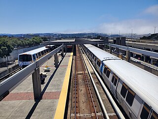
Daly City station is an elevated Bay Area Rapid Transit (BART) station in Daly City, California, just south of the city limits of San Francisco. It is adjacent to Interstate 280 and California Route 1, which it serves as a park-and-ride station.

Cringle Moor, at 432 m (1,417 ft), is the third highest hill in the North York Moors, England, and the highest point west of Clay Bank.

Wild Boar Fell is a mountain in the Yorkshire Dales National Park, on the eastern edge of Cumbria, England. At 2,323 feet (708 m), it is either the 4th-highest fell in the Yorkshire Dales or the 5th, depending on whether nearby High Seat (2,326 ft) is counted or not.

Ribblesdale is one of the Yorkshire Dales in England. It is the dale or upper valley of the River Ribble in North Yorkshire. Towns and villages in Ribblesdale include Selside, Horton-in-Ribblesdale, Stainforth, Langcliffe, Giggleswick, Settle, Long Preston and Hellifield. Below Hellifield the valley of the river is generally known as the Ribble Valley.

The River Hindburn is a river in Lancashire, England. The Hindburn rises at Thrushgill where three smaller streams combine. The river proceeds northwards past Lowgill to Wray where it merges with the River Roeburn before carrying on to meet the River Wenning in Hornby Park.

Tenkodogo is a department or commune of Boulgou Province in eastern Burkina Faso. Its capital is the town of Tenkodogo. According to the 2019 census the department has a total population of 157,947.

The Craven Fault System is the name applied by geologists to the group of crustal faults in the Pennines that form the southern edge of the Askrigg Block and which partly bounds the Craven Basin. Sections of the system's component faults which include the North, Middle and South Craven faults and the Feizor Fault are evident at the surface in the form of degraded faults scarps where Carboniferous Limestone abuts millstone grit. The fault system is approximately coincident with the southwestern edge of the Yorkshire Dales National Park and the northeastern edge of the Bowland Fells.

The Way of the Roses is the newest of Great Britain's coast-to-coast long-distance cycle routes and is based on minor roads, disused railway lines and specially constructed cycle paths. It lies entirely within the counties of Lancashire and Yorkshire, crossing the Yorkshire Dales and the Yorkshire Wolds in the North of England, passing through the historic cities of Lancaster and York and scenic towns and villages including Settle, Pateley Bridge and Ripon.

Kaempferol 7-O-glucoside is a flavonol glucoside. It can be found in Smilax china, and in the fern Asplenium rhizophyllum, and its hybrid descendants, as part of a complex with caffeic acid.

Brant Fell is a hill in the English Lake District, near Bowness-on-Windermere, Cumbria. It is the subject of a chapter of Wainwright's book The Outlying Fells of Lakeland. It reaches 629 feet (192 m). Wainwright's route leaves Bowness along the path of the Dales Way, makes an anticlockwise loop over the viewpoint of Post Knott to the summit, and either returns along the Dales Way or follows a woodland path to Helm Road from where another viewpoint, Biskey Howe, is only a slight detour before continuing down Helm Road to Bowness. He commends its "fine prospect of Windermere".
Upper Wharfedale School is a coeducational secondary school located in Threshfield, North Yorkshire, England. The school is named after Wharfedale, one of the Yorkshire Dales in which the school is located.
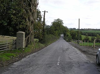
The R264 road is a regional road in Ireland, located in County Donegal in Ulster. It runs between Raphoe and Lifford. The road passes through the village of Ballindrait, where it crosses over the Burn Dale.
National Cycle Network (NCN) Route 688 is a Sustrans National Route that runs from Winterburn to Linton-on-Ouse. It is 55 miles (89 km), fully open and signed.