
Jervaulx Abbey in East Witton in North Yorkshire, 14 mi (23 km) north-west of the city of Ripon, was one of the great Cistercian abbeys of Yorkshire, England, dedicated to St Mary in 1156. It is a Grade I listed building.

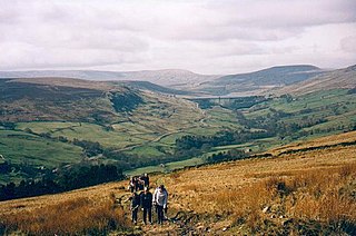
Wensleydale is a valley in North Yorkshire, England. It is one of the Yorkshire Dales, which are part of the Pennines. The dale is named after the village of Wensley, formerly the valley's market town. The principal river of the valley is the Ure, which is the source of the alternative name Yoredale. The majority of the dale is within the Yorkshire Dales National Park; the part below East Witton is within the national landscape of Nidderdale.
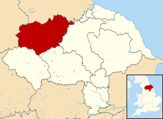
Richmondshire was a local government district of North Yorkshire, England, from 1974 to 2023. It covered a large northern area of the Yorkshire Dales including Swaledale and Arkengarthdale, Wensleydale and Coverdale, with the prominent Scot's Dyke and Scotch Corner along the centre. Teesdale lay to the north. With a total area of 1,319 km2, it was larger than seven of the English ceremonial counties.

The River Cover is a river in the Yorkshire Dales in North Yorkshire, England. The Yorkshire Dales Rivers Trust has a remit to conserve the ecological condition of the River Cover. The river forms a limestone dale with ancient woodlands.

Kettlewell is a village in Upper Wharfedale, North Yorkshire, England. Historically part of the West Riding of Yorkshire, it lies 6 miles (10 km) north of Grassington, at the point where Wharfedale is joined by a minor road which leads north-east from the village over Park Rash Pass to Coverdale. Great Whernside rises to the east. The population of the civil parish was 322 at the 2011 census, with an estimated population of 340 in 2015.

Swaledale is a valley in North Yorkshire, England. It is one of the Yorkshire Dales, which are part of the Pennines, and within the Yorkshire Dales National Park. It is named after the River Swale, which runs through it. Swaledale is the most northerly of the major dales.

The River Ure in North Yorkshire, England, is about 74 miles (119 km) long from its source to the point where it becomes the River Ouse. It is the principal river of Wensleydale, which is the only major dale now named after a village rather than its river. The old name for the valley was Yoredale after the river that runs through it.

Nidderdale, historically also known as Netherdale, is one of the Yorkshire Dales in North Yorkshire, England. It is the upper valley of the River Nidd, which flows south underground and then along the dale, forming several reservoirs including the Gouthwaite Reservoir, before turning east and eventually joining the River Ouse.
The Nidderdale National Landscape is an Area of Outstanding Natural Beauty in North Yorkshire, England, bordering the Yorkshire Dales National Park to the east and south. It comprises most of Nidderdale itself, part of lower Wharfedale, the Washburn valley and part of lower Wensleydale, including Jervaulx Abbey and the side valleys west of the River Ure. It covers a total area of 233 square miles (600 km2). The highest point in the Nidderdale AONB is Great Whernside, 704 metres (2,310 ft) above sea level, on the border with the Yorkshire Dales National Park.

Aysgarth is a village and civil parish in Wensleydale, in North Yorkshire, England. The village is in the Yorkshire Dales National Park, about 16 miles (26 km) south-west of Richmond and 22.6 miles (36.4 km) west of the county town of Northallerton.

Bainbridge is a village and civil parish in North Yorkshire, England. The population of the civil parish at the 2011 census was 480. The village is situated in the Yorkshire Dales National Park, near the confluence of the River Bain with the River Ure. It is 27+1⁄2 miles west of the County Town of Northallerton.
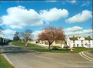
East Witton is a village and civil parish in Wensleydale in North Yorkshire, England. It lies south of Leyburn, in the Richmondshire district. Richard Whiteley is buried there; he and his partner, Kathryn Apanowicz, lived in the village.

West Scrafton is a village and civil parish in Coverdale in the Yorkshire Dales, England. It is located 4 miles (6.4 km) south west of Leyburn. It falls within the Richmondshire district of North Yorkshire. The population was estimated at 70 in 2013.

Coverham is a village in Coverdale in the Yorkshire Dales in North Yorkshire, England. It lies 2 miles (3.2 km) west of the town of Middleham.

Horsehouse is a village in Coverdale in the Yorkshire Dales, North Yorkshire, England. It is listed as a hamlet in many texts, but the presence of the church makes it a village. The River Cover runs near the village, and it lies some 6 miles (9.7 km) and 8.5 miles (13.7 km) south-west of Middleham and Leyburn respectively, at an elevation of 820 feet (250 m).

The A6108 road is an A road in North Yorkshire, England. It runs from the south of Scotch Corner to Ripon going via Richmond and Leyburn across the moors and the valleys of Swaledale and Wensleydale. The road is 37 miles (60 km) long, but through traffic between the two destinations will find a shorter route of 26 miles (42 km) by going south on the A1. The route is single carriageway for its entire length.
Coverham Abbey, North Yorkshire, England, was a Premonstratensian monastery that was founded at Swainby in 1190 by Helewisia, daughter of the Chief Justiciar Ranulf de Glanville. It was refounded at Coverham in about 1212 by her son Ranulf fitzRalph, who had the body of his late mother reinterred in the chapter house at Coverham.
Akarius Fitz Bardolph, Lord of Ravensworth, was the son of Bardolph, Lord of Ravensworth, an 11th-century nobleman living in Richmondshire, the area encompassing the Ure, Tees and Swale valleys in northern England. He was a sub-feudatory of Alan, Earl of Richmond. Akarius gave land at Fors in Wharfedale for the founding of a monastery in 1145. He died in 1161 and in 1165 his son, Harveus fitz Akarius, consented to the abbey being relocated to its permanent site. The abbey was relocated to the valley of the River Ure and was renamed the Abbey of Yore vale, which became Jervaulx Abbey. Akarius had a second son named William Bardolf.
The Six Dales Trail is a long distance footpath in North Yorkshire, England, with a short section in West Yorkshire. It is 38 miles (61 km) long and connects Otley and Middleham.

Kilgram Bridge is a crossing point across the River Ure in North Yorkshire, England. The bridge, which has six arches, is thought to date back to the 12th century, and it is thought that it is built on the old Roman ford crossing point of the river. Kilgram bridge is traditionally associated as being at the eastern and lower end of Wensleydale and is now a scheduled monument.


