River Cover

Last updated

River Cover
River Cover from St. Simons Bridge.jpg
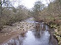
River Cover from St Simons Bridge
Location
Country England
Physical characteristics
Source 
  locationGreat Hunters Sleets nr Woodale
  coordinates 54°11′2″N2°1′29″W / 54.18389°N 2.02472°W / 54.18389; -2.02472
  elevation1,598 feet (487 m)
Mouth  
  location
River Ure nr Middleham
  coordinates
54°16′43″N1°46′25″W / 54.27861°N 1.77361°W / 54.27861; -1.77361 Coordinates: 54°16′43″N1°46′25″W / 54.27861°N 1.77361°W / 54.27861; -1.77361
  elevation
322 feet (98 m)
Length14 miles (22 km)

The River Cover is a river in the Yorkshire Dales in North Yorkshire, England. The Yorkshire Dales Rivers Trust [1] has a remit to conserve the ecological condition of the River Cover. The river forms a limestone dale with ancient woodlands. [2]

Contents

Course

The source of the river lies in the shake holes that are found between Buckden Pike and Great Whernside that feed many small gills, such as East Stone Gill, West Stone Gill and Downs Gill. Where these conjoined flows meet Hazel Bank Gill is where the river becomes known as the River Cover. It flows in a north-east direction past Woodale, Braidley and Horsehouse. It turns to the north north-east towards Gammersgill before returning north-east between West Scrafton and Carlton, North Yorkshire. Immediately east of Agglethorpe, the river turns east until it joins the River Ure south-east of Middleham. [3]

The river flows north eastwards for 14 miles (22 km) and drains an area covering over 20,130 acres (8,146 ha). [4] [5]

Ecology

The river is home for brown trout and grayling. [6]

Geology

The river runs along a U-shaped glacial valley over Great Scar limestone with Yoredale rock forming the valley sides. It is a gently meandering river with a characteristic stony channel and beaches leading to wooded low banks. The wooded areas extend up into the many gills that join the river. [2]

Lists

See also

Related Research Articles

<span class="mw-page-title-main">River Wharfe</span> River in Yorkshire, England

The River Wharfe is a river in Yorkshire, England originating within the Yorkshire Dales National Park. For much of its middle course it is the county boundary between West Yorkshire and North Yorkshire. Its valley is known as Wharfedale.

<span class="mw-page-title-main">River Ouse, Yorkshire</span> River in North Yorkshire, England

The River Ouse is a river in North Yorkshire, England. Hydrologically, the river is a continuation of the River Ure, and the combined length of the River Ure and River Ouse makes it, at 129 miles (208 km), the sixth longest river of the United Kingdom and the longest to flow entirely in one county. The length of the Ouse alone is about 52 miles (84 km) but the total length of the river is disputed.

<span class="mw-page-title-main">Pennines</span> Range of uplands in Northern England

The Pennines, also known as the Pennine Chain or Pennine Hills, are a range of uplands running between three regions of Northern England: North West England on the west, and North East England and Yorkshire and the Humber on the east. Commonly described as the "backbone of England", the range stretches northwards from the Peak District at the southern end, through the South Pennines, Yorkshire Dales and North Pennines to the Tyne Gap, which separates the range from the Border Moors and Cheviot Hills across the Anglo-Scottish border, although some definitions include them. South of the Aire Gap is a western spur into east Lancashire, comprising the Rossendale Fells, West Pennine Moors and the Bowland Fells in North Lancashire. The Howgill Fells and Orton Fells in Cumbria are sometimes considered to be Pennine spurs to the west of the range. The Pennines are an important water catchment area with numerous reservoirs in the head streams of the river valleys.

<span class="mw-page-title-main">Wharfedale</span> Valley in Yorkshire, England

Wharfedale is the valley of the upper parts of the River Wharfe and one of the Yorkshire Dales. It is situated within the districts of Craven and Harrogate in North Yorkshire, and the cities of Leeds and Bradford in West Yorkshire. It is the upper valley of the River Wharfe. Towns and villages in Wharfedale include Buckden, Kettlewell, Conistone, Grassington, Hebden, Bolton Abbey, Addingham, Ilkley, Burley-in-Wharfedale, Otley, Pool-in-Wharfedale, Arthington, Collingham and Wetherby. Beyond Wetherby, the valley opens out and becomes part of the Vale of York.

<span class="mw-page-title-main">Yorkshire Dales</span> Upland area of the Pennines in Northern England

The Yorkshire Dales is an upland area of the Pennines in the historic county of Yorkshire, England, most of it in the Yorkshire Dales National Park created in 1954.

Wensleydale Upper valley of the River Ure in North Yorkshire, England

Wensleydale is the dale or upper valley of the River Ure on the east side of the Pennines, one of the Yorkshire Dales in North Yorkshire, England.

<span class="mw-page-title-main">River Eden, Cumbria</span> River in Cumbria, England

The River Eden is a river that flows through the Eden District of Cumbria, England, on its way to the Solway Firth.

<span class="mw-page-title-main">River Swale</span> River in Yorkshire, England

The River Swale in Yorkshire, England, is a major tributary of the River Ure, which becomes the River Ouse, that empties into the North Sea via the Humber Estuary. The river gives its name to Swaledale, the valley through which it flows.

<span class="mw-page-title-main">Swaledale</span>

Swaledale is one of the northernmost dales (valleys) in Yorkshire Dales National Park, located in northern England. It is the dale of the River Swale on the east side of the Pennines in North Yorkshire.

<span class="mw-page-title-main">River Ure</span> River in North Yorkshire, England

The River Ure in North Yorkshire, England is approximately 74 miles (119 km) long from its source to the point where it becomes the River Ouse. It is the principal river of Wensleydale, which is the only major dale now named after a village rather than its river. The old name for the valley was Yoredale after the river that runs through it.

<span class="mw-page-title-main">Bainbridge, North Yorkshire</span> Village and civil parish in North Yorkshire, England

Bainbridge is a village and civil parish in the Richmondshire district of North Yorkshire, England. The population of the civil parish at the 2011 census was 480. The village is situated in the Yorkshire Dales National Park, near the confluence of the River Bain with the River Ure. It is 27.5 miles (44.3 km) west of the County Town of Northallerton.

<span class="mw-page-title-main">River Wiske</span> River in North Yorkshire, England

The River Wiske is a tributary of the River Swale in Yorkshire, England. The Wiske gives its name to several villages it passes through. The name Wiske is derived from an Old English word wisca meaning a water meadow. It was once known as the Foulbroke, a name for which some writers commented that it was well deserved.

<span class="mw-page-title-main">River Nidd</span> River in North Yorkshire, England

The River Nidd is a tributary of the River Ouse in the English county of North Yorkshire. In its first few miles it is dammed three times to create Angram Reservoir, Scar House Reservoir and Gouthwaite Reservoir, which attract a total of around 150,000 visitors a year. The Nidd can overflow the reservoirs, flooding the caves in the valley. In such cases the river overflows into the normally dry river bed past Lofthouse through to Gouthwaite Reservoir. The Yorkshire Dales Rivers Trust YDRT has a remit to conserve the ecological condition of the River Nidd from its headwaters to the Humber estuary.

<span class="mw-page-title-main">Hebden, North Yorkshire</span> Village and civil parish in North Yorkshire, England

Hebden is a village and civil parish in the Craven District of North Yorkshire, England, and one of four villages in the ecclesiastical parish of Linton. It lies near Grimwith Reservoir and Grassington, in Wharfedale in the Yorkshire Dales National Park. In 2011 it had a population of 246.

Coverdale (dale) Human settlement in England

Coverdale is a dale in the far east of the Yorkshire Dales, North Yorkshire, England. It takes its name from the River Cover, a tributary of the River Ure. The dale runs south-west from the eastern end of Wensleydale to the dale head at a pass, known as Park Rash Pass, between Great Whernside to the south and Buckden Pike to the north. It is accessible by a single track road, which runs the length of the dale and over the pass to Kettlewell in Wharfedale. The name is taken from that of the River Cover, which is of Brittonic origin. Ekwall suggested that it might mean "hollow stream", but more recently Andrew Breeze has argued that it is cognate with Welsh gofer "streamlet".

Topographical areas of Yorkshire

In Yorkshire there is a very close relationship between the major topographical areas and the geological period in which they were formed. The Pennine chain of Hills in the west is of Carboniferous origin. The central vale is Permo-Triassic. The North York Moors in the north-east of the county are Jurassic in age while the Yorkshire Wolds to the south east are Cretaceous chalk uplands. The plain of Holderness and the Humberhead levels both owe their present form to the Quaternary ice ages.

<span class="mw-page-title-main">River Burn, North Yorkshire</span> River in North Yorkshire, England

The River Burn is a river that flows wholly within North Yorkshire, England. The river starts as several small streams on Masham Moor and drains Colsterdale flowing eastwards before emptying into the River Ure just south of Masham. Conservation work on removinga weir and introducing fish to the river in 2016 has meant that salmon have been recorded spawning in the river for the first time in over 100 years.

<span class="mw-page-title-main">River Tutt</span> River in North Yorkshire, England

The River Tutt is a 8.7-mile (14 km) long tributary of the River Ure in North Yorkshire, England. The river rises near to the villages of Nidd and Scotton draining mainly arable land north eastwards before emptying into the Ure at Boroughbridge. Where the river joins the Ure in Boroughbridge, has been the site of significant historic flooding. An Environment Agency project to alleviate flooding on the river has seen diversion schemes and pumps added to prevent this.

<span class="mw-page-title-main">Wether Fell</span> Peak in the Yorkshire Dales, England

Wether Fell, also known as Drumaldrace, is a mountain in the Yorkshire Dales National Park, in North Yorkshire, England. Wether Fell is mountain that divides Wensleydale in the north and Upper Wharfedale in the south. Its summit is 614 metres (2,014 ft). A Roman Road, the Cam High Road, passes along the southern edge of the summit reaching 1,900 feet (580 m).

Cauldron Falls (North Yorkshire) Waterfall in North Yorkshire, England

Cauldron Falls, is a series of waterfalls on Walden Beck in the village of West Burton, North Yorkshire, England. It is known as Cauldron Falls due to the swirls in the plunge pools beneath the cascades of the waterfall. The beck continues on underneath a packhorse bridge where there is another cascade.

References

  1. "Yorkshire Dales Rivers Trust". www.yorkshiredalesriverstrust.org.uk. Retrieved 13 October 2011.
  2. 1 2 "Geology" (PDF). Archived from the original (PDF) on 24 December 2010. Retrieved 13 October 2011.
  3. "OpenData support | OS Tools & Support".
  4. "Coverdale Catch (Trib of Ure)". environment.data.gov.uk. Retrieved 24 September 2019.
  5. "Team goes against the flow". The Yorkshire Post. 22 October 2012. Retrieved 24 September 2019.
  6. "Ecology (Fish)" . Retrieved 13 October 2011.