Little Don River

Last updated

Little Don River
Little Don river. - geograph.org.uk - 497428.jpg
Little Don River near Langsett
Location
CountryEngland
Physical characteristics
Source 
  locationRushbed Moor
  coordinates 53°28′N1°46′W / 53.467°N 1.767°W / 53.467; -1.767
  elevation1,670 feet (510 m)
Mouth  
  location
River Don, Deepcar
  coordinates
53°28′38″N1°33′34″W / 53.47722°N 1.55944°W / 53.47722; -1.55944 Coordinates: 53°28′38″N1°33′34″W / 53.47722°N 1.55944°W / 53.47722; -1.55944
  elevation
430 feet (130 m)
Little Don River
BSicon uexKHSTaq.svg
BSicon uexSTRq.svg
BSicon uexSTR+r.svg
Sources of Loftshaw Brook
BSicon uexKHSTaq.svg
BSicon uexSTR+r.svg
BSicon uexSTR.svg
Sources of Little Don
BSicon uexKHSTaq.svg
BSicon uexABZg+r.svg
BSicon uexSTR.svg
BSicon uexABZg+l.svg
BSicon uexSTRr.svg
Loftshaw Brook
BSicon uexKHSTaq.svg
BSicon uexABZg+r.svg
BSicon uexKHSTa.svg
BSicon uexSTR.svg
BSicon uexKHSTa.svg
BSicon uexKHSTa.svg
BSicon uexKHSTaq.svg
BSicon uexABZql.svg
BSicon uexABZg+r.svg
BSicon uexSTR.svg
BSicon uexSTR.svg
Mickleden Beck
BSicon uexKHSTaq.svg
BSicon uexABZg+r.svg
BSicon uexSTR.svg
BSicon uexSTR.svg
Haslingshaw
BSicon uexABZg+l.svg
BSicon uexSTRr.svg
BSicon uexSTR.svg
Little Moor Beck
BSicon uexABZg+l.svg
BSicon uexSTRq.svg
BSicon uexSTRr.svg
Great Grain
BSicon uxWEIRg.svg
Weir
BSicon uexKHSTaq.svg
BSicon uexSTRq.svg
BSicon uexDOCKSa.svg
Thickwoods Brook
BSicon uexRESVGDa.svg
Langsett Reservoir
BSicon uexSKRZ-Eu.svg
Midhope Cliff Lane
BSicon uxWEIRg.svg
Spillway and weir
BSicon uexKHSTa.svg
BSicon uexSTR.svg
Shaw Brook
BSicon uexSTR.svg
BSicon uexABZg+l.svg
BSicon uexCONTfq.svg
Ochre Dike
BSicon uexRESVGr.svg
BSicon uexSTR+r.svg
BSicon uexSTR.svg
Midhope Reservoir
BSicon uexSTR.svg
BSicon uexSKRZ-Eu.svg
BSicon uexSTR.svg
Midhope Hall Lane bridge
BSicon uexSTR.svg
BSicon uexSTRl.svg
BSicon uexABZg+r.svg
Hagg Brook
BSicon uexKHSTe.svg
BSicon uexSTR.svg
Edge Cliff Brook
BSicon uxWEIRg.svg
Weir
BSicon uexSKRZ-Eu.svg
Midhopestones Bridge
BSicon uexKHSTaq.svg
BSicon uexSTRq.svg
BSicon uexDOCKSa.svg
Knoll Brook
BSicon uexRESVGDa.svg
Underbank Reservoir
BSicon uxWEIRg.svg
Spillway and weir
BSicon uexSKRZ-Eu.svg
Unsliven Bridge
BSicon uexSKRZ-Yu.svg
B6088 Bridge, Stocksbridge
BSicon uexSTR.svg
BSicon uextSTRa.svg
BSicon uextSTR.svg
Culvert under steelworks
BSicon uextSTRe.svg
BSicon uxmKRZu.svg
Railway to steelworks
BSicon uexSKRZ-Au.svg
A6102 Deepcar Bridge
BSicon uexSTR+l.svg
BSicon uexABZqr.svg
BSicon uexSTRq.svg
BSicon uexCONTfq.svg
River Don
BSicon uexCONTf.svg

The Little Don River also known as the Porter, is a tributary of the River Don in South Yorkshire, England. Arising on the Langsett Moors in the northern Peak District, the Little Don River feeds the Langsett and Underbank Reservoirs. It runs through the town of Stocksbridge before joining the River Don.

Contents

A 2.7-acre (1.1-hectare) section of the river has been designated as a site of special scientific interest since 1977. The site is of considerable importance as it is a proposed reference example for various subdivisions of the Carboniferous. [1] It is one of 35 sites of special scientific interest in South Yorkshire.

Course

The Little Don rises as a large number of streams flowing northwards from Howden Edge, close to the 1,640-foot (500 m) contour, on Rushbed Moor and Harden Moor, which unite and then flow eastwards. It is soon joined by Loftwshaw Brook, which similarly starts as a number of streams on Rushbed Moor, but slightly further to the west, and follows a more northerly route before joining the Little Don. It is joined by Mickleden Beck and Haslingshaw, both of which flow northwards and join the right bank. Long Moor Beck flows eastwards and joins as the Little Don enters Swinden Plantation, and the moorland scenery gives way to woodland. The river loops to the north, where it is joined by Great Grain, and passes over a weir to enter Langsett Reservoir. [2]

The reservoir was built as a join venture by the corporations of Sheffield, Doncaster, Rotherham and Barnsley. Sheffield Corporation bought the site in 1898 (or 1889 - sources vary) from the Pilkington family, and also purchased a number of local farms which were then abandoned, in order to prevent contamination of the water supply. Work started on constructing the dam, and the dams of Midhope and Underbank Reservoirs, further downstream, simultaneously, and Langsett Reservoir was completed in 1904. It was officially opened on 17 October, and held the largest volume of water of the dams constructed in the Sheffield area. [3] Transport of materials for the construction was aided by the Sheffield Corporation Railway, which ran along the north bank of the river from Stocksbridge. [4] The dam crossed the valley at the eastern end of the reservoir, and Midhope Cliff Lane ran along the top of it. A treatment works and filters were constructed below the dam, and a spillway to maintain flow in the river ran from the northern edge of the dam. [5] Ownership of the reservoir passed to the Yorkshire Water Authority in 1974, and following the passing of the Water Act 1989 and the privatisation of the water companies, it has been owned by Yorkshire Water. The reservoir covers 124 acres (50 ha), the earth embankment that forms the dam is 1,037 feet (316 m) long and a maximum of 115 feet (35 m) high, [6] and it impounds over 1,400 million imperial gallons (6,400 Ml) of water. [7] A new treatment works to replace those at Langsett and Midhope was constructed between 1983 and 1985, and can treat 60 Megalitres of water per day. It supplies drinking water to south-west Barnsley and north-west Sheffield. [6]

The Little Don entering the 36DD culvert at the western end of Stocksbridge steelworks. Little Don steelworks culvert.jpg
The Little Don entering the 36DD culvert at the western end of Stocksbridge steelworks.

A little further downstream, the Little Don is joined by Hagg Brook, a small stream that is fed by the overflow from Midhope Reservoir. There is another weir in the Little Don at Midhopestones, just before Midhopestones Bridge. [2] This small bridge carried Mortimer Road over the river, and is constructed of coursed gritstone blocks. It has three arches, a large one in the centre and a smaller one at either side. It dates from 1788 and is grade II listed. [8] Underbank Reservoir begins immediately below the bridge. While Langsett and Midhope reservoirs are used for water supply, Underbank provides compensation water for the Little Don and the Don. The volumes of water released were thought to be too high in 2017, as they had historically supplied the many industrial sites further down the Don. [9] There is a spillway from the southern edge of the dam with a weir at the bottom, after which the river is crossed by Unsliven Bridge. [2] A bridge was mentioned at this location in a charter which pre-dates 1290. The bridge that now stands there was erected around 1730, with a main arch and a smaller arch in the north abutment. It formed part of the route between Bradfield and Wakefield, on which traffic increased significantly during the industrial revolution. It was widened twice in the 18th century, and by 1796 was twice as wide as it had been. The northern approach was realigned in 1805, when the bridge became part of the Langsett, Wadsley, and Sheffield Turnpike. A toll bar was erected near the bridge, but was removed in 1838 when the Turnpike was repealed by Act of Parliament. The road to the north of the bridge was realigned as part of the work to build the reservoir dam. It has only been used by local traffic since the Manchester Road was moved further to the north. [10]

The next bridge downstream carries the B6088 road over the river. Below that the course used to meander across its flood plain, but had then been straightened as it ran past Stocksbridge gas works and the iron and steel works, where it fed a small reservoir. [11] By 1931, the steel works had extended much further up the valley, taking over the gas works site, and the river had been diverted into a new channel close to the B6088 road. In parts, it had been culverted, [12] and as the steelworks has expanded, more of it has been diverted into culverts. The culverts are long and large with some short open-air sections, and are known as 36DD by the urban exploring community, probably because both Samuel Fox, the originator of the steel works, and the model Samantha Fox were known as Sam Fox. [13] There is also a small section of culvert below the Fox Valley shopping centre. After emerging into the open again, it is crossed by the Stocksbridge Railway, which runs from Deepcar railway station into the steelworks. It was originally a subsidiary of Samuel Fox and Company but since 1992 it has been owned by the steelworks. It opened on 14 April 1877, and passenger services, which were mainly used by workers at the steelworks and pupils from Penistone Grammar School, ran until 1931. [14] The final bridge carries the A6102 into Deepcar, after which the river flows into the left bank of the River Don. [2]

Environment

The Environment Agency measure the water quality of the river systems in England. Each is given an overall ecological status, which may be one of five levels: high, good, moderate, poor and bad. There are several components that are used to determine this, including biological status, which looks at the quantity and varieties of invertebrates, angiosperms and fish, and chemical status, which compares the concentrations of various chemicals against known safe concentrations. Chemical status is rated good or fail. [15]

The water quality of the Little Don River system, which includes the Hagg Brook, was as follows in 2019.

SectionEcological StatusChemical StatusOverall StatusLengthCatchmentChannel
Little Don from Source to River Don [16] Moderate Fail Moderate 7.9 miles (12.7 km)17.71 square miles (45.9 km2)heavily modified

The river system has not been classed as good quality because of sewage discharges and physical modification of the channel, which restricts the movement of fish. Like many rivers in the UK, the chemical status changed from good to fail in 2019, due to the presence of polybrominated diphenyl ethers (PBDE), perfluorooctane sulphonate (PFOS) and mercury compounds, none of which had previously been included in the assessment.

The weir above Langsett Reservoir prevented migration of trout prior to the construction of a fish pass. Little Don - geograph.org.uk - 109854.jpg
The weir above Langsett Reservoir prevented migration of trout prior to the construction of a fish pass.

As well as barriers to the movement of fish, the river has also been affected by pollution from minewater and by the presence of the invasive species, the New Zealand mud snail. Pollution from minewater has been significantly reduced following the construction of a treatment plant by the Coal Authority. This is located between Langsett and Underbank reservoirs, and the minewater is pumped through it. There is a small amount of minewater which does not get processed by the plant, and a solution for this is being trialled by the Environment Agency, Yorkshire Water, and Highways England. In 2017, Yorkshire Water were assessing the amount of water discharged from the reservoirs into the river, with a view to altering them to more natural levels. Consideration has also been give to removing weirs, or providing fish passes where this is not reasonable. The provision of fish passes around the reservoir dams is not considered to be cost-effective, but installing one on a weir used for industrial water supply on the lower reaches of the river would increase the length of the Little Don accessible to fish from the Don twofold. [17] Another fish pass, just above Langsett Reservoir, enables trout and other fish which were impounded within the reservoir to travel some 3.1 miles (5 km) further upstream. [18] It allows them to negotiate the weir, which was installed to trap gravel before the Little Don entered the reservoir. The fish pass is of the Larinier type, and construction was completed on 19 April 2018. [19]

Prior to the pass being constructed, Yorkshire Water funded a research project, [20] which involved implanting passive integrated transponder tags into fish, and then using fixed telemetry equipment to detect the movement of fish both upstream and downstream across the weirs. [21] Fish from the reservoir were tagged, as were fish from the upper Little Don and Thickwoods Brook. Migration in both tributaries was thought to be impeded, as both have a weir just upstream from the reservoir. [22] In order to provide control data, similar monitoring was carried out at Grimwith Reservoir in North Yorkshire where there are two tributaries with no weirs. The study showed that there was no detectable movement from the reservoir into the tributaries, and less than expected in the downstream direction. This research informed the decision to construct the fish pass on the Little Don. [23]

Bibliography

Related Research Articles

River Don, Yorkshire River in South Yorkshire and the East Riding of Yorkshire, England

The River Don is a river in South Yorkshire and the East Riding of Yorkshire, England. It rises in the Pennines, west of Dunford Bridge, and flows for 70 miles (110 km) eastwards, through the Don Valley, via Penistone, Sheffield, Rotherham, Mexborough, Conisbrough, Doncaster and Stainforth. It originally joined the Trent, but was re-engineered by Cornelius Vermuyden as the Dutch River in the 1620s, and now joins the River Ouse at Goole. Don Valley is a UK parliamentary constituency near the Doncaster stretch of the river.

Porter Brook River in Sheffield, South Yorkshire, England

The Porter Brook is a river which flows through the City of Sheffield, England, descending over 1,000 feet (300 m) from its source on Burbage Moor to the west of the city to its mouth where it joins the River Sheaf in a culvert beneath Sheffield railway station. Like the other rivers in Sheffield, its steep gradient made it ideal for powering water mills and works associated with the metalworking and cutlery industries, and around 20 dams were constructed over the centuries to facilitate this. At its lower end, it is extensively culverted, but parts of it are gradually being restored to open channels, as part of a daylighting scheme for the city.

River Dearne River in South Yorkshire, England

The River Dearne South Yorkshire, England flows roughly east for more than 30 kilometres (19 mi), from its source just inside West Yorkshire. It flows through Denby Dale, Clayton West, Darton, Barnsley, Darfield, Wath upon Dearne, Bolton on Dearne, Adwick upon Dearne and Mexborough to its confluence with the River Don at Denaby Main. Its main tributary is the River Dove, which joins it at Darfield. The river was one of those affected by the 2007 United Kingdom floods.

Stocksbridge Town and civil parish in South Yorkshire, England

Stocksbridge is a town and civil parish, in the City of Sheffield, in South Yorkshire, England. Historically part of the West Riding of Yorkshire, it lies just to the east of the Peak District. The town is located in the steep-sided valley of the Little Don River, below the Underbank Reservoir. It blends into the areas of Deepcar, Bolsterstone and the eastern end of Ewden valley around Ewden village, which are also within the civil parish. The population of the civil parish as of the 2011 census was 13,455.

Bradfield, South Yorkshire Civil parish in South Yorkshire, England

Bradfield is a civil parish in the City of Sheffield, in South Yorkshire, England.

River Rother, South Yorkshire River in South Yorkshire, England

The River Rother, a waterway in the northern midlands of England, gives its name to the town of Rotherham and to the Rother Valley parliamentary constituency. It rises near Clay Cross in Derbyshire and flows in a generally northwards direction through the centre of Chesterfield, where it feeds the Chesterfield Canal, and on through the Rother Valley Country Park and several districts of Sheffield before joining the River Don at Rotherham in Yorkshire. Historically, it powered a number of mills, mainly corn or flour mills, but most had ceased to operate by the early 20th century, and few of the mill buildings survive.

River Loxley River in South Yorkshire, England

The River Loxley is a river in the City of Sheffield, South Yorkshire, England. Its source is a series of streams which rise some 10 miles (16 km) to the north-west of Sheffield on Bradfield Moors, flowing through Bradfield Dale to converge at Low Bradfield. It flows easterly through Damflask Reservoir and is joined by Storrs Brook at Storrs, near Stannington, and the River Rivelin at Malin Bridge, before flowing into the River Don at Owlerton, in Hillsborough. The Loxley valley provided the initial course of the Great Sheffield Flood, which happened after the Dale Dyke Dam collapsed shortly before its completion in March 1864.

Stocksbridge and Upper Don Electoral ward in the City of Sheffield, South Yorkshire, England

Stocksbridge and Upper Don ward is one of the 28 electoral wards of the borough of Sheffield, South Yorkshire, England. The population of this ward was 18,541 at the 2011 Census.

Blackburn Brook Stream in Sheffield, South Yorkshire, England

The Blackburn Brook is a stream in Sheffield, South Yorkshire, England which flows through the Blackburn Valley along the M1 and Ecclesfield Road and joins the River Don near the Meadowhall shopping centre. Downstream from the A61 road at Chapeltown the Blackburn Brook is defined as a main river by the Environment Agency, which requires new building development to be at least 26 feet (8 m) from the bank side as a flood defence measure and to allow access to the watercourse for maintenance.

Old Hay Brook

The Old Hay Brook is a small river in Sheffield, South Yorkshire, England. It is formed from the Redcar Brook, Blacka Dike and another stream, which rise on moors to the south of Sheffield, and is joined by Needham's Dyke near Totley Grange. At Totley Rise it joins Totley Brook, to become the River Sheaf. Water from the river was used to power mills processing lead, corn and paper from at least the 17th century, which were later used for grinding scythes as the Sheffield metal industry expanded. All the mills were defunct by 1900, although some remnants including weirs and dams are still visible.

Langsett Reservoir Reservoir in South Yorkshire, England

Langsett Reservoir is in Yorkshire, England, near the villages of Langsett and Upper Midhope, on the edge of the Peak District National Park. The reservoir was constructed between 1898 and 1904, and is now managed by Yorkshire Water. Fed by the Little Don or Porter River, it is around a mile long, and supplies water for Sheffield and Barnsley via the Langsett Treatment Works.

Stocksbridge Railway

The Stocksbridge Railway was a subsidiary of Samuel Fox and Company and linked the company's works at Stocksbridge, near Sheffield, South Yorkshire, England, with the main line of the Manchester, Sheffield and Lincolnshire Railway at Deepcar. As the size of Fox's steelworks expanded, better transport links were needed, and the railway was authorised by an Act of Parliament in 1874. It was completed in 1877, and remained an independent subsidiary until 1992, when it became part of the steelworks operation. When the Woodhead line was closed to the north of Deepcar, the line south to Sheffield was singled, and operates as a long siding.

A616 road Road in England

The A616 is a road that links Newark-on-Trent, Nottinghamshire, to the M1 motorway at Junction 30, then reappears at Junction 35A and goes on to Huddersfield, West Yorkshire.

River Hipper

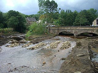
The River Hipper is a tributary of the River Rother in Derbyshire, England. Its source is a large expanse of wetlands, fed by the surrounding moors between Chatsworth and Chesterfield, known as the Hipper Sick on Beeley Moor, which is part of the Chatsworth Estate. It then passes through Holymoorside and down into Chesterfield, just south of the town centre, before flowing into the River Rother. In July 2007, parts of Chesterfield flooded when the River Hipper burst its banks during a substantial storm that caused extensive flooding in North Derbyshire and South Yorkshire.

River Drone

The River Drone is a river which flows south from its source on the Sheffield, South Yorkshire border. It flows through Dronfield, Unstone and Unstone Green in Derbyshire before merging at Sheepbridge to the north of Chesterfield with the Barlow Brook. Below the junction, it is often referred to as the River Whitting. It then flows south east till it merges with the River Rother at Brimington Road North (B6050) at Chesterfield. It is one of the three main tributaries of the Rother.

Midhopestones Village in South Yorkshire, England

Midhopestones is a village in the civil parish of Bradfield within the Stocksbridge and Upper Don electoral ward in the borough of the City of Sheffield, England.

Upper Midhope Village in South Yorkshire, England

Upper Midhope is a village in the civil parish of Bradfield within the Stocksbridge and Upper Don electoral ward in the borough of the City of Sheffield, England. It lies just on the edge of the Peak District national park.

Winscar Reservoir Reservoir in South Yorkshire, England

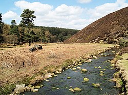
Winscar Reservoir, is a compensation reservoir on the headwaters of the River Don in South Yorkshire, England. The reservoir is located at Dunford Bridge, 25 miles (40 km) north west of Sheffield, and is just inside the Peak District National Park on the Pennine watershed. The reservoir was built on an existing dam and has suffered with leaking which necessitated a new membrane being installed at the dam head in the years 2000 and 2001.

Peak District Boundary Walk Long distance footpath in England

The Peak District Boundary Walk is a circular 190-mile (310 km) walking trail, starting and finishing at Buxton and broadly following the boundary of the Peak District, Britain's first national park. The route was developed by the Friends of the Peak District and was launched on 17 June 2017.

Fleet Brook River in northern Hampshire, England

Fleet Brook is a small river in northern Hampshire, England and tributary of the River Hart.

References

  1. "Little Don Stream Section" (PDF). Natural England . Retrieved 14 February 2009.
  2. 1 2 3 4 Ordnance Survey, 1:2500 map
  3. "Short history of Langsett". Langsett Parish Council. 10 March 2014. Archived from the original on 29 July 2021.
  4. Ordnance Survey, 1:2500 map, 1905
  5. Ordnance Survey, 1:2500 map, 1931
  6. 1 2 "Langsett in the Peak National Park". Peak District Education. Archived from the original on 1 September 2010.
  7. "Langsett Reservoir". Yorkshire Water. 2021. Archived from the original on 29 July 2021.
  8. Historic England. "Midhopestones Bridge (1192150)". National Heritage List for England . Retrieved 29 July 2021.
  9. EA 2017, p. 1.
  10. Historic England. "Unsliven Bridge, Stocksbridge (1444526)". National Heritage List for England . Retrieved 29 July 2021.
  11. Ordnance Survey, 1:2500 map, 1893
  12. Ordnance Survey, 1:2500 map, 1931
  13. Tarkovsky (30 May 2018). "Report - 36DD, Stocksbridge". 28 Days Later. Archived from the original on 21 February 2020.
  14. "Stocksbridge Railway Company". Stocksbridge & District History Society. 21 January 2011.
  15. "Glossary (see Biological quality element; Chemical status; and Ecological status)". Catchment Data Explorer. Environment Agency. Retrieved 15 May 2017.
  16. "Little Don from Source to River Don". Catchment Data Explorer. Environment Agency. Retrieved 27 July 2021.
  17. EA 2017, p. 2.
  18. EA 2017, p. 3.
  19. "Fish scale new heights on Little Don". Yorkshire Post. 20 April 2018. Archived from the original on 30 July 2021.
  20. Wallace 2017, p. 2.
  21. Wallace 2017, p. 35.
  22. Wallace 2017, p. 17.
  23. Wallace 2017, p. 3.

Commons-logo.svg Media related to Little Don River at Wikimedia Commons