Fox Hagg

Last updated

Entrance to Fox Hagg Entrance to Fox Hagg nature reserve - geograph.org.uk - 724007.jpg
Entrance to Fox Hagg

Fox Hagg is a small (33.25 hectares (82.2 acres)) nature reserve in the Rivelin Valley area of Sheffield, England. [1] The Allen Sike flows along the north edge of the reserve and the River Rivelin flows through the reserve from Rivelin Dams to the west. The Wyming Brook Nature Reserve borders Fox Hagg to the west. [2] The site is managed by the Wildlife Trust for Sheffield and Rotherham. [3]

Contents

Geology

The geology of the steep rocky hillside comprises sediments of sandstone, gritstone, mudstone conglomerates and impermeable shales, all dating from the Carboniferous period and indicative of a fluvial environment. Peat, formed in the Quaternary period, three million years ago, has been identified by the British Geological Survey. [4]

History

Permanent settlements were established during the Neolithic and Bronze Age with evidence of tree clearance indicating early agricultural exploitation of the land. During the Medieval Period agriculture continued into the valley bottom, with the steeper slopes being reserved for grazing. Walls erected in the post Medieval Era indicate land enclosure at that time. The area was once managed as a holly hagg, where the soft spikeless upper leaves of holly were cut for winter fodder for sheep and cattle. [1] The site is now managed to encourage wildlife and was designated as a local nature reserve in 2004. [4]

Wildlife

Birds

Birds identified at the nature reserve include yellowhammer, lesser redpoll, common linnet, willow tit, bullfinch, song thrush, meadow and tree pipits and wood warbler, dunnock (Prunella modularis), and common cuckoo. The Eurasian blackcap (Sylvia atricapilla), common  blackbird (Turdus merulus), and great tit (Parus major) are common at the reserve. Osprey (Pandion haliaetus) and lapwing (Vanellus vanellus) have been seen overflying the site. A number of species of high conservation concern, the song thrush and willow tit have been observed at the reserve. [4] [1]

Amphibians and reptiles

Common toads and viviparous lizards have been seen at the site. [4]

Mammals

A small mammal survey, carried out in 2005, indicated that voles, field mice and pygmy shrew lived at the reserve. Grey squirrel are known to inhabit the site. Roe deer are known to visit the reserve. [4]

Invertebrates

Two locally uncommon species of flies, Myopa buceata and Servillea ursine, are found at the site. The dead wood beetles, Triplax aenea and Orchesia undulata have been recorded at the nature reserve. The heather beetle (Lochmaea suturalis) is common. The moth, Coleophora vitisella, has been found at the site. The hoverfly, Cheilosia albipila and the orange tip butterfly (Anthocharis cardamines), favour the marshy conditions found at wetland locations within the reserve. [4]

Flora

Invasive species

Himalayan balsam ( Impatiens glandulifera ), an invasive species is controlled by strimming and hand pulling. In the past Asulox, a fern-specific herbicide, has been used on the site to reduce the amount of bracken at the reserve. Work to thin the wooded areas of the site have been funded by the Forestry Commission, as has the installation post and rail fence at the Lodge Lane car park. [5]

Broad-leaved woodland

The site has mixture of habitats, including broad-leaved woodland, which is dominated by oak, birch and rowan. Alder and willow are found in wetland areas of the reserve. [4]

Heathland

There are 4.8 hectares (12 acres) of heathland at the nature reserve. This is dominated by bilberry, with areas of bracken, bramble and wavy hair-grass. [4]

Facilities

The nature reserve is crossed by a number of public rights of way, including both footpaths and bridleways. [4] The reserve has parking for five vehicles at the Lodge Lane entrance to the site. Additional parking is available at the Rivelin Dams to the north west of the reserve. The condition of the site is monitored by Sheffield City Council as part of their Sheffield Local Biodiversity Action Plan. [6] [7] [8]

Artistic representation

The hillside at Fox Hagg, just below Lodge Moor, was painted in 1941 by Lionel Maurice de Sausmarez ARA. [9]

W. E. Smith depicted the valley from a vantage point at Bell Hagg, overlooking the reserve, c.1966. [10]

Related Research Articles

Five Weirs Walk

The 5-mile-long (8 km) Five Weirs Walk runs alongside the River Don in Sheffield, England. From Lady's Bridge in Sheffield City Centre, it heads downstream, northeast, over the Cobweb Bridge, through Attercliffe to Meadowhall.

River Rivelin River in South Yorkshire, England

The River Rivelin is a river in Sheffield, South Yorkshire, England.

Cotswold Water Park

The Cotswold Water Park is the United Kingdom's largest marl lake system, straddling the Wiltshire–Gloucestershire border, northwest of Cricklade and south of Cirencester. There are 180 lakes, spread over 42 square miles (110 km2).

Burngreave (ward) Electoral ward in the City of Sheffield, South Yorkshire, England

Burngreave ward—which includes the districts of Burngreave, Fir Vale, Grimesthorpe, Pitsmoor, and Shirecliffe—is one of the 28 electoral wards in City of Sheffield, England. It is located in the northern part of the city and covers an area of 2.8 square miles. The population of this ward in 2011 was 27,481 people in 9,906 households. It is one of the wards that make up the Sheffield, Brightside and Hillsborough constituency. Most of the ward is served by a free community newspaper, the Burngreave Messenger.

Camley Street Natural Park Urban nature reserve in Kings Cross in central London

Camley Street Natural Park is an urban nature reserve in King's Cross in central London and within the London Borough of Camden. It is a local nature reserve.

Ashford Green Corridor is a green space that runs through the town of Ashford in Kent, England. The Green Corridor is made up of parks, recreation grounds and other green spaces alongside the rivers that flow through Ashford. It is a Local Nature Reserve.

Brandon Marsh nature reserve Nature reserve in Warwickshire, England

Brandon Marsh is a Site of Special Scientific Interest (SSSI) and nature reserve in Warwickshire, England. It is situated adjacent to the River Avon, near the village of Brandon, a few miles east of Coventry.

Wyming Brook River in South Yorkshire, England

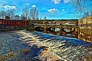
The Wyming Brook is a river in the City of Sheffield, England. Its source is the Redmires Reservoirs near the Hallam Moors. It flows in a north-easterly direction for over 0.6 miles (1 km) down quite steep terrain into an underground chamber where it joins the Rivelin tunnel before it flows into the lower of the Rivelin Dams. There is a path that runs alongside the brook which is popular with walkers. The path can be quite steep, with it and the brook falling over 100 m in a kilometre. The river flows almost its entire length within the Wyming Brook Nature Reserve, which is managed by the Wildlife Trust for Sheffield and Rotherham. The surrounds are wooded near the bottom and more open near the top, with stunning views of the Rivelin Valley and beyond. Wildlife found around Wyming Brook includes the dipper and the crossbill. The Peak District Boundary Walk runs through the nature reserve.

Fire Beacon Hill

Fire Beacon Hill is a Local Nature Reserve in East Devon, England. It is registered as Common land and known as Harpford Common. Sidmouth Town Council are the current owners, and are responsible for the management of the site.

Rowley Green Common

Rowley Green Common is a six hectare Local Nature Reserve and a Site of Importance Metropolitan for Nature Conservation in Arkley, north London. It is owned by the London Borough of Barnet and according to the Natural England details page it is jointly managed by the Hertfordshire and Middlesex Wildlife Trust and the London Wildlife Trust, but as of August 2015 it is not on the list of reserves of either Trust. It is also registered common land.

Gunnersbury Triangle A 2.57-hectare (6.4-acre) local nature reserve in the London boroughs of Ealing and Hounslow

Gunnersbury Triangle is a 2.57-hectare (6.4-acre) local nature reserve in the London boroughs of Ealing and Hounslow, immediately to the east of Gunnersbury. It was created in 1983 when, for the first time in Britain, a public inquiry ruled that a planned development of the land could not go ahead because of its value for nature. It opened as a nature reserve in 1985.

Cotterill Clough Nature Reserve

Cotterill Clough is a 5.6-hectare (14-acre) nature reserve near Manchester Airport. It is managed by the Cheshire Wildlife Trust and lies within a larger Site of Special Scientific Interest (SSSI). The Cotterill Brook, which flows through the reserve, is a tributary of the River Bollin. The reserve was purchased in 1934 by public subscription as a memorial to T. A. Coward (1867–1933), a famous Cheshire naturalist. It is 15 kilometres (9.3 mi) south of Manchester city centre and adjacent to Manchester Airport.

Portrack Marsh Nature Reserve

Portrack Marsh Nature Reserve is a 50 acres (20 ha) reserve by the northern bank of the River Tees between the Tees Barrage and the Tees Viaduct, near Portrack housing estate in Stockton-on-Tees borough, County Durham. It is the last remaining wetland on the lower Tees. The site is bounded by Marston Road, a disused railway line, the Northumbrian Water's waste water treatment site, the River Tees, the Tees Barrage White Water Course, the grounds of The Talpore pub and a Tees Barrage access road.

Clyde Valley Woodlands National Nature Reserve

The Clyde Valley Woodlands National Nature Reserve (NNR) comprises six separate woodland sites in the Clyde Valley region of South Lanarkshire, Scotland. These six sites are located along a 12 km section of the River Clyde and its tributaries, and lie close to built-up areas such as Hamilton and Lanark on the southern outskirts of Greater Glasgow. The sites can be easily accessed by about two million people living in the surrounding urban areas, making the reserve unique amongst Scotland's NNRs, most of which tend to be located in more remote areas. The six sites are:

Sheffield and Rotherham Wildlife Trust is a wildlife trust covering Sheffield and Rotherham, South Yorkshire, England. It has 15 reserves with its base in Sheffield.

Bull Cross, The Frith and Juniper Hill 42.33 ha biological and geological Site of Special Scientific Interest in Gloucestershire, notified in 1954

Bull Cross, The Frith and Juniper Hill is a 42.33-hectare (104.6-acre) biological and geological Site of Special Scientific Interest in Gloucestershire, notified in 1954. The site is listed in the ‘Stroud District’ Local Plan, adopted November 2005, Appendix 6 as an SSSI and Regionally Important Geological Site (RIGS).

Woorgreens Lake and Marsh

Woorgreens Lake and Marsh is a 9-hectare (22-acre) nature reserve in Gloucestershire.

Wigpool

Wigpool is a 7.5-hectare (19-acre) nature reserve in Gloucestershire in the Forest of Dean, England.

Magor Marsh

Magor Marsh is a 36-hectare (90-acre) wetland reserve, located on the Welsh side of the Severn Estuary. It is managed by the Gwent Wildlife Trust. It has a great variety of habitats, including damp hay meadows, sedge fen, reed bed, scrub and wet woodland. There are also numerous reens and a large pond.

Shepperlands Farm

Shepperlands Farm is a 10-hectare (25-acre) nature reserve north-west of Finchampstead in Berkshire. It is managed by the Berkshire, Buckinghamshire and Oxfordshire Wildlife Trust.

References

  1. 1 2 3 "Fox Hagg | Reserves". Sheffield & Rotherham Wildlife Trust. Retrieved 30 November 2020.
  2. "Fox Hagg and Rivelin Lower Reservoir". AllTrails.com. Retrieved 30 November 2020.
  3. Trust, Woodland. "Fox Hagg Nature Reserve". Woodland Trust. Retrieved 30 November 2020.
  4. 1 2 3 4 5 6 7 8 9 "Management Plan for Fox Hagg Nature Reserve" (PDF). Sheffield & Rotherham Wildlife Trust. 2 December 2020. Archived (PDF) from the original on 2 December 2020. Retrieved 2 December 2020.
  5. "Reserve Advisory Group meeting –Wyming Brook & Fox Hagg Nature Reserves Thursday 5th February 2015" (PDF). Sheffield & Rotherham Wildlife Trust. 5 February 2015. Archived (PDF) from the original on 2 December 2020. Retrieved 2 December 2020.
  6. "Biodiversity conservation in Sheffield". Sheffield City Council. 2 December 2020. Archived from the original on 2 December 2020. Retrieved 2 December 2020.
  7. "Heathlands Habitat Action Plan Target Sites" (PDF). Sheffield Local Biodiversity Action Partnership. 2 December 2020. Archived (PDF) from the original on 2 December 2020. Retrieved 2 December 2020.
  8. "Heathland Habitat Action Plan" (PDF). Sheffield Local Biodiversity Action Partnership. 2 December 2020. Archived (PDF) from the original on 2 December 2020. Retrieved 2 December 2020.
  9. "Lodge Moor, Sheffield, in the Evening | Art UK". artuk.org. Retrieved 2 December 2020.
  10. "Rivelin Valley, Sheffield | Art UK". artuk.org. Retrieved 2 December 2020.

Coordinates: 53°22′30″N1°34′41″W / 53.375°N 1.578°W / 53.375; -1.578