River Rivelin

Last updated

River Rivelin
River Rivelin at Walkley Bank Tilt.jpg
The river at the site of Walkley Bank Tilt.
Location
Country England
Physical characteristics
Source 
  location Pennines
Length8 miles (13 km)

The River Rivelin is a river in Sheffield, South Yorkshire, England.

Contents

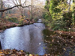
It rises on the Hallam moors, in north west Sheffield, and joins the River Loxley (at Malin Bridge). The Rivelin Valley, through which the river flows, is a 3+12-mile-long woodland valley which includes the popular Rivelin Valley Nature Trail that was created in 1967. The valley has farmland on its gentler upper slopes. Tributaries include the Wyming Brook, Allen Sike and the Black Brook. The Rivelin Dams are to be found at the head of the valley.

A relatively fast-flowing river (it drops 80 metres between Rivelin Mill Bridge and Malin Bridge), the Rivelin is fed by a constant release of water from the nearby moorland peat. Its flow was exploited for centuries as a power source, driving the water wheels of up to twenty industries (forges, metal-working and flour mills) along its course.

History

Roman times

There is evidence of Roman occupation of the area which comes from tablets found in April 1761 on the Stannington side of the Rivelin Valley which record the granting of land to retiring Roman auxiliaries of the Sunuci tribe. Other evidence of Roman occupation comes from finds on Walkley Bank Road, which leads onto the ridge facing Stannington. [1] [2] [3]

Medieval times

In medieval times the Rivelin valley was part of a large tract of land set aside by the Lords of Hallamshire for deer hunting. It was known as Rivelin Chase or Firth and covered thousands of acres on the western upland outskirts of the parish of Sheffield. In 1637 John Harrison after surveying the area declared that the firth had an area of 6,863 acres (2,777 ha). 5,531 acres (2,238 ha) of this was within Sheffield Parish with the rest in the Parish of Bradfield. [4] Until the 20th century the River Rivelin formed the north-western boundary of Sheffield.

Industrial past

The Valley possesses 21 artificially created ponds, testament to the twenty mills which were once present on the river. Though most of the mills and forges no longer exist, the ponds which used to feed them do, thanks to the support of the Rivelin Valley Conservation Group (RVCG) and Yorkshire Water. Some of the more famous mills (from west to east) are as follows:

Rivelin Corn Mill

The mostly westerly site, stands at the foot of Rails Road. This mill dates from 1600 when it was owned by Gilbert Talbot, 7th Earl of Shrewsbury. By 1830 there were two waterwheels powering three grinding stones, however problems with the water supply in the summer meant that the mill was often not working at full capacity. The mill continued operating until the 1930s after which the buildings quickly fell into disrepair and were demolished in the early 1950s [5] with a small car parking area now occupying the site. The dam wall was damaged in 1967 by dredging work and eventually collapsed in March 2001. The RVCG and Sheffield Council filled in the pond and created a new one nearby with a pond dipping platform. The official opening was on 17 May 2007. [6] [7]

The Wolf Wheel pond Rivelin Valley - River Rivelin Dam 01-05-06.jpg
The Wolf Wheel pond

Wolf Wheel

Was built around 1722 and had one of the largest wheels in the valley with a diameter of 15 feet (4.6 m). It was owned by the Windle brothers between 1818 and 1852 who used it for grinding knives and razors, after which it was sold to the Water Company. The mill was in regular use until 1918, but a survey in 1934 revealed that the internal machinery had been dismantled. [8] The pond that served the Wolf Wheel is still in fine condition and has received much attention from the RVCG. It is one of four dams that are used by fishermen in the valley and surrounding wildlife includes dragonflies such as the common darter Sympetrum striolatum and the common hawker, Aeshna juncea. Other wildlife includes kingfishers, great diving beetles and amphibians such as the common frog and palmate newt.[ citation needed ]

Hind Wheel Mill

This is oldest mill in the valley with a recorded date of 1581 when Thomas Hind, Robert Webster and John Swynden were the owners paying £1 per year rent. It was completely rebuilt around 1820 with production ceasing around 1930. In October 1936 "The Sheffield Daily Independent" reported that the building had completely disappeared. [9] The present day Round Pond which served the mill is one of the most popular in the area being stocked with trout for anglers; the surrounding area has a large variety of wildlife and there is a picnic area.

Nether Cut Wheel

Situated near the "S" bend on the A6101, the Nether Cut was the last mill to work in the valley; it was still grinding scythes until 1939 [10] and was not demolished until 1956. The mill suffered some unrest and damage during the Sheffield Outrages in 1874 for using non-union labour.

Cast iron marker at Walkley Bank Tilt, sadly vandalised. Walkley Bank Tilt marker.jpg
Cast iron marker at Walkley Bank Tilt, sadly vandalised.

Walkley Bank Tilt

This began as a mill making cutlery around 1750. From 1762 it was a tilt forge making farming tools before becoming a wire mill in 1901. In the 1920s it was converted to electrical power. It was one of the last mills in the valley to close as it was still working in the 1950s. [11] The area around the dam has been upgraded for recreational use with a small car park and bench seating. The dam is popular with anglers and has a large colony of waterfowl.

Mousehole Forge

Located close to Malin Bridge, the forge dates back to 1628 when it was known for iron smelting and bar production. However the forge became world-famous for producing anvils which were greatly commended and won a gold medal at The Great Exhibition of 1851. It is said that the anvil at Gretna Green was made by the Mousehole Forge. Production ceased in 1933 and part of the forge is now a private house.

Grogham Wheel

This was the last mill in the valley before the Rivelin's confluence with the River Loxley. It had two waterwheels, with the largest known as "Groggy" being the biggest in the valley. The mill ground files and cutlery and was the only one in the valley to be damaged by the Great Sheffield Flood due to the water backing up the valley. [12] The mill stopped production in 1933 with the buildings being demolished in August 1935 for public safety. [13]

Wildlife

The river valley is home to wildlife including mallard, the dipper, the kingfisher, the long-tailed tit, grey heron and the wren. [14] At Fox Hagg nature reserve on the south side of the river it is possible to see meadow and tree pipits, common redstarts and linnets and a number of warblers. [15]

Rivelin Valley Road

A long stretch of Rivelin Valley Road with its lime trees lining it. Rivelin Valley Road.jpg
A long stretch of Rivelin Valley Road with its lime trees lining it.

Rivelin Valley Road was built in 1907 between Malin Bridge and Rivelin Mill Bridge to connect with the main Sheffield to Manchester road, now the A57. Prior to this the valley had no road, just a series of cart tracks connecting the various industrial mills. The building of the road was proposed in 1905 by the local water board, which owned the land; the Duke of Norfolk also donated 4.5 hectares of his land in the area for the project. Work started in November 1905 and provided employment for 176 unemployed men. The unemployment rate was particularly high at the time and the opportunity to provide work was a contributing factor in making the decision to build the road. Raw materials for the construction of the road were provided by Clough Field quarry on the southern slopes of the valley below Crosspool. Over 700 lime trees were purchased from Dixon's of Chester in 1906 at a cost of £147. The limes were planted to line the road for a distance of 3.5 miles (5.6 km), making it the second longest lime tree avenue in Britain. [16] The road was opened on 1 September 1907, although work was not completed until June 1908. The final cost of construction was £30,000. Local people quickly christened the road "The New Road", a name which was still being used many years later. The success of the project in providing work for the unemployed prompted Sheffield Corporation to press ahead with plans to connect the new road with the Sheffield suburbs of Crookes and Walkley. Rivelin Valley Road is now designated as the A6101. [17]

The valley was especially loved by the "corn law rhymer" Ebenezer Elliott. There is a rock by the side of Black Brook with his name carved on it where he was renowned to sit and appreciate nature. Elliott wrote the lyrical poem "Farewell To Rivelin" in honour of the valley, with the lines:

Beautiful river! goldenly shining,
Where, with the cistus, woodbines are twining,
Birklands around thee, mountains above thee,
Rivelin wildest! Do I not love thee. [18]
The Rivelin public house. Rivelin Hotel 1.jpg
The Rivelin public house.

Landmarks

As well as industrial heritage, the valley is home to much wildlife, now protected by the Rivelin Valley Conservation Group. The upper part of the valley is flanked to the north by Rivelin Rocks. The rocks re-emerge three kilometres (2 miles) further down the valley above the Rivelin Hotel or "The Rivelin" on Tofts Lane. Behind the hotel is the Man's Head Rock, a once well known rock formation shown on many postcards, now hidden by mature trees. [19] [20] [21] [22] [23] [24] [25] This is the only public house in the rural part of the valley; the premises were formerly farm buildings before being converted into a pub. Another public house, the Holly Bush, is situated further down the valley, closer to Malin Bridge. One of the most distinguished buildings in the valley is the former King Edward VII Hospital, a Grade II listed building, the hospital closed in 1992 and has now been converted into apartments. St Michael's Cemetery, a Catholic burial ground is situated at the Malin Bridge end of the valley. Across the road from St. Michael's is the Rivelin Valley Park a small public recreation area which includes a cafe, playground and the Rivelin splash pools which were opened in July 2013 to replace the old outdated paddling pools.

Proposed flood defence scheme

In September 2014 Sheffield City Council announced plans to construct a dam wall in the valley at one of two possible locations, the Swallow/Wolf flood storage area or the Roscoe/New Dam flood storage area. After public consultation plans for the Swallow/Wolf flood storage area have since been dropped but the Roscoe/New Dam flood storage area remains as an option. [26] The dam will be over 36-foot (11 m) high with a 13-foot (4 m) wide crest. If the scheme goes ahead, it will reduce the depth of water downstream by 4 feet 11 inches (1.5 m) during heavy rain such as those that occurred in 2007 United Kingdom floods when parts of the city were flooded. [27] [28] [29] This proposal is likely to be highly controversial if goes ahead: the water retaining area would cover and potentially destroy or damage ancient and unique structures that are part of Sheffield's industrial heritage. It would also flood allotment gardens and would require the river course to change as well as to have the span of the valley that includes the nature trail covered by the dam embankment. The culvert (a concrete tunnel - maybe barred) to take the river may have to be as long as 70 metres.[ citation needed ] There is further debate about the contribution the Rivelin played in the floods of 2007 so the maths related to this scheme will be closely scrutinised by the very concerned public. (In the council consultation 60% of people expressing an opinion opposed this scheme - indeed it was the least popular area the council nominated).

Artistic representations

In the 1920s a group of artists founded a creative colony in the Rivelin Valley. They included Ben Baines, W R E Goodrich, Robert Scott-Temple and Vernon Edmonds. [30] A number of other artists are known to have worked in the Rivelin area.

Related Research Articles

<span class="mw-page-title-main">River Don, Yorkshire</span> River in South Yorkshire and the East Riding of Yorkshire, England

The River Don is a river in South Yorkshire and the East Riding of Yorkshire, England. It rises in the Pennines, west of Dunford Bridge, and flows for 69 miles (111 km) eastwards, through the Don Valley, via Penistone, Sheffield, Rotherham, Mexborough, Conisbrough, Doncaster and Stainforth. It originally joined the Trent, but was re-engineered by Cornelius Vermuyden as the Dutch River in the 1620s, and now joins the River Ouse at Goole. Don Valley is a UK parliamentary constituency near the Doncaster stretch of the river.

<span class="mw-page-title-main">River Sheaf</span> River in South Yorkshire, England

The River Sheaf in Sheffield, South Yorkshire, England, flows northwards, past Dore, through Abbeydale and north of Heeley. It then passes into a culvert, through which it flows under the centre of Sheffield before joining the River Don. This lower section of the River Sheaf, together with the River Don between the Blonk Street and Lady's Bridges, formed two sides of the boundary of Sheffield Castle.

<span class="mw-page-title-main">Hillsborough (ward)</span> Electoral ward in the City of Sheffield, South Yorkshire, England

Hillsborough is an electoral ward which includes the districts of Malin Bridge, Owlerton, Wadsley and Wisewood. It is one of the 28 electoral wards in City of Sheffield, England. It is located in the northwestern part of the city and covers an area of 4.6 km2. The population of this ward in 2011 was 18,605 people in 8,012 households.

<span class="mw-page-title-main">Porter Brook</span> River in Sheffield, South Yorkshire, England

The Porter Brook is a river which flows through the City of Sheffield, England, descending over 1,000 feet (300 m) from its source on Burbage Moor to the west of the city to its mouth where it joins the River Sheaf in a culvert beneath Sheffield railway station. Like the other rivers in Sheffield, its steep gradient made it ideal for powering water mills and works associated with the metalworking and cutlery industries, and around 20 dams were constructed over the centuries to facilitate this. At its lower end, it is extensively culverted, but parts of it are gradually being restored to open channels, as part of a daylighting scheme for the city.

<span class="mw-page-title-main">Great Sheffield Flood</span> March 1864 flood that devastated parts of Sheffield, England

The Great Sheffield Flood was a flood that devastated parts of Sheffield, England, on 11 March 1864, when the Dale Dyke Dam broke as its reservoir was being filled for the first time. At least 240 people died and more than 600 houses were damaged or destroyed by the flood. The immediate cause was a crack in the embankment, the cause of which was never determined. The dam's failure led to reforms in engineering practice, setting standards on specifics that needed to be met when constructing such large-scale structures. The dam was rebuilt in 1875.

<span class="mw-page-title-main">River Rother, South Yorkshire</span> River in South Yorkshire, England

The River Rother, a waterway in the northern midlands of England, gives its name to the town of Rotherham and to the Rother Valley parliamentary constituency. It rises near Clay Cross in Derbyshire and flows in a generally northwards direction through the centre of Chesterfield, where it feeds the Chesterfield Canal, and on through the Rother Valley Country Park and several districts of Sheffield before joining the River Don at Rotherham in Yorkshire. Historically, it powered mills, mainly corn or flour mills, but most had ceased to operate by the early 20th century, and few of the mill buildings survive.

<span class="mw-page-title-main">The Moss</span> River in England

The Moss is a brook in North East Derbyshire, England.

<span class="mw-page-title-main">River Loxley</span> River in South Yorkshire, England

The River Loxley is a river in the City of Sheffield, South Yorkshire, England. Its source is a series of streams which rise some 10 miles (16 km) to the north-west of Sheffield on Bradfield Moors, flowing through Bradfield Dale to converge at Low Bradfield. It flows easterly through Damflask Reservoir and is joined by Storrs Brook at Storrs, near Stannington, and the River Rivelin at Malin Bridge, before flowing into the River Don at Owlerton, in Hillsborough. The Loxley valley provided the initial course of the Great Sheffield Flood, which happened after the Dale Dyke Dam collapsed shortly before its completion in March 1864.

Malin Bridge is a suburb of the city of Sheffield, England. It is located at grid reference SK325893 and stands 2½ miles north-west of the city centre where the rivers Loxley and Rivelin meet. Malin Bridge is only a small district centred on the road bridge over the River Loxley which carries the B6076 road to Stannington ; it is surrounded by the suburbs of Hillsborough, Wisewood, Walkley and Stannington.

The Totley Brook is a stream in Sheffield, South Yorkshire, England. It rises on a millstone grit ridge some 7 miles (11 km) to the south-west of the centre of Sheffield. Over its course it drops from 740 feet (230 m) to 430 feet (130 m) near its junction with the Old Hay Brook close to Baslow Road. The streams form the River Sheaf once they have joined.

<span class="mw-page-title-main">Blackburn Brook</span> Stream in Sheffield, South Yorkshire, England

The Blackburn Brook is a stream in Sheffield, South Yorkshire, England which flows through the Blackburn Valley along the M1 and Ecclesfield Road and joins the River Don near the Meadowhall shopping centre. Downstream from the A61 road at Chapeltown the Blackburn Brook is defined as a main river by the Environment Agency, which requires new building development to be at least 26 feet (8 m) from the bank side as a flood defence measure and to allow access to the watercourse for maintenance.

<span class="mw-page-title-main">Old Hay Brook</span> River in Sheffield, England

The Old Hay Brook is a small river in Sheffield, South Yorkshire, England. It is formed from the Redcar Brook, Blacka Dike and another stream, which rise on moors to the south of Sheffield, and is joined by Needham's Dyke near Totley Grange. At Totley Rise it joins Totley Brook, to become the River Sheaf. Water from the river was used to power mills processing lead, corn and paper from at least the 17th century, which were later used for grinding scythes as the Sheffield metal industry expanded. All the mills were defunct by 1900, although some remnants including weirs and dams are still visible.

<span class="mw-page-title-main">West Hill Dam</span>

West Hill Dam Reserve is a United States Army Corps of Engineers flood control project with a recreational park and wildlife management area located at Uxbridge, Massachusetts. The West Hill Dam Project was completed in 1960. It is located on the West River, one of the branches of the Blackstone River which flows from Worcester, MA to Providence, RI. The West River originates in Grafton, Massachusetts, at Cider Mill Pond and Silver Lake, near Upton, Massachusetts, and the Upton State Forest. The dam is unusual in that it isn't filled unless there is a flood. West Hill Dam was built after devastating floods during the 1950s; it is intended to protect the Blackstone Valley from future destructive flooding. The cities and towns downriver from Uxbridge, including Millville, Blackstone, Woonsocket, North Smithfield, Cumberland, Lincoln, Central Falls, Pawtucket and Providence, Rhode Island, suffered extensive flooding from the Blackstone during Hurricane Diane in 1955. Hurricane Donna tested this new dam in 1960 as the eyewall passed over. The West Hill Dam is located in the Blackstone River Valley National Heritage Corridor near the Blackstone River and Canal Heritage State Park. Park rangers provide visitor assistance and offer scheduled interpretative programs. Fishing, hunting, and wildlife viewing opportunities are available year-round. The park has a recreation area, 34 picnic sites, one playground, a swimming area and five miles of hiking trails. However, access to the park from West Hill Road is currently blocked as of 2021 because of landowner disagreements. West Hill Dam is also the field office for the Charles River Natural Valley Storage Area. It consists of scattered wetlands in the upper and middle Charles River watershed, between the towns of Bellingham and Needham. The wetlands provide flood storage area, fisheries, wildlife management, and recreation. The Charles River is the well-known watercourse that flows into Boston Harbor.

<span class="mw-page-title-main">River Drone</span> River in Derbyshire, England

The River Drone is a river which flows south from its source on the Sheffield, South Yorkshire, border. It flows through Dronfield, Unstone and Unstone Green in Derbyshire before merging at Sheepbridge to the north of Chesterfield with the Barlow Brook. Below the junction, it is often referred to as the River Whitting. It then flows south-east till it merges with the River Rother at Brimington Road North (B6050) at Chesterfield. It is one of the three main tributaries of the Rother.

<span class="mw-page-title-main">Shire Brook</span> Waterway in South Yorkshire, England

Shire Brook is a small stream in the south eastern part of the City of Sheffield in South Yorkshire, England. It rises in the suburb of Gleadless Townend and flows in a general easterly direction for 4 miles (6.5 km) to its confluence with the River Rother between Beighton and Woodhouse Mill. In the past the brook has been both the border of Yorkshire and Derbyshire and between the sees of Canterbury and York. The course of the stream has been influenced by human intervention in the 20th century with the brook being diverted underground and flowing through culverts on three occasions as it traverses locations which were formerly landfill sites and extensive railway sidings.

<span class="mw-page-title-main">Little Matlock Rolling Mill</span> Rolling mill

Little Matlock Rolling Mill also known as Low Matlock Rolling Mill is a Grade II* Listed building situated on the River Loxley in the village of Loxley on the outskirts of the City of Sheffield, South Yorkshire, England. The building continues to operate as a rolling mill, owned and operated by Pro-Roll Ltd, a specialist hand rolling company. A brick building extension was added to the original 1882 structure in 1939.

<span class="mw-page-title-main">Rivelin Dams</span> Reservoirs in South Yorkshire, England

Rivelin Dams are a pair of water storage reservoirs situated in the upper part of the Rivelin Valley, 5 miles (8 km) west of Sheffield in South Yorkshire, England. The dams are owned by Yorkshire Water and provide water to 319,000 people as well as compensation water for the River Rivelin. They are named Upper and Lower and fall just within the eastern boundary of the Peak District.

<span class="mw-page-title-main">Rivelin Valley Park</span>

Rivelin Valley Park is a public recreation area in the Rivelin Valley area of Sheffield, England. The facilities consist of a playground and a small water park as well as a café. The park is situated on the Rivelin Valley Nature Trail, which is maintained by volunteers from the Rivelin Valley Conservation Group.

<span class="mw-page-title-main">Fulwood, Sheffield</span> Suburb of Sheffield in South Yorkshire, England

Fulwood is a residential suburb and ward of the City of Sheffield in England, it lies 5.5 km west-southwest of the city centre. Formerly an ancient settlement and village on the Porter Brook, it became integrated into the city in the 1930s. It is bounded by the suburbs of Lodge Moor to the NW, Ranmoor to the east and Crosspool to the NE. The open countryside of the Peak District lies to the west and SW. The sub districts of Stumperlowe and Goole Green are part of the suburb. The population of the ward at the 2011 Census was 18,233. Fulwood is located in the Sheffield Hallam constituency which, as of the 2019 general election voted Labour.

References

  1. Hunter, Joseph (1819). Hallamshire. The History and Topography of the Parish of Sheffield in the County of York. London: Lackington, Hughes, Harding, Mayor & Jones. (wikisource)
  2. Waddington, Clive (2012). "Discovery and Excavation of a Roman Estate Centre at Whirlow, South-west Sheffield" (PDF). www.archaeologicalresearchservices.com. Council for British Archaeology. Retrieved 28 March 2014.
  3. Taylor, M. V.; Collingwood, R. G. (1929). "Roman Britain in 1929: I. Sites Explored: II. Inscriptions". Journal of Roman Studies. Society for the Promotion of Roman Studies. 19 (2): 180–218. doi:10.2307/297347. JSTOR   297347.
  4. Hey, David. Historic Hallamshire. p. 98. ISBN   1-84306-049-3. Gives details of Rivelin Chase.
  5. Ball Crossley and Flavell, (2006), pp.83–84
  6. Sheffield City Council. Gives details of restoration work on Corn Mill.
  7. Rivelin Valley Conservation Group. Gives details of pond restoration.
  8. Ball Crossley and Flavell, (2006), pp.88–89
  9. Ball Crossley and Flavell, (2006), pp. 92–94
  10. Ball Crossley and Flavell, (2006), pp.97–98
  11. Ball Crossley and Flavell, (2006), pp.106–108
  12. Ball Crossley and Flavell, (2006), pp.111–113
  13. Kendall, Keith. Walking the Rivelin. Gives information on industry
  14. "Rivelin Valley Nature and Heritage Trail" (PDF). Rivelin Valley Conservation Group. Retrieved 2 December 2017.
  15. "Fox Hagg | Sheffield Wildlife Trust". www.wildsheffield.com. Retrieved 2 December 2017.
  16. Rivelin Valley Conservation Group. "over 700 lime trees lining the road making it the second longest lime tree avenue in Britain."
  17. "Old Ordnance Survey Maps – Sheffield (Rivelin Glen 1902)", Notes by Sylvia Pybus, ISBN   1-84151-179-X, gives details of Rivelin Valley Road.
  18. "Illustrated Guide to Sheffield", Pawson & Brailsford, ISBN   0-85409-671-X Page 185 gives information on Ebenezer Elliott.
  19. "Picture Sheffield". picturesheffield.com. Retrieved 21 May 2018.
  20. "Picture Sheffield". picturesheffield.com. Retrieved 21 May 2018.
  21. "Picture Sheffield". picturesheffield.com. Retrieved 21 May 2018.
  22. "Picture Sheffield". picturesheffield.com. Retrieved 21 May 2018.
  23. "Picture Sheffield". picturesheffield.com. Retrieved 21 May 2018.
  24. "Picture Sheffield". picturesheffield.com. Retrieved 21 May 2018.
  25. "Picture Sheffield". picturesheffield.com. Retrieved 21 May 2018.
  26. "Rivelin Valley Conservation Group". rivelinvalley.org.uk. Retrieved 2 December 2017.
  27. "Proposed Rivelin flood storage areas" (PDF).
  28. "Rivelin flood storage areas - Protecting Sheffield from Flooding". Archived from the original on 25 October 2017. Retrieved 12 May 2019.{{cite web}}: CS1 maint: unfit URL (link)
  29. "£55m flood scheme plans backed". BBC News. 17 September 2014. Retrieved 9 November 2017.
  30. "Picturing Sheffield: Rivelin Valley Artists". Museums Sheffield. Retrieved 2 December 2017.
  31. "Spooner's Wheel, Rivelin, Sheffield | Art UK" . Retrieved 2 December 2017.
  32. "Rivelin Valley, Sheffield | Art UK" . Retrieved 2 December 2017.
  33. "Rivelin Valley, Sheffield | Art UK" . Retrieved 2 December 2017.
  34. "Roscoe Wheel, Rivelin Valley, South Yorkshire | Art UK" . Retrieved 2 December 2017.
  35. "Rivelin Valley, near Black Brook, Sheffield | Art UK" . Retrieved 2 December 2017.
  36. "Interior of Holme Head Wheel, Rivelin Valley, Sheffield | Art UK" . Retrieved 2 December 2017.

Bibliography

  • Ball, Christine; Crossley, David; Flavell, Neville (2006). Water Power on the Sheffield Rivers: Second Edition. South Yorkshire Industrial History Society. ISBN   978-0-9556644-0-3.

Coordinates: 53°24′N1°30′W / 53.400°N 1.500°W / 53.400; -1.500