Winestead Drain

Last updated

Winestead Drain
Winstead Drain [1]
Winestead Fleet [2]
Patrington Channel
Patrington Channel on the River Humber - geograph.org.uk - 198718.jpg
Patrington Channel on the Humber Estuary. This is the rivermouth showing Winestead Outstrays pumping station
East Riding of Yorkshire UK relief location map.jpg
Red pog.svg
Location within the East Riding of Yorkshire
Location
County East Riding of Yorkshire
CountryEngland
Physical characteristics
Source 
  location Withernsea
  coordinates 53°43′41″N0°01′05″E / 53.728°N 0.018°E / 53.728; 0.018
  elevation10 metres (33 ft)
Mouth  
  location
Welwick Marsh
  coordinates
53°38′42″N0°01′08″E / 53.645°N 0.019°E / 53.645; 0.019 Coordinates: 53°38′42″N0°01′08″E / 53.645°N 0.019°E / 53.645; 0.019
  elevation
5 metres (16 ft)
Length15.5 kilometres (9.6 mi)
Basin size59.64 square kilometres (23.03 sq mi)
Basin features
EA waterbody IDGB104026066570

Winestead Drain is a small river in the East Riding of Yorkshire, England. The river flows south from Withernsea, around Patrington, before turning eastwards towards the Humber Estuary. The river was noted for being an inland waterway bringing shipping to the lower Humber reaches, though the river is now not navigable.

Contents

Historically the river emptied into the North Channel of the Humber just south of Patrington Haven. However, due to human intervention for drainage and flood prevention, the North Channel was cut off at the western end, and the installation of a sluice gate stopped the natural scouring of the channel by incoming and outgoing tides. This allowed the river to silt up making it unusable for watercraft.

Course

The river rises to the west of Withernsea between the B1242 and B1362 roads. The river drains a wide flat valley here with mostly alluvium on the surface. [3] It runs in a south-westerly direction towards Winestead, where a measuring station noted a record height of 3.38 metres (11.1 ft) in November 2000. [4] The river then curves to the south before picking up North Channel - the old body of water that separated Sunk Island from the rest of Holderness as part of the Humber Estuary - and then heads eastwards towards the Humber Estuary past Patrington Haven and its silted up access channel to the old port. [5] The river flows for 15.5 kilometres (9.6 mi) and drains an area of 55.6 square kilometres (21.5 sq mi). [6]

Welwick Saltmarsh Nature Reserve Welwick Saltmarsh Nature Reserve (geograph 5562249).jpg
Welwick Saltmarsh Nature Reserve

At the mouth of the river is a pumping station which was built in 1977. The station controls the flow of water between the river and the tidal estuary, preventing tidal waters from entering Winestead Drain. [7] On the eastern side of the river's mouth is Welwick Saltmarsh, a nature reserve covering 44 hectares (110 acres). [8] The pumping station, known as Winestead Outstrays, failed during the floods on 26 June 2007, when the river level reached a height of 2.42 metres (7 ft 11 in), its highest ever recorded. [9] Due to a re-alignment of sandbanks on the tidal Humber, the pumping station at the rivermouth is projected to move 750 metres (2,460 ft) inland upstream, and will incorporate an eel pass. [10]

The expansion of the intertidal wetlands will add 75 hectares (190 acres) of wet grassland to the land north of Winestead Drain. [11] The section of the river that flows across the mudflats of the estuary is Known as Patrington Channel, which is also a name used for the river as far upstream as the old port at Patrington Haven. [12] The banks of the drain have been raised on either side of the river due to the risk of tidal flooding from the Humber Estuary, with most of the hinterland either side of Winestead Drain being below the normal spring tide level. [13]

History

Up until the late seventeenth century, the water from Winestead Drain emptied into the Humber Estuary into what was called the North Channel; a body of water which was part of the Humber Estuary, but which flowed to the north of Cherry Cobb Sands and Sunk Island. Both Cherry Cobb and Sunk Island were saltmarshes covered by water at high tide, but were revealed at low tide. Human interference in the terms of artificial drainage and building up of sandbanks, meant that gradually, the North Channel became separated from the main stem of the estuary at its western end, and by 1850, the North Channel was a small drain feeding waters eastwards only and Sunk island and Cherry Cobb Sands had become fertile lands attached to the mainland of South Holderness. [14] This added a journey of 3.2 kilometres (2 mi) extra for shipping leaving Patrington Haven and reaching the Humber as the water now ran to the east in a narrower channel. [15] The result of the loss of flowing water, both incoming and outgoing tides, allowed the drain to silt up and eventually made the drain impassable to boats which used the small inlet to Patrington Haven. [16] The issue of the drainage over the reclaimed land prompted many Acts of Parliament being passed between 1764 and 1807, with the Winestead Drainage Act being passed in 1774. [17]

After siltation proved problematic in 1819, the Winestead Level Internal Drainage Board installed a clow (a type of sluice gate) on the lower part of the North Channel, and it became known as Winestead Drain instead of the North Channel. [18] In 1839, a novel method of clearing silt and maintaining the navigation was employed on the lower reaches of the drain. A machine known as a Floating Clough was positioned on the drain below where Patrington Haven entered the Winestead Drain. The machine was made of timber with various wooden projections sideways and longways which had serrated edges. It was allowed to sink on the incoming tide, and would then travel downstream with the outgoing tide maintaining the channel and "dressing the mud on the sides". The outgoing tidal force would maintain a dam behind the machine forcing it onwards for about 3 miles (4.8 km) down the drain. [19]

The problems of slow-moving or sluggish water in the drain had an effect on the lives of those living near to it in the 1860s. The Winestead Level Drainage Board notes for 1862 record that drinking water was poisoned, animals of the fields fell ill when drinking the water, and the stationmaster at Winestead noted that "the smell was so great to produce nausea all day, and for railway passengers to close the windows." [20]

Developments further upstream on the Humber have taken areas which were feeding grounds for wading birds such as the golden plover, curlew and redshank. As a result, over a 400 hectares (1,000 acres) of farmland at Skeffling and Sunk Island are being given over to intertidal wetlands. This will mean that the Winestead Drain will have a long southern edge against a new marsh wetland. [21] The South Holderness Internal Drainage Board objected to the defences being moved inland in 2019 as it will make the older pumping station inaccessible during times of flood. The original plan was to have no pumping facilities whatsoever. [22] The South Holderness Internal Drainage Board is responsible for maintaining parts of Winestead Drain, though historically, this was the responsibility of the Winestead Level Internal Drainage Board (IDB) until 2013. [23] [24]

Wildlife

The drain is covered by a conservation of wild birds directive. [25] Where the Winestead Drain meets the Humber is Welwick Saltmarsh, which is home to short-eared owl, hen harrier, peregrine falcon, and marsh harrier. Work has been undertaken to remove the banks around the southern side of Winestead Drain and create a new wetland, which will attract a similar variety of raptors as those listed already. [25] Otters were listed as being present on the beck in the 1960s, even as far north as Winestead village. [26] The waterbody has suffered low oxygen levels and has been exposed to phosphates and sediment, all of which are a problem for aquatic life. [27] [28] The middle section of the river takes on several smaller streams from both the east and the west, including one from Hollym which carries foul water, as there is no drainage for foul water at Hollym. [29]

Fishing is promoted on the drain with bream, roach, rudd and perch known to have been caught in the lower reaches. [30] [31] As part of the conversion of the bank of the Humber to new wetland status, fishing platforms were installed on the lower Winestead Drain. [21]

Shipping

In 1540, John Leland was travelling through the area, and described the port at Patrington Haven as "..a haven or creek for ships." [32] A map of Holderness from 1797, shows a small portion of the land known as Sunk Island being surrounded by saltmarshes, and Winestead Drain spilling into the saltmarsh directly via a watercourse known as North Channel. [33] Due the land reclamation of the saltmarshes which diverted Keyingham Drain and shortened the North Channel, Winestead Drain now extends eastwards towards the Humber, setting the port of Patrington Haven some 3 miles (4.8 km) north of the river, when before reclamation it was only 1.5 miles (2.4 km) distant. [34] [1] Those who used to bring fishing vessels up the creek into Patrington Haven, relocated their vessels to be berthed at Stone Creek, the mouth of Ottringham Drain after it was diverted. [34]

The mass turnpiking of the 18th century, brought favourable life to the port at Patrington Haven, when Sir Robert Hildyard, a local landowner, heavily invested in the road-building scheme from Patrington Haven to Hedon and Hull, which improved trade at the port for some time. [35]

In the early part of the 19th century, about 3,000 chaldrons of lime were being imported in Patrington Haven from the West Riding of Yorkshire. These were brought overland by a trade route that also carried goods to the West Riding from Patrington Haven. [36] Other commodities traded at the port included grain and corn sent to London, and coal imported from the West Riding. [37] [38] The board of Trustees was dissolved in 1865, and the last ship sailed on the Haven in 1867. [39]

A warehouse at the head of the navigation from the sea still exists and has partially been converted into a house. The minor tributary that fed into Winestead Drain from Patrington Haven was infilled c.1970. [40] [41] [42]

Related Research Articles

<span class="mw-page-title-main">Humber</span> Large tidal estuary in north-east England

The Humber is a large tidal estuary on the east coast of Northern England. It is formed at Trent Falls, Faxfleet, by the confluence of the tidal rivers Ouse and Trent. From there to the North Sea, it forms part of the boundary between the East Riding of Yorkshire on the north bank and North Lincolnshire on the south bank. Although the Humber is an estuary from the point at which it is formed, many maps show it as the River Humber.

<span class="mw-page-title-main">East Riding of Yorkshire</span> County and district in England

The East Riding of Yorkshire, or simply East Riding or East Yorkshire, is a ceremonial county and unitary authority area in the Yorkshire and the Humber region of England. It borders North Yorkshire to the north and west, South Yorkshire to the south-west, and Lincolnshire to the south.

<span class="mw-page-title-main">River Hull</span> River in the East Riding of Yorkshire, England

The River Hull is a navigable river in the East Riding of Yorkshire in Northern England. It rises from a series of springs to the west of Driffield, and enters the Humber Estuary at Kingston upon Hull. Following a period when the Archbishops of York charged tolls for its use, it became a free navigation. The upper reaches became part of the Driffield Navigation from 1770, after which they were again subject to tolls, and the section within the city of Hull came under the jurisdiction of the Port of Hull, with the same result.

Read's Island is an island situated just outside the Ancholme sluice, on the Humber Estuary in England. The Lincolnshire Trust suggest it is an artificial island, and a report from 1979 says that it was reclaimed. However, the site was for many years a large sandbank going by the name of "Old Warp" and is shown on the 1734 Customs Map of the Humber where Read's Island now lays, and extending further downstream.

<span class="mw-page-title-main">Holderness</span> Region of England

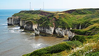
Holderness is an area of the East Riding of Yorkshire, on the north-east coast of England. An area of rich agricultural land, Holderness was marshland until it was drained in the Middle Ages. Topographically, Holderness has more in common with the Netherlands than with other parts of Yorkshire. To the north and west are the Yorkshire Wolds. Holderness generally refers to the area between the River Hull and the North Sea. The Prime Meridian passes through Holderness just to the east of Patrington and through Tunstall to the north.

<span class="mw-page-title-main">Paull</span> Village and civil parish in the East Riding of Yorkshire, England

Paull is a village and civil parish in Holderness, in the East Riding of Yorkshire, England, lying on the north bank of the Humber Estuary, east of the watercourse known as Hedon Haven.

<span class="mw-page-title-main">Patrington</span> Village and civil parish in the East Riding of Yorkshire, England

Patrington is a village and civil parish in the East Riding of Yorkshire, England, in an area known as Holderness, 9 miles (14 km) south-east of Hedon, 16 miles (26 km) south-east of Kingston upon Hull and 4 miles (6.4 km) south-west of Withernsea on the A1033. Along with Winestead, it was a seat of the ancient Hildyard/Hilliard/Hildegardis family.

<span class="mw-page-title-main">Adlingfleet</span> Village in the East Riding of Yorkshire, England

Adlingfleet is a drained, fertile, former marshland village in the East Riding of Yorkshire, England, that forms part of the civil parish of Twin Rivers. It is 6.5 miles (10.5 km) east-southeast of Goole town centre. Its sea wall along the far north-east is set back from the Ouse estuary leaving the largest single reedbed in England.

<span class="mw-page-title-main">Market Weighton Canal</span> Canal in the East Riding of Yorkshire, England

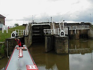
The Market Weighton Canal ran 9.5 miles (15.3 km) from the Humber Estuary to its terminus near Market Weighton. It gained its Act of Parliament in 1772 and opened in 1782. The 3.5 miles (5.6 km) closest to Market Weighton was abandoned in 1900 and the right of navigation through Weighton lock was lost in 1971. However, as of 2002 the lock was passable and the canal usable up to the junction with the River Foulness where silt has made it impassable. Also there is no right of navigation under the M62 motorway bridge to the north of Newport.

Sunk Island is a Crown Estate village and civil parish in the East Riding of Yorkshire, England. It lies 3+12 miles (6 km) south of Ottringham and 1 mile (1.6 km) to the north of the Humber Estuary. The Greenwich Meridian passes through the east of the parish.

<span class="mw-page-title-main">Patrington Haven</span> Hamlet in the East Riding of Yorkshire, England

Patrington Haven is a hamlet in the East Riding of Yorkshire, England, in an area known as Holderness. It is situated approximately 8 miles (13 km) south-east of the town of Hedon and 1 mile (1.6 km) south-west of the village of Patrington.

The Hull and Holderness Railway was a branch line in the East Riding of Yorkshire, England that connected the city of Kingston upon Hull with the seaside resort of Withernsea via the town of Hedon and the villages of Keyingham and Patrington.

<span class="mw-page-title-main">River Foulness</span> River in the East Riding of Yorkshire, England

The River Foulness is a river in the East Riding of Yorkshire, England. Its name is derived from Old English fūle[n] ēa, meaning “dirty water”. Maintenance responsibilities for the river transferred from the Environment Agency to the Market Weighton Drainage Board on 1 October 2011. Market Weighton Drainage Board subsequently amalgamated with the Lower Ouse Internal Drainage Board on 1 April 2012 to create the Ouse and Humber Drainage Board. The river discharges into the Humber Estuary via Market Weighton Canal. Water levels within the river, its tributaries and the canal are managed and controlled by the Environment Agency. The river lies in an area known as the Humberhead Levels.

<span class="mw-page-title-main">Holderness Drain</span> English water project

Holderness Drain is the main feature of a Land Drainage scheme for the area of Holderness to the east of the River Hull in the East Riding of Yorkshire, England. Construction began in 1764, and several notable civil engineers were involved with the scheme over the years. Despite the high costs of the initial scheme, it was not particularly successful, because of the refusal of the ship owners of Hull to allow an outlet at Marfleet. They insisted that the water be discharged into the River Hull to keep the channel free of silt. Following a period of agricultural depression and the building of new docks in the early 1800s, an outlet at Marfleet was finally authorised in 1832. A high level system still fed upland water to the Hull, but the low level system discharged into the Humber, where levels were considerably lower. Following the success of steam pumping on the Beverley and Barmston Drain, the trustees looked at such a possibility for the Holderness Drain, but the development of the Alexandra Dock in the 1880s and then the King George V Dock in 1913 provided a solution, as the docks were topped up with water pumped from the drain, to lessen the ingress of silt-laden water.

<span class="mw-page-title-main">Beverley and Barmston Drain</span> Drainage canal in East Riding of Yorkshire, England

The Beverley and Barmston Drain is the main feature of a land drainage scheme authorised in 1798 to the west of the River Hull in the East Riding of Yorkshire, England. The area consisted of salt marshes to the south and carrs to the north, fed with water from the higher wolds which lay to the north, and from inundation by tidal water passing up the river from the Humber. Some attempts to reduce the flooding by building embankments had been made by the fourteenth century, and windpumps appeared in the seventeenth century. The Holderness Drainage scheme, which protected the area to the east of the river, was completed in 1772, and attention was then given to resolving flooding of the carrs.

<span class="mw-page-title-main">Hedon Haven</span> River and port in the East Riding of Yorkshire, England

Hedon Haven is a waterway that connected the Humber Estuary with the port of Hedon, in Holderness, East Riding of Yorkshire, England. The waterway allowed ships to unload at the port in Hedon, which was also known as Hedon Haven and had, at its peak, three canalised arms that stretched into the town. The port at Hedon was the main port for south Holderness between the 12th and 13th centuries, and was the busiest port in Holderness before the docks at Hull were built.

<span class="mw-page-title-main">Swinefleet Warping Drain</span> Artificial waterway in the East Riding of Yorkshire, England

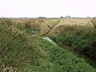
Swinefleet Warping Drain is an artificial waterway in the English county of the East Riding of Yorkshire, which was built to allow silt to be deposited on the peat moors, but now functions as a land drainage channel. It was constructed by Ralph Creyke, and the first section was completed in 1821.

<span class="mw-page-title-main">River Hull tidal surge barrier</span> A flood barrier in Kingston upon Hull, England

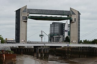
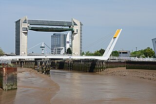
The River Hull tidal surge barrier is a flood control gate located on the River Hull in the city of Kingston upon Hull, in the East Riding of Yorkshire, England. The barrier impounds the river in times of tidal surges, preventing water moving upstream of the river from the Humber Estuary, and flooding the areas of the city which are near to the river, or susceptible to flooding. It is held horizontal when not in use, and turns 90 degrees before being lowered to the riverbed in the event of a tidal surge. It is the second largest flood barrier in the United Kingdom after the Thames Barrier in London.

<span class="mw-page-title-main">Skipsea meres</span> Former freshwater lakes in the East Riding of Yorkshire, England

The Skipsea meres were three lakes in and around the village of Skipsea in the East Riding of Yorkshire, England. The meres that are known to have existed were Skipsea Bail Mere, Skipsea Low Mere and Skipsea Withow Mere. The name of the village, Skipsea, means lake, or harbour for ships.

<span class="mw-page-title-main">Lagoon Hull</span> Proposed lagoon in the Humber Estuary, England

Lagoon Hull is a proposed £1.5 billion development on the Humber Estuary foreshore between Hessle and Kingston upon Hull, in the East Riding of Yorkshire, England. The proposed lagoon would be formed from a stone causeway and will provide an outer lock gate in the Humber Estuary which would effectively dam the River Hull, making it a non-tidal waterway. The 11-kilometre (6.8 mi) long causeway would also provide a dual carriageway from the A63 at Hessle which would run to Hull Docks, taking traffic away from the city centre. The scheme is being vaunted as one that will prevent future flooding in Hull when sea levels rise, and contribute to less flooding in the wider Humber Estuary.

References

  1. 1 2 Lythe 1938, p. 244.
  2. "Records of Winestead Level Drainage - Archives Hub". archiveshub.jisc.ac.uk. Retrieved 21 March 2023.
  3. Brigham, T.; Buglass, J.; George, R. (2009). "Yorkshire and Lincolnshire Volume 1 Bempton to Donna Nook: Part 1- Complete Report" (PDF). Rapid Coastal Zone Assessment Survey (235): 105. doi:10.5284/1000071.
  4. "Winestead Drain level upstream at Winestead Booster Pumping Station - GOV.UK". check-for-flooding.service.gov.uk. Retrieved 21 March 2023.
  5. Smith 1970, p. 26.
  6. "Winestead Drain from Source to Humber | Catchment Data Explorer | Catchment Data Explorer". environment.data.gov.uk. Retrieved 20 March 2023.
  7. Armstrong, W.; Wright, E. J.; Lythe, S.; Gaynard, T. J. (March 1985). "Plant Zonation and the Effects of the Spring-Neap Tidal Cycle on Soil Aeration in a Humber Salt Marsh". The Journal of Ecology. 73 (1): 324. doi:10.2307/2259786.
  8. "Welwick Saltmarsh | YWT". www.ywt.org.uk. Retrieved 20 March 2023.
  9. "Winestead Drain level at Patrington Haven Outstrays - GOV.UK". check-for-flooding.service.gov.uk. Retrieved 21 March 2023.
  10. "OUTSTRAYS TO SKEFFLING MANAGED REALIGNMENT SCHEME (OtSMRS) Construction Traffic Management Plan Summary, May 2021" (PDF). consult.environment-agency.gov.uk. p. 3. Retrieved 21 March 2023.
  11. "Major habitat creation project on the Humber to start this spring". GOV.UK. 25 February 2021. Retrieved 21 March 2023.
  12. Smith 1970, p. 10.
  13. "Hull and East Riding Consultation Report" (PDF). environmentdata.org. Environment Agency. p. 84. Retrieved 24 March 2023.
  14. Allison, K. J. (1976). The East Riding of Yorkshire landscape. London: Hodder & Stoughton. p. 174. ISBN   0340158212.
  15. "Humber Ferries Improvement". Hull Packet. No. 3291. Column D. 18 February 1848. p. 6.
  16. Sheppard 1966, pp. 4–8.
  17. Siddle 1962, p. 97.
  18. Sheppard 1966, p. 11.
  19. Ellis, G. (January 1839). "DESCRIPTION OF A MACHINE CALLED A FLOATING CLOUGH". Minutes of the Proceedings of the Institution of Civil Engineers. 1 (1839): 48. doi:10.1680/imotp.1839.24841.
  20. Siddle 1962, p. 194.
  21. 1 2 Wood, Alexandra (28 December 2018). "£20m wildlife reserve will give birds vital haven". The Yorkshire Post. p. 7. ISSN   0963-1496.
  22. Wood, Alex (4 August 2019). "New £30m plan for wildlife habitat around The Humber approved". The Yorkshire Post. Retrieved 21 March 2023.
  23. "Winestead Drain map" (PDF). southholdernessidb.co.uk. Retrieved 21 March 2023.
  24. "Home Page | South Holderness Internal Drainage Board". www.southholdernessidb.co.uk. Retrieved 24 March 2023.
  25. 1 2 CBA 2017, p. 31.
  26. Howes, Colin. "Changes in the status and distribution of mammals of the order Carnivora in Yorkshire from 1600. County history of the fox, badger, otter, pine marten, stoat, weasel, polecat, American mink, wildcat and domestic cat" (PDF). bradscholars.brad.ac.uk. p. 110. Retrieved 29 December 2022.
  27. CBA 2017, p. 32.
  28. "Outstrays to Skeffling Managed Realignment Scheme Environmental Statement: Non-Technical Summary" (PDF). consult.environment-agency.gov.uk. December 2018. p. 23. Retrieved 26 March 2023.
  29. "Hull and East Riding Consultation Report" (PDF). environmentdata.org. Environment Agency. p. 117. Retrieved 24 March 2023.
  30. "Floating fish spark tests for pollution" . infoweb.newsbank.com. 27 April 2001. Retrieved 26 March 2023.
  31. Fitzpatrick, Steve, ed. (9 February 2021). "Ten more small rivers to head to this week". The Angling Times. Peterborough: Bauer Media. p. 25. ISSN   0003-3308.
  32. Brockbank, James Lindow (1913). The East riding of Yorkshire. Oxford: Clarendon Press. p. 169. OCLC   1042922782.
  33. Lythe 1938, p. 245.
  34. 1 2 History & Directory of East Yorkshire, 1892. Preston: T. Bulmer & Co. 1892. p. 470. OCLC   1131686527.
  35. McMahon, Kenneth (1964). "Roads and Turnpike Trusts in Eastern Yorkshire". East Yorkshire Local History Series. York: East Yorkshire Local History Society (18): 25. OCLC   774672868.
  36. Strickland, H. E. (1812). A general view of the agriculture of the East-Riding of Yorkshire. York. p. 281. OCLC   31783993.
  37. Alexander et al 1990, p. 143.
  38. Duckham, Baron F. (1972). The inland waterways of East Yorkshire, 1700-1900. York: East Yorkshire Local History Society. p. 6. ISBN   0900349298.
  39. Peach, Howard (2001). Curious tales of old East Yorkshire. Wilmslow, England: Sigma Leisure. p. 147. ISBN   1850587493.
  40. "Georeferenced Maps - Map images - National Library of Scotland". maps.nls.uk. Retrieved 21 March 2023. Use the slider on the lower left to toggle between modern day imagery and old maps
  41. Alexander et al 1990, p. 143–144.
  42. Historic England. "House Adjoining to Rear of the Burn's Head Inn (Grade II) (1366248)". National Heritage List for England . Retrieved 21 March 2023.

Sources