
Thornbury is an area of Bradford, in West Yorkshire, England on the border with the City of Leeds. Thornbury is located in the Bradford Moor ward and the Bradford East parliamentary constituency. Thornbury is contiguous with Pudsey – part of the City of Leeds conurbation and borders Laisterdyke, and Fagley in Eccleshill ward.

Leeds North West is a constituency in the City of Leeds which has been represented in the House of Commons of the UK Parliament since 2017 by Alex Sobel, of Labour Co-op.

Skidby is a small village and civil parish in Yorkshire Wolds of the East Riding of Yorkshire, England. It is situated about 6 miles (10 km) north-west of Hull city centre, 2.2 miles (3.5 km) west of Cottingham and 5 miles (8 km) south of Beverley.

Bradford Moor is an electoral ward within the City of Bradford Metropolitan District Council. The population of the ward at the 2011 Census was 21,210. The ward includes the areas of Laisterdyke and Thornbury.
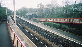
New Pudsey railway station serves the towns of Farsley and Pudsey in West Yorkshire, England, on the Calder Valley line. It serves the adjacent suburb of Thornbury.

West Beck is the common name given to the upper section of the old River Hull, as it rises in the foothills of the Yorkshire Wolds. After reaching Frodingham Beck at Emmotland, it becomes called the River Hull. It is noteworthy for being the most northerly chalk stream in England. It provides fly fishing for wild brown trout and grayling.

The Meanwood Beck is a stream in West Yorkshire, England, which flows southwards through Adel, Meanwood and Sheepscar into the River Aire in central Leeds. Different portions of the same watercourse have been referred to as Adel Beck, Carr Beck, Lady Beck, Mabgate Beck, Sheepscar Beck, Timble Beck or Wortley Beck. The Meanwood Valley Trail footpath follows the line of the beck for much of its course.

The River Calder is a major tributary of the River Ribble in Lancashire, England, and is around 20 miles (32 km) in length.

Pudsey Beck is a watercourse in West Yorkshire, England which borders Fulneck (Leeds) and Tong Village (Bradford). It forms the southern and eastern boundary of the area of Pudsey town, after which it is named, and continues as Farnley Beck along the northern edge of Farnley.

The Leeds Country Way is a circular long-distance footpath of 62 miles (99 km) around Leeds, West Yorkshire, England. It is never more than 7 miles (11 km) from City Square, Leeds, but is mainly rural with extensive views in the outlying areas of the Leeds metropolitan district. It follows public Rights of Way including footpaths, bridleways and minor lanes, with a few short sections along roads.

Leeds City bus station serves the city of Leeds, England. Owned and managed by West Yorkshire Metro, it is situated between the Quarry Hill and Leeds Kirkgate Markets areas of Leeds city centre. The National Express Dyer Street Coach Station adjoins the bus station.
Laisterdyke is an area of Bradford, West Yorkshire, England, situated to the east of the city on the border with City of Leeds and located in the Bradford Moor ward and in the Bradford East parliamentary constituency. Laisterdyke borders Barkerend, Bradford Moor area, Thornbury, Tyersal, and Bowling.

The Eller Beck is a small river in North Yorkshire, England, that flows through the town of Skipton and is a tributary of the River Aire. Its channel was heavily modified to supply water to mills in the 18th and 19th centuries, and although all the mills have closed, the water now supplies power to the National Grid, generated by a turbine at High Corn Mill. The beck flows through several underground culverts in Skipton that contribute to the flood risk. To alleviate flooding in Skipton town centre, a scheme involving two flood water storage reservoirs was designed and eventually completed in 2017.

Harden Beck is a stream that flows from Hewenden Reservoir, over Goit Stock Waterfall to the River Aire in Bingley, West Yorkshire. The route starts out further up the valley as Denholme Beck, Hewenden Beck and Hallas Beck. Its waters are fed by Thornton Moor Reservoir, Stubden Reservoir, Doe Park Reservoir and Hewenden Reservoir.
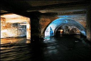
Bradford Beck is a river that flows through Bradford, West Yorkshire, England, and on to the River Aire at Shipley. As it reaches Bradford city centre it runs underground after being built over in the 19th century. It is culverted as it runs from Bradford city centre to Queen's Road after which it runs mostly in an open channel to Shipley. The beck used to be known as the filthiest river in England.
The Pudsey loop was a railway line in the former West Riding of Yorkshire, England, which served the town of Pudsey and later offered a second connection between Bramley in the east and Laisterdyke and Dudley Hill in the west, in addition to the existing line between Leeds and Bradford Exchange station.

Post Hill is a designated Leeds Nature Area on the western end of Farnley, and partly in Pudsey. It is situated mostly east of Pudsey Beck and Farnley Beck, between Wood Lane in the north and Troydale Lane in the south, and forms part of the West Leeds Country Park.

Holme Beck is a watercourse in the Tong ward of the City of Bradford, West Yorkshire, England. It drains a shallow valley east of the watershed between Bradford and Leeds. Holme Beck begins in the village with no evidence of any continuation on the other side of the canal or motorway. Holme Beck is the main carrier for village drainage, it runs beneath the West Coast Main Line and then through the large marsh area of Holme Moss before joining the River Bela.

Wyke Beck is a stream that runs from Roundhay Park to the River Aire in east Leeds, West Yorkshire, England. Described as an Urban Beck, the stream flows through housing estates and then an industrial landscape in its lower reaches. Wyke Beck has been prone to flooding so often, that remediation of its course and flood storage schemes have been initiated by Leeds City Council.
Oak Beck is a watercourse that flows eastwards across the northern part of Harrogate in North Yorkshire, England. The beck flows through a broad V-shaped valley, before emptying into the River Nidd at Bilton, just upstream from the Nidd Gorge Viaduct. Water from Oak Beck has been used as a water supply for Harrogate and also for industrial purposes further downstream.

