River Dove, Barnsley

Last updated

River Dove, South Yorkshire
River Dove Low Valley. - geograph.org.uk - 535049.jpg
River Dove on the outskirts of Darfield
Location
Country England
Physical characteristics
Source 
  location Worsbrough Reservoir
  coordinates 53°31′34″N1°28′27″W / 53.52611°N 1.47417°W / 53.52611; -1.47417
  elevation56 metres (184 ft)
Mouth  
  location
River Dearne nr Darfield
  coordinates
53°31′43″N1°22′9″W / 53.52861°N 1.36917°W / 53.52861; -1.36917 Coordinates: 53°31′43″N1°22′9″W / 53.52861°N 1.36917°W / 53.52861; -1.36917
Length4.92 miles (7.91 km)
River Dove
BSicon uexKHSTa.svg
BSicon uexKHSTa.svg
BSicon uexKHSTa.svg
BSicon uexSTR.svg
BSicon uexABZg+l.svg
BSicon uexSTRr.svg
BSicon uexSTRl.svg
BSicon uexABZg+r.svg
BSicon uexSTR.svg
Stainborough Dike
BSicon uexKHSTa.svg
BSicon uexSTR.svg
Crane Moor Dike
BSicon uexKHSTaq.svg
BSicon uexABZg+r.svg
BSicon uexSTR.svg
Rockley Dike / Stainborough Dike
BSicon uexSTR.svg
BSicon uexABZg+l.svg
BSicon uexKHSTeq.svg
Dodworth Dyke
BSicon uexSTR.svg
BSicon uexSTR.svg
Rockley Dike / Brough Green Brook
BSicon uexSKRZ-Bu.svg
M1 motorway
BSicon uexSTRl.svg
BSicon uexRESVGa.svg
BSicon uexSTRr.svg
Worsbrough Reservoir
BSicon uexSTR.svg
Start of River Dove
BSicon uexSKRZ-Au.svg
A61 Worsbrough Bridge
BSicon uexSTR.svg
BSicon uexKHSTa.svg
Worsbrough Basin
BSicon uexSTR.svg
BSicon uexSTRl.svg
Dearne and Dove Canal
BSicon uexSTRq.svg
BSicon uexABZg+r.svg
Blacker Dike
BSicon uexSKRZ-Eu.svg
Station Road bridge
BSicon STRq.svg
BSicon uxmKRZu.svg
BSicon STRq.svg
Swaithe Bridge
(Barnsley - Rotherham Rly)
BSicon uexmKRZu.svg
Former railway bridge
BSicon uexmKRZu.svg
Former railway bridge
BSicon uexmKRZu.svg
Former railway bridge
BSicon uexSKRZ-Au.svg
A633 Aldham Bridge
BSicon uexmKRZu.svg
Former railway bridge
BSicon uexSKRZ-Yu.svg
B6096 Stonyford Bridge
BSicon uexDOCKS.svg
BSicon uexSTR.svg
Wombwell Ings
BSicon uexSTRq.svg
BSicon uexABZqr.svg
BSicon uexSTRq.svg
River Dearne

The River Dove is a river that extends through the Low Valley in Barnsley, England. It flows from Worsbrough Reservoir to its confluence with the River Dearne.

Contents

Course

The River Dove starts at the outfall of Worsbrough Reservoir, which was built for the opening of the Dearne and Dove Canal in 1804. [1] It supplied the Worsbrough Arm of the canal as well as the river. It is fed by a number of streams, the main ones being the Brough Green Brook and the Rockley Dike. Rockley Dike rises to the north of Thurgoland, close to the 660-foot (200 m) contour, and heads east. The upper reaches are called Crane Moor Dike on the Ordnance Survey map. Near Rockley Abbey Farm, it is joined by another branch which rises near Tankersley and runs parallel to the M1 motorway. The combined flow passes under the motorway to enter the southern end of the reservoir. These have a total length of 6.3 miles (10.1 km) and a catchment area of 6.51 square miles (16.9 km2). [2] [3]

The northern tributary is called Dodworth Dike by the Environment Agency. It consists of four main streams, two of which rise near Silkstone Common and Berry Moor. They join near a disused railway embankment, and are joined by the Bagger Wood Dike, further to the east. The Dove Valley Trail, a long distance footpath, runs along the northernmost railway embankment, having left the Trans Pennine Trail to the south west of Silkstone Common. The combined streams are known as Stainborough Dike, and are in turn joined by Dodworth Dike, which flows southwards from its source in Dodworth. It then becomes the Brough Green Brook, flows under the motorway, and enters the reservoir. This system has a total length of 8.64 miles (13.90 km) and a catchment area of 6.43 square miles (16.7 km2). [4] [3]

After its construction, Worsbrough Reservoir was extended in 1826. The shareholders of the Dearne and Dove Canal had wanted to build a completely new reservoir near Wentworth Castle, on the Stainborough Dike, but the House of Lords committee imposed certain conditions on the scheme, and the company withdrew the bill rather than accept the conditions. Instead the engineer George Leather suggested raising the water level of the existing reservoir by 4.5 feet (1.4 m), and this was carried out. It increased the surface area by 20 acres (8.1 ha). [5] Although the Worsbrough Branch of the canal was closed to traffic in 1906, due to subsidence from coal mining, the reservoir continued to serve its function, as the closed branch was still used as a water feeder for the main canal. [6] In order to comply with the Reservoirs Safety Act, two new spillways were constructed in 1984. [7]

At the foot of the dam is the Worsbrough Corn Mill. A mill has been in the vicinity since at least 1086, but the present mill dates from 1625. A mill house was added in the mid-1700s, and the mill was modified in the 1820s. A steam-powered mill was added in the 1840s, but it ceased to operate in the early 20th century, although the water-powered mill remained in use until the 1960s, grinding animal feedstuffs. When West Riding County Council began turning it into a museum in 1972, they installed a Hornsby hot-bulb engine from Sykehouse windmill to replace the steam engine, which had been scrapped in 1922. It passed to South Yorkshire County Council in 1974, and opened to the public in 1976. It is now the responsibility of Barnsley Council, [7] and is a Grade II* listed building. [8] Nearby is a Grade II listed single span bridge, dating from 1809. [9]

Almost immediately after leaving the reservoir, the River Dove is crossed by the A61 road at Worsbrough Bridge. [3] Below it, the river runs close to Worsbrough Basin, part of the closed Dearne and Dove Canal. There was a footbridge across the river near the basin, but it was washed away by the floods of 2007. In 2016 the bridge was replaced by a new steel bridge, at a significantly higher level, which provides pedestrian access to Woolley Bank Wood. It was funded by Barnsley Council, the Dearne Valley Landscape Partnership, Worsbrough Councillors and some Section 106 money. [10]

Below the basin, the Blacker Dike, which rises near Birdwell, joins from the south, and then Station Road crosses on a bridge. [3] The station which gave the road its name was Wombwell Central railway station, which was on the South Yorkshire Railway line between Barnsley and Mexborough. It closed in 1959. [11] There are then a series of railway bridges. Swaithe Bridge is the first, while the next three were part of a complex railway junction, but all the tracks have been removed. [3]

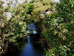
The A633 Barnsley Road crosses at Aldham Bridge, which is followed by another unused railway bridge. Next Stonyford Bridge carries the B6096 road over the river, and Wombwell Ings, an area of low-lying ground and lakes, is located to the south. [3] Wombwell Ings is used as a washland, which is flooded in a controlled way when the river is unable to discharge into the Dearne because of high water levels, which are themselves often the result of high levels in the River Don. They were engineered to act as washlands in 1973, as part of the River Dearne Improvement Scheme. [12] A little further on, the river joins the River Dearne. The total length of this section, including the Blacker Dike, is 7.2 miles (11.6 km) and it has catchment area of 9.73 square miles (25.2 km2). [13] [3]

Water quality

The water quality of the river and its tributaries is variable. The Environment Agency measure water quality of the river systems in England. Each is given an overall ecological status, which may be one of five levels: high, good, moderate, poor and bad. There are several components that are used to determine this, including biological status, which looks at the quantity and varieties of invertebrates, angiosperms and fish. Chemical status, which compares the concentrations of various chemicals against known safe concentrations, is rated good or fail. [14]

The water quality of the Dove was as follows in 2019.

SectionEcological StatusChemical StatusOverall StatusLengthCatchment
Rockley Dike from Source to River Dove [15] Moderate Fail 6.3 miles (10.1 km)6.51 square miles (16.9 km2)heavily modified
Dodworth Dyke from Source to River Dove [16] Good Fail 8.6 miles (13.8 km)6.43 square miles (16.7 km2)heavily modified
Dove from Source to River Dearne [17] Moderate Fail 7.2 miles (11.6 km)9.73 square miles (25.2 km2)heavily modified

The water quality has improved since 2009, when the main river had a poor ecological status, and the overall status was also poor. Like many rivers in the UK, the chemical status changed from good to fail in 2019, due to the presence of polybrominated diphenyl ethers (PBDE), perfluorooctane sulphonate (PFOS) and mercury compounds, none of which had previously been included in the assessment.

Points of interest

Map all coordinates using: OpenStreetMap  
Download coordinates as: KML

Bibliography

Related Research Articles

Sheffield and South Yorkshire Navigation

The Sheffield and South Yorkshire Navigation (S&SY) is a system of navigable inland waterways in South Yorkshire and Lincolnshire, England.

River Douglas, Lancashire river in north-west England

The River Douglas, also known as the River Asland or Astland, flows through parts of Lancashire and Greater Manchester in North West England. It is a tributary of the River Ribble and has several tributaries, the major ones being the River Tawd and the River Yarrow.

River Don, Yorkshire River in South Yorkshire and the East Riding of Yorkshire, England

The River Don is a river in South Yorkshire and the East Riding of Yorkshire, England. It rises in the Pennines, west of Dunford Bridge, and flows for 70 miles (110 km) eastwards, through the Don Valley, via Penistone, Sheffield, Rotherham, Mexborough, Conisbrough, Doncaster and Stainforth. It originally joined the Trent, but was re-engineered by Cornelius Vermuyden as the Dutch River in the 1620s, and now joins the River Ouse at Goole. Don Valley is a UK parliamentary constituency near the Doncaster stretch of the river.

Barnsley Town in South Yorkshire, England

Barnsley is a large market town and the principal settlement of the Metropolitan Borough of Barnsley in South Yorkshire, England. At the 2011 Census, Barnsley had a population of 91,297 out of close to 250,000 in the wider borough in the Dearne Valley. Historically in the West Riding of Yorkshire. It is located between the cities of Sheffield, Manchester, Wakefield, and Leeds. As well as the larger towns of Rotherham, Huddersfield and Halifax being nearby.

River Rother, East Sussex River in East Sussex and Kent, England

The River Rother flows for 35 miles (56 km) through the English counties of East Sussex and Kent. Its source is near Rotherfield in East Sussex, and its mouth is on Rye Bay, part of the English Channel. Prior to 1287, its mouth was further to the east at New Romney, but it changed its course after a great storm blocked its exit to the sea. It was known as the Limen until the sixteenth century. For the final 14 miles (23 km), the river bed is below the high tide level, and Scots Float sluice is used to control levels. It prevents salt water entering the river system at high tides, and retains water in the river during the summer months to ensure the health of the surrounding marsh habitat. Below the sluice, the river is tidal for 3.7 miles (6.0 km).

River Tone River in Somerset, England

The River Tone is a river in the English county of Somerset. The river is about 33 kilometres (21 mi) long. Its source is at Beverton Pond near Huish Champflower in the Brendon Hills, and is dammed at Clatworthy Reservoir. The reservoir outfall continues through Taunton and Curry and Hay Moors, which are designated as a Site of Special Scientific Interest. Finally, it flows into the River Parrett at Burrowbridge.

Barnsley Canal Canal that ran from Barnby Basin, through Barnsley, South Yorkshire, England

The Barnsley Canal is a canal that ran from Barnby Basin, through Barnsley, South Yorkshire, England to a junction with the Aire and Calder Navigation near Wakefield, West Yorkshire. It was built in the 1790s, to provide a transport link from coal reserves at Barnsley to a wider market. Both the Aire and Calder Navigation and the River Don Navigation took a keen interest in the project, the former buying many of the initial shares, and the latter constructing the Dearne and Dove Canal to link the canal to their waterway. Water supply issues meant that the Aire and Calder proposed pumping all of the water for the canal from the River Calder, using steam pumps, but a reservoir was built at Cold Hiendley instead, increasing the construction costs, but reducing the running costs. The canal as built was 14.5 miles (23.3 km) long and included 15 locks.

River Dearne River in South Yorkshire, England

The River Dearne South Yorkshire, England flows roughly east for more than 30 kilometres (19 mi), from its source just inside West Yorkshire. It flows through Denby Dale, Clayton West, Darton, Barnsley, Darfield, Wath upon Dearne, Bolton on Dearne, Adwick upon Dearne and Mexborough to its confluence with the River Don at Denaby Main. Its main tributary is the River Dove, which joins it at Darfield. The river was one of those affected by the 2007 United Kingdom floods.

River Rother, West Sussex River in Hampshire and West Sussex, England

The River Rother flows from Empshott in Hampshire, England, to Stopham in West Sussex, where it joins the River Arun. At 52 kilometres (32 mi) long, most of the river lies within West Sussex except for the first 10 kilometres (6.2 mi) which lie in Hampshire. The upper river, from its source to Midhurst, has been used to power watermills, with the earliest recorded use being in 1086, when the Domesday survey was conducted. Although none are still operational, many of the buildings which housed the mills still exist, and in some cases, still retain their milling machinery. This upper section is also noted for a number of early bridges, which have survived since their construction in the fifteenth, sixteenth and seventeenth centuries.

River Rother, South Yorkshire River in South Yorkshire, England

The River Rother, a waterway in the northern midlands of England, gives its name to the town of Rotherham and to the Rother Valley parliamentary constituency. It rises near Clay Cross in Derbyshire and flows in a generally northwards direction through the centre of Chesterfield, where it feeds the Chesterfield Canal, and on through the Rother Valley Country Park and several districts of Sheffield before joining the River Don at Rotherham in Yorkshire. Historically, it powered a number of mills, mainly corn or flour mills, but most had ceased to operate by the early 20th century, and few of the mill buildings survive.

Metropolitan Borough of Barnsley Metropolitan borough in England

The Metropolitan Borough of Barnsley is a metropolitan borough in South Yorkshire, England; the main settlement is Barnsley and other notable towns include Penistone, Wombwell and Hoyland.

Worsbrough Area in South Yorkshire, England

Worsbrough is an area about two miles south of Barnsley in the metropolitan borough of Barnsley, South Yorkshire, England. Before 1974, Worsbrough had its own urban district council in the West Riding of the historic county of Yorkshire and it is still counted as a separate place from Barnsley by the 2011 Census, but it is often treated as part of Barnsley as the two settlements run into one another.

Worsbrough Mill

Worsbrough Mill, also known as Worsbrough Corn Mill and Worsbrough Mill Farm is a complex of buildings including a seventeenth-century water-powered mill and a nineteenth-century steam-powered mill in Worsbrough, Barnsley, England. The mill is open to the public and takes its water from the River Dove, but is hydraulically separate from Worsbrough Reservoir.

Dearne and Dove Canal Canal in South Yorkshire, England

The Dearne and Dove Canal ran for almost ten miles through South Yorkshire, England from Swinton to Barnsley through nineteen locks, rising 127 feet (39 m). The canal also had two short branches, the Worsbrough branch and the Elsecar branch, both about two miles long with reservoirs at the head of each. The Elsecar branch also has another six locks. The only tunnel was bypassed by a cutting in 1840.

River Devon, Nottinghamshire River in Nottinghamshire, United Kingdom

The River Devon is a tributary of the River Trent, which rises in Leicestershire and joins the Trent at Newark in Nottinghamshire, England. In its upper reaches, it supplies Knipton Reservoir, which was built to supply water to the Grantham Canal, and Belvoir Lakes, designed by Capability Brown. It passes under the Grantham Canal, and then through Bottesford, where it is spanned by five railway bridges, only one of which is still used for its original purpose. On the outskirts of Newark, it passes by two Civil War structures, and just before it joins the Trent it becomes navigable, with a marina located on the west bank. Its name is pronounced "Deevon", not as spelt.

River Frome, Stroud

The River Frome, once also known as the Stroudwater, is a small river in Gloucestershire, England. It is to be distinguished from another River Frome in Gloucestershire, the Bristol Frome, and the nearby River Frome, Herefordshire. The river is approximately 25 miles (40 km) long.

Yorkshire Ring

The Yorkshire Ring is a canal ring in South and West Yorkshire, England. It was completed in 1905 with the construction of the New Junction Canal. It lasted for under thirty years before the closure of part of the Dearne and Dove Canal and subsequently the complete Barnsley Canal. Both these canals are currently under restoration.

The South Yorkshire Railway was a railway company with lines in the West Riding of Yorkshire, England.

Eller Beck River in North Yorkshire, England

The Eller Beck is a small river in North Yorkshire, England, that flows through the town of Skipton and is a tributary of the River Aire. Its channel was heavily modified to supply water to mills in the 18th and 19th centuries, and although all the mills have closed, the water now supplies power to the National Grid, generated by a turbine at High Corn Mill. The beck flows through several underground culverts in Skipton that contribute to the flood risk. To alleviate flooding in Skipton town centre, a scheme involving two flood water storage reservoirs has been designed, but the start of the work to implement it was delayed in October 2014 by a shortfall in funding.

References

  1. Hadfield 1973 , pp. 283–285
  2. "Rockley Dike from source to River Dove". Environment Agency. Retrieved 10 May 2017.
  3. 1 2 3 4 5 6 7 Ordnance Survey, 1:25,000 map
  4. "Dodworth Dike from source to River Dove". Environment Agency. Retrieved 10 May 2017.
  5. Hadfield 1973, pp. 287–288.
  6. Hadfield 1973, p. 419.
  7. 1 2 "Worsbrough Mill". Barnsley Council. Retrieved 10 May 2017.
  8. Historic England. "Worsbrough Corn Mill (1151044)". National Heritage List for England . Retrieved 10 May 2017.
  9. Historic England. "Bridge near Worsbrough Mill Museum (1151045)". National Heritage List for England . Retrieved 10 May 2017.
  10. "New bridge over River Dove". Barnsley MBC. 27 June 2016. Retrieved 9 May 2017.
  11. Butt 1995 , p. 253
  12. Firth 1997, pp. 23–24.
  13. "Dove from source to River Dearne". Environment Agency. Retrieved 10 May 2017.
  14. "Catchment Data Explorer Glossary (see Biological quality element; Chemical status; and Ecological status)". Environment Agency. 17 February 2016.
  15. "Rockley Dike from Source to River Dove". Catchment Data Explorer. Environment Agency. Retrieved 28 October 2021.
  16. "Dodworth Dyke from Source to River Dove". Catchment Data Explorer. Environment Agency. Retrieved 28 October 2021.
  17. "Dove from Source to River Dearne". Catchment Data Explorer. Environment Agency. Retrieved 28 October 2021.

Sources